Lady Well, Airth, Stirlingshire

Holy Well (destroyed):  OS Grid Reference – NS 89801 86524

Also Known as:

  1. Canmore ID 46862
  2. Lady’s Well
  3. Spaw Well

Archaeology & History

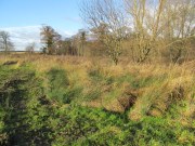
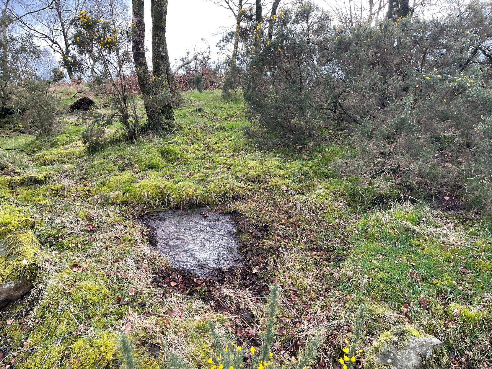
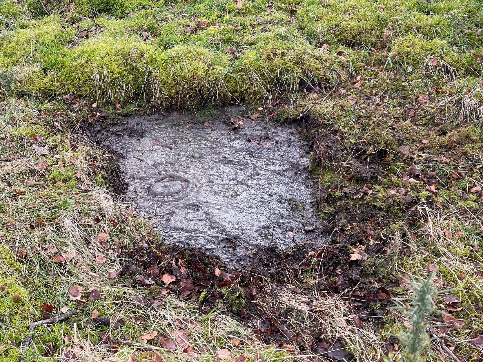
Site of the Lady Well, Airth

Once to be seen flowing on the south-side of the Pow Burn below Airth Castle, all traces of this once sacred site has fallen prey to the usual advance of the so-called ‘civilized’.  In literary terms, the site was first described in church records from 1657—as Ladieswell—and the accounts we have of the place from then are most revealing in describing the traditional use of the place by local people.  It was a sacred site, obviously, chastised by the madness of the christian regime of the period, in their attempt to destroy indigenous customs and societal norms.  William Hone (1837) gave an extended account of what some people were up to here in his Everyday Book:

“In 1657, a mob of parishioners were summoned to the session, for believing in the powers of the well of Airth, a village about six miles north of Falkirk, on the banks of the Forth, and the whole were sentenced to be publicly rebuked for the sin. –

“”Feb. 3, 1757, Session convenit. Compeared Bessie Thomson, who declairit scho went to the well at Airth, and that schoe left money thairat, and after the can was fillat with water, they keepit it from touching the ground till they cam horm.”

“”Ffebruary 24. — Compeired Robert Fuird who declared he went to the well of Airth, and spoke nothing als he went, and that Margrat Walker went with him, and schoe said ye beleif about the well, and left money and ane napkin at the well, and all was done at her injunction.”

“”Compeared Bessie Thomson declarit schoe fetch it horn water from the said well and luit it not touch the ground in homcoming, spoke not as sha went, said the beleif at it, left money and ane nap-kin thair; and all was done at Margrat Walker’s command.”

“”Compeired Margrat Walker who denyit yat scho was at yat well befoir and yat scho gave any directions ”

“”March 10. Compeared Margrat Forsyth being demand it if scho went to the well of Airth, to fetch water thairfrom, spok not by ye waye, luit it not touch ye ground in homcoming? if scho said ye belief? left money and ane napkin at it? Answered affirmatively in every poynt, and yat Nans Brugh directit yem, and yat they had bread at ye well, with them, and yat Nans Burg said shoe wald not be affrayit to goe to yat well at midnight hir alon.”

“”Compeired Nans Burg, denyit yat ever scho had bein at yat well befoir.”

“”Compeired Robert Squir confest he went to yat well at Airth, fetchit hom water untouching ye ground, left money and said ye beleif at it.”

“”March 17. Compeired Robert Cochran, declairit, he went to the well at Airth and ane other well, bot did neither say ye beleif, nor leave money.”

“”Compeired Grissal Hutchin, declairit scho commandit the lasses yat went to yat well, say ye beleif, but dischargit hir dochter.”

“”March 21. Compeired Robert Ffuird who declairit yat Margrat Walker went to ye well of Airth to fetch water to Robert Cowie, and when schoe com thair, scho laid down money in Gods name, and ane napkin in Robert Cowie’s name.”

“”Compeired Jonet Robison who declairit yat when scho was seik, Jean Mathieson com to hir and told hir, that the water of the well of Airth was guid for seik people, and yat the said Jean hir guid sister desyrit hir fetch sum of it to hir guid man as he was seik, bot sho durst never tell him.”

“”These people were all 44 publicly admonishit for superstitious carriage.””

The practices continued.  In 1723, a Mr Johnstoun of Kirkland, writing about the parish of Airth, also told of the reputation of the well, saying,

“Upon the south side of the Pow of Airth, upon its very edge, is a spaw well famous in old times for severall cures, and at this day severalls gets good by it, either by drinking or bathing. Its commonly called by the name of Ladies well. Its about two pair of butts below Abbytown bridge.”

The fact that he told us it was “good for bathing” suggests a pool was adjacent, or at least the tiny tributary between it and the Pow Burn gave room for bathing and had a curative reputation. (there are many pools in the Scottish mountains with this repute – some are still used to this day!)

It was then described by Robert Ure in the first Statistical Account of 1792, where he told how the people were still using the waters, despite the crazy early attempts to stop them.  “There is a Well, near Abbeytown Bridge,” he told,

“called Lady-Well, which is thought to be medicinal.  Numbers have used it, and still use it as such.  It is supposed to have obtained that name, from the holy water, in the time of Popery, being taken from it, to supply the abbacy, or Catholic Church, then at Airth.”

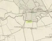
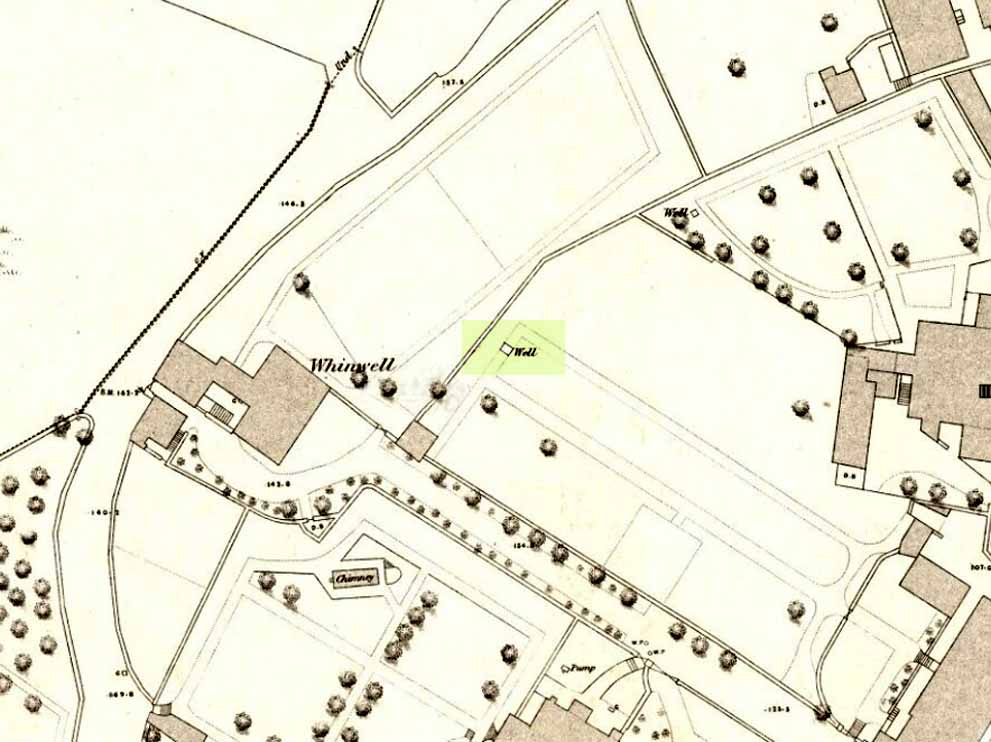
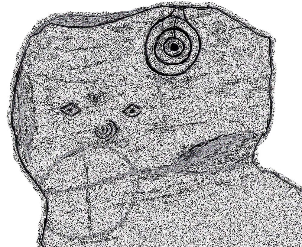
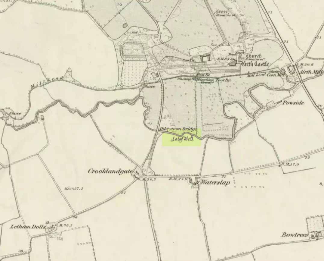
Lady Well on 1865 map

But we know that its origins as a celebrated well pre-date any christian overlay.  People were reported visiting the site from as far away as Edinburgh, such was its repute!

Much later when the Ordnance Survey lads came here, showing it on their first map of Airth, they made their own notes of the place, saying briefly,

“A small well close to the Pow Burn – it is supposed to have derived its name from the Custom of dedicating wells to the Virgin Mary – so Common prior to the Reformation. It is not a mineral well.”

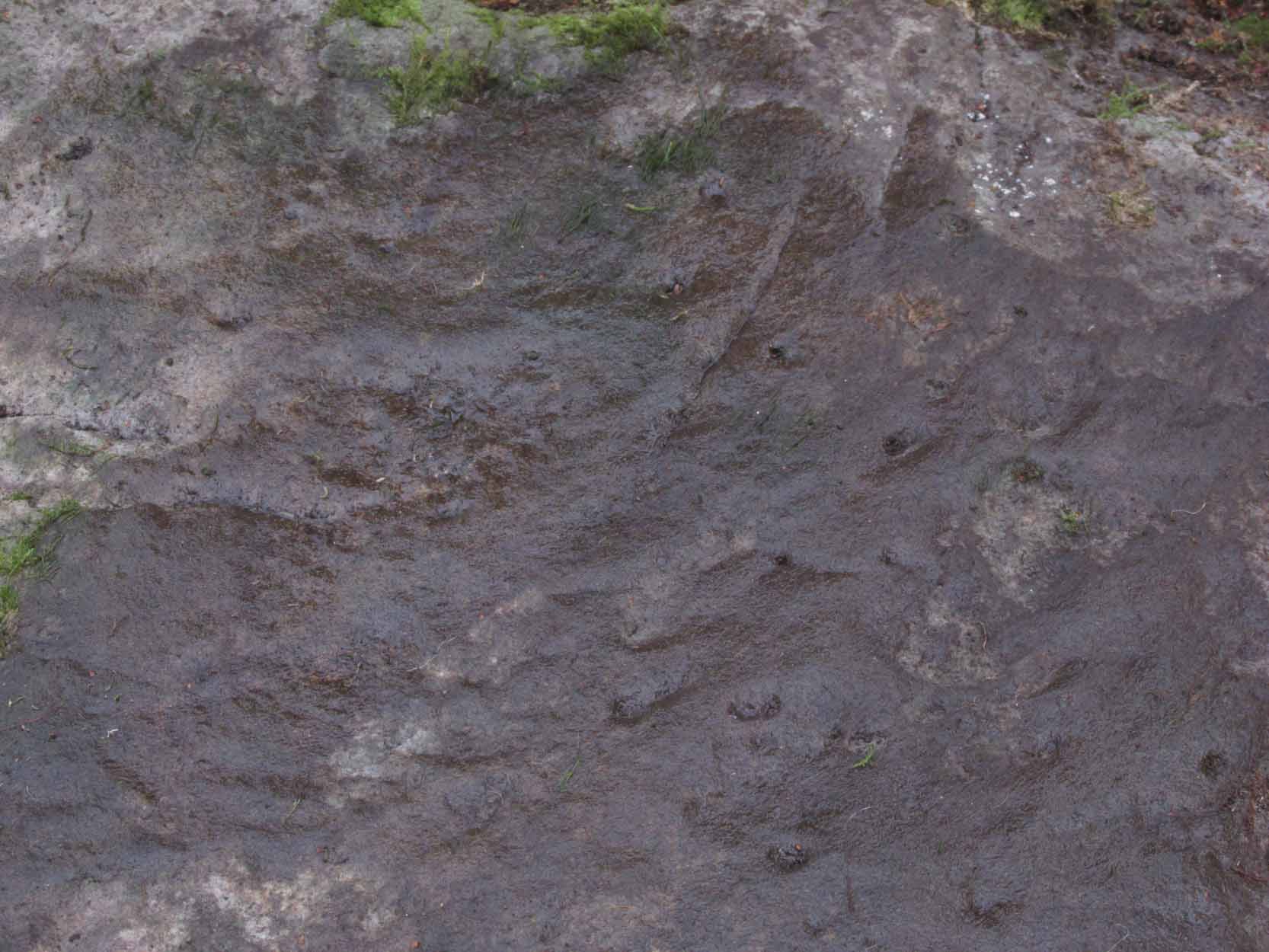
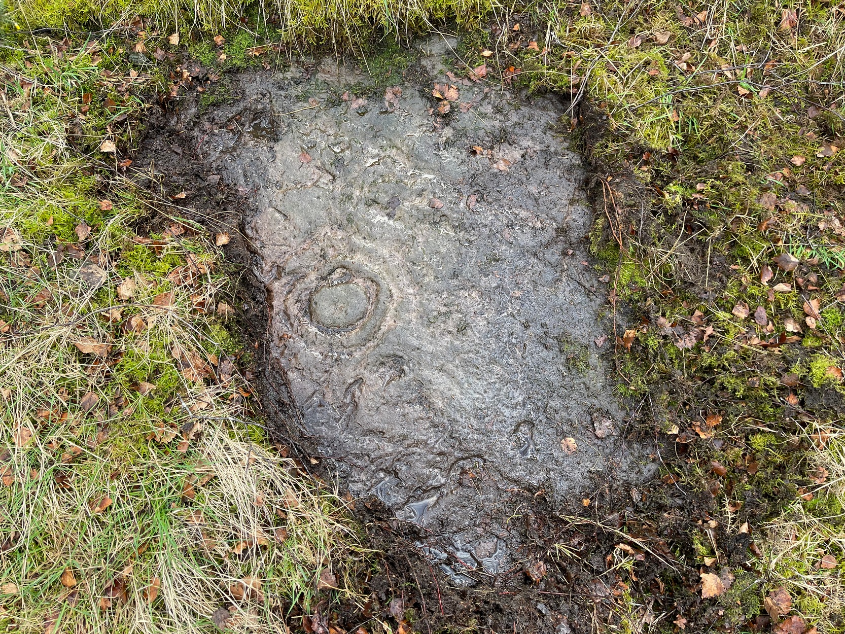
Ugly plastic pipe is all that remains

But its demise was coming.  In the wake of the christian Industrialists and their myth, subsuming the necessary integral sacrality of the Earth, the waters of the well were eventually covered.  When the Royal Commission (1963) lads gave the site their attention in October 1954, they reported that “no structural remains” of any form could be seen here, and in recent years all trace of the well has vanished completely.  When we visited the site a few months ago, perhaps the very last remnant of it was a small plastic pipe sticking out of the muddy bankside, dripping dirty water into the equally dirty Pow Burn.

It would be good if local people could at least put a plaque hereby to remind people of the history and heritage that was once so integral to the way they lived their lives.

References:

  1. Bennett, Paul, Ancient and Holy Wells of Stirling, TNA 2018.
  2. Fraser, Alexander, Northern Folk-lore on Wells and Water, Advertiser Office: Invermess 1878.
  3. Frost, Thomas, “Saints and Holy Wells,” in Bygone Church Life in Scotland (W. Andrews: Hull 1899).
  4. Hone, William, The Every-day Book – volume 2, Thomas Tegg: London 1837.
  5. MacFarlane, Walter, Geographical Collections Relating to Scotland – volume 1, Edinburgh Universoty Press 1906.
  6. MacKinlay, James M., Folklore of Scottish Lochs and Springs, William Hodge: Glasgow 1893.
  7. Morris, Ruth & Frank, Scottish Healing Wells, Alethea: Sandy 1982.
  8. Murray, G.L., Records of Falkirk Parish – volume 1, Duncan & Murray, Falkirk 1887.
  9. Reid, John, The Place-Names of Falkirk and East Stirlingshire, Falkirk Local History Society 2009.
  10. Royal Commission on the Ancient & Historical Monuments Scotland, Stirling – volume 2, HMSO: Edinburgh 1963.

© Paul BennettThe Northern Antiquarian


Wife with the Bratty Plaid, Balfron, Stirlingshire

Standing Stone:  OS Grid Reference – NS 60027 91383

Getting Here

The Wife with the Bratty Plaid

The Wife with the Bratty Plaid

Take the same route as if you’re visiting the small Carlin Stone (a few hundred yards further along): along the B822 road between Kippen and Fintry, stop at Balafark farm and cross the road above the farm to take the track into the forest.  1km along, note the small green track, off the main central track, slightly up on the rise on your right, which bends round and then goes (eventually) to the other side of the forest.  Once you reach the gate at its edge, walk left 285 yards (261m) along the fence.

Archaeology & History

The Wife and the Carlin on the 1865 OS-map

The Wife and the Carlin on the 1865 OS-map

Described in the Ordnance Survey’s (1870) Book of Reference (volume 47) as “a flat rock on the boundary between Perth and Stirling,” the rock is certainly not flat—and any geographical relationship it had with Perth has long since gone.  Instead, the stone in question here is an upright one—although it’s not much more than two feet tall.  However, on the other side of the present-day fence there is a small flat stone in the ground; but it is the moss-covered upright that is our ‘Wife with the Bratty Plaid.’  A smaller curious-looking quartz-lined stone also lies next to this old Wife…

The Wife, looking east

The Wife, looking east

The Wife, looking west

The Wife, looking west

Marked on the ancient boundary line, this small but sturdy standing stone probably has a prehistoric pedigree, although we cannot be certain without an excavation.  It is shown on the earliest OS-maps from the 1860s, but we have no notifications from any literary sources telling the tale behind the stone’s fascinating name: meaning simply, the ‘wife wearing the tartan shawl.’  When Marion Woolley and I came here the other day, we tried to see if a simulacrum of such a figure was hiding in the moss-covered upright—but unlike the notable simulacrum at MacBeth’s Stone, we struggled somewhat here.  It was possible, from certain angles (if we didn’t stand on our heads and poke each other in the eyes!) to see this ‘wife in a shawl’, but twas a struggle…

There’s every likelihood that whatever the old tale once was about this petrified ancestral stone, it would have had some mythic relationship with the Old Wife known as the Carlin, or cailleach, a few hundred yards to the west, at the Carlin Stone.  As yet however, their histories remain hidden in the sleep of the Earth…

Links: 

  1. Nataraja’s Foot – The Wife with the Bratty Plaid

Acknowledgements:  Huge thanks to Marion Grace Woolley, for a truly soggy day out and for the photos in this site profile.

© Paul BennettThe Northern Antiquarian


Todholes, Fintry Hills, Stirlingshire

Cairn:  OS Grid Reference – NS 67761 87011

Also Known as:

  1. Canmore ID 45284

Getting Here

Todholes Cairn one wintry evening

Todholes Cairn one wintry eve

Along the B818 road that runs between Fintry and Denny, get to the western end of the Loch Carron reservoir and park up at the entrance to the forest.  Across the road, walk up the track towards the (planned) wind farm.  Nearly a mile along watch out for the walling of derelict buildings on the slope above the track—but instead of walking up to them (west), walk up the slope on the other side of the track (east), over the annoying fence, then another one barely 50 yards away.  The large fairy mound on the moorland plain barely 100 yards ahead is the site in question.

Archaeology & History

Todholes Cairn looking north

Todholes Cairn looking north

On the day that Paul Hornby, Nina Harris and I visited this site, Nature had been watering Her ground excessively and the moorland was becoming an immense bog.  The daylight was fading fast too, so we didn’t get much time to sit and play and take in the colourful panorama that unfolds its vision as She normally would—and it would be a magnificent view on a clear bright day!  Instead, Her grey carpets and skies darkened quickly, leaving only a bare meander around this old prehistoric tomb before us.  It’s quite a big thing too…

Records of it are scant, both in archaeology accounts and popular culture.  In 1952 the Royal Commission (1963) lads visited the site and subsequently wrote that:

“This cairn…consists of a grass-covered mound of stones which stands to a height of 8ft and measures about 55ft in diameter. Two large boulders which lie at the foot of the mound to the south may represent the remains of a peristalith.  Three small holes caused by quarrying or by excavation appear on the surface of the cairn.”

Another cairn can be found a short distance northwest and what seems to be the remains of a prehistoric hut circle was visible on the moorland plain a few hundred yards south.  The word ‘todholes’ derives from ‘the abode of foxes’—and I saw two dead foxes recently shot by local land-owners hereby, showing that the place-name is valid.

References:

  1. Royal Commission on the Ancient & Historical Monuments Scotland, Stirlingshire – volume 1, HMSO: Edinburgh 1963.
  2. Royal Commission on the Ancient & Historical Monuments of Scotland, Archaeological Sites and Monuments of Stirling District, Central Region, Society of Antiquaries of Scotland 1979.

© Paul BennettThe Northern Antiquarian


St. Ninian’s Well, Stirling, Stirlingshire

Holy Well:  OS Grid Reference – NS 79690 93012

Also Known as:

  1. Canmore ID 46210
  2. St. Ringan’s Well

Getting Here

St Ninian's Well, Stirling

St Ninian’s Well, Stirling

A short distance south out of Stirling town centre, along Port Street where it meets with Ninian’s Road, walk across at the traffic lights then turn immediately left down Wellgreen Road.  Barely 100 yards down (before you reach the roundabout), note the path on your right.  Walk along here and as it bends round into the car-park, look to your left and see the small ivy-covered building hiding away in below you, with an information plaque at its side.

Archaeology & History

“St Ninian’s” is a district unto itself on the south side of the ancient city of Stirling—and it has this holy well (and the demolished chapel that once stood by its side) to thank for this. James Johnston’s (1904) place-name study of the region showed that it had acquired its association with St Ninian as early as 1242 CE when it was described, “Ecclesia Sancti Niniani de Kirketoune.”  It was mentioned again in 1301 CE as the site of “Saint Rineyan”, or St Ringan, which was the other name given to this saint who spent much of his time at Whithorn, Galloway, where he “preached the gospel among the southern Picts.” (Attwater 1965)

The waters in the building

The waters in the building

The old well building

The old well building

At some later date, Ninian is thought to have ventured north and sanctified this already renowned water source which, in his day, would have been open and surrounded by ancient trees and an abundance of wild flowers and healing plants.  But today, typically, it is hiding almost secretly away, behind locked doors and not in view for the general public.  This needs to be changed!  Standing outside of the unkempt and overgrown building, you can faintly hear these ancient waters still flowing within their darkened enclave.

It has been described in a number of local history books down the years, but a lot of the old stories and traditions have sadly moved into forgotten memories… The first major description of the site was by J.R. Walker (1883) who wrote freshly about it soon after his visit—despite being “disappointed” with the architectural features of the building built over the well; which is hardly the right attitude as far as I’m concerned!  The waters, their natural environment, feeling and genius loci are the primary features to sacred wells—nottheir dissolution, nor the artifice of humans to contain and reduce the natural world at such a place!  But, this aside:  for the architects amongst you, here’s what Walker had to say about the well-house:

“Mr T.S.  Muir, in his Characteristics of Old Church Architecture, mentions it as “a large vaulted building with a chamber above it, which is supposed to have been a chapel.” From this notice I was led to think something of interest would be found in the chamber; but as will be seen by the drawing…it is utterly destitute of any feature worthy of particular notice.  On looking at the surroundings, however, which are all modern, and mostly new houses and streets in course of erection, I came to the conclusion that at no distant date the well was doomed, and that consequently I had better make a correct drawing of it.

“The lower chamber measures 16 feet by 11 feet 1 inch, and is covered with a vault running from end to end, measuring from floor to springing 2 feet 9 inches, and from floor to crown of arch 6 feet.  At the end where the spring rises there is a square recess 1 foot 9 inches high and 1 foot 7 inches wide and 17 inches deep; and at the other end two recesses, the largest measuring 2 feet 7 inches in height, 1 foot 4 inches wide and 1 foot 4 inches deep, the other 8 inches high, 8 inches wide, and 8 inches deep.  To what purpose these have been put I have formed no idea; they are on an average 12 inches from the floor to the sill.  The side walls are 2 feet 9 inches thick, and the end gable 3 feet; the other gable, between the well chamber and the adjacent building, being about 2 feet 3 inches.  The room above is the same size as the vaulted chamber below, and is divided by timber partitions to form a dwelling-house.  There is an ordinary fireplace and press in the gable; the press, however, does not go down to the floor, but is simply a recess or “aumbry,” such as we see in old Scotch houses.

“The roof seems to have been renewed at no distant date, although some of the timbers are, without doubt, home-grown.  The ground rises rapidly to the back, so that the entrance door to the house is level with the top of the vault; this door is simply splayed in the Scotch manner, with a square lintel over, and a relieving arch inside.  The door to the well chamber is also splayed, and in like manner the windows; the largest window has been altered, and a new projecting sill put in.

“At present the well is used for washing purposes, and must have been so for a considerable length of time, if we may judge from the table of rates affixed to the building; and a channel has been formed down one side and along the bottom end to carry away the water, the floor being paved with stones.  The vault inside is roughly dressed, very little labour seemingly having been bestowed upon it.

“In the New Statistical Account it is suggested that the chamber was used as a bath, and it also states that, “it is celebrated for its copiousness and its purity. It is a hardish water, but of low specific gravity, and much used for washing. It has been calculated that were all the waters proceeding from this spring forced into the pipes that supply the town, it would afford every individual not less than 14.03 gallons per twenty-four hours.  Its temperature is very cold and it exhibits muriate of lime and sulphate of lime. It is also much used for brewing.”

“Externally the building is roughly cast, or in Scottish phraseology, harled.”

A few years later when J.S. Fleming (1898) wrote an account of the place in his survey of local holy wells, he described a number of other historical elements not included in Walker’s (1883) account, telling:

“RINGAN” is stated to be the Scoto-Irish form of Saint Ninian’s name. He is alleged to have come from Ireland in the fifth century. St. Ringan’s Chapel was one of three attached to St. Ninians, the others being at Skeoch—dedicated to the Virgin Mary—and at Cambusbarron.  The remains of St. Ringan’s Chapel, a simple, barrel-vaulted chamber, 11 feet by 14 feet, built over the spring, are situated a few yards off Pitt Terrace, the upper walls having been built, in 1731, by order of the Stirling Town Council, and formed into a house for the convenience of the town’s washerwomen.  A niche in the north-east wall has evidently been made to hold the image of the Saint; while there has also been a piscina in the same wall. The flow of water is enormous, and enters the building from under the south-west gable, and after passing through the little chamber, flows out at the east wall.  In 1740, the Town Council, considering the large volume of water of some value, entertained the idea of having it conveyed into the town by means of pipes, and consulted an Edinburgh engineer with regard to the feasibility of the project.  Nothing resulted from their efforts, however.  The water of this spring is stated to be so cold in summer that people cannot stand in it for any length of time; while in winter, again, it is so warm that it rapidly thaws whatever is thrown into it.  Smoke rises from it at times, hanging over it like a vapour on a frosty morning.  These characteristics indicate that the waters must issue from a great depth in the ground.

“This Chapel was apparently held in high repute by King James IV., as in the Exchequer Rolls we find the following entries: — “1497, April 24. — Item to the King’s offerand in Saint Ringans Chapel, besid Strivelin, 14/.” ” Samen day to Schir Andro to get say a hental of messes of Saint Ringans, 20⋅/.”

The site was mentioned in the standard surveys of MacKinlay (1893) and Morris (1981), but with very little additional information.

Folklore

Ninian's Well on 1832 map

Ninian’s Well on 1832 map

St. Ninian’s festival date is September 16, but I’ve been unable to find any information about any practices here for that date. However, in 1659, St Ninian’s Well was mentioned as a site used in what the deluded criminal courts of the period called “a case of witchcraft”, against one Bessie Stevenson.  The lady concerned told of performing quite normal herbal practices and similar animistic healing traditions, typical of those found universally in peasant cultures, but which the crazed church-goers saw as something completely different.  Bessie told that for people who were either sick or bewitched, she would wash their clothes in the running waters of St. Ninian’s Well, to wash away any disease and cure the said person.  It is likely that the waters here were commonly used for such rites, much as the christian priesthood still do at many ‘holy waters’ to this very day.  Indeed, of the sacred waters here, St. Ninian himself was said to “have endowed it with peculiar virtues.” (Roger 1853)

References:

  1. Attwater, Donald, The Penguin Dictionary of Saints, Penguin: Harmondsworth 1965.
  2. Fleming, J.S., Old Nooks of Stirling, Delineated and Described, Munro & Jamieson: Stirling 1898.
  3. Johnston, James B., The Place-Names of Stirlingshire, R.S. Shearer 1904.
  4. MacKinlay, James M., Folklore of Scottish Lochs and Springs, William Hodge: Glasgow 1893.
  5. Morris, Ruth & Frank, Scottish Healing Wells, Alethea: Sandy 1982.
  6. Mould, D.D.C.P., Scotland of the Saints, Batsford: London 1952.
  7. Reid, John, The Place-Names of Falkirk and East Stirlingshire, Falkirk Local History Society 2009.
  8. Roger, Charles,  A Week at Bridge of Allan, Adam & Charles Black: Edinburgh 1853.
  9. Ronald, James, Landmarks of Old Stirling, Eneas Mackay: Stirling 1899.
  10. Simpson, W.D., St. Ninian and the Origins of the Christian Church in Scotland, Oliver & Boyd: Edinburgh 1940.
  11. Walker, J. Russel, “‘Holy Wells’ in Scotland,” in Proceedings of the Society of Antiquaries of Scotland, vol.17 (New Series, volume 5), 1883.

© Paul BennettThe Northern Antiquarian


St. Maha’s Well, Buchanan, Stirlingshire

Sacred Well:  OS Grid Reference – NS 4573 9180

Also Known as:

  1. Canmore ID 43475
  2. Saintmaha Well

Getting Here

St Maha's Well on 1865 map

St Maha’s Well on 1865 map

Bittova walk to reach this one.  From The Square in Drymen village, take the long Old Gartmore Road north for 1.4 miles (2.25km) until you reach the West Highland Way track. Turn left and walk along the track for 1.75 miles (2.8km), making sure that you note crossing the large burn as a guide before your next turn, right, uphill and further north. About 400 yards up, you emerge from the forestry plantation and onto the open moorland. Walk about 200 yards (185m) up the track then walk left, right into the boggy moorland. Keep your eyes peeled for a small standing stone on the heath about 130 yards along, and just below this is a stone-lined spring of water.

Archaeology & History

St Maha's Well

St Maha’s Well, near Drymen

This little-known healing spring of water, high upon the moors overlooking the southern isles of Loch Lomond and the mountains beyond, is in a beautiful (if boggy) setting.  We visited here on a somewhat wet day, amidst a wealth of Nature’s downpours in previous days giving us the masks of grey overcast skies and soaking grounds.  Despite this, the setting is gorgeous and, if we’d have visited on a sunny day, the feel and views would be outstanding.  This mighthave been one of the reasons that this particular spring of water was chosen to be sanctified.  Certainly it has an ancient history, if christian tales are anything to go by…

Although listed in the parish of Buchanan, the well resides on the hills above the village of Balmaha more than 2 miles to the west, on the shores of Loch Lomond; and Balmaha is thought to have its origins enwrapped with an early christian characters of some prominence.  The element maha derives, said Watson (1926) from the Scottish Gaelic ‘Mo-Thatha’, from the earlier Irish name Tua, meaning “the silent one.”  The character known as St. Maha gives his name to the village and according to H.G. Smith (1896),

Bal maha may most probably retain the memory of St Mochai or Macai; Latin, Maccaeus, also known as St Mahew, a companion to St Patrick, to whom the church of Kilmahew in Cardross was dedicated.  Mahew lived at Kingarth in Bute, and Buchanan formed part of the district superintended by Kingarth.  He was a poet, physician, and noted in his day for his mathematical learning… (St Mahew’s day was 11 April).”

Close-up of the waters and stone surround

Close-up of the waters and its stone surround

It seems therefore probable that this poet-healer character underlies the old name at this well.  St. Maha’s attributes as a poet and healer would suggest he was trained in archaic techniques before declaring himself as ‘christian.’  In the landscape nearby are other early Irish christian traditions, pasted onto much earlier heathen ingredients.

When Mr Smith (1896) wrote about the well, the remains of an old tree still grew above the waters onto which local people left memaws and offerings for the resident spirit, maintaining the animistic traditions of popular culture that still endure.  He wrote:

“St Maha’s Well is in an upper field of the farm of Crietihall.  It was of old a healing well, and in the memory of man pieces of cloth used to be fastened to a tree which overshadowed it, votive offerings by the pilgrims who sought the saint’s favour.”

…Although in truth, “the saint’s favour” is mere window dressing for the more archaic and natural feel of the site: what John Michell (1975) would have termed the “resident Earth spirit.”

The well is surrounded by a small arc of stone masonry, which the ever-reliable Royal Commission (1963) lads tell us, “measures 2ft by 3ft internally and stands about 1ft above the surface of the water.”  Just above the well itself is a small rise with a standing stone at its edge—probably medieval in origin.  Barely three feet tall, it sits upon an overgrown arc of stones that curves around the hillock reaching down towards the well and was obviously a small building of some sort in previous centuries.  Its precise nature is unknown, but it has been suggested to have either been an earlier well-house or surround, or perhaps the remains of a hermit’s cell—even St. Maha himself—that has fallen away over time.  Without an excavation, we may never know what it was!

Little Leo by the little stone

Little Leo by the little stone

Aisha with Leo, shortly before he threw himself in!

Aisha with Leo, shortly before he threw himself in!

Whatever the origin behind the small standing stone and the overgrown scatter of rocks, one of our adventurers on the day we visited—little Leo—was fascinated by it, almost attaching himself to it and stroking his way round and round the old stone with playful endurance.  And then, when he got to see the sacred spring below, became so taken by it that he simply sat down in the waters without as much as making a gasp, despite the cold!  Aisha (his mum) would pick him up, only for him to walk right back over and sit himself right back into it again!  It was both comical and fascinating to watch and he seemed quite at home in the pool, despite being drenched and cold.  Indeed, he took exception to being lifted out of the water—and simply plonked himself back in it again!

Folklore

The Canmore website tells some intriguing folklore about the place, saying:

“The well is still a focus of local cult, and is visited by people who leave offerings in the water. A man dying recently in a local hospital refused to drink any water except water taken from this well.”

References:

  1. Edlin, Herbert L. (ed.), Queen Elizabeth Forest Park, HMSO: Edinburgh 1973.
  2. Johnston, James B., The Place-Names of Stirlingshire, R.S. Shearer 1904.
  3. Michell, John, The Earth Spirit: Its Ways, Shrines and Sanctuaries, Thames & Hudson: London 1975.
  4. Morris, Ruth & Frank, Scottish Healing Wells, Alethea: Sandy 1982.
  5. Nicholson, A. & Beaton, J.M., “Gaelic Place-Names and their Derivations,” in Edlin’s Queen Elizabeth Forest Park, HMSO: Edinburgh 1973.
  6. Royal Commission on the Ancient & Historical Monuments Scotland, Stirling – volume 1, HMSO: Edinburgh 1963.
  7. Smith, H. Guthrie, Strathendrick and its Inhabitants from Early Times, James Maclehose: Glasgow 1896.
  8. Watson, W.J., The History of the Celtic Place-names of Scotland, Edinburgh 1926.

Acknowledgements:  Many thanks to Aisha Domleo, Lara Domleo, Leo (the stone-hugger) Domleo, Unabel Gordon, Nina Harris, Paul Hornby and Naomi Ross for their help and attendance in finding and falling about this ancient sacred well. A damn good wet day all round!

© Paul BennettThe Northern Antiquarian


Our Lady’s Well, Stirling, Stirlingshire

Holy Well (destroyed):  OS Grid Reference – NS 7932 9454 

Also Known as:

  1. Whiskey Well
  2. Whusky Well

Archaeology & History

Fleming's 1898 drawing of Our Lady Well

Fleming’s 1898 drawing of Our Lady Well

Once found beneath the northern foot of Gowan Hill, below the old hillfort and close to Stirling’s famous castle, the Industrialists, as usual, built over and destroyed this piece of ancient heritage in the 20th century, leaving us only a few words and an old drawing to remember it by.  It was one of several holy wells in and around Stirling, most of which have fallen prey to the same scavengers in the march they call ‘progress.’

Thankfully the local writer J.S. Fleming’s (1898) talked about the well in his fine work, where he told:

“This Well is situated at the foot of the Gowan Hills, and adjacent to the skating pond, as shown in (the) sketch.  Though part of the waters of this Well have been abstracted, and led, by means of a pipe, to a neighbouring factory, it still gives off a considerable flow of water.  The local name, “Whusky Well” is supposed to be given this Well on account of the virtues of its waters for mixing with whisky, without any perceptible deterioration of the latter.  We can find no allusion to this Well in any of the Burgh Records, and Dr. Rogers gives no reason for its dedication to the Virgin Mary.  We do know, however, that “St. James’s Chapel of the Crag” was situated only 200 or 300 yards distant, and is referred to frequently as receiving alms from King James IV, especially on 26th July, 1496, of 14s.  We learn from a charter by Robert III to the Canon of Cambuskenneth Abbey, dated 10th March, 1402, that he grants “to God, and the blessed Virgin Mary, and to the said Canon,” this Chapel, or Hospital of St. James, at the end of the roadway of the Bridge of Stirling; and that King James II, on 24th June, 1456, grants the said Chapel, or Hospital, to the town of Stirling, ” to the praise and honour of God, the blessed Virgin Mary, his mother, and Saint James the Apostle.” May not this well have had connection with St. James’s chapel, an appanage of Cambuskenneth Abbey, dedicated to our Lady the Virgin, and thus give reason for its name, ” Our Lady Well? ” Saint James’s Chapel was held by Sir Robert Cristisoun, as part of his emoluments as master of the Grammar School, whose right was challenged in 1522; and in November, 1562, having become ruinous, the stones of the Chapel were directed by the Magistrates to be “brocht to the utility and profit of the common work,” — strengthening the town’s wall.  A northern boundary, in a charter of the Abbot of Aberbrothock, dated 1299, of lands in the burgh, is described as “the land of Saint Marie of Strivelin.” There is also “a Ladyrig,” but its situation is not indicated and, therefore, its connection with the Well is hypothetical.”

In early references of the site by Ordnance Survey in the 1860s and 1890s, it was only described and shown as the Whiskey Well.

References:

  1. Bennett, Paul, Holy Wells and Healing Springs of Stirling and District, forthcoming
  2. Fleming, J.S., Old Nooks of Stirling, Delineated and Described, Munro & Jamieson: Stirling 1898.
  3. Roger, Charles, A Week at Bridge of Allan, Adam & Charles Black: Edinburgh 1853.

© Paul BennettThe Northern Antiquarian


Bishop’s Well, Dunblane, Stirlingshire

Holy Well (destroyed):  OS Grid Reference – NN 78126 01281

Also Known as:

  1. Canmore ID 24681

Archaeology & History

Bishop’s Well on 1899 map

This now-lost holy well was a place whose history was integrally tied to the adjacent and also destroyed Bishop’s Palace: a large ostentatious building that was already in ruins in 1579, just below Dunblane Cathedral. It was the water supply for the bishops who lived here; although exactly when it received its original dedication, and by whom, seems unknown.

The best description we have of it is in Alex Barty’s (1944) excellent history work on Dunblane, where he wrote:

“Perhaps the best-known well in Dunblane was the Bishop’s Well, in the Bishop’s Yard or Grassyard.  This well is now dry and the explanation is that it was fed by a strong stream from about Kirk Street which was incorporated into the town sewer when it was laid in Kirk Street.  There was a right-of-way, or at least a  privilege, held by some of the inhabitants to pass through the north end of the Manse ground out by a gate which still exists and down a path to the well.”

Mr Barty informed us that the line of the footpath was still visible in his day, but it has long since gone.  When Archie McKerrarcher (1992) wrote about the site, he described minor remains of it still extant, telling that “the Bishop’s Well can be seen marked by circular stonework in the grass”; but this has now also been destroyed.  One would think that the local christian community would at least have tried to preserve this ancient site.

References:

  1. Barty, Alexander B., The History of Dunblane, Eneas Mackay: Stirling 1944.
  2. Dennison, E.P. & Coleman, R., Historic Dunblane: The Archaeological Implications of Development, RCAHMS: Edinburgh 1997.
  3. McKerracher, Archie, The Street and Place-Names of Dunblane and District, Stirling District Libraries 1991.

Acknowledgements:  To Paul Hornby in his help seeking out this site; and to the staff at Dunblane Library.

© Paul BennettThe Northern Antiquarian


Airthrey Mineral Wells, Bridge of Allan, Stirlingshire

Healing Wells:  OS Grid Reference – NS 79504 97686

Also Known as:

  1. Airthrey Spa
  2. Airthrey Springs
  3. Bridge of Allan Spa
  4. Canmore ID 317260

Getting Here

Site shown on 1865 OS map

The old well-house is accessed easily.  From the main road of Henderson Street (or A9), that runs through the town, as you approach the main shopping area, go up Alexander Drive, then immediately turn right up Well Road. 100 yards up, take your first right again along Kenilworth Road and then first right up Mine Road.  100 yards or so along here, as you reach the tennis courts on your right, a small crumbly-tumbly building is to your left, just by the car-park to the hotel, with some old trees hiding its presence.  You can’t get into it and the waters therein sound to have fallen silent.

Archaeology & History

In 1761, the great writer Daniel Defoe in his Tour across Britain, found himself visiting a healing spring under the western reaches of the Ochils:

“Airthrey Well, two miles north of Stirling, flows from a mountain, where is a copper mine, with some mixture of gold; the water is very cold, and being tinctured with the minerals it flows through, is of use against outward distempers.”

Airthrey Wellhouse in ruins

Perhaps the earliest literary description of this site, the Bridge of Allan that we see today was little more than a stretch of old abodes, reaching into woodland above the crystal clear river and burns, chiming with countless fauna and that rich chorus of colours that pre-date the Industrialist’s ‘progress’.  The old hamlet was said by Robert Chambers (1827) to be “a confusion of straw-roofed cottages and rich massy trees; possessed of a bridge and a mill, together with kail-yards, bee-skeps, colleys, callants, and old inns.” But all of this was about to change.

In the old woods on the northwest slopes above the hamlet was indeed an old copper mine as Defoe described, and housed therein were a number of mineral springs–six of them according to the early reports of Forrest (1831) and Thomson. (1827)  They were obviously “known to the country people,” said Thomson, and had been “used by them as an occasional remedy for more than forty years”; although in Forrest’s very detailed account of these wells, he told how

“one of the old miners, an intelligent man and an enthusiastic admirer of the medicinal virtues of these waters, informs me, that they have been known for at least one hundred years.”

This comment was echoed a few years later when Charles Roger (1853) wrote his extensive book on the village.

It was in the 1790s when the mineral waters were channeled out of the mines for the first time, and Mr Forrest told that they were collected lower down the slope,

“in a wooden trough, for the use of the miners, and of the country people, some of whom used it as an aperient, whilst others, deeming the water impregnated with common salt merely, employed it for culinary purposes. …It was…much used as a medicine by the country people of the neighbourhood who attended regularly every Sunday morning to partake of it.”

Airthrey waters channeled along the long trough (Robert Mitchell 1831)

The fact that Sunday mornings was when people came here tell us that the Church had something to do with the timing; strongly implying that the wells possessed earlier indigenous traditions—probably similar to those practiced at the Christ’s Well, the Chapel Well and countless others across the country.  But written records on this are silent.

The main history of the Airthrey Springs is of them becoming famous Spa Wells and, much like Harrogate in Yorkshire, were responsible for the very growth of Bridge of Allan itself.  Oddly enough, this came about a few years after the copper mines were closed in 1807.  This wouldn’t have stopped some of the local people still getting into them and drinking the waters when needed—but the written records simply tell that, for a few years at least, their reputation faded.  Around the same time in the village of Dunblane, just a few miles to the north, another Spa Well had been discovered and it was attracting quite a lot of those rich wealthy types—bringing fame and money to the area.  As a result of this, the medicinal virtues of the Airthrey Springs were revived thanks to the attention of the local lord, a Mr Robert Abercromby, who thought that Bridge of Allan could gain a reputation of his own.  And so in the winter of 1821-22, Abercromby procured the research chemist Thomas Thompson to analyse the medicinal waters at Airthrey and have them compared with the ones at Dunblane.  He was in luck! Not only were they medicinal, they were incredibly medicinal!

Dr Thomson then wrote a series of articles in various academic journals in the early 19th century—each espousing, not just the health-giving property of the Airthrey waters, but lengthy chemical analyses outlining the active constituents.  To his considerable surprise he found that the Airthrey waters were as good as any of the great spa towns in England at Harrogate, Buxton, Bath and Leamington.  Their virtues were so good that Mr Forrest (1831) doubted any of the Spa Wells in England were as beneficial as the waters here!  R.M. Fergusson (1905) echoed this sentiment in his massive work on the adjacent parish of Logie, calling the Airthrey springs “the Queen of Scottish Spas”!—and these accolades prevailed long after Dr Thomson’s analyses.  He wrote:

“At Airthrey there are six springs containing, all of them, the same saline constituents, but differing a good deal in their relative strengths. I analyzed two of these during the winter of 1821-22, and the other four during the autumn of 1827.”

He found that, in varying degrees, the main constituents were salt, muriate of lime, sulphate of lime and muriate of magnesia. At that time, in medical circles, these ingredients were beauties!  As Mr Logie (1905) said:

“This mineral water has been for long distinguished as a specific for derangements of the stomach and liver, and skin and chest diseases, rheumatism, gout, sciatica, and nerve affections…”

Thomson’s initial findings were much to the liking of Mr Abercromby; for hereafter, he realised, all and sundry who could read and travel to the country spas in England and beyond, would visit Bridge of Allan and bring with it great trade.  So Abercromby quickly,

“caused the water of the two Springs analysed by Dr. Thomson, one of which was characterised by its strength, the other by its comparative weakness, to be carefully collected and conveyed apart in earthen pipes, to two stone troughs placed in a convenient situation, from which it was raised by two well-constructed forcing pumps. Over these pumps a commodious house was erected.

In 1822, several thousand copies of Dr. Thomson’s analyses were circulated; and the water acquired immediate celebrity.  Invalids from all parts of the country, but especially from Glasgow and its vicinity, resorted to Airthrey. Every house, in fact, in its neighbourhood, however mean and incommodious, was occupied by strangers; and so great was the popularity of the new springs that even in 1823 they threatened to supersede all the other same springs of Scotland.”

The success of these medicinal waters created the town itself and, unlike many other spa wells, this one continued to be used until the end of the 1950s.  Its demise came when, in one financial year, only two people came to “take the cure,” as it was called.

Side wall of ruined wellhouse

If you visit the well-house nowadays, it’s in rather poor condition and will be of little interest unless you’re a devout architectural fanatic.  It’s thought to be the earliest surviving building associated with this spa town, said by Mr Roger (1853) to have been built in 1821.  Shown on the first OS-map of the area, adjacent buildings were constructed to accommodate the overflow of people who came here.  And in the woodlands above, if you look around halfway up the slopes, an old trough has water running into it just by the side of a path.  This, say some local folk, is the trickling remains of the medicinal waters, still used occasionally by some people…

References:

  1. Durie, Alastair J., “Bridge of Allan: Queen of the Scottish Spas,” in Forth Naturalist & Historian, volume 16, 1993.
  2. Erskine, John, Guide to Bridge of Allan, Observer Press: Stirling: 1901.
  3. Fergusson, R. Menzies, Logie: A Parish History – 2 volumes, Alexander Gardner: Paisley 1905.
  4. Forrest, W.H., Report, Chemical and Medical, of the Airthrey Mineral Springs, John Hewit: Stirling 1831.
  5. Morris, Ruth & Frank, Scottish Healing Wells, Alethea: Sandy 1982.
  6. Roger, Charles, A Week at Bridge of Allan, Adam & Charles Black: Edinburgh 1853.
  7. Stewart, Peter G., Essay on the Dunblane Mineral Springs, Hewit: Dunblane 1839.
  8. Thomson, Thomas, “On the Mineral Waters of Scotland,” in Glasgow Medical Journal, volume 1, 1827.
  9. Turner, E.S., Taking the Cure, Michael Joseph: London 1967.

© Paul BennettThe Northern Antiquarian


Lady Betty’s Well, Leckie, Gargunnock, Stirlingshire

Holy Well:  OS Grid Reference – NS 69441 94687

Getting Here

Lady Bettys Well, nr Leckie

From Gargunnock village, take the road west towards Leckie, and then just before the right-angled bend in the road down towards the A811, bear sharp left, and then immediate right below the farmhouse along what looks like a private road taking you onto the Watson House mansion.  About 500 yards along, with trees either side of you, look down the small steep slope where a small burn (stream) is visible. Get down there and, where the waters bend away changing direction to head north, look carefully for a small spring of water emerging, just a few yards south of the stream itself, beneath a young tree.

Archaeology & History

Lady Bettys Well on 1860 map

This all-but-forgotten water source is, thankfully, still running with clear waters below the wooded slopes.  It is highlighted on the first OS-map of the region in 1860, 50-60 yards east of a small but once-picturesque waterfall (now spoiled by a mass of industrial waste, dumped hereby).  Little seems to be known about its mythic history and, quite possibly, may have had something to do with our old cailleach.  May have…. I say this purely in relation to what was said about the site by the Ordnance Survey lads at the end of the 1850s when they visited the site and enquired as to its name and nature.  They told:

“A Small Spring issuing from under a rock like the mouth of a drain having no appearance of a Well.  It took its name (Betty) from an old woman who lived adjacent some two hundred years ago; there is no tradition or Antiquity connected with it – nothing more nor less than an Old woman’s well, but is well known in the neighbourhood by the name. Situated at the base of Craigmakessoch and about 10 chains north west of Leckie house.”

Water emerging by the roots

Although ‘Betty’ is obviously a shortening of Elizabeth, it’s the Old Woman’s bit that brings up the cailleach element, which may or may not be valid.  The small crag beneath which the spring still rises is known as ‘Craigmakessoch’, which Prof Paul Hornby thought might derive from a forgotten attribution to the little-known St. Makessog or Kessog. (are there any local folk who can clarify things?)

Were it not for the pollution due to the dumping here (in an otherwise beautiful place), it looks like the waters would still be drinkable – but we all decided to give it a miss…

© Paul BennettThe Northern Antiquarian


Machar Stones, Fintry, Stirlingshire

Standing Stones:  OS Grid Reference – NS 65705 83932

Also Known as:

  1. Canmore ID 45311
  2. Waterhead Stones

Getting Here

The Machar Stones

The Machar Stones

Of the 2 ways to reach here: one via the Crow Road, up to Waterhead Farm and then meandering through the forest—we took the other one!  From the car park at the western end of Carron Reservoir, take the track into the forest. Stick to the track closest to the loch until, after crossing the small river bridge, veer right at the next junction 200 yards on.  Another 600 yards (0.5km) along, take the right turn and walk all along this track to the very end.  From here, take your feet down into the opening along the small burn and stick to this gap in the trees for 100 yards or so, where the gap in the trees veers left.  Keep walking for another 200 yards.

Archaeology & History

These stones might take some finding, but they’re worth the effort if you like your megaliths.  When Nina, Paul and I visited them yesterday, the meander turned into what have become known as Barmy Bennett Bimbles as we ventured off-path and into the forest, wading through marshland and getting our eyes poked out in the dense trees!  And then the snow came. Twas gorgeous to be honest…

Machar Stones, looking SE

Machar Stones, looking SE

Machar Stones, looking west

Machar Stones, looking west

Probably neolithic in origin, the Machar Stones are set upon an elevated rise above the confluence of the Bin Burn and the River Carron on what seems to be an enhanced artificial platform, akin to those which some stone circles and ring cairns are mounted upon. Around the edges of the stones themselves, the earth has been dug into at some point in the past, as evidenced by the distinct oval dip in the ground surrounding the stones; although I can find no antiquarian accounts describing such a dig.  There is the possibility that these stones may once have marked the site of a prehistoric tomb.

Once you walk ten yards away from the stones in any direction, you begin to walk downhill.  Sadly the trees presently obscure any view from the stones, completely silencing the panorama that quite intentionally awoke from here in centuries gone by, disabling any immediate visual landscape analysis or geomancy.  The proximity of the two rivers was probably relevant in the construction of the stones; as may be the ridge between the Little and Meikle Bin to the southeast.

First described in Nimmo’s Stirlingshire (1817) as “a druidical remain…in the parish of Fintry, about the middle of the moor towards Campsie and northwest of the Meikle Bin”, another early account of these megaliths was in H.G. Smith’s (1896) work on the parish of Strathendrick, before the imposition of the modern ‘forest’ occurred and the views from the stones were unrestricted.  After describing their geographical position, he told:

“On a comparatively level part of the muirland between the two rivers and under Meikle Bin, there are two old standing stones known locally as the Machar Stones, this name being derived from the Gaelic magh, a plain.  The more northerly stones measures 8 feet in height, and the other is 5 feet 7 inches high.  Little…is known of the origin of these standing stones… They were apparently in some way connected with the religious worship of the prehistoric inhabitants of the land.  The general uniform direction in which they point, which is to the north of east, looking as nearly as possible to the quarter of sunrise at the summer solstice, seems to point to their having been erected by a race of sun worshippers.”

Machar Stones, looking NW

Machar Stones, looking NW

Around the same time, A.F. Hutchison (1893) gave a lecture on these and other Stirlingshire megaliths, giving slight variants on the heights of the monoliths, adding that “the two stones are standing in a line pointing to 220°.”  Sadly, even the great authorities of Aubrey Burl (1993) and Alexander Thom (1990), in their respective tomes on the subject, were unable to define any astronomical alignments here.  Hutchison puzzled about the seeming artificiality of the platform upon which the stones appear to have been set, though wrote how “geological authority pronounces it to be a quite natural formation.”

As to the name of the site, William Grant (1963) ascribes the word ‘Machar’ and its variants to mean “a stretch of low-lying land adjacent to the sand” or “low-lying fertile plain”—which doesn’t seem relevant here, unless it was so named by people living on the higher grounds.  It seems odd… As does the alignment of the stones.  When Nina Harris stood between the stones with a compass to work out the cardinal points, the stone that was leaning was due north of the upright stone.  When she walked several yards away from them, the compass deviated and we were given a more northeast-southwest alignment from stone to stone.  This isn’t too unusual as we find similar magnetic anomalies at other megalithic sites in Britain (see Devereux 1989), due to a variety of geophysical ingredients.

Royal Commission 1954 photo

Royal Commission 1954 photo

Not that your bog standard archaeo-tomes ever mention magnetic anomalies, as basic physics is too complex a subject for your standard archaeo-types!  Instead however, we just get the usual measurements and data-sets, much as the Royal Commission (1963) lads gave us after their visit here in 1954—but at least there was no forest when they came here!  They were fortunate.  “These two stones,” they told us,

“stand on a slight eminence in open moorland, half a mile ENE of Waterhead farmhouse and at an elevation of 850ft… Described by Nimmo’s editor as “a Druidical remain”, they have also been nown as the Machar Stones.  The more northerly stone, a four-sided pillar of irregular section, has fallen almost prostrate and its whole length, 7ft 6in, is revealed.  At the centre it measures 3ft in width by 2ft 6in in breadth.  The other stone stands 4ft 6in further S.  It is a slab…standing to a height of 5ft and measuring about 2ft in thickness.  Its width is 2ft 8in at ground level, 3ft 8in at a point 2ft above this, and 2ft at the top.”

They posit the idea that the reason the taller stone is leaning at such an angle was due to there being a prehistoric cist nearby which had been ‘excavated’ by peoples unknown, who then took it upon themselves to explore the Machar Stones with similar venture.

The 'cup-marked' stone

The ‘cup-marked’ stone

In recent years it has been said that there are cup-markings on the leaning stone, seven of them apparently.  When we visited yesterday they were difficult to make out.  There were a number of ‘cups’ on the stone, but these were debatable and seemed more the result of conglomerate disintegration than man-made.  A couple of them were perhaps ‘possibles’.  However, the light was poor and I’d prefer another visit before making my mind up!

The Machar Stones are quite evocative megaliths, despite their lack of grandeur.  Maybe it was the snow.  Maybe it was the trees.  Maybe it was me.  Or probably a mix of all three and more; but this had a real feel to the place.  Well hidden, miles from human touch or visits, awaiting just the occasional visitor—and in this weather (of floods, downpours, cold and snow) saturated humans would be the only sorts of crazy people whose spirits would risk getting completely lost to find them.  And my god were they worth the effort!  Paul, Nina and I thought so anyway!

References:

  1. Burl, Aubrey, From Carnac to Callanish, Yale University Press 1993.
  2. Devereux, Paul, Places of Power, Blandford: London 1990.
  3. Feachem, Richard, Guide to Prehistoric Scotland, Batsford: London 1977.
  4. Grant, William (ed.), Scottish National Dictionary – volume 6, SNDA: Edinburgh 1963.
  5. Hutchison, A.F., “The Standing Stones of Stirling District,” in The Stirling Antiquary, volume 1, 1893.
  6. Nimmo. William, History of Stirlingshire, Andrew Bean: Stirling 1817.
  7. Royal Commission on the Ancient & Historical Monuments Scotland, Stirlingshire – volume 1, HMSO: Edinburgh 1963.
  8. Royal Commission on the Ancient & Historical Monuments of Scotland, Archaeological Sites and Monuments of Stirling District, Central Region, Society of Antiquaries of Scotland 1979.
  9. Smith, H. Guthrie, Strathendrick and its Inhabitants from Early Times, James Maclehose: Glasgow 1896.
  10. Thom, A., Thom, A.S. & Burl, Aubrey, Stone Rows and Standing Stones – 2 volumes, BAR: Oxford 1990.

Acknowledgements:  Huge thanks to Nina Harris and Paul Hornby for their endurance and endeavor in locating these great old stones, in attendance with the great rain, snow and deep muddy bogs!

© Paul BennettThe Northern Antiquarian