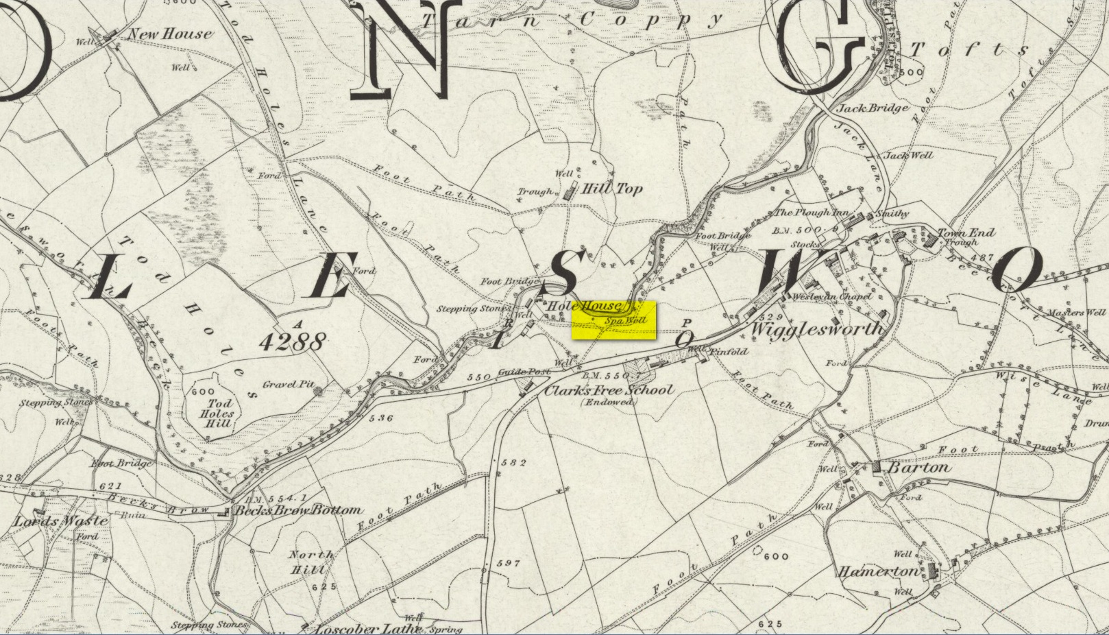
Healing Well: OS Grid Reference – SD 8055 5677
Also Known as:
- Spa Well
- Wigglesworth Spa
Archaeology & History
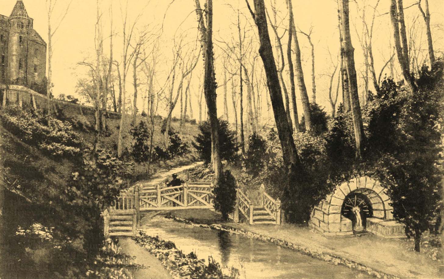
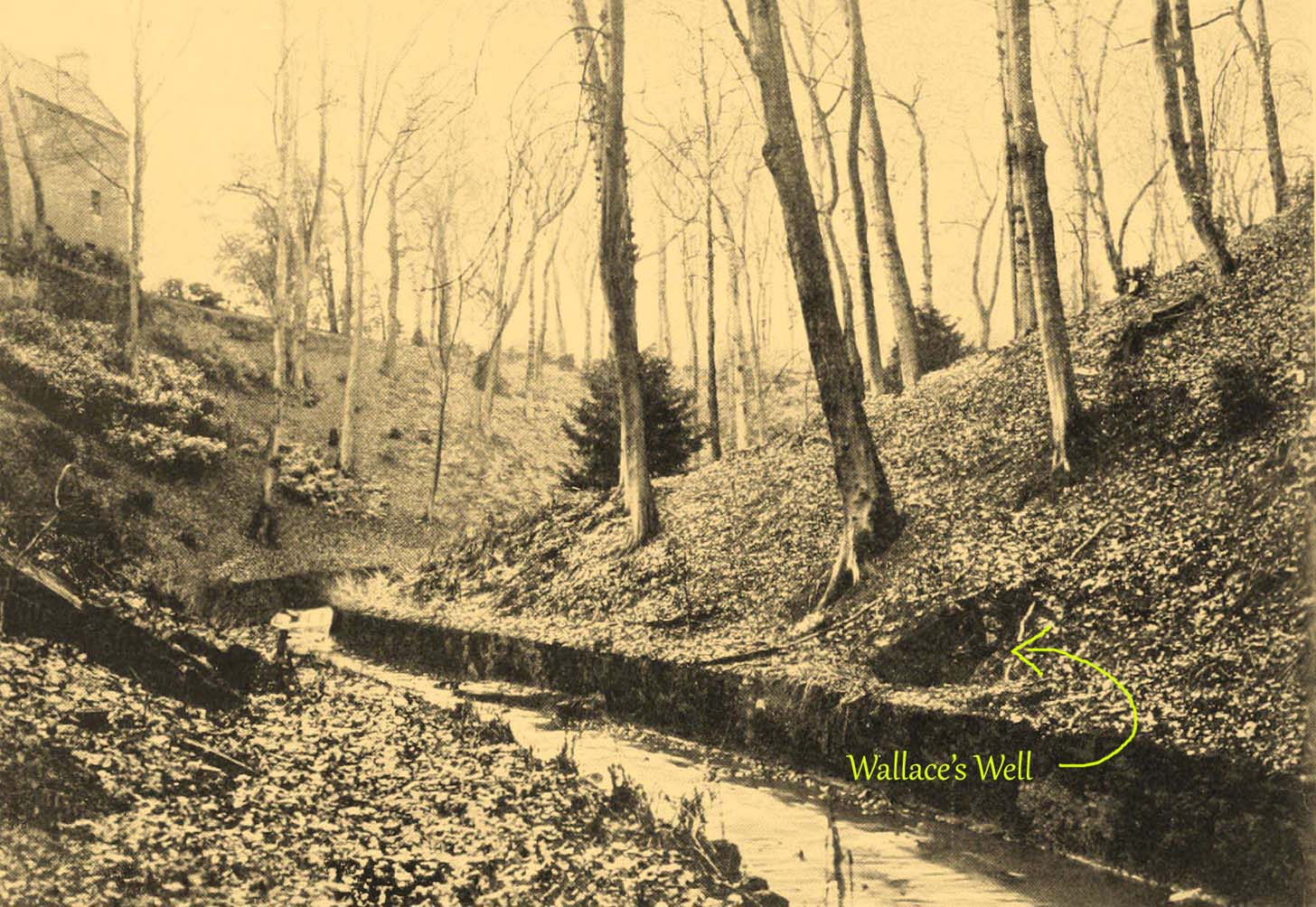
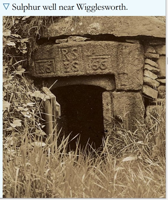
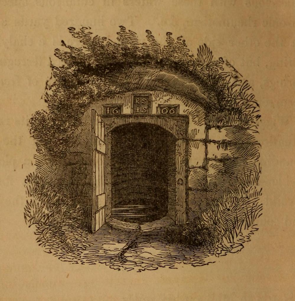
In William Addison’s (1951) standard work on the history and development of Spa Wells, he told us that “the spas began as holy wells”; yet in spite of him listing the Wigglesworth Spa in his work, such “holiness” wasn’t a feature found here and, sadly, we have no written records that tell of any. But that doesn’t mean to say it had no sense of importance or animistic sacrality to local people. The earliest written record we have of this Sulphur Well is to be seen on the stone-work at the top of the small well-house, where the year “1666” was carved, marking the year when the structure was built under the directions of a local rich dood. But earlier knowledge of these healing waters would have been passed to the land-owner by local people, as indicated in Thomas Short’s (1765) words where he told that “it has been used time out of mind.”
Mr Short (1724) makes mention of this Sulphur Well in his gigantic early work, but only in its similarity in both taste and smell to the Sulphur Well at Harrogate and letting us know that, “I have tried carefully” the waters of the two sites. We had to wait another forty years before he gave us a more detailed account of the medicinal properties here. He wrote,
“Now come we to a sulphur water of a very peculiar nature, such as I never met with or heard of in England besides, and deserves to be much more strictly examined and enquired into, viz. Wigglefworth Spaw, near Settle, in the parish of Long-Preston. It has been used time out of mind, and more formerly than at present, because it is little known; rains and drought affect it not. Country people drink four or five pints of it in a morning to vomit them, and six or seven pints to purge them. The water is very black, smells strong of sulphur, has a very small stream, but stagnates not, bubbles not, but springs up; it is always covered with a white scum, (and) dies all in its course white. It rises out of a great stone soil, near much lime-stone, at the foot of a hill. It tastes salt, yet curdles not soap, and boils with milk. A phial glass, one third part full of it, well corked, and tied down with a bladder, and set in the cold water to be evaporated; when the water began to boil, it was taken out and poured a little of it on solution of silver, which turned black and curdled. The phial was corked again, and set half an hour longer in the boiling water, it still turned solution of silver black. It was corked a third time, and set half an hour longer in the boiling water, then tried, but was not so black as before, and caused little curdling. This last stood all night, next day its precipitation was blackish; the water was clear above. This is the only blackish sulphur water I have met with (as Rippon is a greenish yellow) and retains its sulphur the longest, from its contained oil.”
Consistent with other writers of his time, Mr Short then wrote at length on how the Wigglesworth waters reacted to various chemical tests, many of which were done in order to indicate the veracity, or otherwise, of any medical qualities. He also made comparative studies between this and the sulphur wells at Harrogate and elsewhere, and concluded that the Wigglesworth Spa would successfully deal with the following ailments or conditions:
“Sloth, idleness, too violent slavish exercise or labour, too great affluence, or plenty of nourishing rich high foods, spices, forced meats, acrid, stimulant and aromatic viands; the earthy viscid dregs of fermented liquors, or the parching, drying, shriveling spirits of wine, sugar, fruits, grain, or fermented liquors, as well as poverty and unwholesome diet, irregular hours, etc, are the parents of many diseases, whose cure lies in relieving oppressed nature from the unwieldy load (brought upon her by indolence, gratifying the vitiated taste, intemperance and debaucheries) by cleansing and rousing the vessels, restoring the juices to a healthy state; rectifying and establishing the secretions and excretions of the body, and restoring vigour and activity to the fibres, vessels and solids. To the above causes of diseases, we may add pride, luxury, sensuality, inverting the natural course of time, turning day to night, and night to day. These give birth to many chronic diseases, as well as acute, from acidities, crudities, viscidities in the stomach, communicated thence to the bowels, and so to the whole habit; hence are vitiated juices, great obstructions, and a long train of diseases affecting sundry parts of the body, and therein the whole nervous system, with hypo, hysterics, melancholy, costiveness, or looseness, suppression of natural necessary discharges, etc., which require thinning, relaxing, resolving, opening, or invigorating remedies.”
For about two centuries this well had a very favourable reputation. It’s therefore slightly curious as to why the great spa-writer, A.B. Granville, in his visit to this part of Ribblesdale to seek out some of the medicinal springs in the 1830s (including a petrifying well), made no mention of our Sulphur Well. Whether this was due to his patronizing attitude towards local people isn’t known, but it certainly wouldn’t have helped him in Yorkshire! One might suggest it was due to the fact that the spa had fallen into disuse, but this wasn’t the case because, subsequent to Granville’s visit, the local writer William Howson (1850) later told us that,
“In the woody dingle to the north of the village is a sulphurous spring, protected by a neat and antique stone canopy bearing the date 1666, and the initials of Sir Richard Sherburne and Isabella his wife, a daughter of John Ingleby of Lawkland Hall. Of this well, Dr (John) Murray the well-known analytical chemist says, ” It is a most valuable and unusually strong sulphuretted water, and as far as I have examined mineral waters, second to none.” From his analysis and that of Dr. Garnett it appears that a gallon of the water contains seventeen cubic inches of sulphuretted hydrogen, four of azote, and a small portion of carbonic acid, sulphate of magnesia in the proportion of seventy five grains to a gallon, a considerable quantity of muriate of soda, and a minute proportion of carbonate of lime.”
(The aforementioned Dr Garnett was a renowned 18th century authority on medicinal wells in Yorkshire, best known for his works on the spa wells of Halifax (1791) and Harrogate (1791, 1792), along with some in Scotland.)
Messrs Short (1765) and Howson (1850) mentioned other medicinal springs very close by, including the Chalybeate Well in the field immediately north on the other side of the stream.
References:
- Addison, William, English Spas, Batsford: London 1951.
- Brown, G.H., Walks, Drives and Excursions around Settle, Craven Printing: Settle 1880.
- Howson, William, An Illustrated Guide to the Curiosities of Craven, Whittaker: London 1850.
- Short, Thomas, The Natural, Experimental and Medicinal History of the Mineral Waters of Derbyshire, Lincolnshire and Yorkshire, privately printed: London 1724.
- Short, Thomas, A General Treatise on Various Cold Mineral Waters in England, privately printed: London 1765.
- Anonymous, Water for Life, North Craven Building Preservation Trust 2010.
Acknowledgements: Many thanks to the North Craven Building Preservation Trust for use of their photo.
© Paul Bennett, The Northern Antiquarian