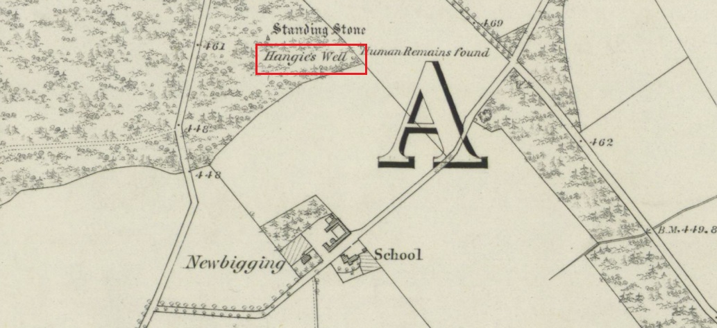
Turn right off the A93 at Cargill onto the side road by Keepers Cottage and up the hill to Gladsfield Wood at the top on your right. Park up at the top side of the Wood and walk straight along the narrow track for around 450 yards until you get to where another track crosses it and turn left along this track and head for the electricity pylon. The well is immediately to the left (north-east) of the pylon.
Archaeology & History
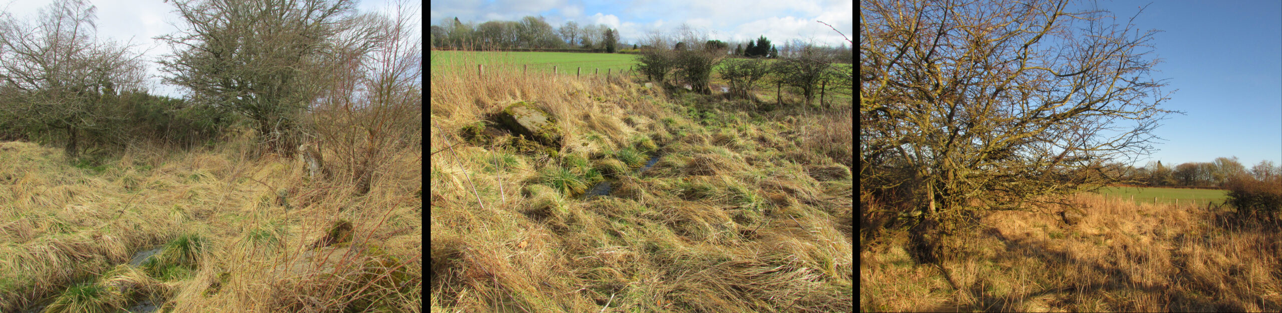
On my first visit I got the impression this weed-choked pool may once have been a holy well. There are stones on the north east side of the pool, some of which look to have been shaped, which may have formed part of a walled enclosure or part of the adjacent Roman road; or they may only be field clearance boulders. There is the tell-tale gnarled hawthorn tree with the thick stump of a what has been a much larger hawthorn next to it. And folklore of a hangman to explain the ‘Hangie’s’ name.
Andrew Jervise, writing in 1863, told that,
“About three hundred yards from the Parish schoolhouse, an old well, now partly filled up, Hangie’s Well, near which, it is said, the parish hangman dwelt, and where, some fifty or sixty years ago, a quantity of human bones were discovered”
But what was going on here before this hangman stalked the land? The well—a spring actually—is at the top of the ridge above the Tay beside the Muthill to Kirriemuir Roman road (the most northerly Roman road in the Empire apparently, says Ivan Margary), and so would have been a welcome stopping point for men and horses using that road; and this being the Roman Empire, the well may have acquired some cultic significance.
In the mediaeval period the Cistercian monks of Coupar Angus built their own Abbey Road adjacent to the well which went from their Tayside estate at Campsie to the Abbey, and which would again have been a welcome stopping point for monks and pilgrims. In the parish there was a local cult of a St Hunnand, this name being thought to be a corruption of Adamnan (and if Adamnan can be corrupted through oral tradition to ‘Hunnand’ then Hunnand can be corrupted to ‘Hangie’?). If this was once a holy well that continued to be venerated after the Reformation, did the wily Presbyterians ‘taint’ it by coming up with a tale of an executioner using it to wash the blood of his victims off his hands? But enough of this speculation, in the absence of proof it must just remain plain old Hangie’s Well! When you’re in the area, give it a look and see what you think.
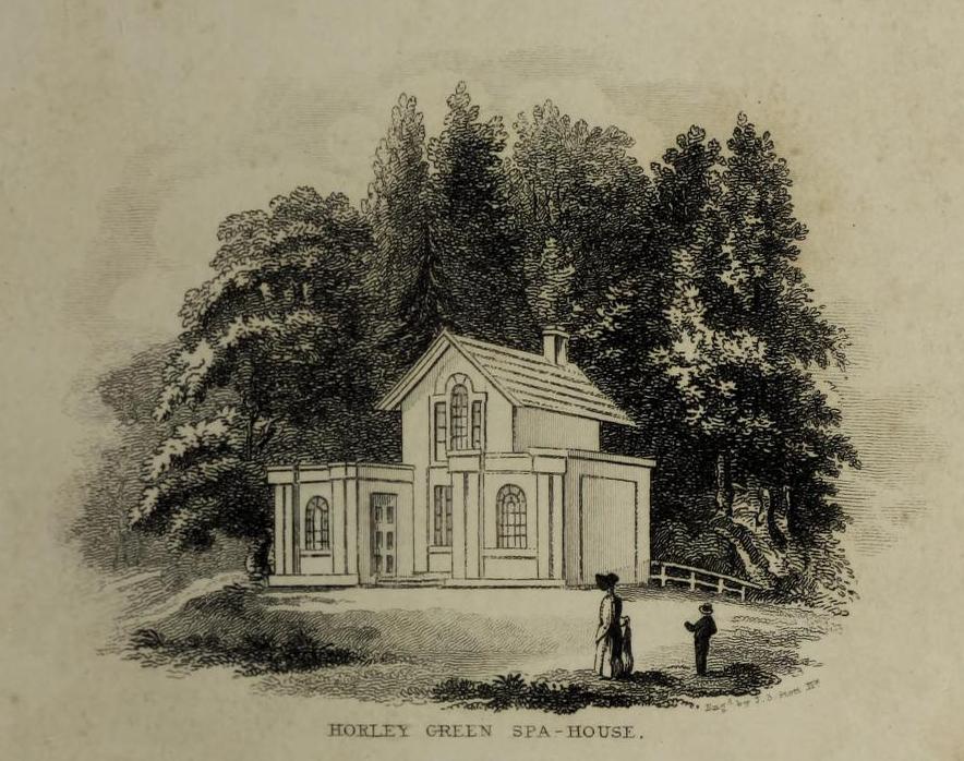
The Well showing the adjacent stones and the Hawthorn bush.
Folklore
This story was given by the locals to the Ordnance Survey inspectors around 1860:
‘A small well a little to the south west of Gallowhill. According to the tradition of Mrs. Manson & Boyd the Executioner made use of this well for washing his hands after he had performed his duty towards criminals that were condemned to be executed on Gallowshade.’
William Rose writing in the New Statistical Account of 1845:
‘Near the Village of Gallowhill is a field called the Gallowshade, which was a place of execution under the feudal system. And in a field about 100 yards north from the school house is a well, said to have been used by the executioner for washing his hands after being engaged in his bloody work, and which still goes by the name of “Hangie’s Well.”‘
Acknowledgements: Big thanks for use of the 1st edition OS-map in this site profile, Reproduced with the kind permission of the National Library of Scotland.
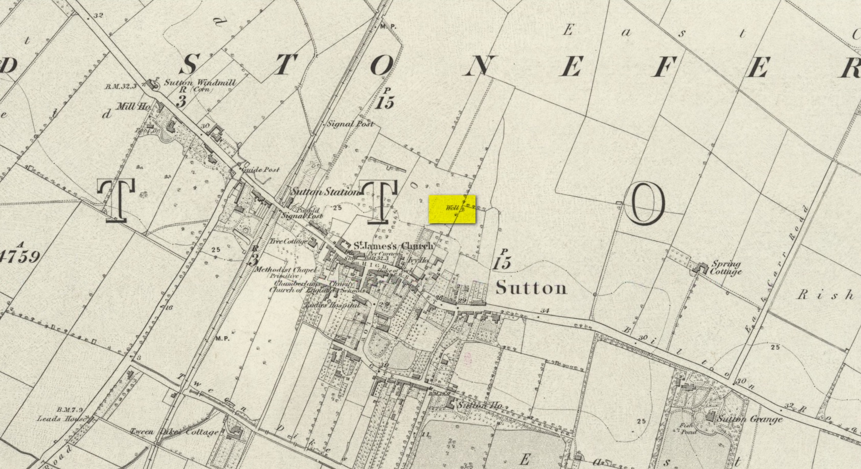
We don’t know for certain the precise whereabouts of this long lost healing well, but it would seem to be the one highlighted here (right) on the 1855 OS-map. However, I think it equally possible that the small unnamed building, roughly halfway between the highlighted ‘Well’ and Spring Cottage, where the walling meets, could be the site in question. It’s one or the other!
Folklore
When Thomas Blashill (1896) wrote of the Blind Well in his standard history work of the area, memory of it was already falling away. In discussing where local people could wash and look after their health, he told that
“There was one place in the parish where washing seems to have been practised as a curative measure. Down in the East Field, near to Spring Cottage Farm, was the Blindwell, to which the people had access. If they used its waters freely when suffering from sore eyes, their faith would probably be rewarded.”
Holy Well (destroyed): OS Grid Reference – SJ 836 985
Archaeology & History
Long since lost beneath the metal and concrete of modern times, even references to this forgotten place are very faint indeed. I expected to find something of it in Henry Taylor’s (1906) giganteum, but it even slipped through his considerable work; and, even where mention of it exists, it is only in passing. In William Proctor’s (1874) survey of early Manchester, he found deeds relating to the land and its early owners wherein the one and only mention of this well appears. It was located near the middle of the city centre, between the Law Courts and Manchester cathedral, in the area known today as the Parsonage Gardens on the east-side of the River Irwell. In earlier centuries this was the abode of a Christian minister, or parson, and the water from this well supplied his religious abode. Proctor wrote:
“Crossing over to the Parsonage, we find that, in 1780, one of its residents was Mr John Quincey, linen-draper, uncle to the English Opium-Eater. In the previous year Mr Quincey was married to Miss Martha Goodyear, of Ardwick. His residence was bounded, it seems, on the north and west by “a narrow street or passage called Black Fryars”; while on the other points of the vane his prospect is thus shown by an extract from a lease dated 1758: — “The orchard or garden plot adjoining the river; it is now fenced out with hedges and ditches.” Some years earlier mention is made of a summer-house, fruit trees, and plants in abundance, with “free liberty of way to the spring or well called the Parsonage Well.” In 1686, Thomas Heyrick of Manchester, gentleman, leased a “tenement and parcel of land abutting upon a messuage and garden heretofore in the possession of George Tipping, deceased, and now the dwelling-house of the warden [Richard Wroe] of the said College; bounded on the east part with the old Parsonage ditch adjoining to the tenement of Mr John Oldfield. Close by are or were the residences of John Nield, Hugh Boardman, Richard Haworth, Esq., and lately Jane Haworth, his widow.” A worn parchment proves the existence, in 1698, of “Parsonage Croft;” another of “Parsonage Pool;” and an order of the Court Leet, 1594, required the tenants to “go along the hedge-side, keeping the footway towards the Parsonage style, for their fetching of water from the river.” In 1765, an advertisement in the Mercury mentions “the sign of the Grey Horse in or near Parsonage Brow.” St Mary’s Church covers the ground once known as the Parsonage Green.”
The site of the well, which was in the historic county of Middlesex, appears to have been on the west side of the present Moorefields Road just north of the junction with St Loy’s Road. The OS reference is an approximation. The restored circular well house to the south of the High Cross at the High Road – Philip Lane junction now popularly known as ‘The Old Well’ or ‘The Old Pump’ by Tottanham Green has been referred to as being ‘St Eloy’s Well’ but this is not the historic well described in this profile.
Archaeology & History
Likely position of the well on the 1873 6″ OS Map
The well was still in existence in 1876, but by the time of the revision of the OS map around 1894, it had been destroyed following building of the Great Eastern Railway’s Enfield branch line and the construction of terraced housing along the new St Loy’s Road.
So where was the well? The 1873 6″ OS map shows a field on parts of which the railway line and St Loy’s Road are now built, and a small area of water is shown in this field which is the likely position of St Loy’s Well on the eve of its destruction, when it was described as a dirty pool of water full of mud and rubbish. If this was the position of the well then it has now been completely built over…
It was described by Robinson in his 1841 History of Tottenham as being:
‘..in a field….on the western side of the High Road…surrounded by willows…it is bricked up on all sides, square and about 4 feet deep..’ ‘ In Bedwell’s time [it was]…always full of water, but never running over; the water of which is said to exceed all other near it.’.. ‘the properties of the water are similar to the water of the Cheltenham springs’.
Thomas Clay ‘s 1619 map of Tottenham, illustrated in Robinson’s book shows a field north west of Tottenham High Cross called ‘Southfeide at St Loys’. The Tottenham historian Wilhelm Bedwell described the well in 1631 as:
‘“nothing else but a deep pit in the highway, on the west side thereof;”….”it was within memory cleaned out, and at the bottom was found a fair great stone, which had certain letters or characters on it; but being broken or defaced by the negligence of the workmen, and nobody near that regarded such things, it was not known what they were or meant.’
This fair great stone with its ‘certain letters or characters that no one knew what they were or meant’ is intriguing especially in view of the well’s proximity to the Roman Ermine Street (Now the High Street). Were those mysterious characters spelling out an undecipherable Latin inscription on a Roman stone? We shall never know, but it hints at a pre-Christian origin or veneration of the well. Another hint is that before the Reformation there was nearby a chapel of St Eloy known as the Offertory*, which may have been originally built to ‘Christianise’ a pre-existing heathen sacred spring. The Roman origins of the well are also hinted at (probably erroneously) by W.L. Bowles in 1830, writing of a ‘Druidical Tour’ that one Sir Thomas Phillipps undertook on the continent, first quoting Phillipps before adding his own conclusion:
‘“Near Arras in France, are found the mount of St. Eloi and the very name of a place, Tote. I have no doubt Druidical remains will be found there, if this be not the very country of Carnutes.”
Now let me observe, that Tote is Taute —Tot—Thoth, latinized into Tewtates by Lucan, &c. the chief deity of the Celts. St. Eloi is neither more nor less than the Celtic word Sul, turned into the Greek the Sun; and Elios, turned into the Catholic St. Eloi, as at Tottenham, Middlesex, anciently Tote-ham, the ham of Taute or Tent, where is also the sacred well of St. Eloi, or ‘Helios’, the Sun !’
Saint Eloi / Eloy /Loy / Eligius, is the patron saint of those who work in the alchemists’ metal of the sun – goldsmiths! He is also the patron saint of blacksmiths, farriers, and all who earned their livings from horses, and lived from around 588 to 660 to become Bishop of Noyon and the evangelising apostle for much of modern day Belgium. His feast day is 1st December, and he had a widespread cult in mediaeval Europe, including England. In addition to being a healing well for humans, one writer hints that the well’s waters may have been employed for healing horses…they certainly would have drunk from it with its proximity to what is now the High Street.
Around 1770, an artist called Townsend (the sources are unsure as whether it was a Mrs or Mr) produced a romanticised drawing of the well, which was exhibited at the Royal Academy in 1770-1. It depicts a hermit beside the well (the Hermitage of St Anne stood to the south of High Cross prior to the Reformation) receiving an offering from a lady. It was engraved and sold as a print, and may be the only image of the well before its demise.
Folklore
In 1819 – 20, John Abraham Heraud wrote a poem about St Loy’s Well, set in the time of St. Edward the Martyr, (the late 970s), entitled ‘ Stanzas in the Legend of St Loy‘ of which the most relevant verses are;
‘TOTEHAM! the Legend of thine olden day, To the last note hath on thine echoes died; But the Bard’s soul still lingers o’er the lay, To muse upon thy transitory pride The pride of times that hath been — blank and void— When all was Nature, big with many a song Of Chivalry and Fame, with Love allied— But Time both changed the scene — now houses throng Where once was solitude — and people crowd along.
Where now thy WOOD, that spread its misty shade O’er twice two hundred acres? — past away! And vain its PROVERB, as the things that fade, Earth, sun, moon, stars, that change as they decay! The lonely CELL, the tenor of the lay, Its grove, which hermit tendance loved to rear; And, St. LOY, mouldering to Time’s gradual sway, Thy rites, thy OFFERTORY disappear;— Forgot thy SPRING OF HEALTH no votary worships there!
Forgot, neglected — still my harp shall dwell On thee, thou blest BETHESDA of ST. LOY! As Fancy muses o’er the vital WELL On years of storied yore, with grief and joy, Exults they were — weeps Truth should e’er destroy! Thrice I invoke the Spirit of the Stream With charm she may not question, or deny, And, like a Naiad, o’er the watery gleam She rises to my voice, and answers thus the theme:— ‘
Heraud wrote a further poem mentioning the well, his ‘Tottenham‘ of 1820, the relevant verse being:
‘St. Loy! here is this fountain—emblem pure Of chaste unostentatious charity— Never in vain intreated, ever sure ; Yet o’er the marge thy waters fair and free Ascend not, overflowing vauntingly, But in thy bounty humble as unfailing, In grief, disease, and sickness, visit thee. But part in joy, changed by thy holy healing To manhood, strength, and life, thy far renown revealing. There is thy offertory, and thy shrine, Simple, inartificial ; nor of fame, Nor any honour, save that it is thine, And all its glory centres in thy name !’
*Footnote – Brian Spencer’s book on mediaeval pigrim badges recovered by archaeologists in London refers (p222) to a distinct ‘London pattern’ of St Eloi badge – is this a hint that the Offertory was a local shrine to St Eloi where such badges were sold to pilgrims? Further research is needed to try to verify this speculation.
The historian William Addison (1951), in his history on the subject, told how “the spas began as holy wells”; and although no direct accounts are left of early dedications here, the remnants of Mayday traditions tell us there were more archaic goings-on before the waters were taken by the aristocrats. Once it had been designated as a spa, the waters were covered and a typical Spa House constructed over them. From hereon, for more than a century, the waters were accessible only to those with money who wished their ailments to be treated.
Between the end of the 18th to the end of the 19th century, the Horley Green Spa was a very prominent ingredient in the history of Calderdale. A chalybeate or iron-bearing spring, its waters were directed into a large underground cistern covered by metal. Thomas Garnett (1790) was the first to write about it, telling us:
“The Horley Green water is quite pellucid—sparkles when poured out of one glass into another—and has a sharp, aluminous, styptic taste, not unlike ink. The taste is not unpleasant when the water is taken from the springhead and drank immediately.”
He went on to espouse the waters to be good in healing bone and rheumatic diseases, giving many first-hand accounts from people in Yorkshire and beyond who used the waters here with apparent success, including one case of curing diabetes! Its reputation was later reinforced in a book by William Alexander (1840), who told us how,
“I unhesitatingly affirm that the Horley Green Spa possesses a very strong claim to be regarded as a powerful tonic and chalybeate.”
By the time those words were written, it had already gained a considerable reputation and many were those who’d received treatment.
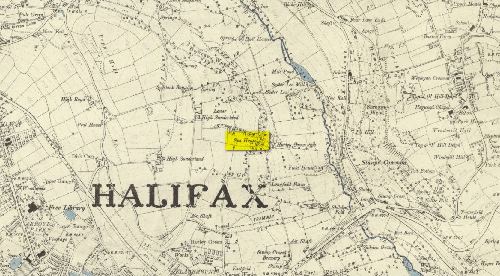
Spa House on 1894 map
A years after Alexander, the roving doctor A.B. Granville (1841) visited Horley Green—who described it as “a renowned steel-water Spa”. But at the same time he reported how its popularity had started to decline. But, via one Mr West, he did leave us with a greater chemical analysis of the Horley Green waters in an attempt, once more, to certify and prove its curative properties. Their results found the waters to possess, in varying quantities, lime, magnesia, silica, iron oxide, sulphur and silica—all of which further attributed the science of its medicinal actions. A number of case histories of the people cured here can be found in the works of Granville, Garnett and Alexander.
The well-house that stood here eventually fell into disuse. When it was eventually restored as someone’s home in the the late 20th century, the disused spring was found beneath the foundations, filled with stones.
Folklore
Horley Green’s spa well came about as a result of local people visiting the site around Beltane, probably for centuries before the aristocrats and early pharmacists took their hand to the place. But once the spa became renowned, people could only gather here “on the first Sundays in the month of May,” with Sunday being that legendary ‘day of the lord’ crap, to which the people would abide to save them from prosecution. It is obvious though that it had been used as a place of magick thanks to the snippets of lore which have found their way into local history books. We read how, at 6am, people gathered here, to such an extent that the roads were completely crowded. Those who arrived first were given bags of nuts: an archaic traditional motif found at many pre-christian wells in Britain. Occultists and ritual magickians amongst you will note the time when folk frequented the well, at 6am: the time when many nature-spirits are invoked for full effects. We find this time echoed in the ritual gatherings at Lady or St. Anne’s Well in Morley, just a few miles to the east.
References:
Addison, William, English Spas, Batsford: London 1951.
Alderson, Frederick, The Inland Resorts and Spas of Britain, David & Charles: Newton Abbot 1973.
Alexander, William, “On the Mineral Springs of the Parish of Halifax,” in Proceedings Geological & Polytechnic Society, West Riding, Yorkshire, volume 1, Edward Baines: Leeds 1849.
Crabtree, John, Concise History of the Parish and Vicarage of Halifax, Hartley & Walker: Halifax 1836.
Granville, A.B., Spas of England, Henry Colburn: London 1841.
Hembry, Phyllis, The English Spa 1560-1815, Athlone Press: London 1990.
Short, Thomas, The Natural, Experimental and Medicinal History of the Mineral Waters of Derbyshire, Lincolnshire and Yorkshire, privately printed: London 1724.
Short, Thomas, A General Treatise on Various Cold Mineral Waters in England, privately printed: London 1765.
Approaching the site from the north, walk along the Lane Head track, and along the path south-eastwards, then turn right onto the main footpath until coming to the stream. Follow the stream up the fell to the large clump of reeds, then follow your ears until you locate the spring! Or you can approach it along the main footpath from the Oakenclough – Galgate road. The well and the path to it
are on access land.
Archaeology & History
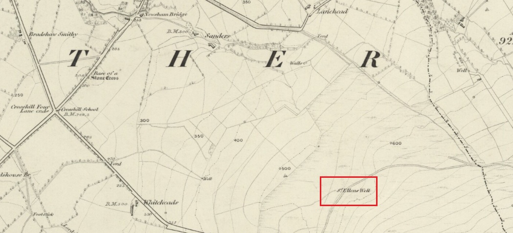
Fortunately recorded by the Ordnance Survey on their 1846 6″ map Lancashire XL, the story of St Ellen’s Well was taken up sixty years later by local holy wells historian Henry Taylor (1906):
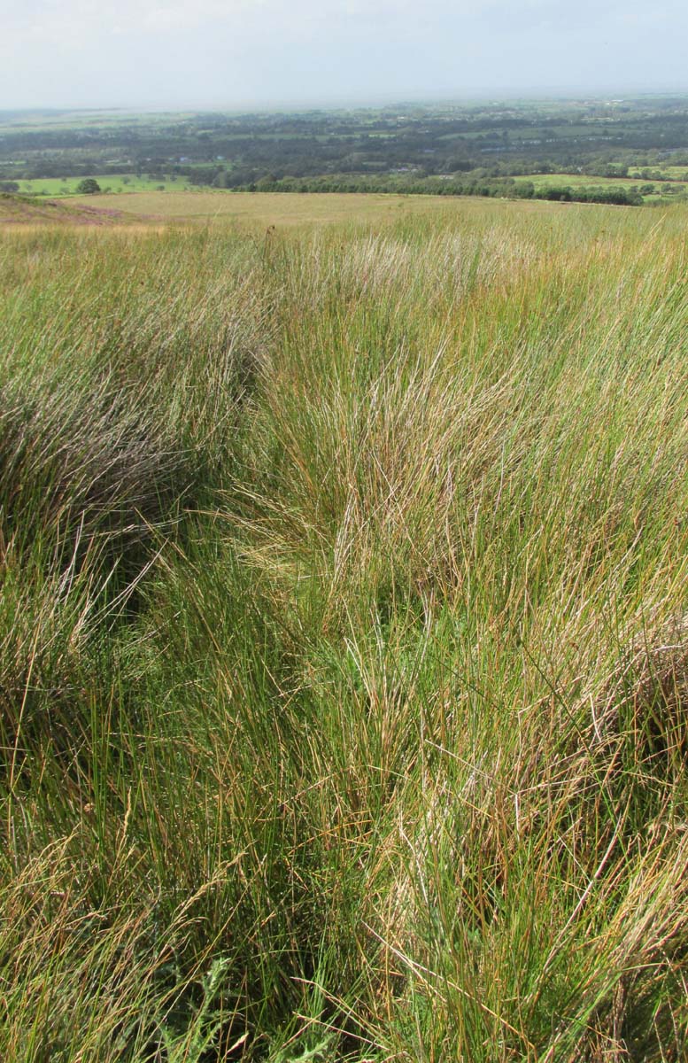
Listen for the spring in the reeds
“The site of this holy well is marked on the ordnance map at a lonely spot on Harris Fell, five hundred feet above the sea-level, four and a half miles in a north-easterly direction from the town of Garstang.
“Mr. A. King has kindly examined the site. He writes, 4th August, 1902: “We had no difficulty in locating the spot…. There is no outward indication of the place being used for curative means, and there is no stonework at all. It is a beautifully cold spring which is at the side of ‘Bonny Pad’, a pathway leading across the moor from Harris End, and it was grown around with rushes…. All I can glean about it is that one of the oldest inhabitants, when asked if he knew of it, replied, ‘It will be th’ holy well, you mean.'”
The original dedication of this remote holy well was clearly to St. Helen, and its presence next to the Bonny Pad or path may indicate a pre-Christian dedication to a local cognate of the Celtic Elen Luyddog, Elen of the hosts or ways. The Bonny Pad is shown but not not named on the 1846 map, and follows a broadly southwest to northeast direction from Harris End (again not named on the 1846 map) up to Grizedale Head on the southern edge of the Catshaw Vaccary. It was perhaps an ancient route used by farmers to take their animals up onto the fell for the summer, and return them to the lowlands in the autumn.
Bubbling away at source
The western portion of Bonny Pad is not shown on the modern map and St Ellen’s Well is not marked, and both have it seems passed out of local memory. An elderly farmer I encountered on my way up to the fell had never heard of the Well.
It is certainly worth the walk if only for the delightful sound of this powerfully flowing spring, the water is pure and cold, and it commands a fine view over the Lancashire plain to the coast.
References:
Taylor, Henry, The Ancient Crosses and Holy Wells of Lancashire, Sherratt & Hughes: Manchester 1906.
Wise, Caroline, “Elen of the Roads of Country and Town”, in Finding Elen – The Quest for Elen of the Ways, edited by Caroline Wise, Eala Press: London 2015.
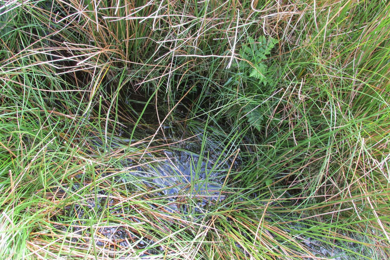
From East Morton village, take the moorland road, east, and up the steep hill. Where the road just about levels out there’s a right turn, plus (more importantly!) a trackway on your left which leads onto the moor. Walk up this track for ⅔-mile until you get to the point where the moorland footpath splits, with one bending downhill to an old building, whilst the other smaller footpath continues on the flat to the north. Go up here for 400 yards then walk off-path, right, for about about 150 yards. But beware – it’s boggy as fuck!
Archaeology & History
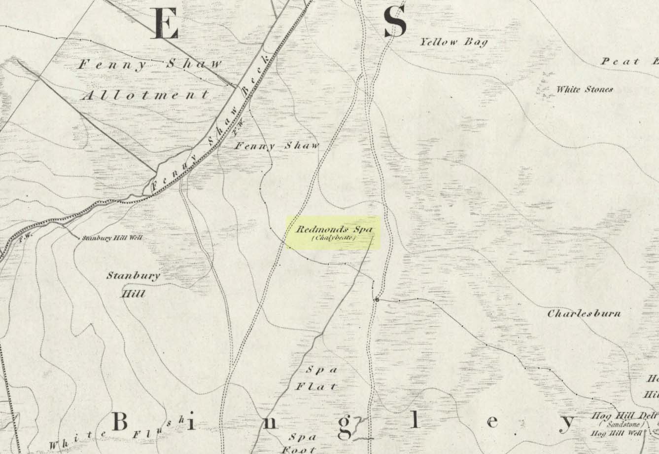
On this featureless southern-side of Rombalds Moor, all but lost and hidden in the scraggle of rashies, a very boggy spring emerges somewhere hereabouts. I say hereabouts, as the ground beneath you (if you can call it that!) is but a shallow swamp and its actual source is almost impossible to locate. If you want to find the exact spot yourself, be prepared to put up with that familiar stench of bog-water that assaults our senses when we walk through this sort of terrain. Few are those who do, I have found… But somewhere here, amidst this bog—and still shown on the OS-maps—is the opening of what is alternatively called Redman’s or Richmond’s Spa. We don’t know exactly when it acquired its status as a spa-well, but the 18th century Halifax doctor, Thomas Garnett—who wrote the early work on the Horley Green Spa—appears to be the first person to describe it. Garnett (1790) said how the place:
“was first mentioned to me by Mr W. Maud, surgeon, in Bradford, who went with me to see it. It is situated on Romalds-moor, about two or three miles from Bingley, and goes by the name of Redmire-spaw. The access to it is by no means good; the ground about it being very spongy and soft. On the bottom and sides of the channel is deposited an ochrey matter, of a very fine, bright, yellow colour; and which I believe is used, by the country people in the neighbourhood, to paint their houses. It sparkles when poured into a glass and has a taste very like the Tewit-well at High-Harrogate; which water it very much resembles in all its properties, and seems to be about the same strength… This water seems to hold a quantity of iron dissolved by means of fixed air. Its taste is very pleasant; it is said to act very powerfully as a diuretic, when drank in considerable quantity, and may prove a useful remedy, in cases where good effects may be expected from chalybeates in very small doses; the fixed air, and even the pure water itself may be useful in some cases. It is, however, necessary to drink it at the well, for it seems to lose its iron and fixed air very soon.”
I’ve drank this water, and believe me!—it doesn’t quite taste as pleasant as Mr Garnett espouses! Its alright I s’ppose—but drinking water from a bog isn’t necessarily a good idea. That aside, I find it intriguing to hear so much lore about such a little-known spring; and it is obvious that the reputation Garnett describes about this spa came almost entirely from the local people, who would have been visiting this site for countless centuries and who would know well its repute. Below the source of the well the land is known as Spa Flat, and slightly further away Spa Foot, where annual gatherings were once held at certain times of the year to celebrate the flowing of the waters. Such social annual gatherings suggests that the waters here were known about before it acquired its status as a spa—which would make sense. The remoteness of this water source to attract wealthy visitors (a prime function of Spa Wells) wouldn’t succeed and even when Garnett visited the place, he said how he had to travel a long distance to get here.
The origin of its name was pondered by the great Harry Speight (1898) who wondered if it derived from the ancient and knightly Redman family of Harewood, whose lands reached over here. But he was unsure and it was merely a thought. As an iron-bearing spring (a chalybeate) you’d think it might derive from being simply a red mire or bog (much like the Red Mire Well at Hebden Bridge), but its variant titles of apparent surnames casts doubt on this simple solution.
No one visits the place anymore. Of the countless times I’ve wandered the moors, rare have been the times when I’ve seen folk anywhere near this old spring. It is still coloured with the same virtues that Garnett described in the 18th century: the yellowish deposits, the boggy ground, much of which reaches to the truly dodgy Yellow Bog a short distance north and which should be completed avoided by ramblers after heavy rains (try it if y’ don’t believe me—but you’ve been warned!).
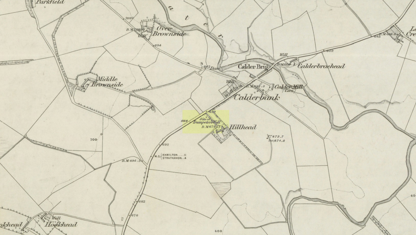
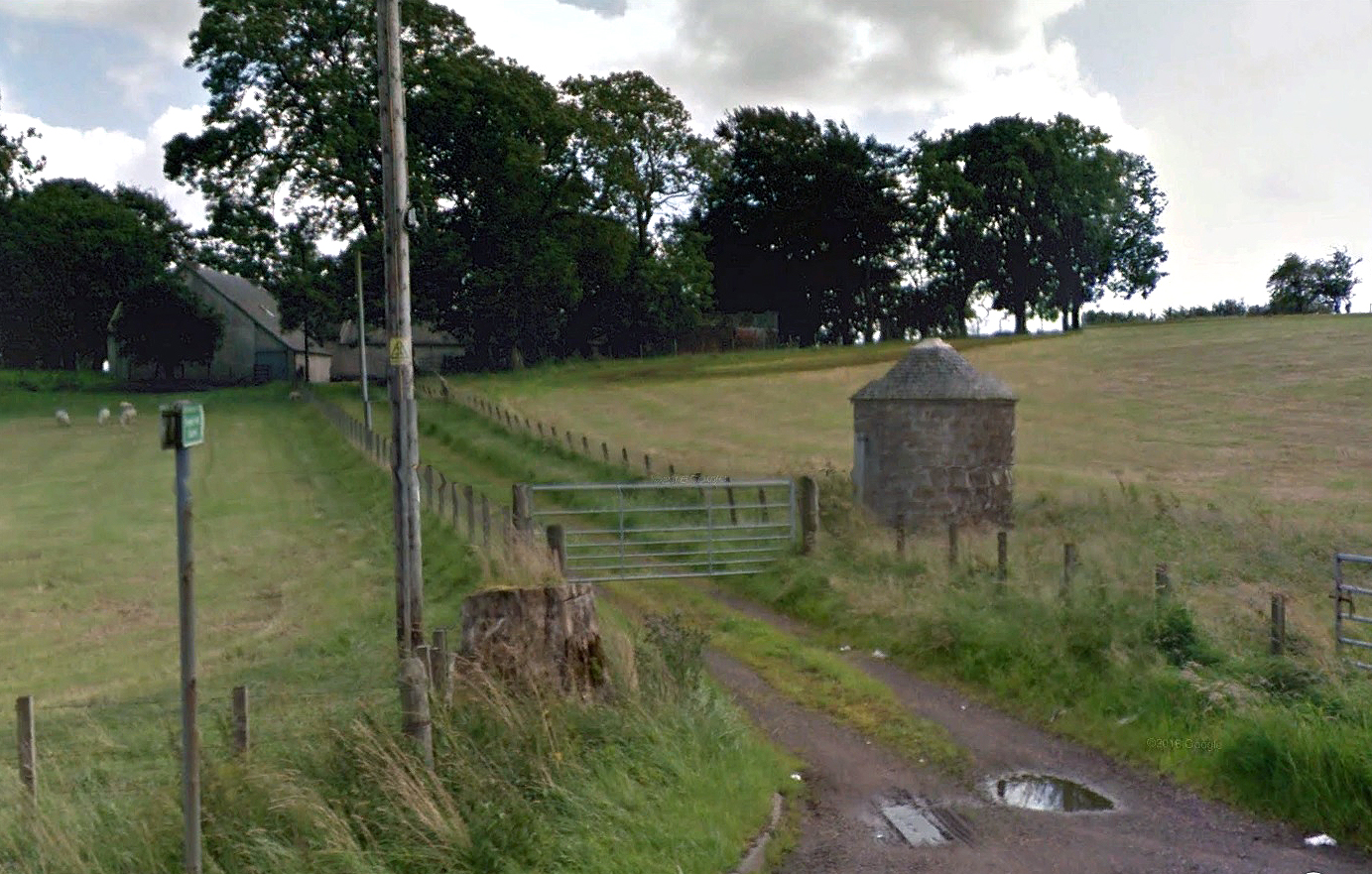
Take the A71 road southwest out of Strathaven as if you’re heading to Kilmarnock. After 2½ miles (4.1km) you reach the tiny hamlet of Caldermill (be careful or you’ll truly miss it!). As you go out of the hamlet, on your left there’s a track up to Hillhead Farm with the small but tell-tale signpost saying ‘Trumpeter’s Well’ and the small dome-shaped stone monument in the field is what yer looking for. If you’re coming from the Kilmarnock side, when you reach the Caldermill sign, it’s in the field immediately to your right. Y’ can’t really miss it.
Archaeology & History
When the site was surveyed by the Ordnance Survey lads in the 1850s, the water supply had completely run dry. It was later revived and the nine-foot tall circular stone building built to commemorate its history. The water apparently now runs within the building, being supplied from Hillhead Farm.
Trumpeters Well, Caldermill
Folklore
The well is said to have gained its name after the local Battle of Drumclog (1679), when one rich Tory known as John Graham of Claverhouse was retreating for fear of his life; and because his own horse had been killed, the coward stole the horse of his young fourteen-year-old trumpeter. In doing so, the young lad was subsequently killed and his body was thrown down the well. Tradition also tells that other soldiers were buried in the same field.
References:
Campbell, J. Ramsey, My Ain, My Native Tour – Stra’ven, J.M. Bryson: Strathaven 1943.
Whichever way you come into the hamlet—be it along the A911 from either Milnathort or Glenrothes, or up the B920 from Ballingry side—the only little carpark to use is about 20 yards from the main road junction, on the west-side of the road, appropriately named Well Road. The site is unmissable beneath the small well-house at the end of this short cul-de-sac.
Archaeology & History
When a village is named after a well, you know that its waters held some considerable importance! Mentioned as early as 1218 as “de fonte Scotie” and subsequently many variations thereof in centuries thereafter, the place-names authority Simon Taylor (2017) thinks it may have been mentioned as early as 1090 CE.
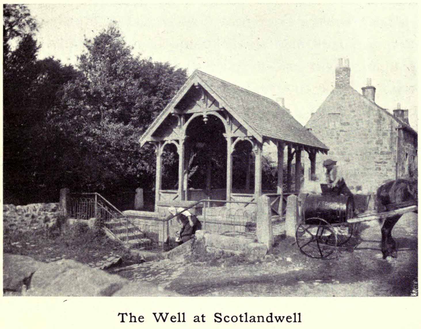
Scotland Well in 1915The clear cold waters
Although there has never been a direction dedication of the Scotland Well to any saint, as J.M. MacKinlay (1904) and others have pointed out, in the village itself was an ancient medieval hospital that belonged to “the Trinity or Red Friars” that was built for the benefit of the poor by the Bishop of St. Andrews, some 22 miles to the east. The hospital was at first dedicated to St. Thomas and subsequently to the Virgin, or St Mary. Holy wells dedicated to both saints are renowned the world over as having great medicinal properties, but no extant written document relates either saint to the well.
Folklore
The main reason for this site maintaining such an honourable place in Scottish history is its association with the two great Scottish heroes, Sir William Wallace and King Robert the Bruce. In the pseudonymous Historica’s (1934) literary rambles, he told that, after coming down out of the Lomond Hills,
“We descend the narrow defile—the Howgate—into Scotlandwell—Fons Scotia—famous for its medicinal springs, where tradition says King Robert the Bruce came to take the waters for scrofula and leprosy in 1295. The great Sir William Wallace—according to ‘Blind Harry’—also has associations here. His famous swim to the Castle Island, for a boat to take over some of his men to capture the english on St. Serf’s, took place from below Scotlandwell.”
In Ruth & Franks Morris’ (1982) fine survey of Scottish wells, they told that upon their visit to the Scotland Well, three people they met still thought highly of its curative properties. “Of these three people,” they said,
“one was a sufferer from cancer which was the cause of a painful skin rash. He had been persuaded to try the water and found that it did him so much good that he was driven from Edinburgh to the well, a round trip of some 80 miles, at at regular intervals to drink the water and take back with him two demi-johns of it.”
According to the man concerned, it did him the world of good and cleared the stubborn body rash he’d been suffering!
References:
Day, J.P., Clackmannan and Kinross, Cambridge University Press 1915.
Historicus, Historic Scenes within our Limits, Kinross-shire Advertiser: Kinross 1934.
MacKinlay, James M., Influence of the Pre-Reformation Church on Scottish Place-Names, William Blackwood: Edinburgh 1904.
Morris, Frank & Ruth, Scottish Healing Wells, Alethea: Sandy 1982.
Taylor, Simon, The Place-Names of Kinross-shire, Shaun Tyas: Donington 2017.
Acknowledgements: Big thanks for being able to use the 1st edition OS-map for this site profile, Reproduced with the kind permission of the National Library of Scotland.
Healing Well (lost): OS Grid Reference – NS 910 790
Also Known as:
Tammy Milns Well
Archaeology & History
This all-but-forgotten site situated somewhere on the north side of Lauriston was mentioned in Falkirk’s Notes & Queries (1906) journal, but its whereabouts is somewhat of a mystery (to me at least!). In a series of question and answers about the site, the editor of the journal, James Love, told us:
“Mr Charles Brown, factor to the Marquis of Zetland, kindly informs us that on a late occasion there passed through his hands a copy of a feu contract by the Right Honorable Francis Lord Napier in favour of Alexander Cowie, brewer, at New Merchiston (now Laurieston), of a piece of ground lying to the north of Mary Street. This is dated 7 August, 1762 and contains the following clause: ‘Providing also that the said Alexr Cowie and his foresaid have the Liberty of the water of Tammy Milns Well in common with the said Lord Napier’s other vassals ay New Merchiston.'”
The well was mentioned again in 1781 with similar historical information. As to the name of the well, Mr Love wrote,
“it would appear, from the circumstance, that an old infirm man belonging to the village, called Thomas Mills or Milns, used to sit with his wooden cup at the spring which flowed from the face of the hill, over which the present structure now stands, and served out to the weary passers-by the cooling and refreshing draught for any small pittance they in their generosity might think proper to give him. After the lands of Lauriston passed into the hands of Sir Laurence Dundas, he took the advantage of such a copious supply of what then was pure water, and built the present reservoir over the spring, and had it conveyed to Kerse House by means of leaden pipes.”
But he fails to tell us what “the present structure” was that covered the well, nor the whereabouts of the “reservoir over the spring”; and as there’s no such feature on any of the Ordnance Survey maps at the time he wrote his article, nor beforehand, I remain puzzled as to its exact position. This situation isn’t helped by the earlier description, which said it was found on “a piece of ground lying to the north of Mary Street”. There are two wells literlly on the other side of Mary Street, but Kerse House meanwhile—whose water supply came from the well—is about 1½ miles to the north! All in all there are more questions than answers here. Added to this, in John Reid’s (2009) magnum opus on local place-names, the site is mentioned, albeit in passing, where he gives us the vague grid-reference of just NS 91 79, but this may just be educated guesswork on his part. It would be good to know exactly where it was…
References:
Love, James (ed.), “Tammy Mills (or Milns) Well, Laurieston”, in Local Antiquarian Notes & Queries, Falkirk – volume 1, 1906.
Reid, John, The Place-Names of Falkirk and East Stirlingshire, Falkirk Local History Society 2009.