Described by Steve Ford (1987) as “the only known example of a hillfort in East Berkshire,” this much overgrown site encloses an area covering 7.8 hectares. It was first started around 700 BC and thought to be a northern outpost for the Atrebates tribe. However, just over the northern edge of the ramparts, less than half a mile away, a group of seven round barrows were once in evidence, indicating that the the flat plateau on which the hillfort stands would have been of use prior to its construction (Hawkes 1973). The site is described as follows:
“The earthworks consist of a single bank and ditch on the northwest, while elsewhere there is an additional outer bank. At the southern side, the ramparts include a second ditch and a third bank… At present there are four entrances: north, south, east and west, but it would seem that only the eastern and western entrances are contemporary with the construction of the hillfort.”
Archaeologists discovered that the site was made use of by the Romans when their mob arrived, as a coin of Cunobelin as well as Roman pottery was uncovered — although it has to be said that, as a Roman road passes by a short distance to the south, so such finds would be expected.
References:
Ford, Steve, East Berkshire Archaeological Survey, Berkshire County Council 1987.
Hawkes, Jacquetta, Prehistoric and Roman Monuments in England and Wales, BCA: London 1973.
Settlements (destroyed): OS Grid Reference – SX 677 653
Archaeology & History
Prior to the submergence of one of the many prehistoric settlements in and around the waters of the Avon Reservoir, excavation work was carried out by Lady Aileen Fox between 1954 and 1956 on behalf of the Ministry of Works. The excavation notes in the Proceedings of the Prehistoric Society for 1957 told what Lady Fox and her fellow archaeologists found at the site that was due to be submerged:
“The walled enclosure of 2½ acres contained nine huts from 15-20 feet in diameter and three pens built against the outer wall. The huts were roofed in the same way as those as Kestor, having a central post and a ring of six or seven uprights supporting the main rafters. Part of the settlement was incorporated into a medieval farmstead, but the prehistoric occupation proved to be from the local Late Bronze Age.”
Since that report, a number of other prehistoric settlement sites have been found on the surrounding moorland heights (as a quick look at the OS-map clearly shows). Obviously a very busy place in ancient days!
References:
Clark, J.G.D. (ed.), “Notes on Excavations in Eire, England, Northern Ireland, Scotland and Wales during 1956,” in Proceedings of the Prehistoric Society, volume 23, 1957.
All sorts of ways to get here – all via road I’m afraid. Those southern-types aint into walking over fields and ambling about like we can do ‘ere up North. Best way to get here really, is get to Chipping Norton (a good little town with many good folk there), and ask! Take the road out of the town to Over Norton, taking the first road left as you enter the village. Go along this country lane for a mile until you reach a crossroads at the top of the hill. Turn right at the crossroads and watch out for the parking space at the roadside a few hundred yards along. Stop there and walk through the gate to go round to the other side of the trees. (if there’s a Rollright Trust member there loitering in the entrance asking you for some money to walk or sit by the stone circle – don’t give ’em it! They’ve used the cash for poisoning the wildlife in the past (killing the moles, field mice and other indigenous creatures there) and then lied about what they did (reckoning it was nowt to do with them!), so I wouldn’t trust them).
Archaeology & History
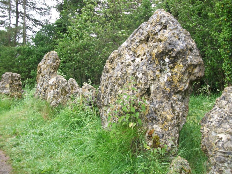
Southern arc of stones
There’s masses to be said on this site, which can’t possibly be added all in one go (I’ve literally got a full unpublished book on the many aspects of this lovely site) — so this entry will be updated occasionally with additional bits and bats of info and images as time floats by.
This remarkable and quite atmospheric megalithic complex has so much to say for itself that entire books have been written on the place (see the extensive references below), dealing with its archaeology, folklore and ritual use. I was very fortunate around the turn of the 21st century, to be able to live in an old hut that used to stand in the copse of trees just outside the circle, where I had numerous weird and wonderful experiences with people, wildlife, and what some might call the more eosteric life of the place…
1920s Ground-planMr Taunt’s 1907 plan
The King’s Men is a near-perfect circle of oolitic limestone uprights. Thought for centuries to be the memorial site of some victory by the Danish King Rollo, they have been described by many historians, travellers and antiquarians from the 14th century upwards. Several early writers described a sort of “avenue” running from the circle, not unlike the one perceived at Stonehenge and elsewhere. Evidence for this cannot be fully disregarded, as there are some recumbent monoliths along the road beside the stone complex, known as the Jurassic Way. This was a prehistoric trade route and it is more likely than not that some other uprights would have been nearby.
The Rollright Stones were used as the prime base for what was known as the Dragon Project: an exploratory examination of potential electromagnetic anomalies that were recorded at the standing stones here by scientists, geomancers and archaeologists who were involved daily monitoring work over many years. Much of this was published in Paul Devereux’s book, Places of Power – required reading for everyone who pretends an interest in megalithic sciences.
Northern section of the ring
The Rollright complex today consists primarily of three sites: the Whispering Knight’s portal dolmen, the King’s Men stone circle, and the King Stone. Of these, it is the stone circle which draws most attention. Several alignments are connected with the complex. The original ritual use of the place would have, primarily, involved rites of passage and death rituals; though it seems obvious that menstrual rites were also an important social event here. After dark, this stone circle has distinctly ‘female’ spirit, sometimes manifesting in a quite wrathful form (please don’t confuse any of the modern witchcraft mythos with such things – they are fundamentally different in both social and ritual aspects). Women obviously played a large part in the ritual use and geomantic layout of the original complex. It also seems likely that the stone circle was used as a moot spot, which may have been in use until medieval times. The recent discovery of the carving of a family crest, at least 500 years old, implies this.
Until Tom Wilson and I lived in the hut at the circle in the 1990s, previous reports of ‘carvings’ at the stone circle were few and debatable. But two of the stones in the Rollright circle have quite distinct carvings on them. The most pronounced is etched on the tallest stone (stone 1 – Barnatt Survey) and comprises of a typical heraldic shield – although we cannot, as yet, ascertain the motif in the middle of the shield. This was first seen by a visiting tourist who wanted to remain anonymous, but the finding was written up in an article I wrote shortly afterwards. (Bennett 1999) The image below – reproduced courtesy of Alistair Carty’s Archaeoptics Limited laser scanning company – clearly shows the carving, which confirmed the initial discovery. The report of his findings can be read here.
Not unsurprisingly, since the discovery of the shield various screwy interpretations have been put forward to account for the design. My favourite has to be the one suggested by a pagan friend of the Rollright Trust, who, occult-like and all secret (y’ get the drift) reckoned it was all to do with King Arthur! Needless to say, my response of, “Y’ talking bollox mate!” was received somewhat nervously by pagan Karin Attwood and the twee little entourage who were discussing the shield, in the usual ‘secrecy – secrecy’ hush-hush tone of false witches and similar idiots!
A few months later I found another set of carvings on stone 62 (Barnatt survey), comprising a set of Ogham letters. These Ogham are very faint and are best observed before midday, when lighting conditions highlight them much clearer. If anyone can decipher them, it would be greatly appreciated. (though please don’t gimme some shit about King Arthur)
Folklore
Folklore ascribes that the number of stones in the complex cannot be counted (a motif found at other megalithic sites) and, intriguingly, of the surveys done here, no two are the same! One early illustration of the circle shows 30 stones, nother describes 46, and one survey describes just 22 stones! As the 20th century progressed the numbers increased dramatically, with surveys differing at 58, 60, 71, 72, 73, 77 and 105. The present-day ‘guesstimate’ is about 77. Weird!
Folklore tells that if you can count the stones three times in a row and get the same number, you may have any wish you choose. But recently this has become reversed and it is said to be a curse if you count three times the same. Intriguingly, modern visitors who allege no superstitious beliefs, will not count the stones a third time if the same number crops up twice.
The best-known folk tale of this place is of the King, his men and the knights, who “were once men who were changed into vast rocks and fossilised,” as Camden first put it in 1586. The King’s men sometimes go to drink at a well near Little Rollright, as does the king, but he only goes at certain times. At midnight however, on certain days, the King’s Men have sometimes been known to come to life, join hands and dance in a circle. This sounds more like a folk remnant of ritual use here.
Faerie folk are said to live beneath the circle, in great caverns, some of which are linked up to the single monolith across the road. Ravenhill [1926] described how local folk had sometimes seen the little people dancing around the circle by moonlight, but nobody has seen them of late.
References:
Anonymous, The Rollright Stones: Theories and Legends, privately printed, n.d.
Anonymous, ‘Oxfordshire Mysteries,’ in The Ley Hunter 86, 1979.
Aubrey, John, Monumenta Britannica, Milbourne Port 1980.
Barnatt, John, Stone Circles of Britain (2 volumes), BAR: Oxford 1989.
Bennett, Paul, ‘Remarkable Carving found at the King’s Men Stone Circle, Rollright, Oxfordshire,’ in Right Times 5, 1999.
Bennett, Paul & Wilson, Tom, The Old Stones of Rollright and District, Cockley Press: London 1999.
Bloxham, Christine, Folklore of Oxfordshire, Tempus 2005.
Bord, Janet & Colin, The Secret Country, Paul Elek: London 1976.
Bord, Janet & Colin, A Guide to Ancient Sites in Britain, Paladin 1979.
Brooker, Charles, ‘Magnetism and the Standing Stones,’ in New Scientist, January 1983.
Burl, Aubrey, A Guide to the Stone Circles of Britain, Ireland and Brittany, New Haven & London 1995.
Burl, Aubrey, Great Stone Circles, Yale University Press: New York & London 1999.
Burl, Aubrey, The Stone Circles of Britain, Ireland and Brittany, Yale University Press 2000.
Clayton, Peter, Archaeological Sites of Britain, Weidenfeld & Nicolson: London 1976.
Cooper, Roy, ‘Some Oxfordshire Leys,’ in The Ley Hunter 86, 1979.
Cowper, B.H., ‘Oxfordshire Legend in Stone,’ Notes & Queries (1st series), 7, January 15, 1853.
Crawford, O.G.S., Long Barrows of the Cotswolds, John Bellows: Oxford 1932.
D., A.J., ‘Rollwright or Rollright,’ in Notes & Queries, 2nd series, 7, 1859.
Devereux, Paul, ‘Is This the Image of the Earth Force?’ in The Ley Hunter 87, 1979.
Devereux, Paul, ‘Operation Merlin,’ in The Ley Hunter 88, 1980.
Devereux, Paul, ‘Operation Merlin 2,’ in The Ley Hunter 89, 1980.
Devereux, Paul, ‘The Third Merlin,’ in The Ley Hunter 92, 1981.
Devereux, Paul, Places of Power, Blandford: London 1990.
Devereux, Paul, The Sacred Place, Cassell: London 2000.
Devereux, Paul, Steele, John & Kubrin, David, Earthmind, Harper & Row: New York 1989.
Devereux, Paul & Thomson, Ian, The Ley Hunter’s Companion, Thames & Hudson: London 1979.
Dyer, James, Discovering Regional Archaeology: The Cotswolds and the Upper Thames, Shire: Tring 1970.
Evans, Arthur J., ‘The Rollright Stones,’ in Trans. Bristol & Glouc. Arch. Soc., 40, 1892.
Evans, Arthur J., ‘The Rollright Stones and their Folklore (3 parts),’ in Folklore Journal, 1895.
Graves, Tom, Dowsing, Techniques and Application, Turnstone: London 1976.
Graves, Tom, Needles of Stone, Granada: London 1980.
Graves, Tom (ed.), Dowsing and Archaeology, Turnstone: Wellingborough 1980.
Gray, William, The Rollright Ritual, Helios: Cheltenham 1975.
Grinsell, Leslie V., The Ancient Burial Mounds of England, Methuen: London 1936.
Grinsell, Leslie V., The Rollright Stones and their Folklore, Toucan Press: Guernsey 1977.
Hamper, W., ‘Observations on certain Ancient Pillars of Memorial, called Hoar Stones,’ in Archaeologia, 25, 1833.
Hawkes, Jacquetta, A Guide to the Prehistoric and Roman Monuments in England and Wales, BCA: London 1973.
Higgins, Geoffrey, The Celtic Druids, Rowland Hunter: London 1829.
Krupp, E.C., In Search of Ancient Astronomies, Chatto & Windus: London 1979.
Lambrick, George, The Rollright Stones: The Archaeology and Folklore of the Stones and their Surroundings, Oxford Archaeology Review 1983. (Reprinted and updated in 1988.)
In September, 1928, the old ley-hunter Alfred Watkins was out on one of his many rambles when he “saw a tall stone almost buried in the bank at this crossroads,” appropriately known as Picts Cross, about a mile south of Sellack — so he called it the ‘Picts Cross Stone.’ He also said, “It was Pricker’s and Prick’s Cross in 18th century maps, and Pig’s Cross in the 1832 Ord. Map. Now ‘pig’ is the present Welsh word for “a peak, a point, a pike.””
And a lovely pointy old stone it looks in his old photo! The monolith is in the hedgerow along the old boundary line.
References:
Watkins, Alfred, The Old Standing Crosses of Herefordshire, Simpkin Marshall: London 1930.
Standing Stone (destroyed): OS Grid Reference – TM 052 809
Folklore
This slab of sandstone apparently used to stand upright in one of the fields of Oxfootstone Farm and on its surface is supposed to be the burnt impression of a cow’s hoof-print. Legend tells that there was a fairy cow which would come into the area when times of hardship occurred. During such periods she would freely give her milk to the people, but when the drought was over she stamped down on the stone upon which she stood, burning the imprint of her hoof onto it and magically vanished back from whence she came. A variation of the tale tells of a normal cow whose milk normally supplied the local villagers. But one night a drunken man (in another tale it is a witch) milked the cow dry through a sieve, until only blood came from her udders. At this point, the cow cried out in pain and kicked the stone so hard that she left the mark of her hoof-print on it.
Another tale tells that an ox got a large thorn stuck in its foot and rampaged through the local village, eventually stamping its hoof onto the stone so hard that it left the imprint of its foot here.
Now this might sound presumptious of me — but this tale has all the hallmarks of it being an old folk-remnant telling the origin of some cup-and-ring marked stone. We find a number of cup-and-rings with creation tales similar to this. Are there any local archaeologists or enthusiasts in Norfolk who might be able to locate any remains of this possible carved stone?
References:
Burgess, Michael W., The Standing Stones of Norfolk and Suffolk, ESNA 1: Lowestoft 1978.
Dutt, W.A., The Ancient Mark-Stones of East Anglia, Flood & Sons: Lowestoft, 1926.
Cursus (destroyed): OS Grid Reference – TF 125 078
Archaeology & History
Much of this site has unfortunately been completely destroyed. Thought by Colin Burgess (2001) to be one of the earliest cursus monuments, it was Paul Devereux (1989) who gave the clearest early description of this site,* telling:
“This site is to be found…between the village of Maxey and the River Welland, south of Market Deeping. When discovered by aerial photography the cursus was already partially destroyed… The northwest segment ‘starts’ almost on the banks of the Welland and goes southeast on a straight course to an obliterated point where a change of alignment occurred, and the cursus continues in a different direction. The total known length is 1930 yards (1.77km), and the width averages 190 feet (58 metres). The ditches themselves display subtly different orientations, but are in straight sections. The investigations of F. Pryor suggests that the northwest length of the cursus was constructed long after the southeast portion, when the latter’s ditches had become silted up (banks do not seem to have been present). The southernmost ditch of the southeastern section bisects two circular sites. Site A is particularly interesting. It occurs just east of the…change in direction, or junction of the two cursuses if such was the case.”
And such is the case, as recent discoveries have found. But before this was known for sure, Devereux wrote, that “a segment of cursus ditch emerges from this vaguely henge-like site, 450 feet in diameter, in the direction of the nearby church” of St. Peter.
The “henge-like site” described here has been defined by Oswald, Dyer and Barber (2001) as one of the enigmatic ’causewayed enclosure’ monuments – out of which emerges the other seperate alignment, the Etton Cursus, heading southeast.
References:
Burgess, Colin, The Age of Stonehenge, Phoenix: London 2001.
Loveday, Colin, Inscribed Across the Landscape, Tempus: Stroud 2006.
Oswald, A., Dyer, C. & Barber, M., The Creation of Monuments, EH: Swindon 2001.
Pennick, N. & Devereux. P., Lines on the Landscape, Hale: London 1989.
Pryor, Francis, Britain BC, Harper-Collins: London 2003.
* The OS-reference for this site is of the northwestern end of the cursus. The southeastern terminal is at TF139063.
Although very little of this cursus can be discerned on the ground, the scar of the monument is clearly visible from the air (as the GoogleEarth image shows, below). In 1989 the great archaeo-geomancer, Paul Devereux, visited the place hoping to see the monument, but said that no remains were visible at ground level, although noted how its western end is marked by the Long Bredy burial mound. Sitting amidst a mass of later neolithic and Bronze Age ceremonial remains, this old cursus aligned SE to NW. Devereux told how,
“the extended axis of the cursus…to the east, goes through a group of round barrows on the crest of a ridge on Black Down about a mile away. If diagrammatic material published by an investigating archaeologist is accurate, the alignment continues to the Nine Stones circle…immediately by the roadside a short distance west of Winterbourne Abbas.”
The monument has been measured at be at least 130 yards (100m) long and 28 yards in diameter at its greatest point.
References:
Pennick, Nigel & Devereux, Paul, Lines on the Landscape, Robert Hale: London 1989.
From Litton Cheney go north up the White Way road until it meets the main A35 crossroad. Go across the road, then get over the fence on your right and onto the rise in the hill. These earthworks, or timber circle remains, are under your feet!
Archaeology & History
Lay-out of site by O.G.S. Crawford, 1939
Shown on modern OS-maps as an ‘earthwork’, but ascribed elsewhere as a timber circle, when Stuart & C.M. Piggott visited and surveyed this site in the 1930s, they thought it to be the remains of stone circle. Found on a prominent rise in the landscape with excellent views all round here, the Piggott’s description of the site told:
“It consists of a shallow ditch with internal bank, enclosing a somewhat oval area measuring 75 feet from north to south, and 63 feet from east to west. The ditch, which lies on the southeast, where the ground has been disturbed, does not reach a depth of more than about one foot, while the bank rises nowhere above 2.5 feet. It is possible there was an entrance on the southeast, but the bank is disturbed at this point. On the crest of the bank on the southwest are 3 almost circular depressions, some 6 feet in diameter, and placed 20 feet distant from one another along the circumference of the bank. Another similar depression is on the northeast, while yet another may have existed in the disturbed portion of the bank on the southeast.”
It was these finds which led them to suppose a ring of stones originally surmounted this small hillock, twelve in all.
Ground-plan by O.G.S. Crawford
Another site — which they called ‘Litton Cheney 2’ — was found less than 50 yards to the east of here by a Mr W.E.V. Young and the Piggotts. These remains comprised of, “a very shallow and regular ditch surrounding a circular area 47 feet in diameter. A single sarsen lies on the inner lip of the ditch on the southeast” which, they thought, may have been the solitary remains of yet another stone circle. Three other sarsen stones were found 90 feet south of here, but they were unsure whether they related to the circle or not.
Archaeological remains from here dated from 2200-1400 BC and local researcher Peter Knight (1996) thought that the sites ascribed here as megalithic rings to be correct. He also found that tumuli visible some 5 or 6 miles southeast of here, on top of Black Down Hill (where the Hardy Monument’s found), “marks out the winter solstice sunrise.” A dip in the horizon to the northwest, he claims, also marks the summer solstice sunset from here. Knight also mentions how “both Litton Cheney sites lie close to a ley line going to the Nine Stone Circle and beyond.”
References:
Knight, Peter, Ancient Stones of Dorset, Power: Ferndown 1996.
Piggott, Stuart & C.M., ‘Stone and Earth Circles in Dorset,’ in Antiquity, June 1939.
In Pennick & Devereux’s (1989) early assessment of our enigmatic cursus monuments, he wrote the following brief notes of this particular site:
“The crop marks of another fragmentary cursus were found in Gloucestershire immediately north of Lechlade, to the west of the River Leach. The crop marks aligned northwest-southeast for 174 yards (160 metres) and were 160 feet (50 metres) wide. Only the square northwest end is known. Excavations were carried out in 1965 in advance of gravel workings. No finds were reported, but two out of three cuttings revealed a post-hole on the inside of the ditch.”
References:
Pennick, Nigel & Devereux, Paul, Lines on the Landscape, Hale: London 1989.
Stone Circle (destroyed): OS Grid Reference – TG 524 035
Archaeology & History
Several local history records describe there being a circle of ten standing stones in a field called ‘Stone-field’ or ‘Stone-piece’ – now covered by a housing estate at Gorleston-on-Sea, south of Yarmouth. In 1875, C. J. Palmer said that,
“there is a tradition that the Druids had a temple at Gorleston, some remains of which existed down to a comparatively recent period. It is supposed to have stood on a field next to the road to Lowestoft, upon what is called Great Stone Close; and it has been asserted that some huge stones remained standing until 1768, when they were destroyed by digging round their base and dragging them down by ropes. There are also two fields called Further Stone Close and Middle Stone Close, so that it is possible the Druidical circle, if it ever existed, may have had a wide extent”.
A painting of the site was reported to have been viewed by members of the Norfolk & Norwich Archaeological Society in 1888, but I’ve been unable to find out where this has gone. Anyone out there got a copy? Or know where it hangs? An image of this lost stone circle would be hugely welcome!
References:
Burgess, Michael W., The Standing Stones of Norfolk and Suffolk, ESNA 1: Lowestoft 1978.
Palmer, C.J., The Perlustration of Great Yarmouth – volume 3, George Nall: Gt Yarmouth 1875.
")


")

")


