Settlement (destroyed): OS Grid Reference – TL 811 136
Archaeology & History
Sadly this site has been built over, as happens so much down south it seems (regional archaeo’s, architects, councillors and businesses are very much in each other pockets – even those who allege ‘pagan’ allegiances to ancient sites – hence the demise of ancient sites). Which is a pity, as it sounded a decent spot! Essex county council employee, Robin Turner, forwarded a summary of the findings from the site to The Prehistoric Society following an assessment prior to its destruction at the end of the 1970s. The brief account of what was there told:
“A small area of the site contained part of an Iron Age settlement, probably of village proportions. Three hut circles, two possible hut circles and two square four-post structures were found, as well as a number of ditched enclosures. The main settlement area was enclosed by a multi-phased series of associated palisades and ditches, the earliest of which had a causeway and external protective fence, which may have served as a defended entrance. One of the four-post structures, c.3m square, lay immediately inside the gap, and may have been a gatehouse or lookout. Three main areas were enclosed outside the settlement and are thought to have represented a stock enclosure, a working area and a field. Some evidence of pottery production, weaving, thatching and metalworking was found. The presence of unusually large quantities of deer and dog remains may have had some religious significance which carried on into the Roman period.”
Turner and his team “hoped to investigate the insdie of the settlement area more thoroughly in 1980,”but I aint been able to get a copy of the report. There was also found remains of a Roman temple here, including artifacts that were thought to have been offerings to the gods or local spirits.
References:
Champion, T.C., (ed.), “Summary Excavation Reports,” in Proceedings of the Prehistoric Society, volume 46, 1980.
Turner, Robin, “Excavations of an Iron Age Settlement and Roman Religious Complex at Ivy Chimneys, Witham, Essex, 1978-83,” East Anglian Archaeology Monograph no. 88, 1999.
Stone Circle (destroyed): OS Grid Reference – SU 0986 6713
Archaeology & History
Smith’s plan of the site
This all-but-destroyed megalithic ring is all-but-unknown in most of the archaeological gazetteers — including even Burl’s (2000) magnum opus! But we know it was there. And according to the Avebury authority Pete Glastonbury , there “are a couple or three small stones buried on the hill but nothing else to see.” Which is a pity, as the site sounds like it was something to behold in bygone times. Although it seems to have been described initially by the legendary druidical antiquarian, William Stukeley, a more lengthy description followed in the 19th century by the reverend A.C. Smith (1885), when he and a friend took it upon themselves to cut back some of the turf that was covering a number of stones — and they weren’t to be disappointed!
The site itself appears to have stood right on the southern boundary line of Avebury parish, meaning that the site could have been named and cited on any early boundary perambulation records that might exist of the parish. (do any of you Wiltshire folk have access to any such old records?) But if there are no such early accounts, the earliest record we’ll have to stick with is good old Mr Stukeley (1743), who only gave it a passing mention, saying:
“Upon the heath south of Silbury was a very large oblong work like a long barrow, made only of stones pitch’d in the ground; no tumulus. Mr Smith before-mentioned told me his cousin took the stones away (then) fourteen years ago, to make mere (boundary, PB) stones withal. I take it to have been an Archdruid’s, tho’ humble, yet magnificent; being 350 feet or 200 cubits long.”
Nearly 150 years later Reverend Smith gave us a more detailed account, and ground-plan, describing the place as,
“a stone circle, of considerable dimensions, though imperfect and formed of very small sarsens, but which I believe to have been in some way connected with Abury. Though it appears to have been mentioned by Stukeley one hundred and fifty years ago, it had been long since buried, and completely forgotten till I was fortunate enough to discover it by digging in the year 1877. I was led to the discovery by the suspicious look of certain stones which, though scattered in no regular form, appeared as if they might have once stood erect, in some sort of order, on the segment of a large circle. I had often stopped to examine them as I wandered over that part of the downs; till at last previous suspicions ripened into conviction, as closer observation revealed sundry other stones just showing above the ground, and there also seemed to be faint indications of a trench, all pointing, with more or less accuracy, to the supposed circle. Not to dwell upon the details of the investigation, which, however, were of singular interest to me, the result was that (with the permission of both owner and occupier of the land, and assisted by Mr William Long), I probed the ground in every direction, and uncovered the turf wherever a stone was found: and on our first day’s work we unearthed no less than twenty-two sarsen stones, all forming part of the circle, and lying from two to twelve inches below the surface. These stones were all of small size, some of them very small, but that they were placed by the hand of man in the positions they now occupy, in many cases nearly touching one another, and that they formed part of a large circle or oblong, admits, I think, of no doubt. I say part of a circle, because, though the northern, southern and eastern segments are tolerably well defined, I could find scarcely a single stone on what should be the western segment to complete the circle. That the area thus enclosed is not insignificant will appear from the diameter (in length, or from north to south, 261 feet; and in breadth, or from east to west, 216 feet). Again, its position (due south of Silbury, and within full view of it, as well as the Sanctuary on Overton Hill, and with Abury immediately behind Silbury, due north of it, from which also Silbury is equidistant) seems to intimate that it may have had some connection with the great temple.”
A ley running through the circle (image courtesy Paul Devereux)
Smith then proceeded to query the nature of the monument, commenting on how Sir John Lubbock and members of the British Archaeological Association were intrigued by the remains, but a little perplexed and unable “to form any opinion” as to the exact nature of the site. But this didn’t stop mythographer and historian Michael Dames (1977) who, in his classic Avebury Cycle, suggested that the site “marked the navel of the landscape goddess” in the region.
The site didn’t go unnoticed in Devereux and Thomson’s (1979) classic Ley Hunter’s Companion, where it plays an important point along a ley that runs north-south for 13 miles between Bincknoll Castle at the north, to Marden Henge at the south. Such an alignment had been noted much earlier by other archaeologists and historians.
The site does look strange for a stone circle in Smith’s ground-plan and has more the hallmarks of a type of enclosure or settlement of some sort. It certainly wouldn’t be out of place, design-wise, as a prehistoric settlement in our more northern climes. However, without further data it seems we may never know the true nature of this old stone site…
References:
Dames, Michael, The Avebury Cycle, Thames & Hudson: London 1977.
Devereux, Paul & Thomson, Ian, The Ley Hunter’s Companion, Thames & Hudson: London 1979.
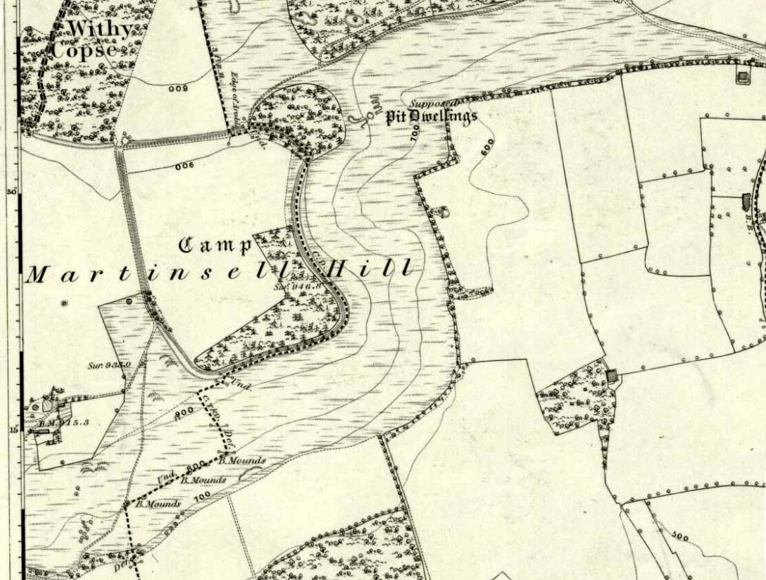
The second highest of Wiltshire’s prehistoric camps or hillforts, Martinsell Hill was described as early as the 13th century as ‘Mattelsore’ and was known in local dialect and literary forms as variants around the word mattels, until the 16th century, when the title became altered in literature and for the first time became known as ‘Martinshall’ (and variants thereof), which has stuck ever since. As the etymologists Gover, Mawer & Stenton (1939) proclaimed,
“the first element (mattels, PB) must be associated with the old english name for the camp which stands on top of it: the Mætelmesburg of the Pewsey charter” —
A.C. Smith’s old map
Which the authors think derived from “Mætelmesora, i.e., ‘Mæþelhelm’s bank'”, being the name of a tribal leader or elder who gave his name to the hill upon which the fort was built. Margaret Gelling echoes the sentiment in her Place-Names in the Landscape, but we must keep in mind that such derivation is still a quite speculative etymology and one which doesn’t seem to be able to be proven (as yet!).
The hillfort and its remains were described in some detail in the second volume of Colt Hoare’s classic Ancient Wiltshire (1819: 107), where he wrote:
“Martin’s Hill or Martinshal Hill is in North Wilts what Long Knoll near Maiden Bradley is in South Wilts, ‘collis longe spectabilis’. This elevated point commands a most advantageous prospect of the rich vale that separates the northern and southern districts of our county, , and is rendered interesting to the antiquary by an extensive earthenwork that crowns the summit of the hill. Its form resembles an oblong square on all sides, except towards the east, where it bends inward in order to humour the natural shape of the hill. Its area, which is in tillage, comprehends thirty-one acres; and as several entrances have been made through the ramparts for the convenience of agriculture, it is difficult to ascertain on which side were the original approaches to the camp. This hill, in its formation, presents a peculiarity rather contrary to the usual system of nature, by rising in height towards the east, where a bold and tremendous precipice of smooth turf shelves down from the summit to the base of the hill. This eminence is more remarkable for the rich and extensive prospect which it affords than for the plan of its entrenchments, which consists of a single vallum and fosse. Not having discovered by digging any certain marks of ancient populations within its area, I am inclined to think that it may be considered as an asylum to which the Britons, who were very numerous in its environs, sent their families and herds in times of danger: the single vallum and ditch prove its British origin, and the great extent of its area seems to warrant this conjecture.”
Hippisley Cox’s ground-plan
This aint a bad assumption for a fella who wrote this 200 years ago without the aid of excavation or modern archaeocentric analysis. But we can see that Hoare was utilizing that dying virtue of common sense here, and find that much of what he said remains the echoed narrative of modern archaeologists who, I believe, still aint done a detailed excavation on the site themselves. (weird for down South!) Later in the 19th century, when the reverend A.C. Smith (1885) visited and wrote about the hillfort, he added little to Hoare’s earlier words. And the descriptive narrative of the site remained roughly the same (Massingham’s intriguing ascriptions aside!) even after a small excavation was undertaken in 1907, which found very little. Hippisley Cox (1927) passed this way in his fine travelogue of ancient roads and trackways in Wessex, describing the enclosed top of this hill as
“the site of a complete neolithic settlement, including dew-ponds, a cattle compound, a flint quarry, lynchetts, dicthes of defence and deep cattle tracks formed by much going and coming of beasts from the valley.”
He may have been right! In more recent times Geoffrey Williams (1993) describes the Martinsell hillfort, which again only gives slightly more info than Colt Hoare’s 1819 narrative. The site covers 32 acres in size, is roughly rectangular in form, measuring roughly 330 yards (302m) across east to west, and 480 yards (439m) north to south. There appears to be at least one entrance on its northeastern edge.
Folklore
What seems to be a survival of prechristian sun lore is found in one or two of the events that used to happen upon and around Martinsell. A number of local history books give varying descriptions of the events here, but Devereux and Thomson (1979) condense the information nicely, telling us that
“The camp seems to have been a focus for curious Palm Sunday ‘games’ in past centuries, one of which involved a line of boys standing at intervals from the base to the summit of the hill. Using hockey sticks, they then proceeded to knock a ball in succession up the hill to the top. Another activity was the throwing of oranges down the hill slopes with boys going headlong after them. Evene more strangely, local youths used to slither down the escarpment on horses skulls.”
Mythographer and writer Michael Dames (1977) thought that such festive activities on and around the hill related to remnants of ancient goddess worship here.
Ley line running from Martinsell (image courtesy Paul Devereux)
In Paul Devereux & Ian Thomson’s (1979) ley hunter’s guide, the Martinsell Hill site stands at the beginning of a ley, which then runs northwest for more than seven miles, eventually ending at the well known causewayed enclosure of Windmill Hill — but not before passing by the Avebury stone circle and several prehistoric tombs on route. This ley is a simple alignment between sites (as the ‘discover’ of leys, Alfred Watkins described them) and has nothing to do with the modern contrivance of energy lines.
…to be continued…
References:
Bradley, A.G., Round about Wiltshire, Methuen: London 1948.
Dames, Michael, The Avebury Cycle, Thames & Hudson: London 1977.
Devereux, Paul & Thomson, Ian, The Ley Hunter’s Companion, Thames & Hudson: London 1979.
Gomme, Alice B., “Folklore Scraps from Several Localities,” in Folklore Journal, 20:1, 1909.
Gover, J.E.B., Mawer, A. & Stenton, F.M., The Place-Names of Wiltshire, Cambridge University Press 1939.
Harding, D.W., The Iron Age in Lowland Britain, RKP: London 1974.
Hoare, Richard Colt, The Ancient History of North Wiltshire, Lackington, Hughes, Mavor & Jones: London 1819.
Massingham, H.J., Downland Man, Jonathan Cape: London 1926.
Partidge, T.B., “Wiltshire Folklore,” in Folklore Journal, 26:2, 1915.
Smith, A.C., A Guide to the British and Roman Antiquities of the North Wiltshire Downs, Wiltshire Archaeological & Natural History Society 1885.
Williams, Geoffrey, The Iron Age Hillforts of England, Horace Books 1993.
Another one of those rare cup-marked stones from Cornwall, once again found in association with a burial— but once again destroyed, this time by having an airfield built over the tomb! This “cup-marked and perforated slab” was said by Paul Ashbee (1958: 192) to have been unearthed “by Mr C.K. Andrew” in 1941 when he was digging in the Nancekuke round barrow. Yet an earlier reference to the same site by Mr o’ Neil (1948: 26) told that “the grave was rifled c.1926, but in the ditch there were found traces of a Bronze Age wooden shovel and a perforated and cup-marked slate.” For any students studying this arena, the correct date would appear to be the earlier of the two.
I’ve not been able to locate any decent photos or diagrams of this small cup-marked stone and would truly appreciate an illustration of it if anyone could get hold of one.
References:
Ashbee, Paul, “The Excavation of Tregulland Burrow, Treneglos Parish, Cornwall,” in Antiquaries Journal, volume 38, 1958.
o’ Neil, B.H. St. John, “War and Archaeology in Britain”, in Antiquaries Journal, volume XXVIII, January-April 1948.
Running roughly north-to-south, this cursus was 2¼ miles long (3600 metres) and comprised of two linear sections from a field in Stanwell up through the western side of Heathrow Airport averaging, curiously, just 24 yards (22m) across. Of course nothing of it can be seen today as the airport and surrounding industrial crap has destroyed it. The cursus had a lengthy internal bank along its length. During excavation work done at the Perry Oaks Sludge Works section in Hillingdon, archaeologists found evidence for a short avenue of posts, about 110 feet long, apparently constructed prior to the cutting of the cursus’ ditches, following the same direction/alignment of the subsequent monument. In Roy Loveday’s (2006) survey of cursus monuments he said this of Heathrow’s cursus:
“This site, striking across land so flat that it has been selected for Heathrow Airport, extends for some 4km, crosses two rivers and stops by a stream — originally perhaps a more major river. So straight and apparently narrow is it (20m) that it was originally taken to be a Roman road. Early excavation seemed to support the idea: vestigal remains areas of gravel between the ditches were scored by shallow gullies resembling cart ruts. Later excavation, however, demonstrated that the ditches of a Late Bronze Age field system cut across it and several scarps of Peterborough Ware (i.e., pottery – PB) were recovered from its ditches. Evidence also emerged of a short (50m) ragged, double row of posts, removed before the ditches were dug on the same alignment. That this was a bank barrow was hinted at by the Charlecote test and by reduction in the depth of field ditches as they crossed the central area.”
Confirmation that an earthen bank of some kind running near the middle of the cursus was confirmed by analysis of early Ministry of Defence aerial photographs. For those who would like a more detailed description on this site, I refer you to the excellent paper by o’ Connell. (1990)
…to be continued…
References:
Barclay, Alistair, et al, Lines in the Landscape, Oxford Archaeological Unit 2003.
Loveday, Roy, Inscribed Across the Landscape, Tempus: Stroud 2006.
o’ Connell, M., “The Heathrow-Stanwell Cursus,” in Current Archaeology, 9, 1986.
o’ Connell, M., “Excavations during 1979-1985 of a Multi-Period Site at Stanwell,” in Surrey Archaeological Collections, 80, 1990.
This once-impressive Bronze Age tomb is now much denuded and stands besides the legendary Fleam Dyke. The name of Mutlow was first used to describe this site in the 1812 Enclosure Act and means, literally, an “Assembly Hill” or Assembly burial mound. Reaney (1943) told that it was situated “at the junction of the boundaries of Great Wilbraham (Staine Hundred), West Wratting and Balsham (Radfield Hundred) and Fulbourn (Flendish Hundred)”, and was obviously an important moot spot where local tribal and council laws were made.
The great Cambridge archaeologist, Tom Lethbridge (1957) briefly described the place in his fascinating survey of the nearby hill-figures, Gog and Magog, saying:
“The hill itself is a Bronze Age barrow which was dug by the Hon. R.C. Neville about a hundred years ago. In it were, amongst other things, glass beads brought to Britain from the eastern Mediterranean in the fifteenth century before the birth of Christ. The barrow, which was presumably the site of a moot in Saxon times, seem to have been used as a sighting point for the construction of the Fleam Dyke… A circular Roman building, either a temple, or possible a signal station, stood close to Mutlow Hill.”
Lethbridge pointed out that another lesser-known trackway — “known in Saxon times as ‘the Street'” — also passed here, saying:
“When the land is ploughed and the light is right, you can see the numerous dark lines on the soil, all converging on Mutlow Hill. These are the old hollow ways of the Icknield Way and the Street.”
Folklore
One legend here speaks of a golden chariot that is reputedly buried either inside, or near to the old tumulus. Lethbridge (1957) again told of hearing this tale, though narrated, “it was said to be buried in Fleam Dyke near Mutlow Hill.” When he asked a local lady about the tale,
“She replied that she had always heard that it was not in the dyke itself, but in the road which passed the dyke and went on to West Wratting and the southeast.”
References:
Lethbridge, T.C., GogMagog: The Buried Gods, RKP: London 1957.
Reaney, P.N., The Place-Names of Cambridgeshire and Isle of Ely, Cambridge University Press 1943.
Stone Circle (destroyed): OS Grid Reference – SU 161 684
Also Known as:
Clatford Stone Circle
Archaeology & History
John Aubrey’s early drawing (soz about the crap quality)
Also known as the Clatford Circle, it was described by both of the old pioneers, John Aubrey and William Stukeley: Aubrey saying the monument could be found “in a lane leading from Kennet to Marlborough… (consisting) of eight huge large stones, roughly hewn… in a circle, which never could be by chance.” Will Stukeley reckoned that four other stones close by, “may possibly have been the beginning of an avenue.” We might never know for sure.
The local Avebury authority, Pete Glastonbury, showed us a spot which he thinks may have been the where the circle stood, and where a couple of decent-looking stones lay by the side of the track that could have once been a part of this circle. It looked as good a contender as anything else. Has all trace of this monument truly been destroyed?
References:
Burl, Aubrey, Prehistoric Avebury, Yale University Press 2002.
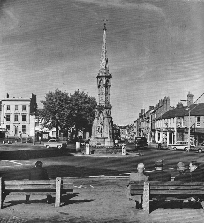
The original stone monolith that stood here has long since been destroyed (by christians arguing amongst themselves) and the ornate edifice that we see today was erected in 1859 to commemorate the marriage of Queen Victoria’s eldest daughter, Victoria Adelaide Mary Louisa, to Friedrich Wilhelm of Prussia. Standing more than 52 feet tall, it is of a neo-Gothic design and is one of the tallest crosses in the country. Originally there were going to be six carved statues cut into the niches of the cross, but this was later reduced to three.
First mentioned in place-name records from 1478, the original stone cross was itself very prominent, rising some 20 feet tall and sitting upon a square base of eight steps. It was described by John Leland in his Itinerary when he visited the town sometime between 1535 and 1545, who said:
“At the west part of the street…is a large area, having a goodly cross with many degrees (steps) about it. In this area is kept every Thursday a very celebrated market.”
The old cross was also a site where public notices and proclamations were dispensed to local people and seems to have been an old meeting place. Whether it had a prehistoric predecessor isn’t known.
Folklore
The nursery rhyme we’ve all recited when we were kids and growing-up, has much of its origins around this ornate edifice and in the 20th century was thought to have its origins in pre-christian practices hereby, but this is questionable. The rhyme, to those who don’t know it, goes:
Ride a cock-horse to Banbury Cross,
To see a fine lady upon a white horse,
With rings on her fingers and bells on her toes,
She shall have music wherever she goes.
As Kirsten Ayles (1973) told:
“This rhyme was first recorded in 1784, but it probably originated much earlier. The Banbury Cross mentioned was destroyed at the turn of the 16th century by the Puritan inhabitants of Banbury. It has been suggested that “bells on her toes” points to the fifteenth century, when a bell was worn on the long tapering shoe of each shoe. It has (also) been thought that the “fine lady” was Queen Elizabeth I, or Lady Godiva.”
Another option identifying the “fine lady” in the rhyme is perhaps a member of the Fiennes family, ancestors of Lord Saye and Sele who owns nearby Broughton Castle.
References:
Ayles, Kirsten, “A Short History of Nursery Rhymes,” in This England, 6:3, Autumn 1973.
Gelling, Margaret, The Place-Names of Oxfordshire (2 volumes), Cambridge University Press 1954.
Vallance, Aymer, Old Crosses and Lychgates, Batsford: London 1920.
Acknowledgements:
To Ronald Goodearl, for use of his 1973 photograph of the Banbury Cross.
Cursus Monument (destroyed): OS Grid Reference – TL 735 084
Also Known as:
Springfield Barnes Cursus
Archaeology & History
The first cursus monument discovered in Essex, archaeologists were fortunate when they came to excavate the site in 1979 as they found it almost complete. A rarity these days! Close to the Springfield Lyons causewayed enclosure monument, the cursus here was some 45 yards across and 750 yards long. Like a number of other cursuses, the Springfield one was dead straight all the way down, running northeast to southwest with squared terminii at both ends. (of the Bi category, as Loveday called them) And it appears to have had quite a long period of use.
Springfield Cursus (painting by Frank Gardiner)
The ditch that constitutes the very outline of the cursus — averaging between 3-4 feet in depth all round — was cut into the earth in the neolithic period. It had small ‘entrances’ at certain points along its longer axis, both on the east and west sides. The flat ends of the cursus were both ‘closed’, without entrances or breaks of any kind. Some depositional remains were found scattered at different spots along the course of the ditch: neolithic pottery and flints in both the northern and eastern ditches, but archaeologists were unsure whether these deposits were left at the time the monument was in use, or at a later period — though it seemed consensus opinion that the deposits were from a period when the cursus was in use. Charcoal remains were also found, but these were associated with an internal timber circle that was erected within the northeastern end of the cursus. The timber circle was found to have consisted of 14 upright wooden posts arranged in a near-complete ring, some 26 metres in diameter. It seems highly likely that this part of the monument had some ritual or ceremonial function relating to the dead (“mortuary practices” is the term used at the moment!).
Later excavation work here in 1984 found there to be various other linear and pit-like features within the confines of the monument, and what seemed to be the remains of a barrow beyond its eastern end.
Archaeologist David McOmish (2003), thought that “alignment is also significant,” saying that the “Springfield Cursus, 700 metres long, is aligned on a smaller enclosure some 300 metres away.” The alignment potential here was first suggested by Pennick & Devereux (1989), albeit pointing “to the village of Wexford just over two miles to the southwest.” McOmish also suggested there may have been some an astronomical reason for the alignment of the monument NE-SW, but I’m not aware whether this has been explored further.
The creation of these huge monuments had obvious relationships with human death rites, the spirits of trees, and celestial gods. But much more research is needed at these sites if we’re to find out more about the nature of these prehistoric giants in the landscape.
References:
Buckley, D.G., Hedges, John & Brown, N., “Excavations at a Neolithic Cursus, Springfield, Essex, 1979-85,” in Proceedings of the Prehistoric Society, volume 67, 2001.
Hedges, John D. & Buckley, D.G., Springfield Cursus and the Cursus Problem, Essex County Council 1981.
Loveday, Roy, Inscribed Across the Landscape: The Cursus Enigma, Tempus: Stroud 2006.
McOmish, David, ‘Cursus: Solving a 6000-year-old Puzzle’, in British Archaeology, 69, March 2003.
Pennick, Nigel & Devereux, Paul, Lines on the Landscape, Hale: London 1989.
Pretty simple this one. From Chipping Norton, head west on the A44 for a coupla miles till you hit the lovely Salford village. The church stands out, so head for it and, as you walk towards the building, watch for the small stone cross in front of you.
Archaeology & History
Salford Cross cup-markings
This is curious. Very curious! We might expect to find cup-markings occasionally on some of the cross-bases or other early christian monuments in northern England and Scotland, but to find them in the heart of a small Oxfordshire village where the tradition of cup-marked stones is unknown, was something of a surprise when Tom Wilson and I (1999) found it, to say the least! But this is what we’re looking at here.
Salford Cross remains
On the remains of an old medieval cross, whose broken shaft has seen better days, as the photo shows — and as a personal viewing shows even clearer — there are 3 simple cup-markings etched on one side of the cross-base in Salford churchyard. The cups certainly aint natural, but then also they don’t have the archaic looks of the prehistoric carvings from Yorkshire to Scotland. It would be good if we had a more extensive history of the cross monument itself, perhaps saying precisely where the stones which make it up came from, but local records tell us nothing it seems. If we could ascertain that parts of it were made up of some remains taken from some local prehistoric ‘pagan’ tomb (and a number of tombs have been found in and around this area), then some sense could be thrown upon its position here. But until we can ascertain more about the history of the cross, the three clear cup-markings on the cross-base remain somewhat of a mystery.
Folklore
Lovers of ley lore will be intrigued to find this carved cross-base is on a very accurate ley linking the King Stone, Rollright stone circle, Little Rollright church (where a standing stone can be found in the walling just before it), the Salford Cross and the site of another cross on the hill outside the village.
References:
Bennett, Paul & Wilson, Tom, The Old Stones of Rollright and District, Cockley: London 1999.