Healing Well (destroyed): OS Grid Reference — TQ 3006 7734
Archaeology & History
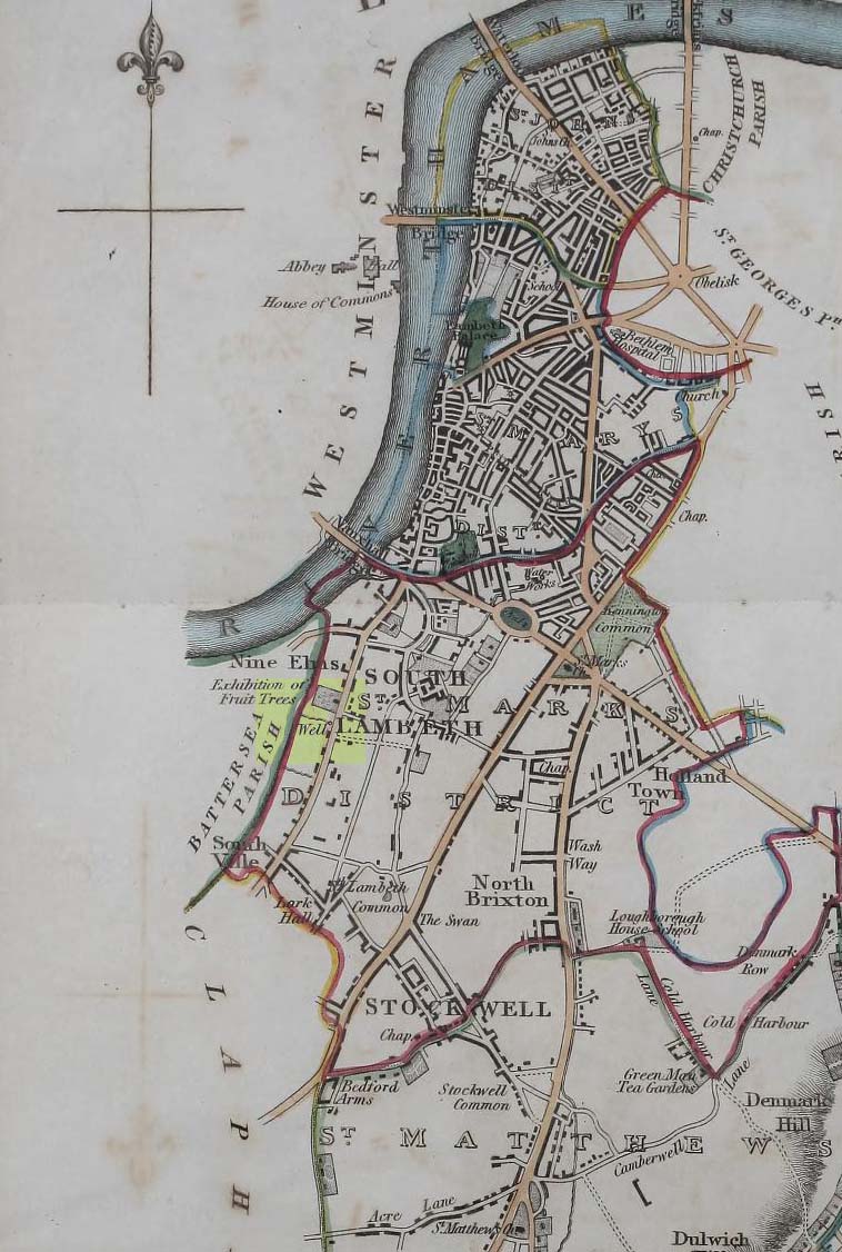
Site on 1824 map
In Thomas Allen’s (1827) huge survey of Lambeth parish, he told that there was little of any interest along Wandsworth Road, apart from a good orchard, “and a fine spring called Vauxhall Well.” According to Daniel Lysons (1792), it was located “not far from the turnpike”; and according to Mr Sunderland’s (1915), was to be found “on the right-hand side of the Wandsworth Road” as you walked down it to the south. Thankfully its position was highlighted on the 1824 map of the parish (right) that accompanied Mr Allen’s work.
It appears to have been built over in the latter-half of the 19th century, soon after William Thornbury (1878) wrote that he thought the well was still visible, but vanished soon after.
The waters were universally ascribed by all historians, from Mr Allen onwards, as being,
“esteemed highly serviceable in many disorders of the eyes, and in the hardest winter it is never known to freeze.”
The name ‘Vauxhall’ derives from that brilliantly famous family name of ‘Fawkes’ (as in Guy Fawkes), being the ‘hall of Fawkes’. The name was first recorded here as early as 1241. (Gover et al, 1934)
Faint flat outline of SE end + ancient circular enclosure
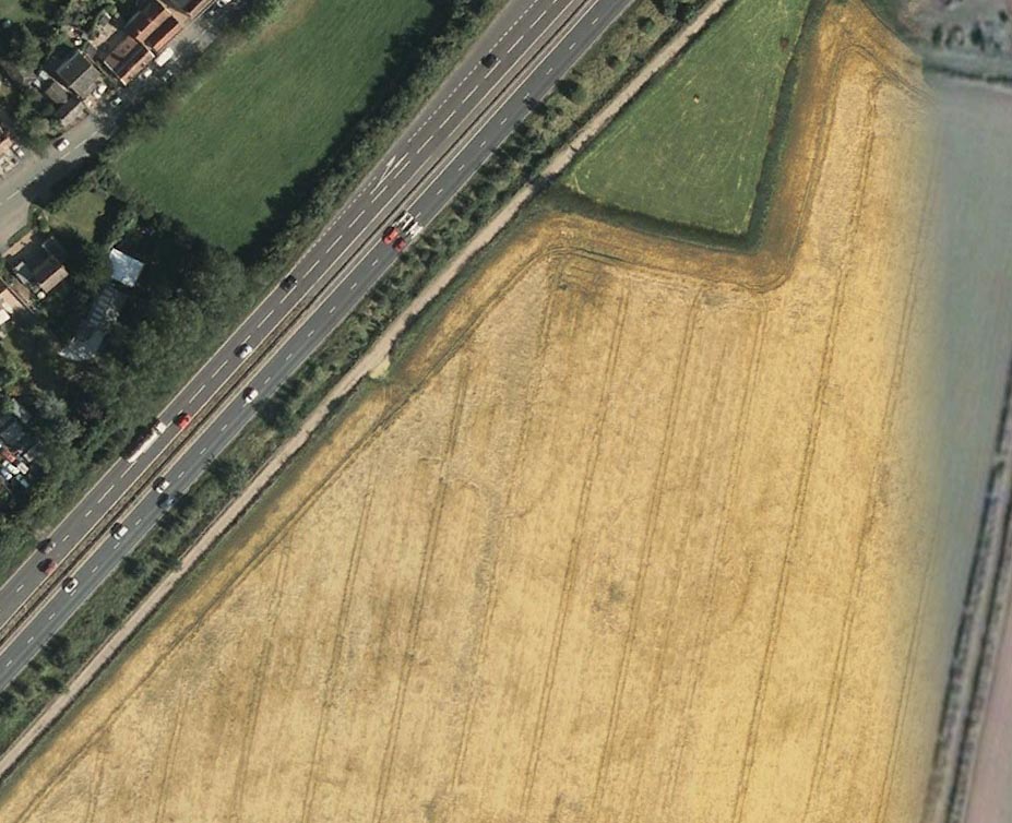
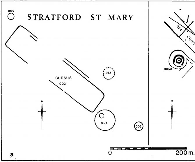
This short and dead straight cursus monument was first described in John Hedges’ (1981) survey, and later mentioned in Harding & Lee’s (1987) corpus on British henges as being in conjunction with a series of circular prehistoric monuments (three circular enclosures existed beyond its southeast and one to its northeast edges, one of which is visible in the aerial image, right).
Cursus ground-plan (courtesy Suffolk Institute Archaeology)
Most of the monument has been completely destroyed by roads and housing, but when complete was said to be 317 yards (290m) long, running from the southeast to the northwest. The flattened southeastern edge measures nearly 63 yards (57.3m) across, and its northernmost width was close to 65 yards (60m) wide.
In Patrick Taylor’s (2015) assessment of this (and other monuments) he thought that the cursus may have served an astronomical function. He may be right. It’s alignment, he told,
“has a very clear orientation 38.5º north of grid west. This represents an amplitude from true west of 40.9º. Allowing for a latitude of 51.97º and altitude of 0.95º, adjusted downwards for refraction to 0.50º, we get from (Alexander) Thom’s table a declination for a body setting to the northwest of 24.15.º This is only 0.23º, just less than half the width of the sun’s disc, more than the sun’s maximum declination in Neolithic times of 23.92º. The alignment thus points rather accurately towards the upper limb or last setting point of the sun.”
Faint remnants of a second cursus monument have been discovered 400 yards to the east.
References:
Harding, A.F. & Lee, G.E.,, Henge Monuments and Related Sites of Great Britain, BAR 175: Oxford 1987.
Hedges, John D. & Buckley, David, Springfield Cursus and the Cursus Problem, ECC 1981.
Last, Jonathan, “Out of Line: Cursuses and Monument Typology in Eastern England,” in Barclay & Harding’s Pathways & Ceremonies, Oxbow: Oxford 1999.
Martin, Edward A., “When is a Henge not a Henge?” in Proceedings of the Suffolk Institute for Archaeology & History, volume 35, 1981.
Acknowledgements: Many thanks to the Suffolk Institute of Archaeology and History, for use of their ground-plan diagram from Edward Armstrong’s article, ‘When is a Henge Not a Henge?’
Tumulus (destroyed): OS Grid Reference – SP 8601 7510
Archaeology & History
According to a Mr Abner Brown (1846), this was one of two prehistoric cemeteries that once existed in Pytchley village, but very little seems to have been written about it. Found on the north side of the village in the field where an old limekiln once stood, this “apparently pagan” site was “about 350 yards northwards of the church.” From his brief description it seems that a large barrow here was accompanied by other smaller ones of the same period. They have all been destroyed.
Royal Commission Ancient & Historical Monuments, An Inventory of the Historic Monuments in the County of Northamptonshire – volume 2, HMSO: London 1979.
Enclosure (destroyed): OS Grid Reference – ST 6706 6307
Also Known as:
Windsbury Hill
Archaeology & History
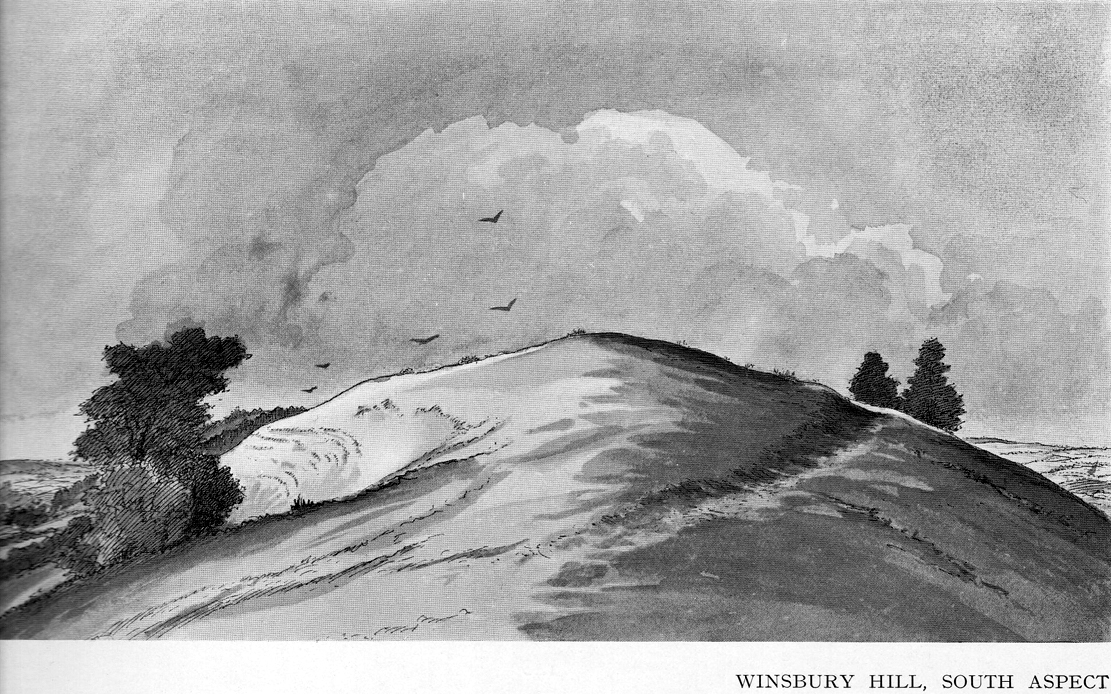
Winsbury Hill earthworks
Apparently, all traces of the possible prehistoric camp or enclosure that were located by Edward Burrow in the 1920s, seems to have vanished. Very little remained of it even then. Lower down the slopes are a distinct series of ancient lynchets (or cultivation terraces), which may date back to the Iron Age—these are clearly visible on the eastern and western sides. Mr Burrow’s (1924) account of the site was as follows:
“Just south of Stantonbury Camp, near Bath, on the adjoining height known as Winsbury Hill, I have traced the almost obliterated remains of a ditch running round the shoulder of the hill, which I have indicated on my drawing. (above)
“On the south and eastern slopes of this prominent hill there are various terraces and scarps, which would repay further investigation. Possibly Winsbury was fortified as an outlier of the more pronounced Stantonbury Camp, standing directly on the line of the Wansdyke, which runs across the valley towards English Combe.”
References:
Burrow, Edward J., Ancient Earthworks and Camps of Somerset, E.J. burrow: Cheltenham 1924.
The exact location of this site remains a mystery. Addison (1951) mentions it as being “close to the Blake Hall Road” where a drinking fountain was erected, but notes that this was not the original site of the spring. It was obviously a medicinal spring of some renown to the local people, before it was appropriated by the wealthy to turn it into a ‘spa well’. In doing so, it brought the attention of those curious lords and ladies, along with King James himself, adorning themselves in usual view as important people, and playing the part in social gatherings, as folks did at those spa wells. But the fad didn’t last long and the spa never really caught on. One account tells how it was a dangerous place for the rich and wealthy to visit! Locals can and do get pissed-off if you steal their basic water supplies!
The primary description of the site is that afforded by Christy & Thresh (1910) in their excellent survey of Essex waters. With no mention of the unimportant local people (!), they told how it was “first discovered” in the early 17th century:
“John Chamberlain, the news-letter writer, writing from London to Sir Dudley Carleton, on 23 August 1619, says:
“‘…We have great noise here of a new Spaa, or spring of that nature, found lately about Wansted; and much running there is to yt dayly, both by Lords and Ladies and other great companie, so that they have almost drawne yt drie alredy; and, yf yt should hold on, yt wold put downe the waters at Tunbridge; wch, for these three or foure yeares, have ben much frequented, specially this summer, by many great persons; insomuch that they wch have seene both say that yt [i.e., Tunbridge] is not inferior to the Spaa [in Belgium] for goode companie, numbers of people, and other appurtenances.”
“We have been quite unable to ascertain anything as to the part of Wanstead parish in which this spring was situated. In all probability, it was quite a small spring. One may infer as much from Chamberlain’s statement that, within a short time of its discovery, the company resorting to it had “almost drawn it dry.” If such was the case, the spring was, no doubt, soon deserted and ultimately forgotten.
“Mr. Walter Crouch, F.Z.S., of Wanstead, whose knowledge of the history of the parish is unequalled, writes us : —
“I have always had the idea that this Mineral Spring was not at the Park end of our parish, which abuts on Bush wood and Wanstead Flats, but in the vicinity of Snaresbrook and on the road which leads to Walthamstow; but it is possible that it was in the grounds of ‘ The Grove ‘ (now cut up and built over). The spring is not marked on Kip’s View (1710), nor on Rocque’s large Map (1735), nor on Rocque’s still larger map of a few years later.”
“Under the guidance of Mr. W. Ping, F.C.S., of Wanstead, Mr. Christy has visited two springs at Snaresbrook — namely, that known as the ‘Birch Well’, in the Forest, near the Eagle Pond, and a spring in the grounds of ‘The Hermitage’; but neither of these is credited locally with being a mineral spring and neither has any appearance of being such. Since then, Mr. Ping has written us as follows: “I have spoken with the oldest inhabitant of Wanstead, a Mr. Merryman, whose knowledge, both local and national, is remarkable and accurate. He tells me that the only Mineral Spring he ever heard of in Wanstead was in the grass bordering the roadside nearly opposite the house, in the Blake Hall Road, formerly occupied by Lord Mayor Figgis, and now by Sir John Bethell, M.P. This spring he remembers well. Its water was chalybeate and left considerable reddish deposit. People came and drank it to give them an appetite. They used to kneel down and drink it from their hands, and also took it away in bottles. Others used to bathe their ankles in it to make them strong. Mr. Merryman adds that, about 1870, drainage operations deprived the spring of its water. The fountain, which has since been put up near its site, supplies waterworks water only.” Mr. Ping adds that, recently when deeper drainage operations were in progress at the spot, water of a very markedly ferruginous character was encountered. This is no evidence that this spring was identical with that which came into prominence in 1619, but very likely it was.
“Mr. Dalton expresses the opinion that, if either surmise as to the position is correct, seeing that the comparison with the Tunbridge Wells chalybeate water was sound, the well in question probably yielded a ferruginous water from the Glacial (?) gravels of the Snaresbrook plateau at their contact with the pyritous London Clay.”
References:
Addison, William, English Spas, Batsford: London 1951.
Christy, Miller & Thresh, May, A History of the Mineral Waters and Medicinal Springs of the County of Essex, Essex Field Club: Stratford & London 1910.
Hembry, Phyllis, The English Spa 1560-1815, Athlone Press: London 1990.
Holy Well (destroyed?): OS Grid Reference – TF 6753 0817
Archaeology & History
Once found in the small woodland known as the High Plantation, this holy well has, seemingly, long since fallen back to Earth. Mary Manning (1994) included it in her survey where she told that in earlier days it could be seen
“in a field which has drainage ditches and cultivation. Here was formerly marshy land draining to the Nar and lying on the south slope of the Nar valley.”
She thought that the title ‘Silver Well’ meant it was a holy site, but others told that it was due to a silver scum that formed on the surface of the waters—and it was a chalybeate (or iron-bearing spring) this is possible.
It was described in Francis White’s (1854) Directory of Norfolk for Shouldham:
“On Mr. Cotton’s estate is a fine chalybeate spring, called Silver Well, which gives rise to a small rivulet which passes through the village. Near this a new spring was discovered about 20 years ago, and both of them possess similar properties to those of Tunbridge Wells.”
This secondary “spring” was another chalybeate well, above which a stone obelisk was erected in 1839.
Folklore
In relation to the object found in the well, Manning (1994) thinks “the objects found could have been pagan votive offerings in a venerated well.” She also told that:
“The well is the subject of a local legend, which takes two forms. One version is that at the Dissolution, treasure from one of the abbeys was hidden in the well. The second says that workmen repairing the well brought up a container/box of silver ware, which was inadvertently dropped back and never recovered. Both tales attribute the silver colour of the well water to the effect of passing over silver treasure.”
A variation on this was noted by folklorist W.B. Gerish (1892) who told that the silver which the workmen dropped back into the well, did so as a result of the devil fighting them over it, and they fled!
References:
Anonymous, Kelly’s Directory of the Counties of Cambridgeshire, Norfolk and Suffolk, Kelly’s Directories Ltd 1925.
Gerish, W.B., Norfolk Folklore Notes, 1892.
Hope, Robert Charles, Legendary Lore of the Holy Wells of England, Elliott Stock: London 1893.
Manning, M., Taking the Waters in Norfolk, NIAS: Norfolk 1994.
White, Francis, Gazetteer and Directory of Norfolk, 1854.
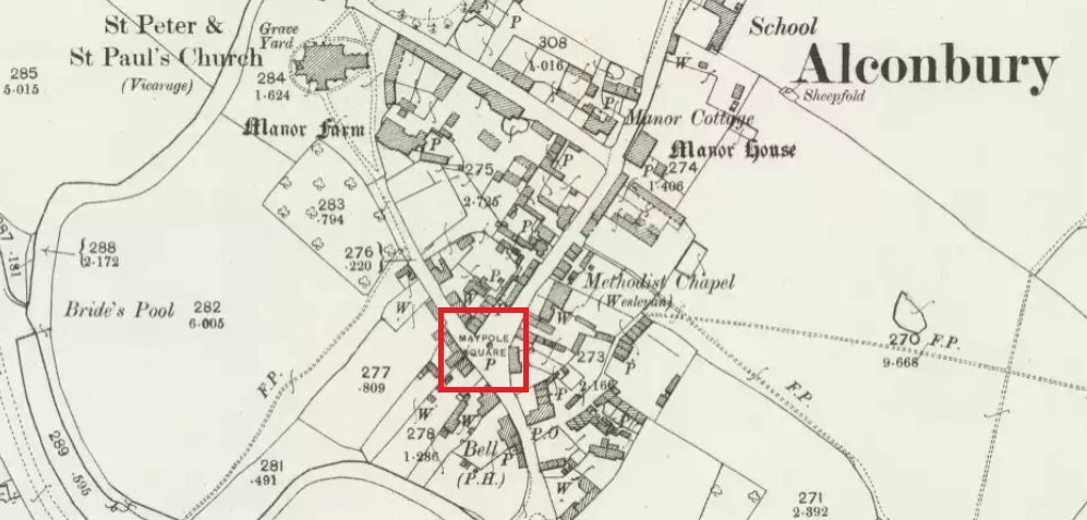
Maypole Square, outlined in red on the 1901 OS map
Maypole Square forms the junction of High Street, Church Way and Chapel Street in the centre of the village.
Archaeology & History
The Alconbury Maypole had passed out of living memory by 1942, but was historically attested by the ‘Maypole Square’ in the centre of the village.
Folklore
C.F. Tebbutt wrote in 1950:
“At Alconbury, it is remembered that about 1890 an old soldier, who lived in the corner house (east end) of the row of cottages facing Maypole Square, used to dig holes in the road opposite the row and set up May bushes there on May day”.
References:
C.F.Tebbutt, “Huntingdonshire Folk and their Folklore”, in Transactions of the Cambridgeshire and Huntingdonshire Archaeological Society, Volume VI, part V, 1942.
C.F.Tebbutt, “Huntingdonshire Folk and their Folklore II”, in Transactions of the Cambridgeshire and Huntingdonshire Archaeological Society, Volume VII, part III, 1950.
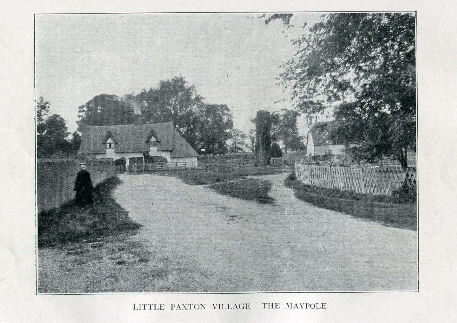
Imposing trunk of The Maypole Tree, right background
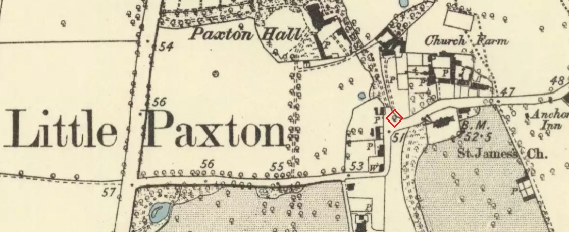
The road layout of the village has changed since the destruction of the Tree, but its approximate position was on the north side of the present High Street, at the junction with the east side of St James’ Road.
Archaeology & History
The Little Paxton Maypole Tree was a very late survival of a tradition where Mayday revellers danced around an actual tree rather than a symbolic tree in the form of a maypole. It was described as “a tall straight elm tree” that stood in front of what was then the village Post Office, and from what may be the only surviving photograph, it appears that only the very substantial trunk survived of what was clearly a very old tree.
1887 6″ OS Map, showing the Maypole Tree outlined in red
A Miss Ethel Ladds, who had been born in Little Paxton, recalled in the early 1940s:
“I remember the old tree very well, it was always called ‘the Maypole’, but I don’t know any more about it, except that they used to dance round it“.
The St Neots Advertiser recorded that the Maypole Tree was blown down in a great gale on 24th March 1895.
Folklore
While this writer has been unable to find direct folklore relating to the Little Paxton Maypole Tree, it may be worth remarking that botanically the Elm tree is a cousin of the Stinging Nettle, the Hop and Cannabis. Another Elm Tree used for May revels was the Tubney Elm, near Fyfield in Berkshire and recorded by Matthew Arnold, in his ‘Scholar Gipsy’.
References:
C.F. Tebbutt, “Huntingdonshire Folk And Their Folklore”, in Transactions of the Cambridgeshire & Huntingdonshire Archaeological Society, Volume VI, Part V, 1942
C.F. Tebbutt, “Huntingdonshire Folk And Their Folklore”, in Transactions of the Cambridgeshire & Huntingdonshire Archaeological Society, Volume VII, Part III, 1950
Gerald Wilkinson, Epitaph For The Elm, Arrow Books, London, 1979
This curiously-named and long lost well would almost have us believe that the Greek poet and philosopher himself was a-wandering in this neck of the woods. But that sadly wasn’t the case. It seems to have been mentioned just once in Looe’s early Town Books:
“In 1621 that part of West Looe Down which lieth on the West part of the Homer Well, was let to rent, for two crops, at 6s.8d. per acre”
In Courtney & Couch’s (1880) Cornish dialect work, the word homer is said to mean “homeward”; this is also echoed in Wright’s (1905) magnum opus. It seems to imply that it was a drinking well used by folk traveling the short distance from Looe village, across the river and onto or over West Looe Down towards their cottage or farmhouse; akin to a refreshing resting place halfway home, so to speak. Sometimes the word homeward can be taken to simply mean “at home,” in which case it would suggest that the Well was simply next to someone’s house. We may never know…
References:
Bond, Thomas, Topographical and Historical Sketches of the Boroughs of East and West Looe, J. Nichols: London 1823.
Courtney M.A. & Couch, T.Q., Glossary of Words of Use in Cornwall, English Dialect Society: London 1880.
Wright, Joseph, English Dialect Dictionary – volume 3, Henry Frowde: London 1905.
The well now lies on private land and feds a trout farm (Beckets Well Trout Farm at The Castle House, Sevenoaks Rd, Otford in Sevenoaks). To find Becket’s Well go along the A225 to the centre of Otford, park in the car park ( in front of the row of terraced shops ) near the Bishop’s Palace. Take a small private road to Castle farm, now as said, a trout farm. Inquire here, if you are able to visit the well, which lies within a complex of fish pools to the east of the farm house.
Archaeology & History
The site has been well recorded in recent centuries, for example an account of 1876, describes the site as, “endorsed within a wall, forming a chamber 15 ft across and 10 ft deep.” Both the chamber’s appearance and shape suggests that is would be ideal for immersions, of which Harper and Kershaw (1923) notes that bath and steps are defied annually by the hop pickers. It is interesting to note that Thorne (1876), with no apparent reference, gives another connection with the saint, suggesting that, “to have used by the saint as a bath.” No subsequent or previous work draws notice to this, so it is likely to be antiquarian fancy. Another more plausible possibility is that it was used by the leper hospital found on this site around 1228. They would have clearly made use of the pure water for medicinal purposes and perhaps indeed used it as a bath.
Kirkham (1948) notes it was suffering from neglect being “now said to be choked up and half full of tins.” This decline would appear to have started a long time ago, as a folly tower, now demolished, was built on Otford Mount (a nearby earthwork), from the well’s stone work. Consequently, this degraded condition prompted excavation in the 1950s by the Otford and District Historical Society; of which the following details of their findings are briefly described.
The report noted that the well consisted of two chambers, with water emerging from two arched outlets into the first of these. This chamber is surrounded on three sides by walls, thirty-five feet by thirteen feet (east end), the walls are eight feet high, and at the same level of the ground. Six steps at the south-east end give access to the well chamber. The sluice wall is five feet high, eight feet wide, and is substantially buttressed on the western front. Water runs through this sluice wall, between steep banks westward, through a lower chamber, twenty-seven feet (north sides), and thirty-five feet (west side). The water then flowed through watercress and finally through an underground, probably Tudor conduit. This conduit then passes through the site of the Palace. This stream once fed a moat, but now discharges into the Bubblestone Brook, a Darenth tributary.
Local common thought was that the well is the remains of a Roman bath house, a belief echoed by its present owner; and a view endorsed by both Ward (1932) and Harper and Kershaw (1923), who note that it “is really a Roman Bath.” This view is further supported by the two surrounding Roman villas, and hence one aim of the excavation was to evaluate this long held claim. Yet, although they showed that the well had gone through considerable renovation and rebuilding over the centuries, no remains could be positively be dated to this period. This renovation, of course, resulted in a rarity of deposits, and hence with a lack of artefacts, the subsequent interpretation was thus difficult.
The excavation was further handicapped by the waterlogged conditions. Both may have influenced the results. Consequently, there are still doubts, and the concept of a Roman origin has not been satisfactorily disproved. The earliest written record is from Otford Ministers accounts of 1440-1, indicating that by then a stone structure existed here, but how old that was again is not clear. It states:
“To a carpenter for two days to make 2 gutters to bring water from the pool of the garden to the moat and for working on and laying another gutter beyond the water course and coming from the fountain of St. Thomas to old garden, 12d; and to a carpenter for one day covering a gutter with timber and cresting it, 6d. And for two masons for 2 days for placing and laying and making a new stone wall of the fountain of St. Thomas, broken for the pipe of the water conduit, 3s, taking between them daily 12d. To five labourers 10 days digging the soil between the said fountain and moat to lay in the leaden pipe of said conduit16s 8d taking each daily 4d.”
The present floor may be ascribed to that period; although it would seem to cover an earlier lower flint floor (again possibly Roman). Between 1520-1520, Archbishop Warkham, pulled down the then existing Manor house and built the Palace, covering four acres. This consequently required a better water supply, and hence the well was improved: the original lower chamber is said to originate from this period. The full purpose of the lower chamber is not clear, but it is believed that it may have housed cisterns giving a greater flow of water. When Henry VIII acquired the Palace from Archbishop Crammer in 1537, he spent money on improvements to the estate, and probably the well. The sluice gate, strengthened by Warham, was now supported by buttresses. These may have supported a conduit house. This was recorded in 1573:
“The condiyte house or well conteyning in length XXXVI foote and in breadth XIX fote to be taken downe and newe sett upp will coste XXX pounds. The pypes conveyinge the water from hence to the offyces and small sesterns to be amended will coste Xiii.”
By the 1600s, the Palace was in disrepair and the well was only used for private consumption by Castle farm. Despite this, restoration still continued and the north, east and south wall saw upper improvements by the 1700s. In the lower chamber a stone west wall was erected on Warham’s brick foundations. By this time, the south wall was beginning to collapse and was rebuilt in the 1800s.
By 1954 repairs were again needed, as the north wall was collapsing. Goodsall (1968) reported that even after its excavation in the late 1950s, the site then enclosed in railings was forlorn and overgrown with weeds. Forty years on, the present condition is similar to that illustrated in the contemporary photo, taken during the excavation: the intervening decades have seen the inevitable degradation, through time, of its infrastructure. Fortunately, the hideous railings have been removed, obviously to erect the trout farm infrastructure, whose water is supplied by the well. The walls appear now comparably greatly overgrown, which has probably preserved them, and the sluice wall, north, south and west walls appear the most ruinous, with the walling falling away towards the sluice wall. The walling was best preserved at the east end.
The clear spring appears to flow rapidly from its source, and has the appearance of being deeper. As stated, it now has now a commercial function, providing good quality water for the raising of trout flowing through a series of fish ponds replacing the cress beds. The owner in the 1990s, a Mrs. Burrows, believed that the well was originally roofed. The results of the excavation did not indicate this although it may be a mix-up with the possibility of a conduit house over the well. She also stated the water stayed the same temperature through the winter and summer, a constant 500 C, certainly beneficial to bathers.
Folklore
One of the best known holy wells among Kent antiquarians no doubt due to the colourful legend associated with it. This tells that whilst living here in the old manor—the ruins of which called the Bishop’s Palace still stand—St. Thomas bemoaned the lack of good water. As a remedy he struck his staff into the ground and clear water gushed forth. This is a familiar folklore motif and we shall see it again referred to at other Kent sites. Perhaps it recalls the saint ordering well digging to provide fresh water and marked the position with his staff! The legends earliest reference is made by Lambard (1571):
“..stake his staffe into the drie ground ( in a place thereof now called Sainte Thomas Well) and immediately the same water appeared, which running plentifully, serveth the offices of the new house to the present day.”
The well was said to be curative, but the exact nature of its curative powers are unknown, and although belief in them was waning by 1800s, rumours of its use continued to the last world war. The Gentlemen’s Magazine of June 1820 gives the only recorded account of a cure and states that:
“an old man, who, crippled by rheumatism, was completely renovated by this bath to health and action of circumstance witnessed by the late Lord Stanhope and several of the neighbouring gentry.”
(Extracted and amended from original blog page, which includes and addition holy well – Colet’s Well –
http://insearchofholywellsandhealingsprings.wordpress.com/2012/01/12/the-holy-wells-of-otford-kent/ – and from the forthcoming Holy Wells and Healing Springs of Kent – references quoted in the piece can be found therein.)