To search for any sites in the northern counties of England (previously known as Brigantia), click on the list of relevant counties, below. Please note that not all these english counties were truly in Brigantia, but they came close to its southern edges; and as parts of them tickle the edges of the southern Pennines, I thought they should be included. Hope that’s OK with everyone!
Takes a bit of finding this one, and isn’t that impressive, so is probably only of value to the real enthusiasts. From Shipley, head up to Northcliffe and take the walk into the woods. Walk along the valley bottom, past the old train line at the bottom of the valley, and keep going for a few hundred yards until you meet with the small pond or damn on your left. Somehow cross over the stream and walk up the overgrown hill right above the pond. You’ll notice a single rock, on the right-hand side of the tiny stream running down the slope you’re walking up, just on the top of the ridge near the tree-line about 20 yard or so before the golf course. That’s it!
Archaeology & History
Drawing of the Northcliff carving
This little-know cup-and-ring stone, seemingly in isolation just over the northern edge of the golf-course about 20 yards into the woods at the top of the ridge, cannot be contextualized with any adjacent monuments as the area has been badly damaged by the industrialists, as usual, with both quarrying and the golf course – much like the damage done at Pennythorn Hill, above Baildon.
This rock has what seems to be at least five cup-markings: two quite prominent, the others smaller and more faded. Earlier surveys by the likes of Sidney Jackson (1962) saw another two cups on the stone, but these seem to be natural. A curious large ring runs around the cup near the top of the stone, but this is pretty faint nowadays. One of the cups along the edge of the stone also looks like it may have had an arc carved around the top of it, but this needs exploring at different times of day and in different lighting conditions to verify or deny this.
References:
Jackson, Sidney, “Cup-Marked Rock, Northcliff Wood,” in Cartwright Hall Archaeology Group Bulletin, 7:6, 1962.
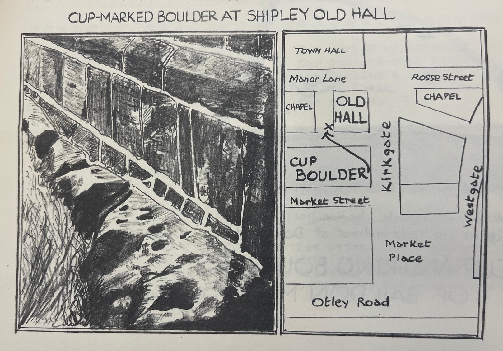
From Shipley town centre open market, take the Kirkgate road up to Saltaire, past the old town hall. On the other side of the road take the little path into the Bowling Club, in the trees (if you hit the church you’ve gone too far). Once standing in front of the bowling green itself, you need to walk along the left-side path. Two-thirds of the way down, now laid in the ivy-covered area below the old quarry face, you’ll find what you’re looking for.
Archaeology & History
I remember first seeking out this carving when I was still at school and wondering how the hell it got here – and believed it to be a fallen standing stone at the time! It seems that the stone was cut and readied for use as a gatepost instead, at some time long ago.
Close-up showing cups & linesIn its previous locale
The curious cup-marked stone has travelled about a bit, somehow. Formerly at the edge of a field in the grounds of Bradford Grammar School 3 miles away (at SE 1523 3583), the fella was then built into the wall of the now-demolished Shipley Old Hall, before reaching its present resting place at the edge of the bowling green. Consisting of around 16 cup-markings with carved lines seeming to link them here and there, it was first mentioned by the late great Sydney Jackson (1955) in an early edition of the Bradford Archaeology Journal. The carving was recently included in the Boughey & Vickerman (2003) survey, where they described it as,
“Medium-sized fairly smooth grit rock with coarse line down top, probably natural, evidence of quarrying on edge. Sixteen or seventeen cups, one with a groove out has a deeper cut within it and twelve of the others are linked in pairs by short grooves. This has been interpreted as feathering for quarrying, but the grooves are across the line of likely split, rather than along it.”
And for those of you who live nearby: if you check this out, see if you can locate an earthfast boulder near here which I recall having a cluster of distinct cup-marks running on top of the rock along one side. I couldn’t find it when I looked a short while ago, it’s not in the archaeology survey lists, and it remains lost—in the heart of Shipley no less!
References:
Boughey, Keith & Vickerman, E.A., Prehistoric Rock Art of the West Riding, WYAS: Wakefield 2003.
Jackson, Sydney, “Cup-Marked Boulder, Shipley Old Hall,” in Bradford Cartwright Hall Archaeology Group Bulletin, 1:10, 1955.
ON the A59 Harrogate to Skipton road, right on top where it crosses the barren moors, get to the parking spot right near where the road levels out at the highest point (2-300 yards past the turning to the derelict Dovestones Quarry). From here, go thru the gate onto the moor for about 100 yard. Then turn straight east (left) for another few hundred yards till y’ reach the spot marked as Gill Head Peat Moor on the OS-map. This small standing stone (right) is where you need to start – the other remains continue east of here.
Archaeology & History
Richard’s original photo, with walling clearly visible
The discovery of this site began in April 2005, when rock art student Richard Stroud and I were exploring the moors here and he called our attention to what seemed like a singular upright standing stone, some 3 feet high, with a debatable cup-marking on top, standing amidst a scatter of smaller stones running north and south from here, implying that the stone may have been a part of some much denuded walling from our ancient past. But we weren’t sure—and simply noted its location (at SE 13378 54924) and carried on our way. But in revisiting this site after looking at some old archaeology papers, Paul Hornby and I chanced to find a lot more on the burnt heathland running east of here.
The upright stone found by Mr Stroud is certainly part of some ancient walling, but it is much denuded and falls back into the peat after only a short distance. A short distance west of this stone is a small cairn which seems of more recent origin; but due east, along the flat plain on the moorland itself, the burnt heathland showed a scattering of extensive human remains, comprising mainly of walling, hut circles and possible cairns—lots of it!
One issue we have to contend with on this moorland is the evidence of considerable peat-cutting in places, which was being done on a large scale into the Victorian period. Scatterings of medieval work are also found across this moor, in places directly interfering with little-known Bronze Age monuments in the middle of the remote uplands. There is no doubt that some of these medieval and later workings have destroyed some of the uncatalogued prehistoric archaeological remains on this moor. But thankfully, on the ridge running west to east along Gill Head to above the source of the Black Dike, scattered remains of human habitation and activity are still in evidence. The only problem with what we’ve found, is the date…
Two rows of straight walling, with stone scatter all roundAnother overgrown curve of walling
In 1960, Mr J. Davies first mentioned finding good evidence of flint-workings at a site close by; then described his discoveries in greater detail in the Yorkshire Archaeological Journal (1963) a few years later — but contended that the remains were of mesolithic origin. A few years earlier, Mr D. Walker described a similar mesolithic “microlith site” a bit further north at Stump Cross. Earlier still, Eric Cowling (1946) and others had made similar finds on these and adjacent moors. Yet all of them missed this scatter of habitation sites, perched near the edge of the ridge running east-west atop of the ridge above the A59 road. It’s quite extensive and, from the state of the walled remains, seems very early, probably neolithic in origin.
A number of small hut circles, 2-3 yards across, are scattered amidst the heather, with lines of walling—some straight, some not—broken here and there by people who came to gather their peat for fuel. The walling and hut circle remains are very low to the ground, having themselves been robbed for stone it would seem. The area initially appeared to be little more than a mass of stones scattered across the Earth (and much of it is), but amidst this are very clear lines of walls and circles, although they proved difficult to photograph because of the excessive growth of Calluna vulgaris.
Curious man-made structure in dried peat-bog
A couple of hundred yards south there are remains of one of the many dried black peat-bogs—with one large section that has been tampered with by humans at some point in the ancient past. Over one section of it there has been built a small stone path, or possible fish-trap; plus elsewhere is a most curious rectangular walled structure (right) obviously made by people a long time ago. Also amidst this dried peat-bog are the truly ancient remains of prehistoric tree-roots emerging from the Earth, a few thousand years old at least – and perhaps the last remnants of the ancient forests that once covered these moors.
How far back in time do all these walled remains take us? Iron Age? Bronze Age? Or much much further…? Excavations anyone!?
References:
Cowling, Eric T., Rombald’s Way, William Walker: Otley 1946.
Davies, J., “A Mesolithic Workshop in Upper Wharfedale,” in Bradford’s Cartwright Hall Archaeology Group Bulletin, 5:1, 1960.
Davies, J., “A Mesolithic Site on Blubberhouses Moor, Wharfedale,” in Yorkshire Archaeological Journal, part 161 (volume 41), 1963.
Walker, D., “A Site at Stump Cross, near Grassington, Yorkshire, and the Age of the Pennine Microlith Industry,” in Proceedings of the Prehistoric Society, volume 22, 1956.
Stone Circles (destroyed): OS Grid Reference – SE 170 810
Archaeology & History
I was hoping to get a Northern Antiquarian team to explore this arena before moving to Scotland, as I lived in hope that we might uncover some remains of an important cluster of megalithic rings in this quiet North Yorkshire area — but we didn’t manage to get here. So this short profile is one based purely on texts.
A mile east of the standing stone and impressive cup-and-ring carvings of West Agra, was once to be found several stone circles — according to John Fisher (1865), who told us about them in his magnum opus on the history of the region. Not to be confused with the giant Druid’s Temple a couple of miles south, Fisher was contextualizing them with the “huge circles of upright stones” which our great heathen ancestors built. Although he made some mistakes trying to link the local place-names with these stone circles (a common pastime of Victorian writers), his remarks still make interesting reading. He told that,
“In this parish there are places which fully answer to this description, as well in situation and appearance, as in the names which they still bear. I refer more especially to Healey-Baals, Beldin Gill, and Baal Hill, which latter place is situate either upon or near to the range of hills known by the name of Healey-Baals. The very name of Baal-Hill, without reference to its appearance or locality, indicates that the place is a hill dedicated to the worship of the heathen god Baal; and the name Healey-Baals, according to the interpretation which I put upon these words, is, if possible, still more conclusive of the matter. I take it that the name of Healey is derived from Heil, holy or sacred, and ley, land consisting of fallow-ground, pastures, or meadows. If, therefore, I am right in my interpretation of the name of Healey, then Healey-Baals means simply land sacred to Baal. This supposition is strengthened by the circumstance of circles of upright stones having recently existed near to the place, and from ancient relics which have been found within the parish, and at but a short distance from Healey and Healey-Baals, which are supposed to have been used in the mystical rites of the Druids or priests of Britain, for at least antiquaries can assign no other use to them…”
There are very few other references I can find that tell of these lost stone circles. Edmund Bogg (1906) mentioned them briefly, saying that between Fearby and the hamlet of Healey a mile west, “there were formerly circles of upright stones and other relics suggestive of druidical origin.” But there’s little more.
In exploring the local field-names we find that three of them here carried the name “Standing Stones” – which seems to tell us where once we could find these old stones. It may be possible that some of the stones were removed into the hedgerows at the sides of the fields.
Folklore
Fisher told of the local tradition of quarterly fire ceremonies close by, which he thought may have related to religious practices at the stone circles, telling:
“There are traditions, too, which have been handed down to us, to the effect that the heathen custom of making feasts and Baal-fires (which although unknown to the persons making them, were in truth so made in honour of Baal) have been continued until very recent times in this district — and especially in Nidderdale — the remembrance of which is transmitted to us in the annual feast which is still held at Healey.”
References:
Bogg, Edmund, Richmondshire and the Vale of Mowbray, James Miles: Leeds 1906.
Cunliffe-Lister, Susan, Days of Yore, privately printed: Bath 1978.
Fisher, John, The History and Antiquities of Masham and Mashamshire, Simpkin Marshall: London 1865.
Smith, A.H., The Place-Names of the North Riding of Yorkshire, Cambridge University Press 1928.
Follow the same directions as if you’re visiting the largest and most ornate of the Buck Woods carvings. From here, about 10 yards ahead of you, roughly north, you’ll see another stone, less than half-size of Buck Woods 1, moss-covered and not rising too much out of the Earth. It’s not difficult to find once you’ve located the largest of the Buck Woods stones.
Archaeology & History
A cup-and-half-ring
Another of the small cluster of little-known prehistoric carved stones in this woodland on the edge of Bradford, not in the Boughey & Vickerman (2003) survey. This however is possessed of a cup-and-half-ring, with other seemingly carved ingredients fusing onto natural aspects of the rock. The design is found on the highest part of the stone; and whilst the main cup is easy to make out, the encircling half-ring is slightly troublesome.
…and from another angle
There are two distinct lines running down one side of the rock, both seemingly natural, but they may have been added to—it’s difficult to say with any certainty. Certainly the one closest to the cup-and-half-ring has the carved line etched to meet the natural geological feature, as you can just make out in the photos here. There also seems to be other carved features surrounding the central design, with other marks round the main cup, almost suggesting that a complete ring was being made, but never accomplished. It’s an odd one. If I’d have stripped the moss from the stone I could have seen the design in greater detail, but I’ve gotta bittova soft spot for mosses and lichens, so left it alone!
Follow the same directions as if you’re visiting the largest and most ornate of the Buck Woods carvings. From here, walk 10 yards to the Buck Woods 3 carving, then about the same distance forward again until you reach the low lines of (what looks like) Iron Age walling running roughly east-west through the trees. Walk 10-20 yards east along the walling until a gap or entrance appears – and on the other side where the walling starts again, check the 2nd or 3rd rock along, beneath the mosses.
Archaeology & History
More simple cup-marks
There are no previous references to this small cup-marked stone, whose cups are on the topmost surface of the stone in this ancient stretch of walling (into which some vandal has recently carved his name, ‘Hunt’). It’s another one for the purists amongst you though, as we only have 2 or 3 cupmarks here, as the photos show – with just one which I can say is a certainty. Curiously the other two look, for all the world, as if they’re mollusc cups!—but considering you’re about 50 miles from the sea, this seems a little unlikely. Worth having a look at when you’re checking the other four carvings close by.
Follow the same directions as if you’re visiting the largest and most ornate of the Buck Woods carvings. Once there, notice the green field on the other side of the wall less than 50 yards away. Walk towards the wall, about 20 yards from the Buck Woods 1 carving, keeping your eyes peeled for a flat mossy stone. You’ll find it!
Archaeology & History
Close-up of the cups
A nice simple, almost cute cup-marked stone—not included in the Boughey & Vickerman (2003) survey—with three simple cups running almost in a straight line from the middle of this long stone to its outward, eastern edge. One of the good features of this and its associated carvings is the setting amidst which it’s found. We tend to associate these carvings with open moorland, where many now live, but when they were first carved they were surrounded by woodland and much more: important ingredients relevant to understanding the nature of these curious carvings…
From Ilkley, take the Cowpasture Road up past Cow & Calf rocks, the hotel and along the moorside. A few hundred yards further, just before the next farm-building on your right, walk up the Rushy Beck path to the top. Crossing the stream at the top, now walk diagonally south-ish into the heather for some 200 yards, a short distance before the hillside begins to rise up again onto the next ridge. Remains of this ‘enclosure’ is all around you!
Archaeology & History
When the normal moorland vegetation covers this prehistoric site, you’d barely know there was anything here apart from various rocky rises and undulations in the ground and perhaps, if you were seeking out old stuff, what would seem to be lines of stone walls bending away onto the moor. But when the heaths have been burnt back, a whole new vista unfolds itself! You see before you a fantastic, well-preserved, unexcavated prehistoric enclosure, whose origins are probably neolithic, but whose history and use stretched through the Bronze Age and into the Iron Age—and it’s not alone! East, west and south of this particular enclosure, other prehistoric walled structures are found stretching all across the landscape hereby, structurally similar and also used over very long periods in prehistory. For antiquarians and historians alike, this is a truly impressive place indeed. In all honesty, the description I give here does not do the place justice!
Northwestern section of enclosure walling
Things like ‘settlements’ and ‘enclosures’ are traditionally relegated by purist archaeologists to be little more than domestic or utilitarian sites: places where our ancestors kept cattle; or were used for defensive purposes; or lived for long periods of the year. Of course, these simple ideas are effective and true at some places; but here at Woofa Bank—in this particular enclosure—something more than just domestic activity was enacted, and over the period of many centuries by the look of things. We surmise this by the incidence of at least fifteen cup-and-ring stones being found within the enclosure itself; and at its very centre is a small standing stone, not previously recorded, that has perhaps five petroglyphs around it. The presence of such a large cluster of cup-and-ring stones close together within the enclosure would seem to suggest ritual activity.
Carved rock & central stoneClose-up of, dancing anthropomorphic figure?
One of the carvings at the centre of the enclosure (listed in the Boughey & Vickerman survey as Carving 372) has been suggested to represent a dancing human figure (the image here shows the anthropomorphic element), which it may well be. The incidence of this central stone and its surrounding petroglyphs has important magico-religious implications, relating it as a site used for creation myth narratives and repetitions (transpersonal explorations at this site may prove worthwhile). The wider extended enclosure with more petroglyphs contained inside it, suggest that additional ritual performances were enacted here; these may have had something to do with the cluster of prehistoric tombs scattered on the moorland plain 100 yards to the west, but we might never know.
Easternmost standing stone
It seems that the walled enclosure itself was constructed around the earlier cup-and-ring stones, probably many centuries later—but we need excavations here to give us more precise details. Much of the enclosure walling itself has the hallmarks of being late Bronze Age to Iron Age, whilst we know that prehistoric rock art can date back into the neolithic period; and from this period Eric Cowling (1946) reported that, at Woofa Bank, “at the western end of the ridge,” just above this enclosure, a neolithic flint site existed.
Cowling’s 1946 plan
Cowling (1946) himself was one of very few archaeologists to even mention this impressive site, in a section exploring the “Iron Age” sites along Green Crag Slack at the eastern end of Ilkley Moor. He wrote:
“At the other end of the site under the shadow of Woofa Bank and near the source of the Rushy Beck, is another D-shaped enclosure apparently unfinished. The plan is of a circle with a flattened side and does not exceed twenty-four yards across in any direction. Here the enclosing wall shows five or six courses at the lower end side and a simple entrance to the west.”
Western entrance to enclosureStone marking eastern entrance
Though Cowling’s measurements are way out! The enclosure itself is much larger than he describes. For the most part, three-quarters of it give the impression of it being a large oval shape, but the design and outline of the walling changes on its southeastern side and kinks inward, in an arc, to eventually meet the walling in the middle eastern section. Its entire circumference measures approximately 220 yards all the way round; it is 65 yards across east-west; and about 61 yards north-south. The average height of the main walling is between 2-3 feet tall, and is made up of many large rocks, some of them positioned upright as standing stones, all packed together with earth and countless thousands of smaller stones. The walling itself is between 2-3 yards wide in many places and has two main entrances: one near the middle of the western wall and the other almost opposite to the east. The eastern entrance is marked by a standing stone between 3-4 feet tall. No gaps are visible at all on the northern curved section of the enclosure. On the overgrown southern edges, not all of the walling is visible and much of it is overgrown. On the whole it’s still very much as Cowling found it, with the arc of walling in this part of the enclosure difficult to make out clearly. There is also another line of walling that runs off to the east, beyond the main enclosure itself.
Carved rock in western wall
The clearer, more visible western line of walling, running south of the entrance on that side, has a large singular cup-and-ring stone laid right along its axis (carving 366 in the Boughey & Vickerman [2003] survey), a short distance before the walling changes direction east-west and runs along the bottom of the slope.
Folklore
Tradition tells that the tribal people from this site were involved in a battle with the Romans along this moorland plain.
…to be continued…
References:
Bennett, Paul, The Old Stones of Elmet, Capall Bann: Chieveley 2001.
Boughey, Keith & Vickerman, E.A., Prehistoric Rock Art of the West Riding, WYAS: Wakefield 2003.
Cowling, Eric T., Rombald’s Way, William Walker: Otley 1946.
Eliade, Mircea, Images and Symbols, Harvill Press: London 1961.
Hedges, John (ed.), The Carved Rocks on Rombalds Moor, WYMCC: Wakefield 1986.
Size, Nicholas, The Haunted Moor, William Walker: Otley 1934.
From Threshfield, go up Skirethorns Lane for about 1/2 mile, where the lane takes a sharp right. Continue uphill for nearly 2 miles to a metal gate. Go through the gate into the fields on your left where you’ll see this pair of curious standing stones ahead of you (if you keep walking uphill in the same direction, you’ll reach the impressive Hammond Close enclosure above you).
Archaeology & History
There seem to be no references in either archaeology or geology texts about this site which, when you approach it and consider the prevalence of other prehistoric sites all round you, strongly suggests that they are either archetypal standing stones, or the remains of a collapsed cairn, with the surrounding mound removed. This is certainly the case at the Druid’s Altar or Bordley Circle visible a few hundred yards west of here, on the same grassland plain.
The stones alone, looking north
As you can see in the photos, the stones here are 4 feet tall and stand in isolation from the excess of neighbouring settlements and enclosures. A scatter of small stones—perhaps packing stones, perhaps the remains of cairn-spoil—is evident at the foot of the stones. It was initially thought that the uprights here could have been the remains of enclosure or settlement walling, as we find an excess of such remains on the hills here, but this isn’t the case. Other unrecorded prehistoric remains scatter this part of the countryside.
Follow the directions to reach the Little Skirtful of Stones giant prehistoric cairn. Once here, look for the singular rocks out of the many thousands which make up the giant cairn, mainly from the middle to the northern-half of the cairn, and you’ll find them amidst the mass!
Archaeology & History
Cup-marking near the centre of the cairn
Despite the task sounding difficult, it’s not too hard locating the cup-marked rocks within this giant cairn. As I recall there should be five of them, though the Boughey & Vickerman (2003) survey only list four and I only have photos of four of them as well…so I reckon age is probably getting to me at last! There could very well be more of them amidst this massive tomb. But we certainly can’t rely on the Boughey & Vickerman (2003) survey for the carvings at this site as they give the wrong grid references for each of the cup-markings listed, with them all being a kilometre east from the site of the tomb itself! Awesome! God knows what their cartographer was on when he did the profiles for these carvings! (there are plenty of spliff-butts scattered over this moor…..) Not only that, but the position they cite of the relative cup-markings within the cairn are also wrong.
Another portable stoneCup-mark at outer edge
But for those of you who like to know the archaeological data, here’s what was said: Carving 391a is a “small rock towards SW edge of cairn, with single worn cup”; but this stone is actually closer to the northern section of the cairn. Carving 391b was told to be a “small dome-shaped rock at extreme S edge of cairn with single, small clear cup at top of dome.” This again is more on the northern section of the cairn, away from the centre. Carving 391c was described as a “small oval, rounded rock at N edge of cairn, with single, broad, shallow worn cup.” Whilst carving 391d which was told to be a “small rock at SSE edge of cairn, with single small worn cup.” However, we have to take into account that any errors about their position may simply be down to the fact that the small rocks have been moved.
Smoothed cupShowing different rock-type
As you’ll see in the photos here, one of them is actually near the very centre of the cairn, with the cup-marking etched into the edge of the small rock itself. I’m not quite sure if this is the additional fifth carving in the cairn, or whether it’s one of those wrongly ascribed as being in another position. It’s hard to tell, as the local Ilkley Archaeology team don’t publish their findings and information on-line as they should do and unless you’re in their little club they’re hard to get info out of. So this will have to do for the time being I’m afraid. Also note how one of the cup-marked stones is of a rock-type different to the local millstone grit.
Folklore
The creation myth of the Little Skirtful itself tells that the giant Rombald (who gives his name to the moor) was in trouble with his wife and when he stepped over to Almscliffe Crags from here, his giant wife – who is never named – dropped a small bundle of stones she was carrying in her apron. Harry Speight (1900) tells us of a variation of the tale,
“which tradition says was let fall by the aforementioned giant Rumbalds, while hastening to build a bridge over the Wharfe.”
Variations on this story have said it was the devil who made the site, but this is a denigrated christian variant on the earlier, and probably healthier, creation tale. Similar tales are told of the Great Skirtful of Stones, 500 yards south.
The cluster of portable small stones with single cup-marks on them relates to traditions found in other cultures in the world where, usually, women would carry such items in their aprons and deposit them at or on the tomb, in honour of the ancestor or spirit known to be resident at the sacred site. The folklore found at the Little Skirtful (and Great Skirtful too) of Rombald’s wife dropping the rocks here and forming the giant tomb, probably derive from variants of this same honorary practice.
References:
Bennett, Paul, The Old Stones of Elmet, Capall Bann: Chieveley 2001.
Boughey, Keith & Vickerman, E.A., Prehistoric Rock Art of the West Riding, WYAA 2003.
Cowling, Eric T., Rombald’s Way, William Walker: Otley 1946.