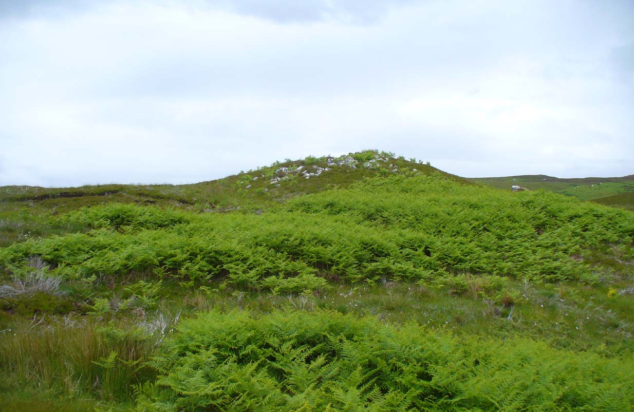
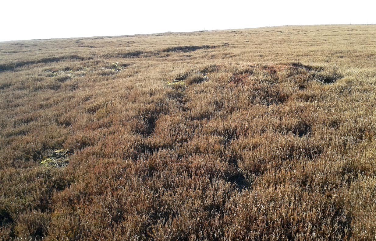
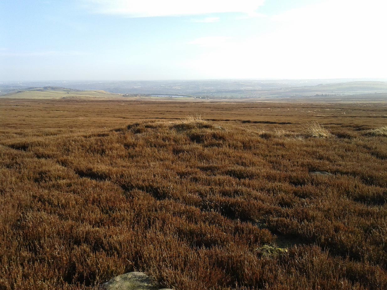
Along the A836 road a mile east of Bettyhill, a track goes south onto the moors just before Loch Salachaidh. Walk along here for several miles, past the windmills, past a small quarry on your left, and a hundred yards or so along, to the right of the track, you’ll notice a rounded hillock covered in stones and rock on the top (aswell as bracken in the summer and autumn). That’s the spot!
Archaeology & History
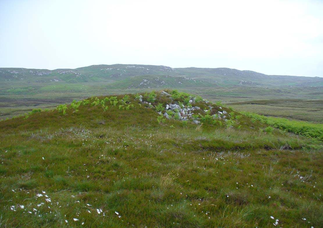
Achadh Thaibstil cairn
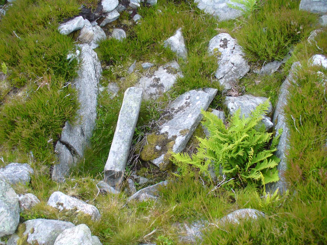
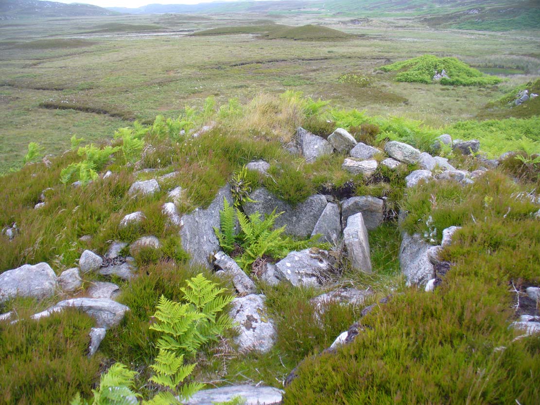
This little-known cairn, close to the prehistoric hut circles on the other side of the track, is a medium-sized Neolithic or Bronze Age monument. Not included in Audrey Henshall’s (1995) survey of the region, the tomb was built upon a small natural rise with the usual thousands of small and medium-sized stones rising up 4-5 feet high. Near its crown we find an exposed chamber, typical of chambered tombs, measuring more than a yard across and two yards long, with flat slabs defining its sides. It appears that the inner ‘chamber’ may have been split into two sections, as an oblong slab of stone runs parallel down the central ‘chamber’ a third of the way across. The Canmore account simply tells how the cairn is on low knoll and
“measures about 10.5m in diameter and 1.0m high. It has been opened and a centrally placed slab lined cist revealed, the southern side of which is missing. The cist measures 1.4m east-west, with the east and west slabs 1.2m long and 0.6m high.”
Looking down into the chamber
From the chamber, looking N
On the horizon to the far north, the peak of the giant tomb known as Fiscary 2 rises up, indicating the cardinal direction. This may have had geomantic significance, as ‘north’ signifies Death and darkness: the symbolic point where light never emerges; the point linked to the North Star, Alpha Draconis in the neolithic era, or Polaris in our present Age: the point to and from which shamans travel into the Land of the Gods. These elements may or may not have been relevant here.
References:
Henshall, Audrey S. & Ritchie, J.N.G., The Chambered Cairns of Sutherland, Edinburgh University Press 2005.
Tumulus (destroyed): OS Grid Reference – SP 2946 3090
Archaeology & History
Only known drawing of Gough’s Barrow
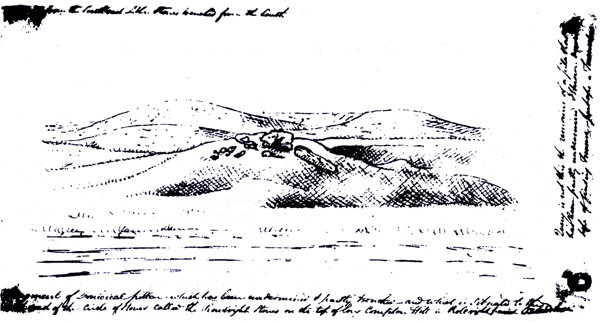
In days of olde there were heathen sites around the edges of the beautiful Rollright Stones complex that have sadly fallen prey to the intensive agriculture of more modern ‘civilized’ times. It’s become the way of things….. One site of importance in this geomythic pantheon was the ‘Gough’s Barrow’—so named after a drawing was done of the site by Richard Gough, editor of the 1789 edition of Camden’s Britannia. As far as I’m aware, it is the only one ever done of this monument. The Oxford archaeologist George Lambrick (1988) saw “every reason to accept the position and details of the barrow”, upon which stood at least two large stones—one of which gained the description of a ‘druidical pillar.’
Stukeley’s 1743 drawing
The same barrow may have been recorded in one of drawings of the great William Stukeley, who visited the Rollright Stones in 1710 and then again in 1723. On the left-side of the adjacent drawing you can see a denuded mound close to the edge of the picture, similar in shape and form to that drawn by Richard Gough. It is probably the same tumulus or barrow. Trial excavations at the site in 1983 looked for any remains of the old tomb, but nothing significant was uncovered. Lambrick estimated that the site probably measured “about 18m wide and 20m long east-west,” and “was a megalithic barrow and was therefore probably Neolithic in origin.”
References:
Bennett, Paul & Chanter, James, The Complete Rollright Stones, forthcoming
Bennett, Paul & Wilson, Tom, The Old Stones of Rollright and District, Cockley Press: Chipping Norton 1999.
Burl, Aubrey, Great Stone Circles, Yale University Press 1999.
Lambrick, George, The Rollright Stones, English Heritage 1988.
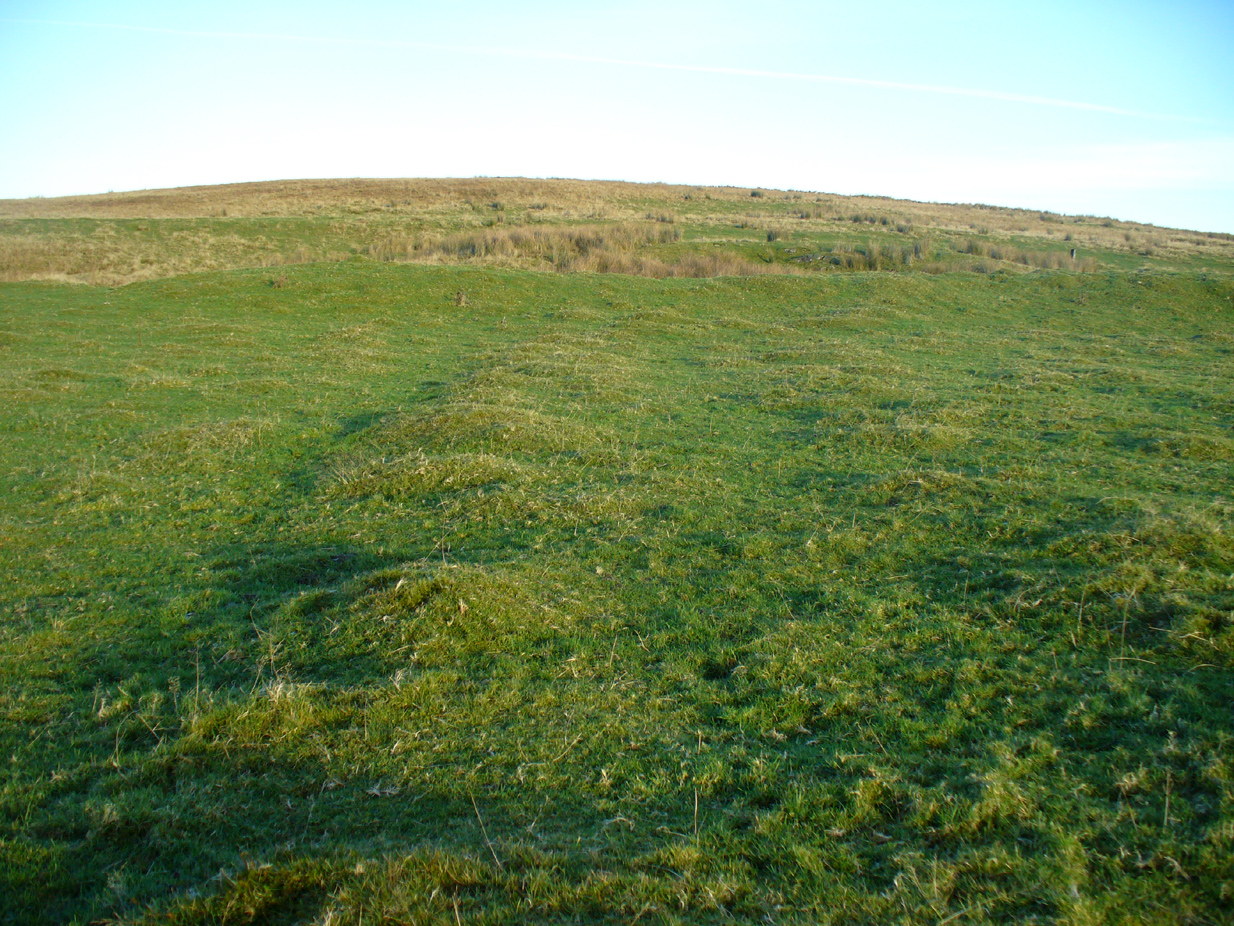
Take the A809 road several miles north out of Glasgow, between Bearsden and Drymen. Once out of the suburban sprawl, passing Milngavie, you’re heading to the famous Carbeth hutters. Before this, note the gold course on your right (east). Park here and cross the road where a gate and overgrown footpath takes you onto the grassy hills. Keep to the fence-side for about 700 yards until it veers downhill. Don’t walk downhill! Keep in the same direction into the short grasses and, veering gradually left, downhill for a couple hundred yards ahead and, across a small boggy area, you’ll note some large upright stones in front of a mound. That’s it!
Archaeology & History
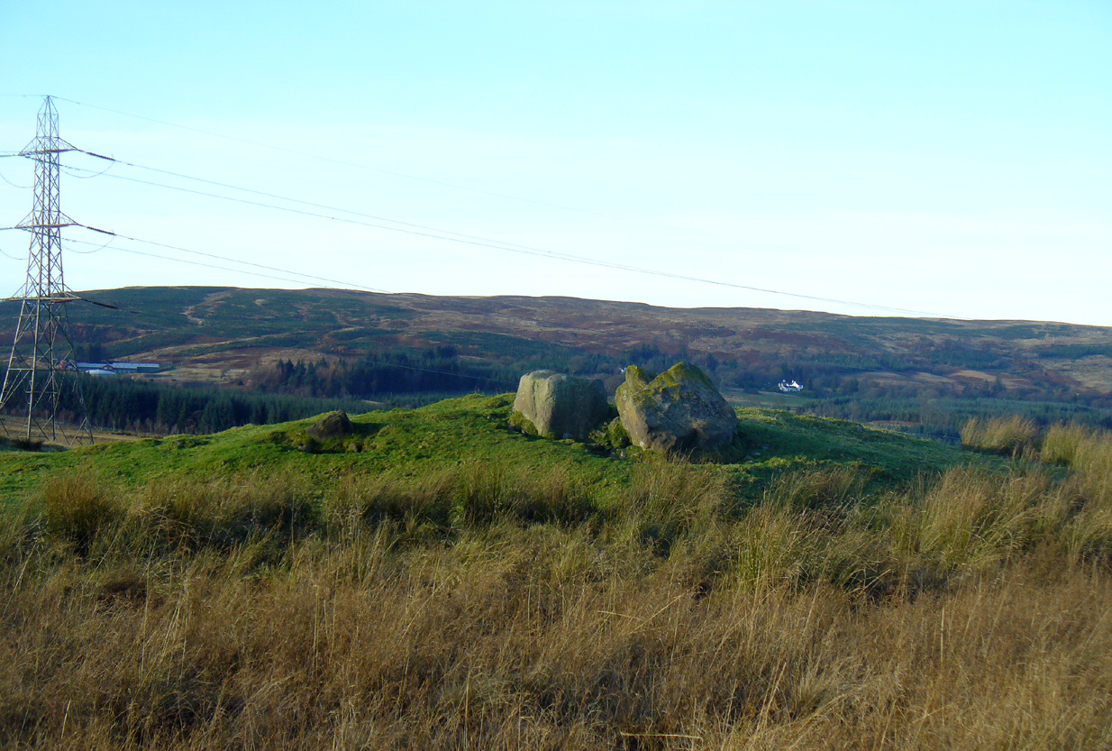
The SE stone ‘entrance’
There is no previous reference to this site which was found, quite fortuitously, by Nina Harris of Organic Scotland a few years ago. She visited the site a number of times, puzzling over the curious line of possible standing stones at the edge the grass-covered mound—wondering if it was anything at all. A few months ago she took us to see the place…
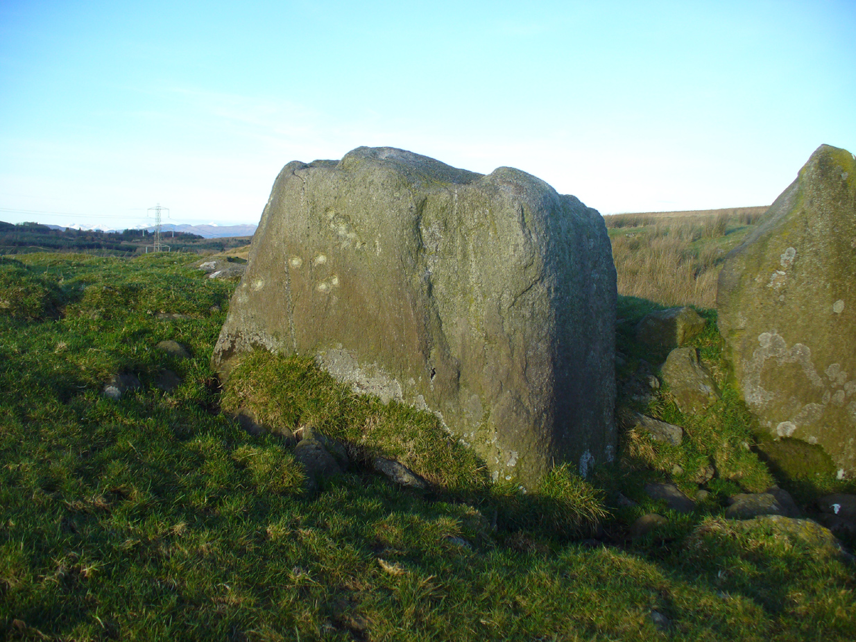
Modern gunshot cup-marks on entrance stone
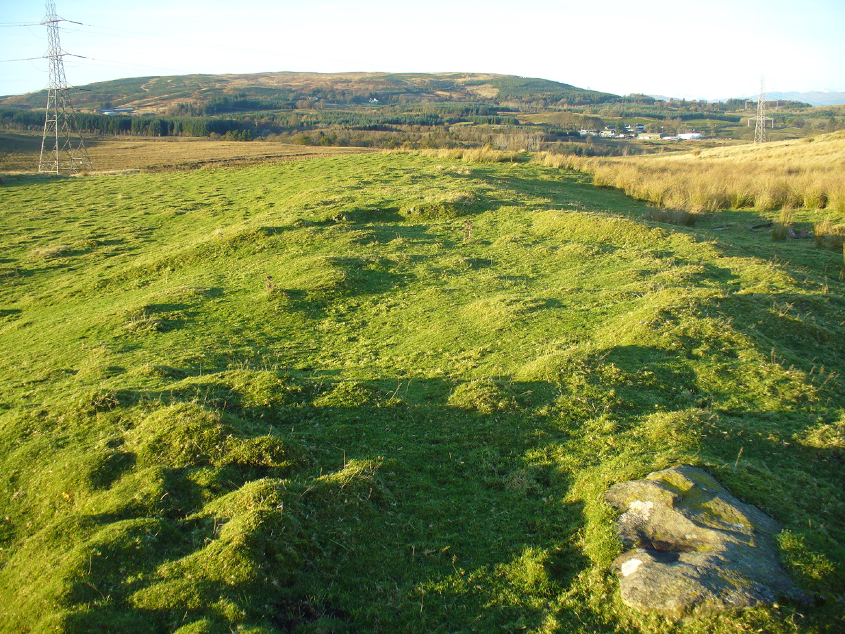
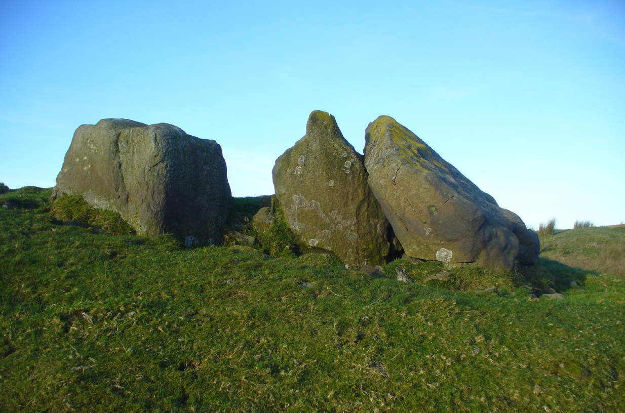
The site has been damaged and elements of it have been stripped for walling that are visible all around here. The cairn is more than 55 yards in length, running from its southeastern stone ‘entrance’ to the gradually diminishing northwestern edges. At its widest it is 14.6 yards (13.5m) across, near its southeastern end. The main three standing stones at its entrance are four-feet tall at the highest, with one of them leaning upon another; an adjacent fourth stone, smaller than the main three, is more embedded into the cairn mass a couple of yards away. Cup-marks on one of the three larger uprights here are recent gunshot marks; whilst the possible cup-marks on the largest upright are natural.
Line of ancient wall runs up and over the cairn
Looking NW along the cairn mass
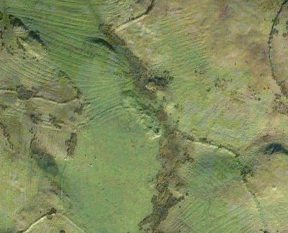
In standing on top of the long cairn, just above the large stones, you can see how sections of it have been stripped away. Just beneath the surface is a line of internal walling, with what seems to be another one running parallel. These run for a few yards until we reach a large circular depression within the overall cairn mass, a yard deep and 6-7 yards across; on the northern edge of which we can clearly see a section of walling beneath the surface. When we look at the aerial view of this on Google Earth, we can clearly see how this walling actually begins way outside of the cairn mass itself, as a much denuded line of it (probably medieval in origin, though possibly Iron Age) curves across the grasslands from the west, crosses the long cairn and re-emerges on the other side of the adjacent boggy ground at its southeastern edges and continues on its way: indicating that the cairn mass beneath the wall is much older than the walls running across it.
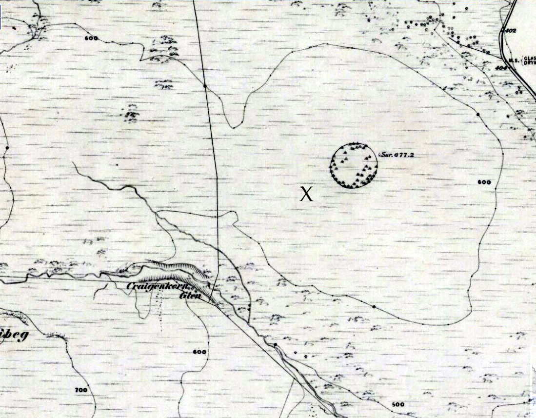
“X” marks the spot!
The main three ‘entrance’ stones
Audrey Henshall (1972) described the existence of another prehistoric chambered tomb like this one at Cairnhowit 1.95 miles (3.14km) southwest, and we find the Stockie Muir long cairn 3.12 miles (5.02km) to the northwest, clearly showing that the incidence of this monument is not an isolated one. Others can be found not much further away. The existence of the raised geological plate known as Carneddans Wood just over a mile south may have once been home to another chambered cairn.
Please note that the grid reference for this site fixes on the southeastern section of the cairn, where the upright stones are.
References:
Henshall, Audrey S., The Chambered Tombs of Scotland – volume 2, Edinburgh University Press 1972.
Acknowledgements: First and foremost to Nina Harris, for unknowingly finding the place; also to Paul Hornby and Marion Woolley for visits to the site.
Barrow (destroyed): OS Grid Reference – SU 6018 5013
Archaeology & History
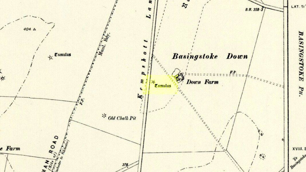
Downs Farm tumulus on 1897 map
On the western edges of Basingstoke, at Kempshott, could once be found this ancient site—destroyed many decades ago. It was one of number of similar prehistoric burial mounds in the area. First described in a listing of tumuli by Mr Andrews (1898) who told us that it was “oval” in shape, the monument was completely destroyed in 1939 and according to the Royal Commission (1979) lads,
“its site now lies beneath a house at the southwest corner of Kempshott Lane and Homesteads Lane.”
When the house where it once stood was being constructed, a collared urn was recovered from the tomb, which the Royal Commission thought indicated “that the monument (was) likely to have been of early Bronze Age date”—but obviously we cannot be sure. The site was listed in Leslie Grinsell’s (1979) extensive survey of prehistoric tombs in the area, in which he suggested it may have been a long barrow.
References:
Andrews, S., “A Short List of Some Tumuli in North Hampshire,” in Proceedings of the Hampshire Field Club & Archaeological Society, volume 4, 1898.
Grinsell, Leslie V., “Hampshire Barrows – part 3,” in Proceedings of the Hampshire Field Club & Archaeological Society, volume 14, 1940.
Royal Commission on Historic Monuments, England, Long Barrows in Hampshire and the Isle of Wight, HMSO: London 1979.
Willis, G.W., “Bronze Age Burials round Basingstoke,” in Proceedings of the Hampshire Field Club & Archaeological Society, volume 18, 1953.
Tumulus (destroyed): OS Grid Reference – TA 0584 6128
Archaeology & History
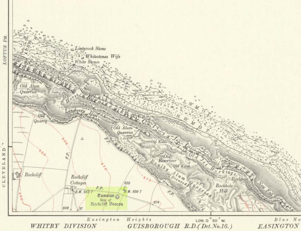
Ruston Beacon tumulus on 1854 map
A fallen tumulus that once marked the southwestern side of the village boundary line, and was once adjacent to the prehistoric Green Dikes earthworks that once passed here. Sadly however, sometime early in the 20th century, this ancient burial mound fell victim to usual ignorance of arrogant land-owners who place money ahead of history and local tradition and it was ploughed-up and destroyed. Thankfully we have an account of the site in J.R. Mortimer’s (1905) incredible magnum opus. Listing it as ‘Barrow no.272’ in the number of tombs excavated, he told us that:
“It is situated on elevated ground about half-a-mile (south)west of Ruston Parva. On September 20th and 21st, 1886, it measured about 70 feet in diameter and 2 feet in elevation; and had originally been several feet higher, as an old inhabitant remembered assisted in removing its upper portion, which was carried away and spread on the surrounding land many years previously. At the base of the barrow, near the centre, was a long heap of cremated bones which had been interred in a hollow log of wood with rounded ends, about 3 feet in length and 14 inches in width, well shown by impressions in the plastic soil, and by the remains of the decayed wood. The heap of bones was rather large and probably consisted of the remains of more than one body. No relic accompanied them. Several splinters and flakes of flint were picked from the mound.”
The tumulus (as its name implies) became a spot besides which one of East Yorkshire’s many ancient beacons were built. In Nicholson’s (1887) survey of such monuments, he told that
“the modern beacon, apparently, stood on the site of the old one, on the high ground in the angle of the road from Driffield to Kilham. It was a prominent object and would be well-known to the coachmen and guards…for it stood on the side of the road from Driffield to Bridlington. Mr John Browne, of Bridlington, remembers it; and says, ‘It would be the last of the beacons that remained in this district and was removed between fifty and sixty years ago. My recollection of it is that it was a tall pole, with a tar barrel at the top, and had projected steppings to reach the barrel.”
One of the earliest accounts of the beacon from the late-1500s told that it took signal for its light from the beacon at Rudston, which stood upon one of the Rudston cursus monuments, a short distance from the massive Rudston monolith.
References:
Mortimer, J.R., Forty Years Researches in British and Saxon Burial Mounds of East Yorkshire, Brown & Sons: Hull 1905.
Nicholson, John, Beacons of East Yorkshire, A. Brown & Sons: Hull 1887.
Occupying a prominent position above the ever-closer North Sea, upon which an old beacon was subsequently placed, this denuded prehistoric tomb was first surveyed by the Ordnance Survey lads in 1913, and subsequently in an essay by Messers Hornsby & Laverick (1920) on the ancient sites of Boulby, east of Easington. This was the first one they explored, calling it ‘Mound No.1.” They located it,
“due south of the ‘Soldier’s Garth’ in the east corner of the field called The Falls. It was a cairn with a diameter of 50ft. Two-and-a-half feet northwest of the centre peg, at a depth of 21 inches below the present surface, there was an unaccompanied burnt burial, which occupied a space of 15in by 18in. In a centre cut 7ft 6in by 6ft, at a depth of 3ft 6in, we found much burnt bone and many potsherds of the Bronze Age type, scattered over the whole space of the trench, down to a further depth of 3ft 10½in. In the south corner there were four stones set on edge and running in a direct (straight) line. The interment had been placed upon the clay, the soil of the original surface having been cleaned off. With this burial we found a good flint made from a polished celt and worn smooth at the point—possibly through having been used for striking fire on iron pyrites—many chips and several cupstones.”
The “several” cup-marked stones they describe at the end seem to have been lost; perhaps sleeping in some museum cellar somewhere (does anyone know?).
This cairn was one in a complex of eight that Frank Elgee (1930) suggested may have been laid out deliberately in the form of the constellation of Ursa Major, or The Plough, also known as ‘Charles Wain’.
References:
Brown, Paul & Chappell, Graeme, Prehistoric Rock Art in the North York Moors, Tempus: Stroud 2005.
Crawford, G.M., Bronze Age Burial Mounds in Cleveland, Cleveland County Council 1990.
Elgee, Frank, Early Man in North-East Yorkshire, John Bellows: Gloucester 1930.
Hornsby, William & Laverick, John D., “British Barrows round Boulby,” in Yorkshire Archaeological Journal, volume 25, 1920.
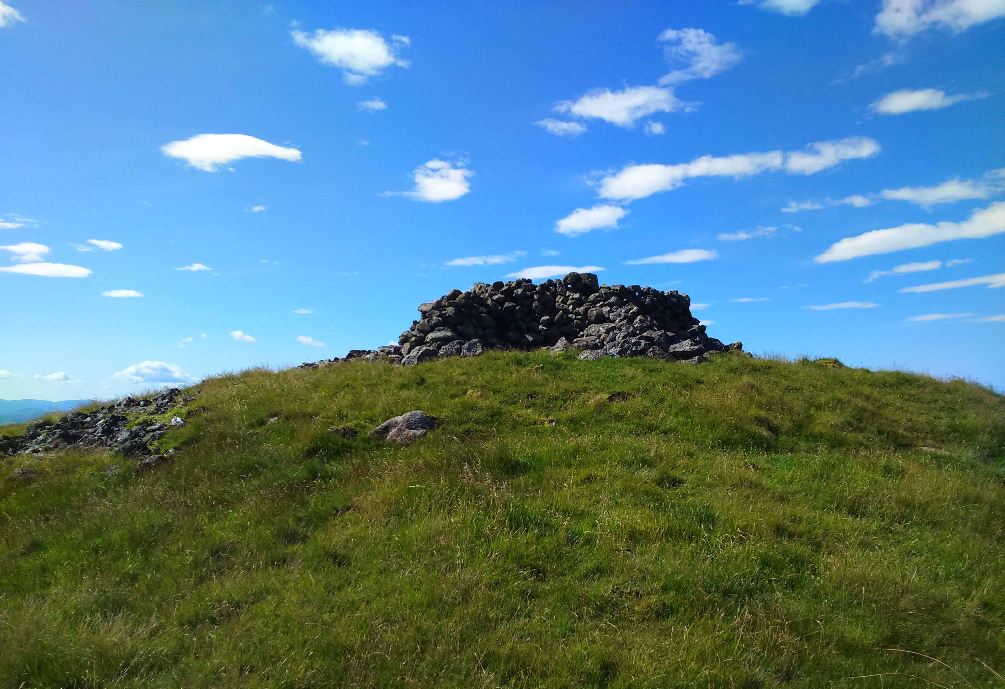
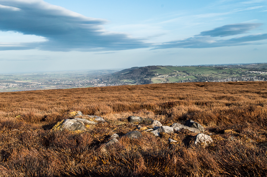
The quickest way here is still a long one. From Gargunnock village, take the road west towards the A811, turning left just before the bend down to the main road, and up through what looks like private estate gates. Walk all the way along this road as if you’re visiting the Leckie broch and its carvings, but keep going, until it becomes a track. Continue into the woods, uphill and out the other side until you have the Gargunnock cliffs rising a few hundred yards ahead of you. On your right a few yards up is a long straight length of walling running to the first set of cliffs. Go up it and up the next rise and the next. When you’re on top of the moors, look for the highest spot close by. You can’t miss it!
Archaeology & History
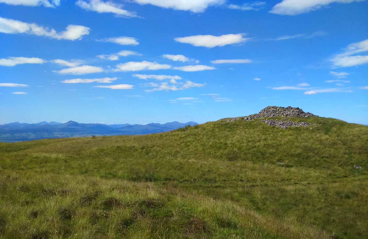
Cairn-edge, looking NW
Nearly 1600 feet above sea level, this seemingly isolated giant cairn sits on the highest point of the Gargunnock Hills, giving a truly fantastic 360º view, looking across a diameter of perhaps 100 miles on a clear day—which is what I was greeted with when I visited. Giant cairns scatter hilltops all across the British Isles, many of them peopled with creation myths of giants, devils and thoroughly animistic creatures! But I can find no such tales here… Equal lackings are in the archaeological texts which, it seems, only catalogued the site in recent years.
Caerlatheron, looking SE
The name of the site is intriguing. The element caer is a fort, but no such ‘fort’ seems to be here. But we’ll come back to that shortly. The element latheron and its variants apparently relates to a mire or swamp (Watson 1926), whose existence to the immediate south and west is considerable (a small loch was once hereby, but its size has decreased over the last 150 years), and it is very boggy across the tops here. When I visited, it was a scorching day (I was fucked by the time I got here!), but in many places the ground was very dangerous to walk over. It was superb! So it seems that the place-name indicates Caerlatheron was ‘the fort by the swamp’. It works perfectly, except that this is listed as a cairn – and it’s a large one at that!
Note the overgrown raised embankment (lower centre)
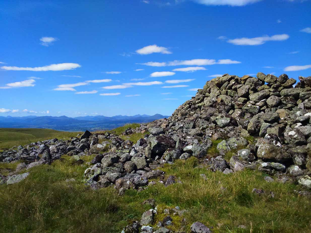
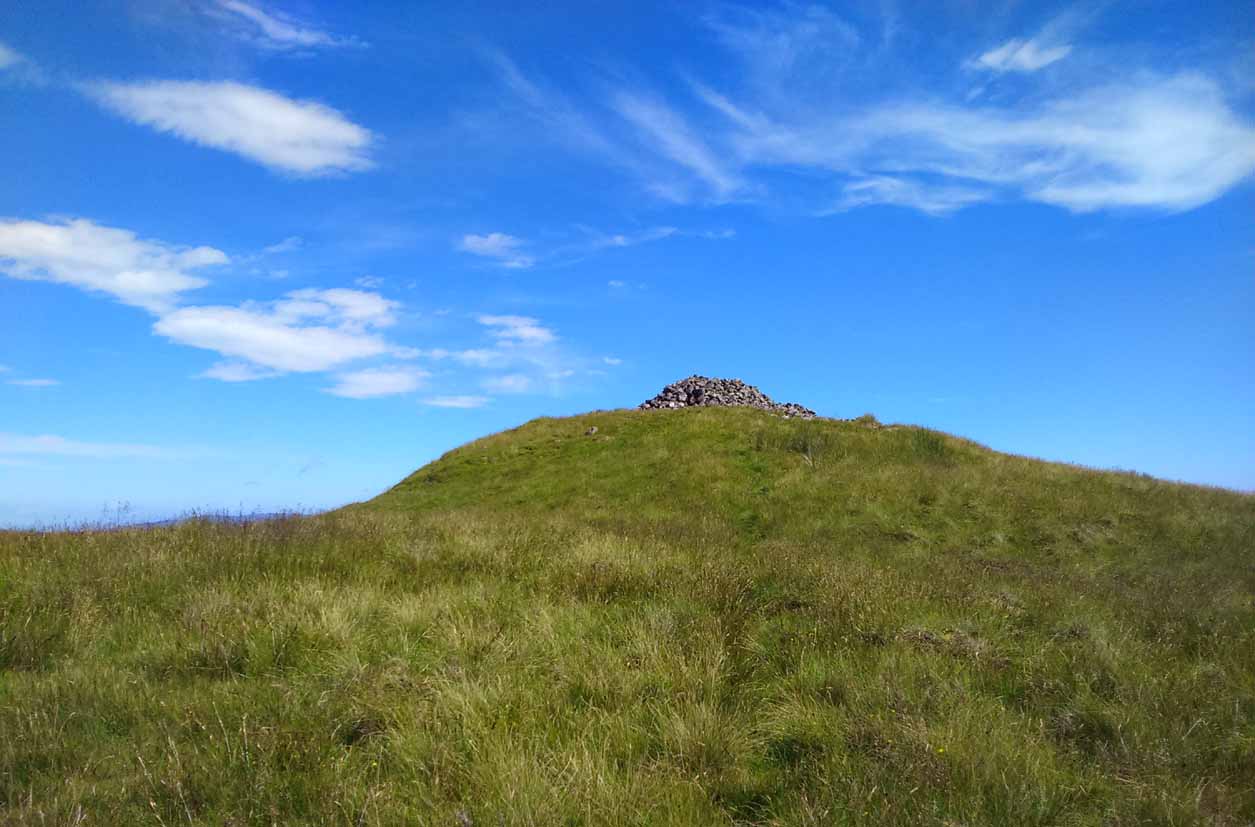
The cairn sites on top of a large mound. This mound seems to be artificial and is between 10-12 feet high. The cairn and mass of rocks on top of the mound (within which is a triangulation pillar) is itself 4-5 feet high—although much of this relates to Ordnance Survey and walkers piling up many of the loose stones to create an enclosure or wind-break to protect any traveller up here in stormy weather. The cairn-pile is 20 yards across at the top, and as you walk around it you become aware that this appears to be slightly raised on top of its parent mound with an evident ’embankment’, particularly on the eastern side. As you follow this round, you lose sight of it completely on the southern edges, which is covered by the extended cairn-mass; but some of it seems in evidence on the northwest and northern side. A number of stones marking this out would seeeem to be in evidence. A few larger flat stones on the south and western top of the cairn might suggest that it was once a chambered cairn – but this is highly speculative. The late great Audrey Henshall never got here; and I don’t know whether the great local archaeologist, Miss Christian MacLagan, ever got her fingers here either, so we don’t have their expertise to help us out.
Caerlatheron, looking ECairn-mass of the huge mound
The mound upon which the ‘cairn’ sits is also intriguing. When walking round and around the bottom of it, you note the unmistakable substantial mass of overgrown rocks, particularly around from the northwest, to north, to northeast, both on the slopes and at the bottom, seeming to imply that the entire mound is artificial. I kept walking up and down and around it, to see if these had simply fallen from the top, but wasn’t 100% sure and wished there was a geologist at hand to tell me, one way or the other. In truth, the shape of the mound from the bottom, from most angles, reminded me of an overgrown broch and not a cairn. And there are a few brochs nearby—the closest of which is just at the bottom of the hill from here: the Leckie broch (I aint done the site profile for it yet, soz….). It was only when I got home and looked for the meaning of Caerlatheron that the ‘broch’ idea came back to me with a little more fortitude, perhaps making sense of it as a ‘fortified structure by the bogs and swamps’. Perhaps… Without an excavation, we may never know for sure.
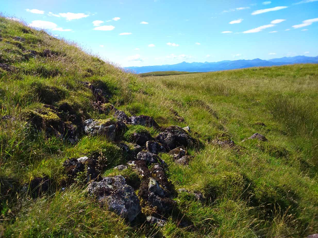
Singular cairn, 350yd NNW
About 350 yards northwest, across truly dodgy swampy ground (walk up here at night and it’ll probably be the last thing you ever do!) is another small singular cairn, made up of quite large rocks, with a few smaller ones filling it up. It looks to be either a shepherd’s cairn, or one for his sheepdog perhaps, a few centuries old. I can find nothing about it in any local history or record-books.
The place is well worth visiting—but it’s a full day out and you’ll be knackered when you get back. However, from here Nature grants us a stunning view of these tiny parts of Her body. It’s well worth the effort!
References:
Watson, W.J., Celtic Placenames of Scotland, William Blackwood 1926.
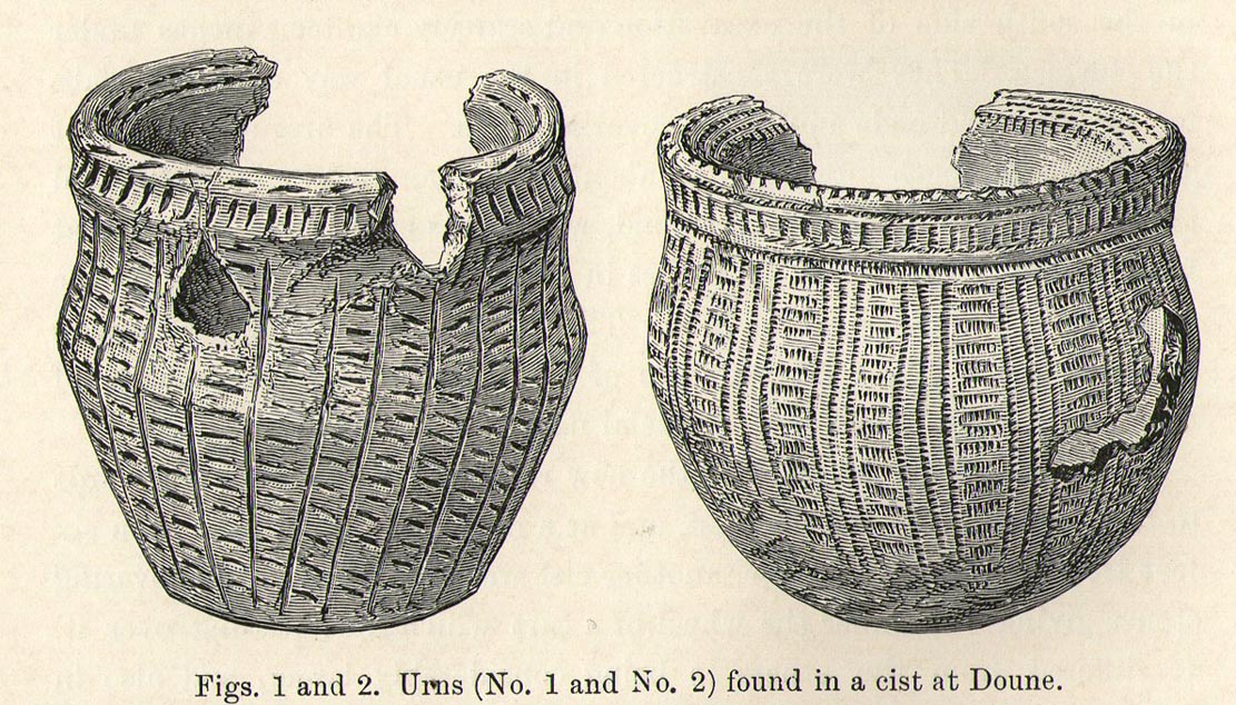
Somewhere in the woodland park, before the area was “ruined”, as Moray Mackay (1984) put it, by “sand and gravel workings”, and within 100 yards of the re-positioned Trysting Stone, there once remained the ruins of ancient tombs—probably neolithic or Bronze Age in nature. The ‘cists’ as they’re known (stone-lined graves), were described in several short articles at the beginning of the 20th century, shortly after their rediscovery. Drawing upon the initial article by Joseph Anderson (1902) in the Scottish Antiquaries journal, W.B. Cook (1904) wrote:
“The doubling of the (railway) line from Dunblane to Callander has necessitated the altering of a road at the Crofts, Doune, and on Tuesday, 8 May, while digging, the navvies came across two stone cists containing bones. The cists were made of stone slabs. On Thursday, the men came on another cist about five feet from the surface. It was 3 feet long and 2½ feet broad, composed of round stones, and a quantity of bones were found in it, and also an urn. Unfortunately a cart-wheel passed over the urn, smashing it. The pieces were, however, carefully collected and cemented and they are now in the possession of Mr Smith, Clerk of Works to the Caledonian Railway Company, Doune. One of the cists first found was quite empty, but the other contained a large number of human bones, the largest about 1½ inches long. The coffins were about 15 inches from the surface, and lay from east to west. They measured 2 feet 9 inches in length, and in breadth and depth about 18 inches. They are constructed of local stone, and near the spot there has been a dyke running from the burgh to the sand holes, as the foundation was visible when the soil was being removed. Some of the stones indicate that a house might have stood near the spot, but there had been no public burying-place nearer than at Kilmadock and at the little chapel of Inverardoch previous to 1784.”
In Mr Joseph’s (1902) article, he told us there wasn’t one, but two urns which, after some considerable effort, were reconstructed. I’m not a great lover of urns misself, although when found in conjunction with the dead, we must ask, what was in them (if anything) when they were placed with the deceased? Food? Herbal beverages? Shamanic potions? In this case, we don’t know; and so all we are left with is Mr Anderson’s description of them:
“Urn No.1 is of the usual type of the so-called ‘food-vessel’, 4¾ inches in height by 5 inches in diameter at the mouth, the lip slightly bevelled inward, and the whole exterior surface ornamented. The ornamentation consists entirely of lines impressed into the soft clay with what seems to have been the roughly broken end of a small twig about ⅛-inch in diameter. On the level of the lip there are two parallel lines of short scorings going completely round the upper surface. On the exterior surface there is a kind of slightly concave collar half an inch in width immediately under the brim, which is ornamented with short perpendicular indentations about a quarter of an inch apart. Underneath the collar the vessel expands slightly to the shoulder and then contracts to a flattened base of three inches in diameter. The part above the shoulder is slightly concave externally, but the scheme of decoration above and below the shoulder is the same, consisting of a series of short impressed lines scarcely half an inch in length ranged round the circumference in horizontal rows about a quarter of an inch apart, and crossed perpendicularly by lines about half an inch apart, not impressed, but scored into the clay. The perpendicular lines above the shoulder are more divergent than those below the shoulder, which converge towards the bottom in consequence of the tapering form of the lower part of the vessel. The paste is coarse, and mixed with small stones; the wall of the vessel is about a quarter of an inch thick, and the colour a reddish brown on both the exterior and interior surfaces, but quite black in the fractures exposing a section of its thickness.
“Urn No.2 is of the same wide-mouthed, thick-lipped form of the so-called food vessel type, 5 inches high and 5½- inches in diameter at the mouth. The lip is bevelled inwards, and the general shape of the vessel somewhat resembles that of No. 1, except in the lower part, which, instead of tapering to a flat bottom, narrows from the shoulder in a much more gradual curvature to the bottom. The ornamentation also is much more elaborate, though partaking of the same general character, inasmuch as it is a scheme of impressed markings, in bands arranged alternately in vertical and horizontal directions and covering the whole exterior surface of the vessel. On the bevel of the rim is a horizontal band of three lines of impressed markings, surmounted on the upper verge of the rim by a row of shallow oval impressions less than ⅛ of an inch apart. Under this there is a horizontal band of impressed markings as with the teeth of a comb, and below that the general scheme of ornament is carried out in alternate bands of about half an inch in width, running vertically from collar to base. The one set of these bands consists of three parallel rows of impressions of about ⅛ of an inch in width, and ⅛ of an inch apart, which seem to have been produced in the surface of the soft clay by a comb-like instrument, while the other set of bands has been produced by marking the spaces between the triple bands in the same way with a similar instrument, but placing the lines horizontally and closer together.”
A short distance from here, more cists were found. It’s possible that a prehistoric graveyard this way lay, countless centuries ago…
Folklore
Moray Mackay (1984) reports that the Doune fairs used to be held here.
Tumulus (destroyed): OS Grid Reference – SP 8601 7510
Archaeology & History
According to a Mr Abner Brown (1846), this was one of two prehistoric cemeteries that once existed in Pytchley village, but very little seems to have been written about it. Found on the north side of the village in the field where an old limekiln once stood, this “apparently pagan” site was “about 350 yards northwards of the church.” From his brief description it seems that a large barrow here was accompanied by other smaller ones of the same period. They have all been destroyed.
Royal Commission Ancient & Historical Monuments, An Inventory of the Historic Monuments in the County of Northamptonshire – volume 2, HMSO: London 1979.
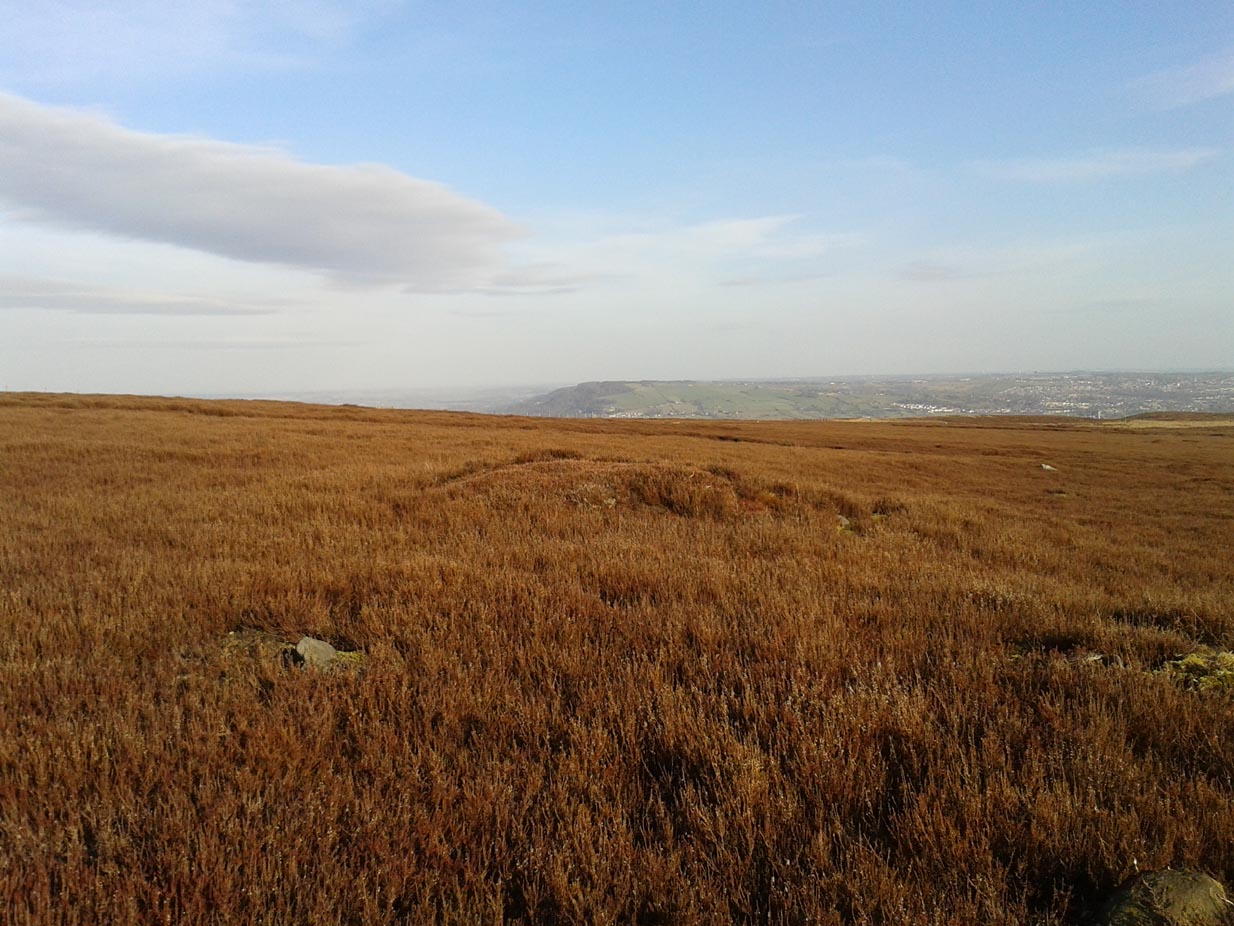
Take the same directions as if you’re visiting the Great Skirtful of Stones giant cairn on the boundary of Burley and Hawksworth. Cross the wire fence on its southern-side and, cross the (usually overgrown) prehistoric trackway 50-60 yards away. Keep in the same direction onto the pathless moor for about the same distance again, zigzagging back and forth, keeping your eyes peeled for some small overgrown rocky rises. You’ll find ’em.
Archaeology & History
Not to be confused with the much larger Bronze Age graveyard further south on the same moorland, this little-known prehistoric cemetery has had little of any worth written about it since the 19th century and—like many sites on these moors—has received no modern archaeological attention.
Close-up of one of the cairnsTwo of the cairns, looking NW
On my last visit to this site with James Elkington in 2015, only four of the heather-clad cairns were visible; but if you explore here after the heather has been burned away, a half-dozen such tombs are found in relatively close attendance to each other. They are each about the same size, being roughly circular and measuring between 3-4 yards across, 10-12 yards in circumference and a yard high at the most. As you can see in the attached images, they are quiet visible even when the heather has grown on them.
Another cairn in this group
This small cairnfield may stretch across and link up with the secondary cairnfield a half-mile to the southwest. More survey work is required up here.
As with the circle of Roms Law and the Great Skirtful of Stones, this relatively small cluster of cairns seems to have had a prehistoric trackway approaching it, running roughly east-west. A short distance west are the much-denuded waters of the Skirtful Spring.
References:
Bennett, Paul, The Old Stones of Elmet, Capall Bann: Milverton 2001.
Faull, M.L. & Moorhouse, S.A. (eds.), West Yorkshire: An Archaeological Guide to AD 1500 (4 volumes), WYMCC: Wakefield 1981.
Wardell, James, Historical Notes of Ilkley, Rombald’s Moor, Baildon Common, and other Matters of the British and Roman Periods, Joseph Dodgson: Leeds 1869. (2nd edition 1881).
Acknowledgements: Huge thanks to James Elkington for use of his photo in this site profile.