St. Maughold’s Well, Ramsey, Isle of Man

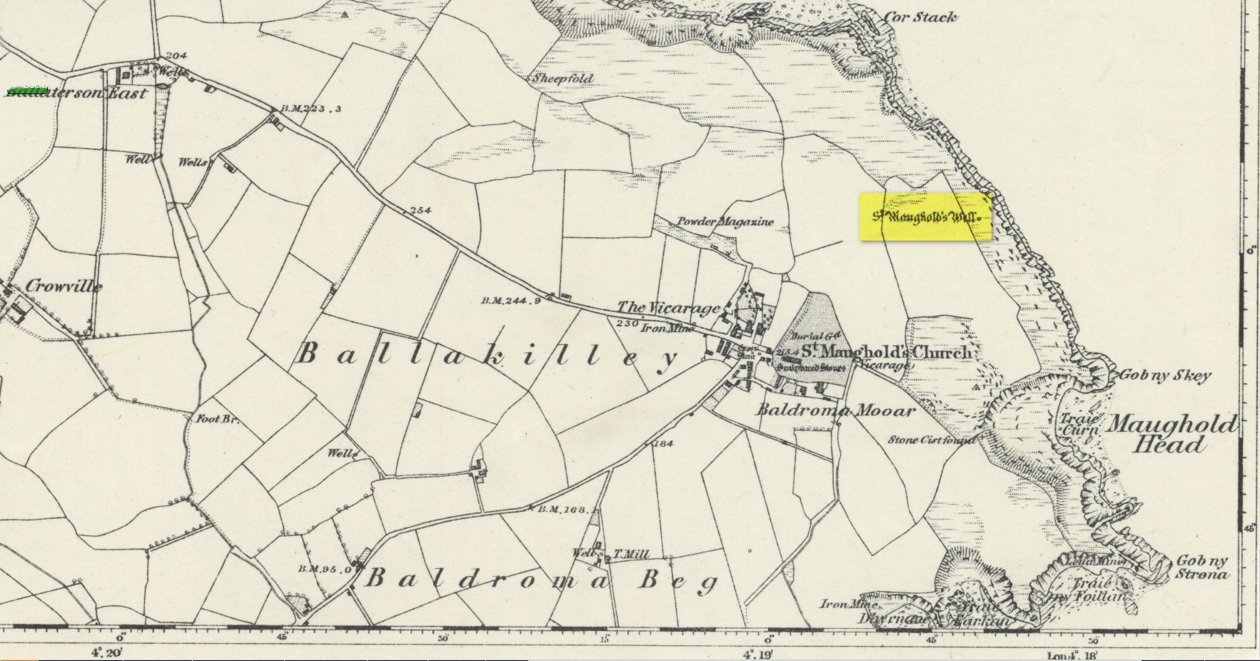
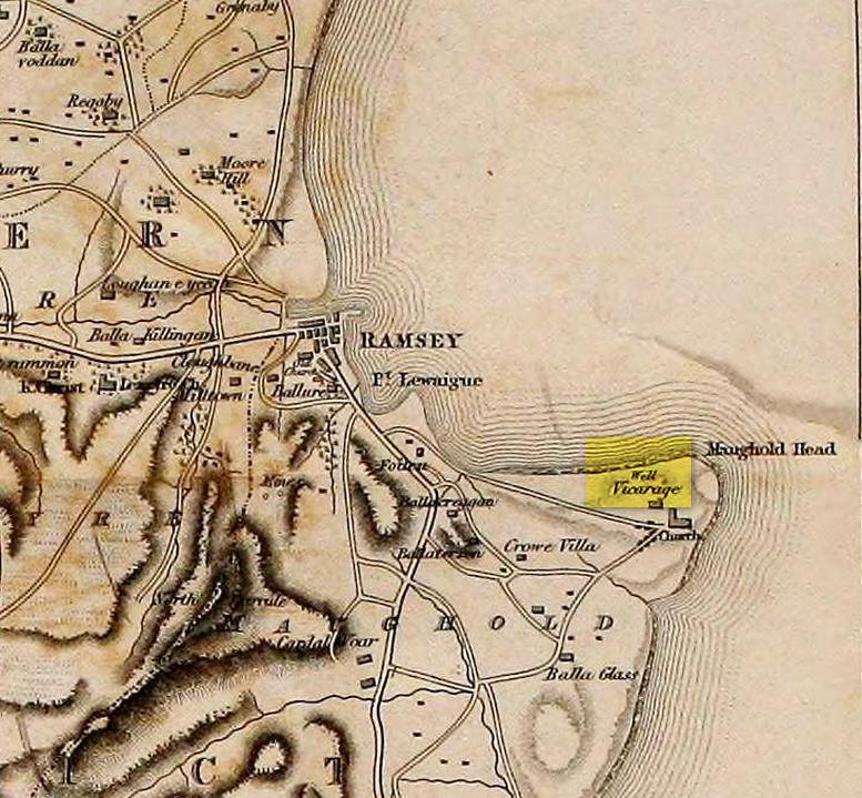
Holy Well:  OS Grid Reference – SC 49624 91926

Also Known as:

  1. Chibber Maghal
  2. Chibbyr Vaghal
  3. Chibbyr y Vashtee

Archaeology & History

St. Maughold’s Well—also called Chibbyr Vaghal—is found on the northeast side of the headland on the cliff face about a hundred feet above the sea, a quarter mile from the St. Maughold’s church.  It was a pilgrimage site which people visited on the dates of November 15 and July 31.

“…Beneath the head, under some moss clad rocks, is a deep spring, formerly much celebrated for its supposed medicinal virtues.”
– George Jefferson, 1840

St Maughold’s on 1870 map
‘Well’ on the 1836 map

Its medicinal properties are of great repute and was resorted to by many on account of its sanctity by crowds of pilgrims.  The well was traditionally visited on the first Sunday in August, being the first Sunday after the Saint ‘s principal feast day, July 31 (significant in the Celtic calendar), but the devotions here have their origins in pre-christian times.  The principal benefit at the well was a cure for sore eyes.  After bathing the eyes or drinking the water it was/is customary to drop a coin, pin or button into it.  Alternatively, a piece of cloth which had been used for bathing the eyes would be left by the well or on a nearby bush.  As the cloth rotted, the ailment would be cured; while anyone who picked up the rags would himself receive the complaint associated with the offering; and to receive the full benefit of the well’s curative powers it should be visited on that first Sunday in August, and “while books were open in the church” — or in pre-reformation days, whilst Mass was being offered.

“…Where the spring gushes forth the rock has been hollowed into a small basin, and over it has been erected a simple shed of rough unhewn blocks of the rock immediately at hand. Hither the Saint is said to have resorted; nor is it altogether improbable that nearly fourteen hundred years ago at this very font he administered the baptismal rite. Certainly it was for many ages in great repute for its medicinal properties, and was resorted to on account of its sanctity by crowds of pilgrims from all parts. Nor is it yet forgotten.”
– J.G. Cumming, 1848

“…A drink of its water, taken after resting in the saint’s chair close by, is supposed to be an unfailing cure for barrenness in women.”
– A.W. Moore, 1890

Folklore

At Maughold churchyard above the well, ghostly whispers are said to be heard by the steps in the churchyard.  This is interesting as when excavations were done here, the labourers found bones buried beneath the same steps.  They were dug and exposed during the day and one worker who stayed in the church heard distant sounds, whispers and murmuring all around the church.  When the bones were reinterred, the haunting stopped. (Bord & Bord 1985)

References:

  1. Bord, Janet & Colin, Sacred Waters: Holy Wells and Water Lore in Britain and Ireland, Granada: London 1985.
  2. Cumming, J.G., The Isle of Man: Its History, Physical and Ecclesiastical, J. van Voorst: London 1848.
  3. Hall, John, “Earth Mysteries of the Isle of Man,” in Earth, no.17, 1990.
  4. Moore, A.W., The Surnames and Place-Names of the Isle of Man, Elliot Stock: London 1890.
  5. Jefferson, George, Jefferson’s Isle of Man, G. Jefferson: Douglas 1840.
  6. Radcliffe, William & Constance, A History of Kirk Maughold, Manx Museum: Douglas 1979.

© John Hall, 1990

Acknowledgements:  Huge thanks for use of the Ordnance Survey map in this site profile, reproduced with the kind permission of the National Library of Scotland

Mercat Cross, Doune, Perthshire

Cross:  OS Grid Reference – NN 72704 01570

Also Known as:

  1. Market Cross

Getting Here

Easy to find: get into the middle of the village where the shops are in the main street and where another road veers off, the cross sits there in the middle in the traffic island.  The photo here shows its location clearly.

Archaeology & History

Doune’s Mercat Cross

Found at the meeting of the roads in the centre of this old lovely village, the Mercat Cross in its present state was, according to Act of Parliament, erected a few years prior to 1696.  Set on a square base of six steps in traditional pyramidal fashion, near the top of the 12-foot tall shaft  are carvings on the sides of the stone.  On the east-face was carved the Moray arms, and on the west face were carved sundials.  John Small (1900) told how the top of the cross is crowned by the figure of a lion, “holding in its paws a circular shield or escutcheon, surrounded by a ribbon enclosing he Moray crest, and bearing the motto, ‘Salus per Christum.’

John Small’s 1900 sketch

It has been damaged a few times over the years.  Sometime around 1800, Moray Mackay (1953) told that “the lion fell of and was damaged”, but was repaired shortly afterwards by a local man.  He also told, with considerable indignation, how the local authorities were responsible for damaging what used to be “four short pillars which stood at the corners of the base,” when they were “smashed off and removed , impairing the balance of the whole (cross) for the sake of six inches more traffic room”!  There are two such short pillars at the edges, but these aren’t the original stones.  There used to be a water pump in front of the cross, but this was removed many years ago.

References:

  1. Mackay, Moray S., Doune – Historical Notes, Forth Naturalist: Stirling 1984.
  2. McKenzie, A.F. & S., Doune – Postcards from the Past, Forth Naturalist: Stirling 1988.
  3. Small, John W., Scottish Market Crosses, Eneas Mackay: Stirling 1900.

© Paul BennettThe Northern Antiquarian 

Cow Clout Stone, Parton, Kirkcudbrightshire

Legendary Rock:  OS Grid Reference – NX 6694 7336

Also Known as:

  1. Cowcloot Stone

Getting here

Harper’s 1876 sketch of the Cow Clout Stone

OK—I’m cheating here, as I’ve not visited this site (bad of me!).  The directions given here are from Harper’s 1876 Rambles in this area.  He told that the stone “stands about 100 yards to the north of the march dyke betwixt Upper Ervie, now Ken-Ervie and Nether Ervie. There is little to indicate its whereabouts, but the visitor coming from Kenmure Bridge, and leaving the road on the left, opposite Ringour and Bennan farms, on the opposite side of Loch Ken, would come upon it without much trouble by following the march dyke half a mile up.”  Basically, along the A713 just over 2 miles north of the bridge at Parton (½ mile before reaching the Galloway Activity Centre), 60 yards from the “Farm Access No Parking” spot, in the trees a long straight line of walling runs uphill.  That’d be my route—straight up!

Archaeology & History

This is a curious entry that I’ve added without visiting the site; but as I might never get to see it I thought it should be displayed in the hope that others might check it out.  The earliest literary reference to it is from Crosbie’s (1845) entry in the New Statistical Account, where he implies that the markings on the stone are not of Nature’s handiwork.  In Malcolm Harper’s (1876) fine work exploring the history and folklore of this region, he gave us the first illustration of the stone, which looks suspiciously like elements that we find on cup-and-ring stones.  Many years later when the Royal Commission (1914) lads followed up on Crosbie’s entry, they thought the markings were probably Nature’s handiwork.  They told that:

“It is an irregular mass of outcropping rock about 3 feet in diameter, and bears on its surface certain depressed markings supposed to represent a cow’s foot, a horse-shoe, and impressions which might be made by a man’s foot and knee in the act of kneeling. The markings appear to be natural.”

But it’s the animistic elements and traditions here which are important and which gave the stone its very name…

Folklore

When Rev. W.G. Crosbie (1845) first wrote about this stone, he was narrating the tale told of it by local people, whose traditions were greatly neglected by the majority of writers at that time.  Such stories should be preserved at all times, as they tell us more about the psychocosms of pre-industrial cultures.  Here,

“On the farm of Arvie, there is a flat stone about three feet in diameter, on which are the marks of what might be supposed a cow’s foot, a horse shoe, the four nails on each side being very distinct, and the impression which might be made by a man’s foot and knee while he was in the act of kneeling, the knot of the garter being quite evident.  The tradition connected with this remarkable stone, commonly called the ‘Cow Clout,’ is, that the proprietor, in order to get up arrears of rent, “drave the pun,” or in other words, carried off the hypothecated stock, while a fierce resistance was made by the people, and that over this stone, on which a man had just been praying for relief against his enemies, the cattle passed followed by an officer on horseback, and that it remains as a memorial to posterity of the cruel deed.”

If someone in that neck o’ the woods can find out if the stone’s still there and perhaps send us a photo, or stick it on our Facebook group, that’d be great! 🙂

References:

  1. Coles, Fred, “The Recent Cup and Ring Mark Discoveries in Kirkcudbrightshire”, in Proceedings Dumfriesshire & Galloway Natural History and Antiquarian Society, volume 5, 1888.
  2. Crosbie, W.G., “Parish of Parton,” in New Statistical Account of Scotland – volume 4, William Blackwood: Edinburgh 1845.
  3. Harper, Malcolm M., Rambles in Galloway, Edmonston & Douglas: Edinburgh 1876.
  4. Royal Commission Ancient & Historical Monuments & Constructions of Scotland, Inventory of Monuments and Constructions in Galloway – volume 2: County of the Stewatry of Kirkcudbrightshire , HMSO: Edinburgh 1914.

© Paul BennettThe Northern Antiquarian

Mineral Well, Hickling, Nottinghamshire

Healing Well (lost):  OS Grid Reference – SK 692 293

Archaeology & History

At the rear east-side of st. Luke’s church in what was once the old stable yard at the back of the rectory, a large pond can be seen.  In the 19th Century it was much smaller than it’s present size—and in the centuries before that, it took the simple form of a clear spring of water, known by local folk simply as the Mineral Spring.  The medicinal properties of the waters seem to have been forgotten…

References:

  1. Wadkin, H.M., Hickling: Reflections of Yesteryear, Sherwood Free Press 1991.

© Paul BennettThe Northern Antiquarian

Abbey Cross, Whitby, North Yorkshire

Cross:  OS Grid Reference – NZ 90242 11300

Getting Here

Pretty easy to find: from Whitby town centre, head uphill to the great ruins of Whitby Abbey.  You go past Caedmon’s Cross and past the more recent church and graveyard to the car-park at the top, outside the abbey.  At the edge of the car-park on the grass, you’ll see this tall hard upright, nice and erect!

Archaeology & History

Cross shown on 1894 map

Highlighted on the earliest OS-maps and not to be confused with the nearby and more modern Caedmon’s Cross, this tall large monolith stands upon a stepped plinth comprising of six steps (originally five), about 18 feet high.  The top of the cross was knocked off a century or two ago, when it was reported to have been twenty feet!  Initially it stood about fifty yards closer to the Abbey, but was removed to its present position following the Dissolution. 

The brief history regarding its origin was described in George Young’s (1817) major work, in which he told that in 1474, on John Nightingale, rector of Sneaton parish, in his will “appointed his burial to be on the north side (of the Abbey), before the cross,” which was already standing at that time.  Young wrote:

“By this it would appear that the ancient cross, now standing in the abbey plain was then within the cemetery of the abbey.”

Abbey Cross, c.1900
Young’s 1817 sketch

This has subsequently been taken as the standard regarding its origin.  Tradition also told that it was an old market cross, but this was treated with considerable scepticism by George Young, who believed that the monks here simply wouldn’t have allowed such a thing at the edge the abbey and burial ground.  He found evidence to indicate that it “was at the port or harbour of Whitby that corn was bought or sold, that here were kept the standard bushels for measuring corn, and that here the market-clerk had his station.”  In spite of this, T.H. Woodwark (1934) reported that fairs had been held at the cross early in the 20th century.  In a thoroughly profane way, electrical wiring was wrapped around the bottom of the cross and led to a generator, along with washing-lines running from it to a caravan!  Mr Young would have been apoplectic!  

References:

  1. Atkinson, J.C., Memorials of Old Whitby, MacMillan: London 1894.
  2. Holt, Robert B., Whitby, Past and Present, Copas: London 1890.
  3. Woodwark. T.H., The Crosses on the North York Moors, Whitby Literary & Philosophical Society 1934.
  4. Young, George, A History of Whitby and Streonshalh Abbey (2 volumes), Clark & Medd: Whitby 1817.

Acknowledgements:  Massive thanks to Lindsay (wherefore art thou…?) Mitchell for getting us up here…  Huge thanks for use of the Ordnance Survey map in this site profile, reproduced with the kind permission of the National Library of Scotland

© Paul BennettThe Northern Antiquarian

Holy Well, Basford, Nottingham, Nottinghamshire

Holy Well (lost):  OS Grid Reference – SK 553 427

Archaeology & History

First mentioned in place-name records from 1409, this seemingly lost sacred well could be found in the south-side of St. Leodegarius’s churchyard.  It was filled-in sometime in the 19th century when the ground around it collapsed to some considerable depth, so the hole was covered.  Despite this, water kept re-appearing on and off over the decades and, in Bob Morrell’s (1988) holy wells survey, he told that following constant heavy rains in 1987, it was filled in for the last time.

References:

  1. Bailey, Thomas, Annals of Nottinghamshire, Simpkin Marshall: London 1853.
  2. Gover, J.E.B., Mawer, Allen & Stenton, F.M., The Place-Names of Nottinghamshire, Cambridge University Press 1940.
  3. Harte, Jeremy, English Holy Wells – 3 volumes, Heart of Albion press: Wymeswold 2008.
  4. Morrell, Robert, Nottinghamshire Holy Wells and Springs, Nottingham 1988.

© Paul BennettThe Northern Antiquarian

Robin Hood’s Well, Erdington, Warwickshire

Sacred Well (lost):  OS Grid Reference – SP 13 92

Archaeology & History

Robin Hood wells are numerous in Yorkshire and Derbyshire, but finding them in this neck o’ the woods is unusual (a Robin Hood’s Farm can be found nearly 14 miles south).  The waters here would have had obvious importance for local peasant folk in bygone centuries, perhaps with scatterings of Beltane and Midsummer rites hereby; but it seems that records are silent on such matters.  The only reference I can find of this place is in Bracken’s (1860) fascinating work on Sutton Coldfield, where he told that,

“At the extremity of the parish, near Pype, a little field is still called the Bowbearer’s Croft.  Tradition says two officers of the chase, bowbearers, had a lodge there; and that their duty was to guide the travellers across the wild country.  A very old cottage, that had been well built, was removed from the croft in 1828.  In that neighbourhood was a fountain, called Robin Hood’s well, now enclosed within the grounds of Penns, where the natural beauties of the situation have been judiciously displayed and improved by the taste of the late proprietor, Joseph Webster.”

Marshy ground to the east of Pype Hall fed the large pond, which is one contender for the site of this lost well.  What has become of it?  A search in the local library archives for any old manorial maps, or the field-name maps showing Bowbearer’s would prove truly helpful in relocating this site.

References:

  1. Bracken, L., History of the Forest and Chase of Sutton Coldfield, Simpkin Marshall: London 1860.

© Paul BennettThe Northern Antiquarian

Druid’s Well, Sutton Coldfield, Warwickshire

Sacred Well:  OS Grid Reference – SP 10162 97991

Also Known as:

  1. St. Mary’s Well

Archaeology & History

Druid’s Well in 1910(-ish)

Highlighted on the 1884 Ordnance Survey map of the region and located beyond the far eastern end of Braceridge Lake, this legendary well has seen better days.  A small well-house once covered the spring, but all we have left today is little more than a rectangular stone-lined concrete hole-in-the-ground where the waters collect (hopefully some local folk can bring it back to life).  But in the 19th century it was well known, much frequented and maintained.

Not much seems to be known about its mythic history, as the traditions surrounding its dual pagan-christian dedication seem to have been forgotten.  When the local writer Tom Burgess (1893) came to explore its history, he merely wrote:

“How it came to be called the Druids’ Well is not known, it is scarcely necessary to say that it can have no Druidical connection; it is very probable, however, that it was dedicated to Saint Mary long before the dam of Bracebridge Pool was made by Ralph Bracebridge in the reign of Henry V.”

Druids Well in 1917

Druid’s Well in 1932

Jeremy Harte (2008) suggested that this well’s druidic association may have come from a local man, William Hutton who, in the middle of the 18th century, “speculated on a druid sanctuary near Sutton Coldfield.”  But before Hutton, the 17th century Staffordshire topographer, Robert Plot, suggested that an arch-druid held residence on Barr Beacon, which is less than three miles west of here.  This idea was echoed by Midgley (1904) who told that Barr Beacon “is supposed to have been a Druidical shrine.”  Just over three miles to the northwest, the Druid’s Heath (a place-name derived, apparently, from an old family) at Aldridge also had its own array of folklore which, perhaps, may have had something to do with this well’s association.  When Roy Palmer (1976) wrote about the Druid’s Well in his folklore survey, he told that Sutton Coldfield,

“is said once to have been the seat of the arch-druid of Britain; perhaps this was his well, which was later christianized.”

So much to choose from…

References:

  1. Bord, Janet, Holy Wells in Britain – A Guide, HOAP: Wymeswold 2008.
  2. Bracken, L., History of the Forest and Chase of Sutton Coldfield, Simpkin Marshall: London 1860.
  3. Burgess, J.T., Historic Warwickshire, Simpkin Marshall: Lond 1893.
  4. Harte, Jeremy, English Holy Wells – volume 2, Heart of Albion press: Wymeswold 2008.
  5. Midgley, W., A Short History of the Town and Chase of Suton Coldfield, Midland Counties Herald: Birmingham 1904.
  6. Palmer, Roy, The Folklore of Warwickshire, Batsford: London 1976.

Acknowledgements:  Huge thanks for use of the Ordnance Survey map in this site profile, reproduced with the kind permission of the National Library of Scotland

© Paul BennettThe Northern Antiquarian

Holy Well, Blaston, Leicestershire

Holy Well (destroyed):  OS Grid Reference – SP 8234 9542

Also Known as:

  1. Our Lady’s Well

Archaeology & History

Site shown on 1885 map

There seems to be very little known about this site.  It was located in fields just above the site of the Augustinian Priory of St Mary, founded in 1220 CE, where now is Priory Farm, but there seems to be no trace left of it.  The great Leicestershire antiquarian John Nichols said the well had been dedicated to Our Lady, the Virgin Mary. This was echoed in John Curtis’ (1831) survey, who told that, “where the Priory formerly stood, a Dwelling House has been erected; and near it is a Well called Our Lady’s Well.” He told that it was deep and “walled below the surface.”

References:

  1. Curtis, John, A Topographical History of the County of Leicester, W. Hextall: Ashby-de-la-Zouch 1831.
  2. Rattue, James, ‘An Inventory of Ancient, Holy and Healing Wells in Leicestershire’, in Transactions Leicestershire Archaeological & Historical Society, volume 67, 1993.
  3. Trubshaw, Bob, Leicestershire and Rutland’s Holy Wells, Heart of Albion: Nottingham 2024.

Acknowledgements:  Huge thanks for use of the Ordnance Survey map in this site profile, reproduced with the kind permission of the National Library of Scotland

© Paul BennettThe Northern Antiquarian

Cross Oak, Berkhamsted, Hertfordshire

Sacred Tree:  OS Grid Reference – SP 964 079

Archaeology & History

Location of the Cross Oak, shown on 1883 OS-map

About mile south of Northchurch, on the far side of the A41 dual carriageway, somewhere past the old crossroads (or perhaps even at the crossing) an ancient tree lived—and truly lived in the minds of local people, for perhaps a thousand years or so.  Mentioned in the Lay Subsidy Rolls in 1307, the Cross Oak gave its name to the old building that once stood in the trees and the hill itself, at the place now known as Oak Corner.  Whether or not a “cross” of any form was set up by this old oak, records are silent on the matter.  Its heathen ways however, were pretty renowned! (a plaque should be mounted here)

Folklore

The first reference I’ve found of this place is in William Black’s (1883) folklore survey where he told that “certain oak trees at Berkhampstead, in Hertfordshire, were long famous for the cure of ague”—ague being an intense fever or even malaria. But a few years later when the local historian Henry Nash (1890) wrote about this place, he told that there was only one tree that was renowned for such curative traditions, that being the Cross Oak.  He gave us the longest account of the place, coming from the old tongues who knew of it when they were young—and it had it’s very own ritual which, if abided by, would cure a person of their malady.  “The legend ran thus”, wrote Mr Nash:

“Any one suffering from this disease was to proceed, with the assistance of a friend, to the old oak tree, known as Cross Oak, then to bore a small hole in the said tree, gather up a lock of the patient’s hair and make it fast in the hole with a peg, the patient then to tear himself from the tree, leaving the lock behind, and the disease was to disappear.

“This process was found to be rather a trying one for a weak patient, and by some authority unknown the practice was considerably modified. It was found to be equally efficacious to remove a lock of hair by gentle means, and convey it to the tree and peg it in securely, and with the necessary amount of faith the result was generally satisfactory. This is no mere fiction, as the old tree with its innumerable peg-holes was able to testify. This celebrated tree, like many other celebrities, has vanished, and another occupies its place, but whether it possesses the same healing virtues as its predecessor is doubtful.  It is however a curious coincidence, that the bane and the antidote have passed away together.”

The lore of this magickal tree even found its way into one of J.G. Frazer’s (1933) volumes of The Golden Bough, where he told how the “transference of the malady to the tree was simple but painful.”

Traditions such as this are found in many aboriginal cultures from different parts of the world, where the spirit of the tree (or stone, or well…) will take on the illness of the person for an offering from the afflicted person: basic sympathetic magick, as it’s known.  Our Earth is alive!

References:

  1. Black, William G., Folk Medicine, Folk-lore Society: London 1883.
  2. Frazer, James G., The Scapegoat, MacMillan: London 1933.
  3. Jones-Baker, Doris, The Folklore of Hertfordshire, B.T. Batsford: London 1977.
  4. Nash, Henry, Reminiscences of Berkhamsted, W. Cooper & Nephews: Berkhamsted 1890.

Acknowledgements:  Huge thanks for use of the Ordnance Survey map in this site profile, reproduced with the kind permission of the National Library of Scotland

© Paul BennettThe Northern Antiquarian