Take the same directions as if you’re going to visit the large Black Park (1) cairn, and from here look down the slight boggy slope to your right (east) and, across the other side of a small burn (stream) you’ll see a slightly raised grassy knoll. A curved dyke is to its left (west) side. You’re there!
Archaeology & History
This small cairn, barely two feet high at the most, and five yards across, is deemed as a possible Bronze Age cairn on Canmore and in the Royal Commission (1994) report of the area. There is certainly a pile of small stones here, but it may be a clearance cairn (I hope I’m wrong). Only an excavation will tell us for sure.
References:
Royal Commission Ancient & Historical Monuments, Scotland, Braes of Doune: An Archaeological Survey, RCAHMS: Edinburgh 1994.
Less than a mile east of Callander on the main A84 road, nearly 300 yards past the entrance to the Keltie Bridge caravan park, take the tiny road on your left (north) and barely 100 yards along turn right and go up here for excatly 1 mile (give or take a few yeards) where track goes into the forest on your left and you can park-up here. Walk up the track into the silence for just under a mile where, as the track splits and you kink to the right, a gate appears. On the other side of the gate, turn immediately left, almost walking back on yourself, just above the curving waters of a burn, through boggy reeds, keeping to the fence-line until, less than 300 yards along, you’ll reach what you’re looking for.
Archaeology & History
Black Park (1), looking W
This reasonably large cairn and its neighbours (Black Park [2], [3], [4] and [5]) would appear to be relatively new discoveries as I can find nothing about it prior to the Royal Commission’s 1994 survey. They are even absent from Moray MacKay’s (1953) excellent work on the area! Hence, descriptions of it are scant and visitors to the place are few indeed (we did meet a local who knew about the old tomb, but said that nothing was known about it); but it is, nonetheless, a fine, albeit denuded and very overgrown cairn, living today amidst a quiet mass of reeds and surrounded by boggy ground—so make sure you’ve got your boots on!
Internal line of stoneworkBlack Park (1), looking SE
At its height, today, it stands less than four feet tall and measures roughly 16 yards across at its widest. Through one section of the tomb there runs a raised line of stonework that almost looks like internal walling, which may have been where a chamber once existed. It’s been hollowed out by someone in the not-too-distant past but, as I said, there are no records of such a thing, so whether or not that was a chamber or merely a fortuituous collapse of stone in a straight line, we can’t really say. Along its more northern edges there seems to be a small raised wall of stone defining its edge, although once again it requires a more discerning examination to work out whether this is part of its original facade, or is a result of some of the stone mass falling to the edges.
Visit the old place and sit with its silence for a while…
References:
Royal Commission Ancient & Historical Monuments, Scotland, Braes of Doune: An Archaeological Survey, RCAHMS: Edinburgh 1994.
Stone Circle (destroyed): OS Grid Reference – NY 549 182
Archaeology & History
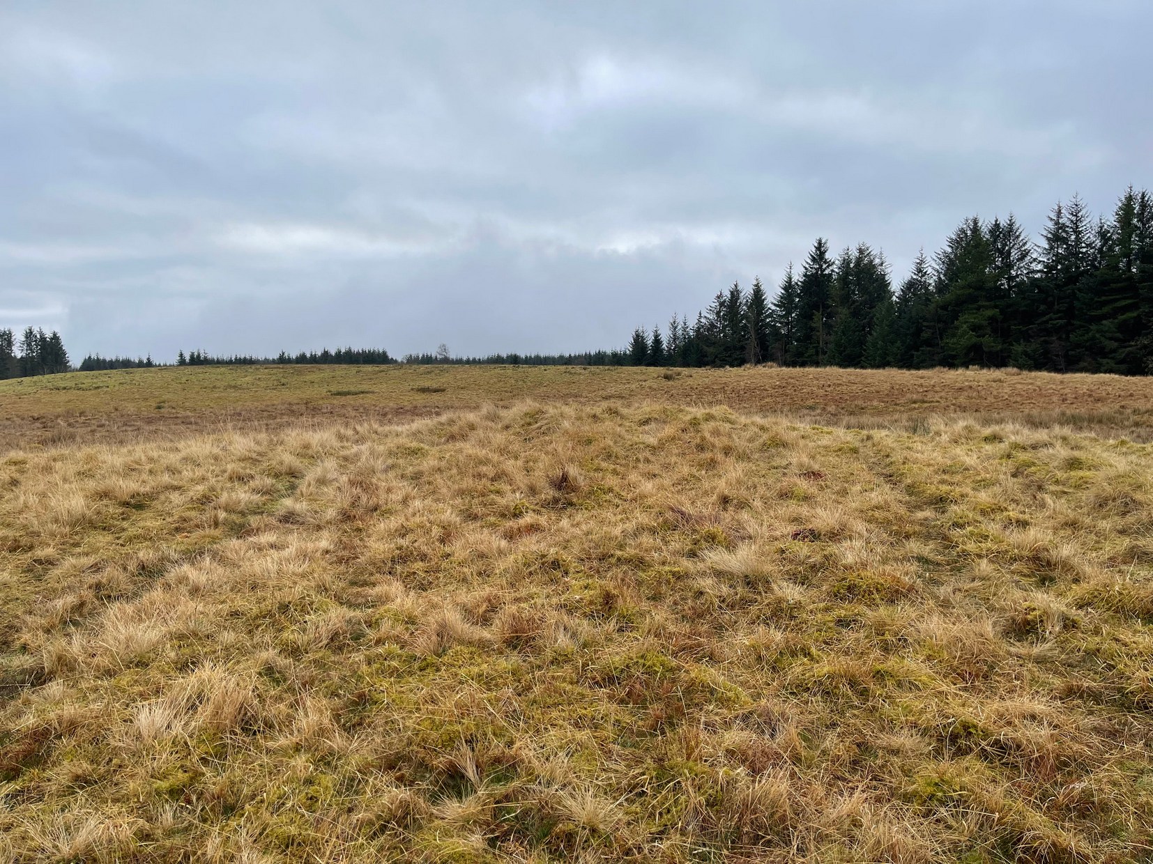
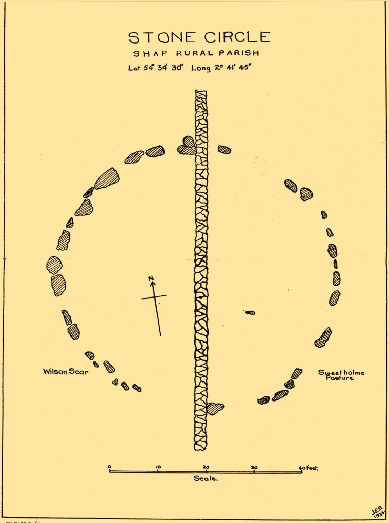
This site has been completely destroyed by the huge eyesore of a quarry that we all see when we’re travelling up the M6 north, above Shap. John Waterhouse (1985) told that “a rescue excavation” was carried out here with help from the kids at Penrith Queen Elizabeth School, shortly before its destruction in 1952, but now there is no trace left of it. When it was first described by J.E. Spence (1935), the circle had already been damaged by a wall that cut right through its centre. He told:
Spence’s 1935 plan
“The circle, which is 6o feet in diameter, is composed of 35 stones, 20 being on the west and 15 on the east side of the boundary wall running through the circle from north to south. The stones of which the circle is composed are Borrowdale erratics, a large number of which are scattered over the adjoining ground on both sides of the wall but more thickly in Sweet Holme Pasture. The stones, which vary up to 5 feet 9 inches by 3 feet, are larger and more numerous in the north-west quadrant where the tallest stands 1 foot 8 inches above the level of the turf. The ground within the circle is level, but to the south and west it slopes gently down from the edge of the circle in such a manner as to suggest that the area within the circle has been levelled.”
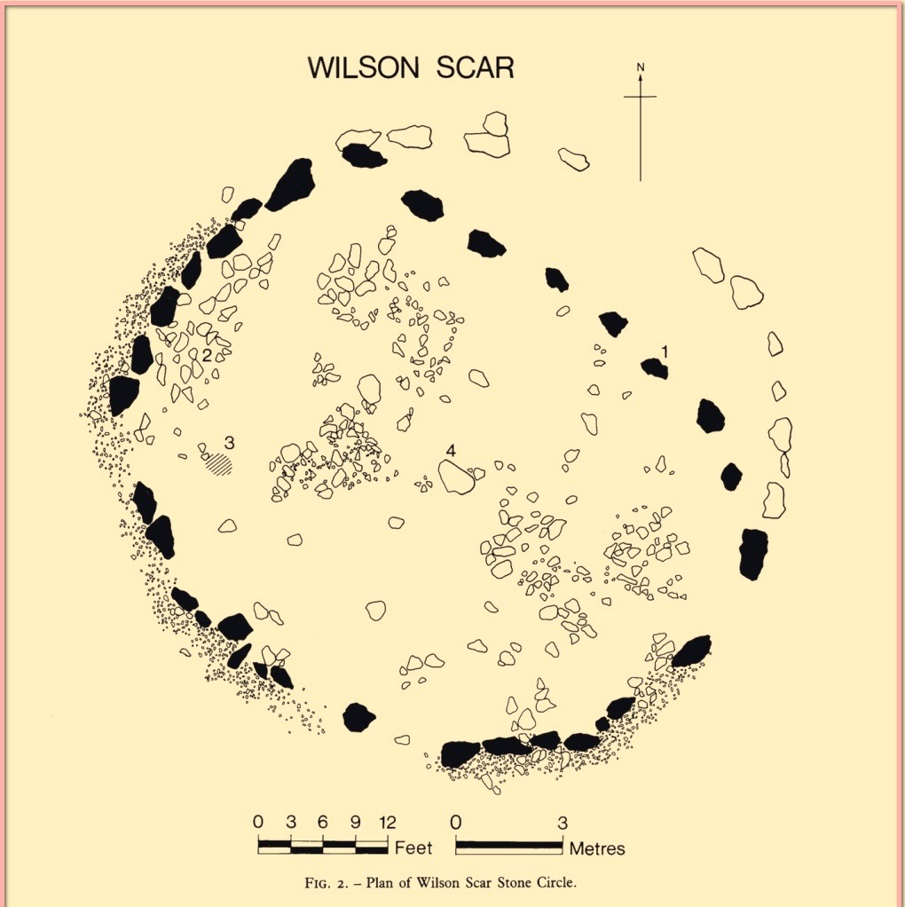
1952 plan laid over Spence’s 1935 plan
Spence told that an ancient “sunken trackway” led outwards from the circle to the south-west in the direction of Rosgill, but when the 1952 excavation occurred, no remains of such a track were found; nor was the wall that had cut through it; and the north-easterly section of the circle had been cut into and re-laid, presumably by the quarrymen. It was quite plain, wrote G.G. Sieveking (1984), “that this portion of the monument was encroached upon in the summer of 1952, and hastily reconstructed for the benefit of the archaeologists.”
Their excavation found that some internal sections of this ring had been paved with thin limestone slabs and they also uncovered two small cairns, neither of which possessed anything. However, they did find four funerary deposits within the monument: one at the northeastern section of the circle (no.1); another near the centre (no.4); and remains of a cremation west of centre (no.3); but the most complete find was at the western side of the ring, where a “disarticulated inhumation burial was lying immediately beneath the turf line in a shallow grave 1.35 m long, surrounded by a setting of small boulders.” It was a near complete human skeleton. This place was obviously, at times, used in ceremonies for the dead.
Shortly after the archaeological examination of the site, it was blasted away by quarrying. Gone!
References:
Barnatt, John, Stone Circles of Britain– volume 2, BAR: Oxford 1989.
Burl, Aubrey, The Stone Circles of Britain, Ireland and Brittany, Yale University Press 2000.
Farrah, Robert W.E., A Guide to the Stone Circles of Cumbria, Hayloft: Kirkby Stephen 2008.
Seton, Ray, The Reason for the Stone Circles in Cumbria, privately published: Morecambe 1995
Sieveking, G.G., “Excavation of a Stone Circle at Wilson Scar, Shap North 1952,” in Transactions Cumberland & Westmorland Antiquarian & Archaeological Society, volume 84, 1984.
Spence, J.E., “A Stone Circle in Shap Rural Parish,” in Transactions Cumberland & Westmorland Antiquarian & Archaeological Society, volume 35, 1935.
Waterhouse, John, The Stone Circles of Cumbria, Phillimore: Chichester 1985.
Cup-and-Ring Stone (lost): OS Grid Reference – Q 53 03?
Archaeology & History
Gowlane East (3) stone (Graves 1877)
First discovered by Richard Hitchcock in 1848, this petroglyph (along with the Gowlane East (2) carving) was one of two missing stones in the area that James Graves (1877) thought were seemingly “fragments of a large monument,” although he said nothing more about it and, sadly, Mr Hitchcock’s sketch here is all that we have left to guide us. The carving may have come from one of the nearby raths, souterrains, or have been part of a circle or cairn. The stone looks to have been reasonably small in size and, hopefully, is residing in a wall somewhere or is just buried in a field.
There are several Gowlane place-names in the area, but Judith Cuppage (1986) told that the great 19th century artist and antiquarian George du Noyer “identified the townland as Gowlane East”, although the closest “neighbouring townland” would be Gowlin (Gualainn). If any local folk know where this might be hiding, please let us know. (the grid reference cited here is a very vague guess!)
References:
Cuppage, Judith, Archaeological Survey of the Dingle Peninsula, Oidhreacht Chorca Dhuibhne: Ballyferriter 1986.
Graves, James, “On Cup and Circle Sculptures as Occurring in Ireland,” in Journal Royal Society Antiquaries, Ireland, volume 4 (4th series), April 1877.
Acknowledgements:Huge thanks for use of the Ordnance Survey map in this site profile, reproduced with the kind permission of the National Library of Scotland.
Cup-and-Ring Stone (lost): OS Grid Reference – Q 53 03?
Archaeology & History
Gowlane (2) carving (in Graves 1877)
When James Graves (1877) described the gorgeous Aghacarrible petroglyph, he told that “in the neighbouring townland of Gowlane” were three other carvings—with this fine multi-ringed design being one of them. It was first discovered and drawn by Richard Hitchcock in 1848 and was thought by Graves to have been broken from “a larger monument.” (like the Gowlane East [3] carving) Whether it was from a cairn, a souterrain or a stone circle, we can but guess. And we must also guess as to where it might be now, for no account of it has appeared since Mr Graves’ description. With any luck it will be in a wall somewhere, or simply buried in a field.
There are several Gowlane place-names in the area, but Judith Cuppage (1986) told that the great 19th century artist and antiquarian George du Noyer “identified the townland as Gowlane East”, although the closest “neighbouring townland” would be Gowlin (Gualainn). If any local folk know where this might be hiding, please let us know. (the grid reference cited here is a very vague guess!)
References:
Cuppage, Judith, Archaeological Survey of the Dingle Peninsula, Oidhreacht Chorca Dhuibhne: Ballyferriter 1986.
Graves, James, “On Cup and Circle Sculptures as Occurring in Ireland,” in Journal Royal Society Antiquaries, Ireland, volume 4 (4th series), April 1877.
Cup-and-Ring Stone (removed): OS Grid Reference – NT 12364 32627
Also Known as:
Drumelzier Carving
Archaeology & History
Position of stone in cairn
A carving that was located at the edge of a cairn on a knoll on the east-side of the River Tweed, this is an odd design that now lives in Edinburgh’s central museum: odd, inasmuch as the design looks as if it’s a typical cup-and-ring carving, yet none of the cups on this stone were ever hollowed or pecked out, and so the “cups”, so to speak, are actually small rings (if that makes sense!). There are a number of similar unhollowed “cups” on other carvings that are found associated with prehistoric tombs, so perhaps this aspect was something of a burial trend—amongst a very small tribal group, perhaps… It’s an element that was remarked upon in Simpson & Thawley’s (1972) examination of petroglyphs in neolithic tombs that were called “passage grave style” carvings: a sort of dyslexic cup-and-ring design no less! The intriguing thing about this carving is that it’s one in a small cluster of dyslexic cup-and-rings that are found in this part of Scotland—in an area where rock art itself is pretty scarce. Which begs the question: was it a local tribal style? Anyhow…
The carving was first uncovered when J.H. Craw (1930) excavated the aforementioned cairn, finding therein a number of cists. There’s speculation that the petroglyph might originally have been a covering stone for one of the cists, but we don’t know for sure. Craw described the carving as follows:
Craw’s 1930 sketchRon Morris’ 1981 sketch
“The ring-marked slab…measures 3 feet by 2 feet by 6 inches. It lay at the north side of the cairn (highlighted in sketch, PB), outside the encircling ring, but may originally have been the cover of cist No.2. On the upper side are five shallow ring-markings, four being double and one single. The former measure 3 inches to 4 inches in diameter, and the latter 1¾ inch. The figures are thus much smaller than in typical cup-and-ring-marked stones, and the lines are only ¼ inch in width. The only similar markings known to me are on a slab which I found a number of years ago near the site of several former cairns, and forts at Harelawside near Grant’s House, Berwickshire. The stone is now in our Museum.”
The “museum” in question being Edinburgh’s National Museum (I don’t know if it’s in a box somewhere or on public display, which is where it needs to be). If anyone can get a good photo of this carving, please send it to us or add it on on our Facebook group.
Morris, Ronald W.B., “The Cup-and-Ring and Similar Early Sculptures of Scotland; Part 2 – The Rest of Scotland except Kintyre,” in Transactions of the Ancient Monuments Society, volume 16, 1969.
Morris, Ronald W.B., The Prehistoric Rock Art of Southern Scotland, BAR: Oxford 1981.
Ritchie, Graham & Anna, Edinburgh and South-East Scotland, Heinnemann: London 1972.
Royal Commission on the Ancient & Historical Monuments, Scotland, Peeblesshire – volume 1, Aberdeen University Press 1967.
Simpson, D.D.A. & Thawley, J.E., “Single Grave Art in Britain,” in Scottish Archaeological Forum, no.4, 1972.
Acknowledgements:Huge thanks for use of the Ordnance Survey map in this site profile, reproduced with the kind permission of the National Library of Scotland.
A little-known multiple ringed carving was discovered a few years ago during the excavation of a prehistoric cairn just immediately east of the A701 roadside, several miles south of Broughton. The cairn itself had been recognised many years prior to the recent excavation, when one of two cists inside it was noted by R.B.K. Stevenson (1940), and which was subsequently described in slightly more detail in the Royal Commission Inventory (1967). But when the modern investigation was undertaken by the Biggar Archaeology Group in 2008, a damaged but impressive carving was uncovered that somehow hadn’t been noticed before. It was described in Tam Ward’s (2008) excavation report where he told that,
Carving in situ (photo courtesy Jim Ness)Carving looking N: courtesy Jim Ness
“lying almost immediately on the east side of Cist 1 is an angular rock…measuring 1m long and over 0.3m wide on the uppermost face, itself lying at an angle facing SW and away from the cist. The rock has fractured due to weathering in post deposition times, as indeed several other surface stones had, but on the widest part of the upper surface are at least seven concentric lines faintly pecked into the smooth flat surface of the stone. The lines are up to 10mm wide and appear to have been intended to form semi ovals on the edge of the rock. The outer ring forms an arc of c270mm on the long axis by c140mm on the short one (the former measurement being straight between the ends of the lines and the latter being a radius across the design). The terminals of the inner curved line are about 80mm apart. The lines are slightly irregular in distance from one another. Although it is far from certain, it does not appear that the rock has been part of a larger one with a more complete design on it, rather the pecking appears not to have been finished since the surface of the rock is similar in appearance overall while the abrasion of the carving varies.”
Fractured design (photo courtesy Jim Ness)
The carving remains in place with the cist, which was covered back over when the excavation had been finished.
Carvings such as this are uncommon in this neck o’ the woods; although less than a mile downstream from here, on the other side of the river, another petroglyph—known as the Drumelzier carving—accompanied another prehistoric tomb. Apart from this, there’s a great scarcity of carvings scattering the Lowlands—although it’s likely that there are others hiding away, waiting to be found on these hills…
References:
Royal Commission on the Ancient & Historical Monuments, Scotland, Peeblesshire – volume 1, Aberdeen University Press 1967.
Stevenson, R.B.K., “Cists near Tweedsmuir,” in Proceedings Society Antiquaries, Scotland, volume 74, 1940.
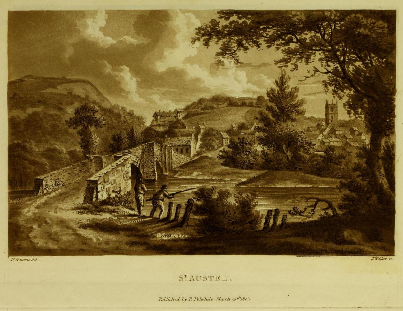
Tumulus (destroyed): OS Grid Reference – SX 0309 5227
Archaeology & History
More than two hundred years ago, an impressive prehistoric burial mound lived in an area that used to be known as Gwallon Down, not far from the impressive Long Stone monolith, about half-a-mile west of Charlestown on the southern edges of St. Austell, but it was completely destroyed in 1801. Thankfully there was a lengthy account made of the site in John Whitaker’s (1804) huge work, but there seems to be little else known of it. He told us:
“In the middle of that extended waste, the downs of St. Austle, was, what was called One Barrow. This waste, in 1801, was resolved to be enclosed, and the barrow was obliged to be levelled. In this operation, the single workman came near the centre, and there found a variety of stones, all slates, ranged erect in an enclosure nearly square. The stones were about one foot-and-a-half in height, apparently fixed in the ground before the formation of the barrow. The stones were all undressed, but had little stones carefully placed in the crevices at the joints of the large, in order to preclude all communication between the rubbish without and the contents within. On the even heads of these stones was laid a square freestone, which had evidently been hewn into this form, which seemed to rest with its extremities on the edges of the others, and was about eighteen or twenty inches in diameter. The summit of the barrow rose about eight or ten feet above all. In the enclosure, the leveller found a dust, remarkably fine, and seemingly inclining to clay. On the surface it was brown, about the middle downwards it took a dark chestnut colour, and at the bottom it approached towards a black. On stirring it up, a multitude of bones appeared, different in the sizes, but none exceeding six or seven inches in length. Among them were some pieces about the largeness of a half-crown, which, from their concave form, convinced him they were parts of a skull. The whole mass of bones and ashes might (he thought) be about one gallon in quantity. On touching the bones, they instantly crumbled into dust, and took the same colour with the same fineness as the dust in which they were found. They were exceedingly white when they were first discovered, but remarkably brittle; the effect assuredly of their calcination in a fire, antecedent to their burial. Much in fineness and in colour with these ashes, appeared several veins of irregular earth on the outside of the enclosure; which, from their position without, yet adjoining, and from the space occupied by them there, he conjectured to have been bodies laid promiscuously upon the funeral pile, but which I conjecture to have been only the ashes adhering to the ground, and not possible to be separated from it, for a burial with the rest within the enclosure. They had nothing of sand in them, but seemed inclining to clay, and even more so (from the adhering soil probably) than the dust of the enclosure. And, as the workman was fully convinced of what every one else must acknowledge, that the ashes and the bones of the enclosure had once belonged to a human body, he very properly took up the whole with care, placed the stones nearly in their original posture within an hedge contiguous, then in building, placed also the bones with the ashes within their original enclosure there, and even placed the covering-stone over both.”
One wonders where precisely the hedgerow happened to be where the stones were placed “nearly in their original posture”, and if this reconstruction was ever recovered.
The site was subsequently mentioned in Polwhele’s (1816) massive survey, reiterating Whitaker’s description, simply telling how:
“With respect to the monumental remains in the neighbourhood of St Austel, a very ingenious correspondent says in one of the mounds of earth on our downs which was lately levelled a kind of urn was discovered which evidently contained human ashes many of the bones were entire but appear to have been calcined I am well acquainted with the man who dug this up.”
References:
Borlase, William Copeland, Nænia Cornubiæ, Longmans Green Reader: Truro 1872.
Hammond, Joseph, A Cornish Parish: Being an Account of St. Austell, Skeffington & Sons: London 1897.
Polwhele, Richard, The History of Cornwall – volume 2, Law & Whittaker: Truro 1816.
Whitaker, John, The Ancient Cathedral of Cornwall – volume 2, John Stockdale: London 1804.
Make a day out for this one! You could, of course, go barely half-a-mile straight up the hill (southwest) from Ossian’s Stone in the Sma’ Glen below – but it’s steep as fuck and I know that most of you wouldn’t do it. So, park-up and take the gradual 3 mile walk into the mountains. Coming via Crieff, along the A85 road east, turn left up the A822 Dunkeld road at Gilmerton. 2½ miles on, you reach the Foulford golf course on the right-hand side of the road, whilst directly across the road a dirt-track leads you into the fields, past the large Foulford cup-and-ring stone. Keep along this track, bearing right just before Connochan Lodge and follow this dirt-track uphill on and on for another 2 miles where you’ll eventually see the cairn-peak in the distance. Another shallow track leads uphill after about 2 miles: we walked up to where the ground levels out, walked across the dodgy swamp-land and up again to the tomb. It’s well worth it!
Archaeology & History
Visible for many miles round here from the surrounding hills, this somewhat mutilated giant cairn, highlighted on the earliest Ordnance Survey map of the area in 1867, hasn’t fared well in archaeology tomes. Apart from a passing note in Margaret Stewart’s (1966) summary article on prehistoric remains in central Perthshire—where she erroneously told it to be 400 feet lower down that it actually is—almost nothing has been said of this place. Most odd.
Cairn spoil, looking SENew cairn atop of the old
Despite it being ransacked over the centuries, it was obviously of some considerable size in its early days. Today, surmounting it, is a very large walker’s cairn which, no doubt, has accrued some of its own foundations from the prehistoric tomb on which it sits. To the side of this recent cairn, another one is growing, thanks to stones brought from near and not-too-far. But the original creation can still be seen in outline and mass all around. Indeed, as you walk all round the modern cairn, you’re walking over much of the early collapsed stonework sleeping gently beneath the moorland vegetation, and once you walk away and below the cairn mass itself, looking back up at it you’ll notice the very ancient raised plinth of stone on which our modern one now lives.
Low walling on NW side
Its amorphous shape is somewhat amoeboid, measuring more than 22 yards across east-west, by 15 yards north-south, with a curious arc of low walling, very old indeed, on its northwestern side. Whether this walling outlines the original edge of the tomb, only an excavation will tell. The most notable remaining mass of ancient cairn material reaches out on its south-east to eastern edges, where some of it is beginning to fall away down the edge of the mountain slope.
Folklore
Local tradition assigns this cairn to be where the bones of the great hero-figure Ossian was removed to, when they were disturbed by the unruly mob of General Wade and his cohorts in the middle of the 18th century. Notes of the event were written at the time by one of Wade’s mob, a Captain Edward Burt, who told,
“the Highlanders, they assembled from distant parts, and having formed themselves into a body, they carefully gathered up the relics, and marched with them, in solemn procession, to a new place of burial, and there discharged their fire-arms over the grave, as supposing the deceased had been a military officer.”
This was essential, said Burt, as
Site shown on 1867 mapNew cairn on old, looking W
“they (the Highlanders) firmly believe that if a dead body should be known to lie above ground, or be disinterred by malice, or the accidents of torrents of water, &c. and care was not immediately taken to perform to it the proper rites, then there would arise such storms and tempests as would destroy their corn, blow away their huts, and all sorts of other mis-fortunes would follow till that duty was performed. You may here recollect what I told you so long ago, of the great regard the Highlanders have for the remains of their dead…”
Oral tradition tells us that this cairn, high above Ossian’s Stone, is where the rites occurred. It makes sense too.
References:
Finlayson, Andrew, The Stones of Strathearn, One Tree Island: Comrie 2010.
Acknowledgements:Huge thanks for use of the Ordnance Survey map in this site profile, reproduced with the kind permission of the National Library of Scotland.
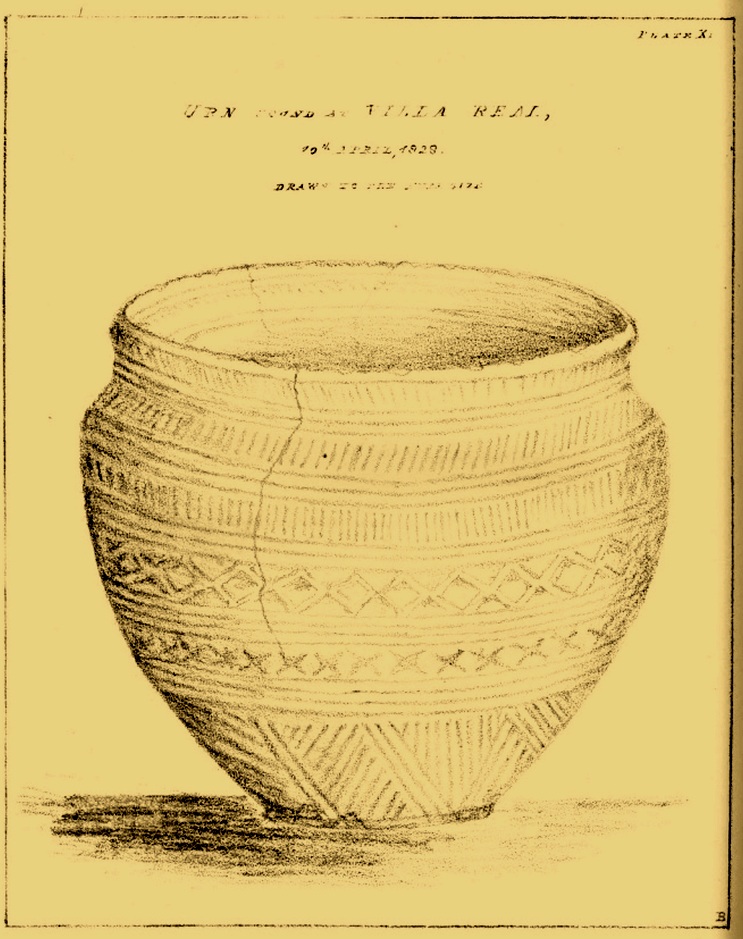
All remains of this prehistoric burial site have obviously long since fallen into only the vaguest of memory, but its incidence deserves reviving for those who may live nearby and seek for a place where our truly ancient ancestors once faired. Here, beneath the modern buildings of homo-profanus, less than a mile north-east of Newcastle city centre, a small prehistoric burial chamber, or cist, was uncovered quite accidentally by a Mr Russell Blackbird (1832) in the first-half of the 19th century. In a letter to the newly-formed (as it was back then) Society of Antiquaries of Newcastle in April of that year he told,
“In trenching some ground for planting, this morning, we discovered a stone vault, 4 feet long by 2 feet wide, and 20 inches deep, deposited in a dry hard marl below the soil, which we were taking out for making the walks in the garden. It contained the bones of a man, the head, in particular, quite perfect, with all the teeth in it. Also a small urn (was found)… There was some red-coloured earth in the urn which the labourers threw out.”
Mr Blackbird sent the antiquarian society a sketch of the urn that he and his colleagues discovered, reproduced here.
References:
Blackbird, Russell, “Account of the Discovery of a Stone Vault and Urn, at Villa Real, Jesmond,” in Archaeologia Aeliana, volume 2, 1832.
Acknowledgements:Huge thanks for use of the Ordnance Survey map in this site profile, reproduced with the kind permission of the National Library of Scotland.