From Ilkley, take the Wells Road heading towards White Wells, bending round the bottom of the moor, making sure you keep left along Westwood Drive (not further up the moor along the Keighley Road). Keep along Westwood Drive – it becomes Panorama Drive after a while – until you come to the small copse of woods on your right, a short distance before the end of the road. Go along the footpath by the wall at the side of the house, bending into the woods after 10 yards. Another 10 yards on, you’re near the edge a drop down the slope, where a number of large rocks are seen. Look around!
Archaeology & History
Carving 236 (after Boughey & Vickerman)
A singular cup-and-ring carving can be seen, rather faintly, near the nose-end of this large mossy stone, close to the edge of the ridge. It is one of a small cluster of carvings that remain in this small bit of woodland. Other highly ornate carvings could once be seen in the same stretch of woodland — where the rich houses now stand — amidst remains of a prehistoric enclosure or settlement of some sort. All remains of this settlement have been destroyed, which is a pity as it may have given us helpful information about the nature of this carving and its nearby relatives.
References:
Bennett, Paul, The Panorama Stones, Ilkley, TNA: Yorkshire 2012.
Boughey, Keith & Vickerman, E.A., Prehistoric Rock Art of the West Riding, WYAS: Wakefield 2003.
Hedges, John (ed.), The Carved Rocks on Rombalds Moor, WYMCC: Wakefield 1986.
From the B6265 valley road between Bingley and Keighley, just near Riddlesden Hall, take the road up and over the canal into Riddlesden, bearing left up past West Riddlesden Hall and up Banks Lane. As you reach the T-junction at the top, where you hit the Silsden Road that goes round the moors, park up.Cross the road and follow the footpath diagonally across the bottom of the field, then when you hit the track, follow it up through the closed gates into the woods. A half-mile along the track, watch out for the dark pool a few yards beneath you on your left. That’s it!
Archaeology & History
The spirit and feel of this pool is a curious one: still, calming, but with a slight sense of unease at times. It felt like this before the large forestry plantation was planted around it — so it’s good to know it’s kept its spirit intact. I’m not quite sure how long it will last though… The small spring of water from just above the edge of the pool which in part feeds it, tastes good and refreshing after a good downpour, but sometimes in recent years the waters have slowed somewhat compared to earlier decades — an unhealthy state of affairs that’s happening all over the world.
A favourite haunt for very colourful dragonflies, deer, pheasant and other animals, very little has been written about this site. Said by place-name authorities to get its name from an old oak that once stood by its side, the name must be pretty old as no remains of such a tree has been mentioned by any antiquarians in the last 200 years. But the first element in the place-name “riv-ock” is an intriguing puzzle. Does it mean simply a split oak? Or was it a more regal in nature, and derive from the old Gaelic Righ, (proncounced ‘ree’) meaning a King’s Oak? More probably the name relates to the “well by the twisted oak,” from the dialect word, rive, or ‘twisted’. However, when we begin exploring dialect variations on this word, a whole host of possible meanings emerge!
Ancient people who lived on these moors obviously used this well — and no doubt had old tales of its medicinal virtues, but sadly these are lost. All we have to remind us that our ancestors came here are the numerous cup-and-ring stones found at Rivock Edge itself, a short distance southeast of here…
References:
Whelan, Edna & Taylor, Ian, Yorkshire Holy Wells and Sacred Springs, Northern Lights: Dunnington 1989.
From the B6265 valley road between Bingley and Keighley, just near Riddlesden Hall, take the road up and over the canal into Riddlesden, bearing left up past West Riddlesden Hall and up Banks Lane. As you reach the T-junction at the top, where you hit the Silsden Road that goes round the moors, park up. Takes the footpath across the road and walk straight uphill, all the way to the top just above where the tree line ends and you’re on the moorland flat. Bear right, over one wall, then walk 20-30 yards further and the stone in the photo here should be roughly under thine nostrils!
Archaeology & History
There’s no previous record of this as a cup-marked stone, so it needs adding here. I’ve gotta admit that I’m not 100% sure about it as a real prehistoric carving — but considering the dubious nature of the nearby Carving no.58 and the Rivock Nose Stone, this is roughly somewhere in-between in terms of its legitimacy as an ancient carved stone. Certainly I’ve come across other cup-markings, adjudged by newly-qualified ‘professionals’ as fine, but which I find highly questionable — so this one that Dave Hazell came across a couple of years ago should certainly be added to their professional rock art catalogues.
Close-up of the cupmarks
It’s simple enough: a four-feet long stone, whose top east-facing edge has been worked in more recent centuries by the miners who dug on the slopes below (perhaps to turn it into a gatepost?). There are three notable ‘cups’ that are clearly visible on the photos here. The topmost cup is something pretty recent, having had industrial attention given it; the largest cup may be natural; but the one in the middle seems to be what our English Heritage rock-art enthusiasts term a legitimate prehistoric petroglyph. It certainly seems a good one! Have a look for yourself and see what you reckon! It’s in a good spot and is certainly worth the wander, if only to have a look at other cup-and-rings in the region.
From the B6265 valley road between Bingley and Keighley, just near Riddlesden Hall, take the road up and over the canal into Riddlesden, bearing left up past West Riddlesden Hall and up Banks Lane. As you reach the T-junction at the top, where you hit the Silsden Road that goes round the moors, park up. Cross the road and follow the footpath up the field, but walk up the side of the field-wall where the woods are, all the way to the top. On the flat, you’ll see a gap in the woods on your left, and the triangulation pillar atop of Rivock Edge 150 yards away. Head towards it, watching out for one of the natural rocks rising near the middle of the grasses. It’s one of them!
Archaeology & History
Faint cup-and-ring, centre of photo
Exactly halfway between the cup-marked Niplet Stone and the large flat Carving 58 (Boughey & Vickerman survey) is this natural long upright rock, shaped in the form of a house-roof, with its apex running along an axis SE-NW, its sloping sides dropping either side into the deep wet heather. Upon its crown is what may be a singular cup-marking, almost perfectly formed, though is just as likely to be Nature’s handiwork as much as anything else. But on its western-face, within the mass of old lichen painting the rock surface, a more distinct man-made cup-mark has been cut.
On its eastern face, close to where the rock meets the boggy Earth, a singular faint cup-and-ring design can be made out, albeit a somewhat mis-shapen one. It’s easily missed if the lighting isn’t too good as it’s very eroded indeed. The carving was first described in Mr Hedges (1986) survey, where he told:
“Rough grit rock with ridge, in crowberry and heather with cup and ring on E edge and possible cups and grooves.”
The stone’s certainly worth visiting, as a number of other cup-and-ring stones scatter this region — half of them officially recorded, but nearly as many again that aren’t. It’s a good area to explore.
References:
Bennett, Paul, “The Prehistoric Rock Art and Megalithic Remains of Rivock & District (parts 1 & 2),” in Earth, 3-4, 1986.
Boughey, Keith & Vickerman, E.A., Prehistoric Rock Art of the West Riding, WYAS 2003.
Hedges, John (ed.), The Carved Rocks on Rombald’s Moor, WYMCC: Wakefield 1986.
Morris, Ronald W.B., “The Prehistoric Rock Art of Great Britain: A Survey of All Sites Bearing Motifs more Complex than Simple Cup-marks,” in Proceedings of the Prehistoric Society, volume 55, 1989.
Take the same directions as if you’re visiting the Rivock Edge 060 Carving. It’s 25 yards NNW – you can’t really miss it!
Archaeology & History
Rivock Edge, carving 58
This large flat rock, with a couple of long lines almost splitting the rock into sections, was first mentioned as a prehistoric site in John Hedges (1986) survey, where he described it simply as, “Large rough grit rock with possible four cups, in crowberry.” Boughey & Vickerman (2003) said even less about it! One of the cups is very distinct, but the others are somewhat faded and perhaps even dubious. It’s still worth a look at, if only due to the other better carvings nearby.
References:
Bennett, Paul, “The Prehistoric Rock Art and Megalithic Remains of Rivock & District (parts 1 & 2),” in Earth, 3-4, 1986.
Boughey, Keith & Vickerman, E.A., Prehistoric Rock Art of the West Riding, WYAS 2003.
Hedges, John (ed.), The Carved Rocks on Rombald’s Moor, WYMCC: Wakefield 1986.
From the famous Dick Hudson’s pub on the south side of Ilkley Moor, take the road right (east) for a half-mile until you reach the large Weecher Reservoir just off the roadside on your right. Less than 300 yards past the reservoir, a footpath takes you onto the moor itself. Walk up the path for about ⅔-mile — crossing one wall, then walking roughly parallel with another on your right — until you reach a crossing of paths where there are 2 gates or stiles. Take the lower of the two stiles, through the wall, but below the fence. You’ll see an awful Yorkshire Water cover, which has just about destroyed the once-fine well that had always flowed here. Below this, by the wallside, are the trickling remains of our old healing spring.
Archaeology & History
When I was a young boy, Horncliffe Well was the site we would visit every weekend as our first stopping-spot on our regular ventures exploring these moorlands — “from Wrose to Rombalds,” as we use to call it! The old well was always very plentiful, strong-flowing, cold and truly refreshing. It was undoubtedly the best water source on the entire Rombalds Moor region, never drying up. Even in the great droughts of 1976 and 1995, after all others had just about failed, the waters at Horncliffe were still flowing as strong as ever, as they had always done. But not anymore…
Edna Whelan’s old drawing
First described in land records of 1273 CE, this has always been a well of great repute and oral tradition told that this great old well never ran dry. It marked the ancient boundary point where the moorlands of Hawksworth, Burley and Bingley all meet. By name alone it is associated with the nearby and curious Horncliffe Circle, whose status itself is unclear (the circle seems more a place of refuge or living than a true ritual site).
Horncliffe House around 1801
The remains of old buildings on the flat just above where the waters once flowed were built in much more recent centuries. The building appears to have been started around 1799, for E.E. Dodds (1985) told that in 1800 it was used as a school for several years by local teacher Joshua Briggs. J. Horsfall Turner (1907) published a copy of an old drawing of the school, as it was soon after construction.
Horncliffe Well was dug into by the privatized water company known as Yorkshire Water (owned by rich greedy fuckers) in the 1990s, who channelled most of its endless supply away for commercial benefit. When their company was stealing the water from the moors, the workmen snapped an old markstone at its base next to the adjacent Horncliffe House (in ruins). The waters had always flowed fast and freely, but after Yorkshire Water had finished their ‘work’ here, the great majority of Horncliffe’s water supply subsided considerably, leaving walkers, birds and animals to suffer from its demise. In all sincerity, it’s to be hoped that good people someday will visit this once-fine site and return it to its previous healthy status.
Folklore
When we were kids we came here every weekend and got to know the old ranger who we’d meet either here or at the adjacent Horncliffe Circle, 250 yards NNE, where we’d sit and eat. In the mid-1970s, he told us that the old well was once a site where the fairy-folk would play, around Mayday (beltane). And though in later years I’ve sought for any information about this in all early antiquarian books that cover this area, I’ve never found any mention of this tale in print. The old ranger knew the moors and its history better than anyone I’ve ever known and many old stories died with him after his death.
References:
Bennett, Paul, The Old Stones of Elmet, Capall Bann: Chieveley 2003.
Dodd, E.E., Bingley: A Yorkshire Town through Nine Centuries, M.T.D. Rigg: Guiseley 1985.
Laurence, Alastair, A History of Menston and Hawksworth, Smith Settle: Otley 1991.
Turner, J. Horsfall, Idle Upper Chapel Burial Registers and Graveyard Inscriptions, Harrison & Son: Bingley 1907.
Whelan, Edna, The Magic and Mystery of Holy Wells, Capall Bann: Chieveley 2001.
Whelan, Edna & Taylor, Ian, Yorkshire Holy Wells and Sacred Springs, Northern Lights: Dunnington 1989.
Walk from Ilkley up the Wells Roads as if you’re going to the White Wells, but keep following the road along, keeping to the moorside (don’t go up Panorama Drive). A few hundred yards up, crossing the small bridge over the gorse-scattered stream, take the footpath to your right and walk along the moor-bottom, parallel to the rich houses. Keep walking, past the reservoir (don’t go up the slope on the newly created path) and cross the small wooden bridge. Once over the other side, head through the gate and walk along the rocky footpath into the woods. Less than 100 yards down where the first seat is, there’s a slow-running blood of water oozing out from the rocks.
Archaeology & History
At the top of this bit of old woodland, out of rocks near the top of the trees, emerges another of Yorkshire thousands of chalybeates, or iron-bearing springs of water, on the very edge of Ilkley Moor. Collyer and Turner (1885) mentioned its discovery in 1883, but gave no further details. Searching for this place on one of my countless moorland ambles as a child, I found its waters oozing slowly from betwixt moss-enriched rocks on the west side of the stream. If you look for it in the dry season though, there is little to see. It is best seen later in the year, after heavy rains, although the waters are pretty slow running and have that distinct “off” taste (an attribute well-known of chalybeates —taste ‘em and see!). The only real account of this little-known healing well was told in an early edition of the Leeds Mercury (1883), shortly after its rediscovery, in which we were told:
“Our Ilkley correspondent says the existence of a chalybeate spring has lately been discovered there, and from its valuable medicinal properties will prove a valuable adjunct in the future development of this health resort. The water from the spring (which is situated near to the Panorama Rocks, in what is known as Hebers Gill, or Briery Wood) has been submitted to Mr F.M. Rimmington…of Bradford for analysis and his report is of a most favourable character. The data shows that the water is remarkable for the smallness of the amount of its saline constituents, and (so far as the analyst has been able to discover by reference to published analysis of either English or Continental chalybeate springs), there is not one comparable to it: whilst its ferruginous element is equal to the majority of such waters and, in Mr Remmington’s opinion, as large as is desirable for medicinal effect. The spa that most resembles the one under notice is that of Tunbridge Wells in Kent, which is derived from exactly the same geological formation (millstone grit), the total solid constituents of this water being 13½ grains to the gallon. The report adds that, “The use of this class of waters as medical agents has, from remote periods, been found efficacious in those states of debility denominated anemia,” and “the value of this class of spa water as a safe and natural remedy can scarcely be overestimated.” From the foregoing it will be seen that an important discovery has been made…”
This once important spring of water — that would have been known and used by our prehistoric ancestors living on the moors above — is nowadays but a shadow of its former self. The water tables drop annually as a result of moorland drainage and other poor land management and we only see a small trickle of water emerging from the mossy rocks these days…
…to be continued…
References:
Anonymous, “Important Discovery at Ilkley,” in Leeds Mercury, August 18, 1883.
Bennett, Paul, Healing Wells and Springs of Ilkley Moor, unpublished: Hebden Bridge 1995.
Collyer, Robert & Turner, J.H., Ilkley: Ancient and Modern, William Walker: Otley 1885.
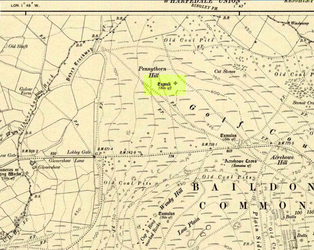
Highlighted on the 1909 OS-map of the area, on the top of the hill a short distance from the roadside, about 250 yards northwest of the Acrehowe Hill site (now at the edge of the golf course) could once be seen another prehistoric burial mound. The rediscovery of this tumulus was first announced briefly in the January 1905 edition of the Bradford Scientific Journal (issue no.3). A few months later the local writer and historian William Preston (1905) wrote a more detailed article on the site, telling the following information:
“A discovery of considerable interest to local archaeologists was made early in December, 1904, on the summit of the spur of moorland on the northwest of Baildon Moor, known as Pennythorn Hill.
“A workman engaged in removing stones from an extension of the golf course, unearthed an ancient cinerary urn containing calcined human bones, a flake of flint which may have served the purpose of an arrow point, a bronze instrument, and a perforated piece of bone, unfortunately broken during calcination. An examination of the site of the discovery revealed the remains of a tumulus, the upper part at some time removed, with a diameter as near as it was possible to tell, of about fifteen feet. In point of construction it differed little from others which are to be found in the locality. The vessel had been placed in an inverted position over the calcined bones, in a hole made in the sandy subsoil. There was no indication of the urn having rested in a cist.
“The earth beneath the urn bore no evidences of fire, and it is likely that the funeral pyre on which the corpse was reduced to ashes was not erected on the spot. It may be assumed from the association of the weapons named that the bones are those of a male person.
“The height of the urn is twelve and a half inches, it is eight and a quarter inches in diameter, and taper in the lowest third of its height to a base of about three inches in diameter. In the course of its excavation it was broken by the workmen, but it has been excellently restored in the laboratory of the Hull Museum…
“The urn belongs to the early British type and its date is, probably, well before the Roman invasion of the island. The general outline of the urn is very similar to that of some urns found by Canon Greenwell in the course of his exploration of the barrows of the north of England… The surface of the urn is divided into three zones. The upper part of the vessel consists of a raised border, about four inches wide, decorated with horizontal and vertical lines alternately arranged, and produced by pressing a twisted thong up0n the clay of which it was composed… Beneath the border and upon the central part of the body, a different form of decoration has been carried out. A zig-zag line scratched in the clay has been carried around the body, forming a number of triangular compartments, which were filled in with diagonal lines, giving he appearance of a herring-bone pattern. The counterpart this design does not appear on any of the urns figured by Canon Greenwell in his records of digging in British barrows.”
References:
Greenwell, William, British Barrows, Clarendon Press: Oxford 1877.
Preston, William E., “The Discovery of a Cinerary Urn on Baildon Moor,” in Bradford Scientific Journal, no.4, April 1905.
Wardell, James, Historical Notes of Ilkley, Rombald’s Moor, Baildon Common, and other Matters of the British and Roman Periods, Joseph Dodgson: Leeds 1869. (2nd edition 1881)
Follow the same directions to reach the superb Badger Stone carving, and from here take the footpath that runs downhill. You’ll cross another footpath about 100 yards down the moor, but just keep walking down the path and you’ll notice the small copse of woods ahead of you. As the footpath begins to swerve roughly away, northeast, heading away from the said woodland, keep your eyes peeled on your left for a reasonably large but flattish rock close to the ground (in summer it’s surrounded by bracken) about 75 yards away. That’s your target!
Archaeology & History
Of the hundreds of cup-and-ring stones on Ilkley Moor and district, this is one of my personal favourites! I first visited the stone in 1977 as a young teenager and was mightily impressed by the unusual nature of the design here — and that impression still remains. Aswell as possessing the usual cups and rings, the Barmishaw Stone is one of just a few rocks also possessing a sort of ‘ladder’ design or linear pattern within the overall carving: an insignia echoed on the nearby Willie Hall Wood carving, the Piper Stone, and also on the Panorama Stones. As with the ‘ladders’ on the Panorama carving, those found here at Barmishaw are very eroded and are increasingly difficult to see during the daytime (the best time to notice them is usually around sunrise or sunset, and particularly when the rock itself is wet).
The carving has been described many times, albeit briefly, by a number of writers. In John Hedges (1986) fine survey he said the following:
“Medium sized flat-topped rock…fairly smooth grit, sloping slightly east to west, covered with carvings, some of which are very worn. Slanting sunshine needed to detect them. About twenty-four cups, at least nine with rings or incomplete rings, two with multiple grooves half round and continuing straight down, one of them incorporating ‘ladder.’ Five other ‘ladders’ – in a good light. Cups mostly deep and clear.” A few years later, Boughey & Vickerman (2003) echoed much of Mr Hedges description, though noted that of the 24 cups with their rings, one possessed a triple ring.
Alan Davies’ illustration
Like so many cup-and-ring stones, they have given rise to hosts of fascinating theories and ideas — one of which is based on mathematics and metrology. In the 1980s, Alan Davies (1983, 1988) surveyed the Barmishaw Stone — and other carvings on Ilkley Moor — to explore the possibility that the cups and rings were laid out according to a basic unit of measure, the Megalithic Inch (MI), as proposed by Alexander Thom some years earlier. Although Davies’ work showed that such a primary unit of measure wasn’t to be found universally, his research at the Barmishaw Stone indicated “significant evidence for quanta of…3 MI,” although this occurred “when the analysis is restricted to only ringed cups.” Despite this, Davies thought that the existence of the Megalithic Inch was evident in this and other carvings on the moors, stating that:
“The repeated emergence of the significance of ringed cups, and the fact that all putative quanta seem to bear a simple numeric relation to each other do not seem to be coincidental.”
Although it has to be said that the selectivity of data in Davies’ research is more indicative that the Megalithic Inches in the the carvings was due, neither to chance nor mathematics, but more that the implements used to carve the rocks and the size of the hands of the people doing the carvings was pretty uniform and so, as a result, would give an obvious window of numeric similarities that can easily be mistaken as a deliberate metrology. These simplistic factors need assessing. In modern trials that we’ve done carving cup-markings, we’ve found them to be of similar size to those carved in prehistoric times—as you’d expect.
Barmishaw Stone (after Hedges, 1986)Barmishaw stone (Cowling 1946)
The ladder motif central to this carving may have related to early religious and ritual events here. Across the world, indigenous cultures commonly relate the ‘ladder’ to be a symbol of ascension, both by shamans, mystics and during rites of passage. The symbol represents the journey of the soul to and from supernatural realms. To discount this possibility at the Barmishaw Stone would be shortsighted.
The carving was very probably painted when our neolithic ancestors gathered here, much as Australian aborigines still do to their carvings using lichens and other plant dyes, with the respective ladders and lines changing colour where movements between worlds or shifts of attendant spirit occurred. By virtue of the its very name, I consider this rock to have been considerably important; the “ghost” aspect to barmishaw being a typically misconstrued aspect of ‘spirit’.
Folklore
This excellent cup-and-ring marked stone probably derives its name from the old dialect words “barm i’ t’ shaw”, meaning “ghost in the wood” stone. Whatever guise the attendant spirit of this rock may have had has long since been forgotten; though spectral accounts from the beginning of the nineteenth century until modern times may give us clues. There have been several reports of green-coloured elemental creatures around the area between here and the White Wells sacred spring a short distance to the east. The most recent account, from 1987, took on the modern mythic form of a little green man from space, with attendant UFO to boot! The Barmishaw Hole nearby was a place where faerie-folk used to live. Excesses of geological faulting and water makes the magickal nature of this place particularly potent.
References:
Allen, J. Romilly, “The Prehistoric Rock Sculptures of Ilkley,” in Journal of the British Archaeological Association, volume 35, 1879.
Allen, J. Romilly, “Notice of Sculptured Rocks near Ilkley,” in Journal of the British Archaeological Association, volume 38, 1882.
Bennett, Paul, “Cup-and-Ring Art”, in Towards 2012, volume 4, pp.83-92, 1998.
Bennett, Paul, The Old Stones of Elmet, Capall Bann: Milverton 2001.
Boughey, Keith & Vickerman, E.A., Prehistoric Rock Art of the West Riding, WYAS: Wakefield 2003.
Cowling, E.T., ‘A Classification of West Yorkshire Cup and Ring Stones,’ in Yorkshire Archaeological Journal 1940.
Cowling, E.T., Rombald’s Way: A Prehistory of Mid-Wharfedale, William Walker: Otley 1946.
Davis, Alan, ‘The Metrology of Cup & Ring Carvings near Ilkley in Yorkshire,’ Science Journal 25, 1983.
Davies, Alan, ‘The Metrology of Cup and Ring Carvings,’ in Ruggles, C., Records in Stone, Cambridge University Press 1988.
Eliade, Mircea, Patterns in Comparative Religion, Sheed & Ward: London 1958.
Hedges, John (ed.), The Carved Rocks on Rombalds Moor, WYMCC: Wakefield 1986.
Wright, Joseph, The English Dialect Dictionary – volume 1, Henry Frowde: Oxford 1905.
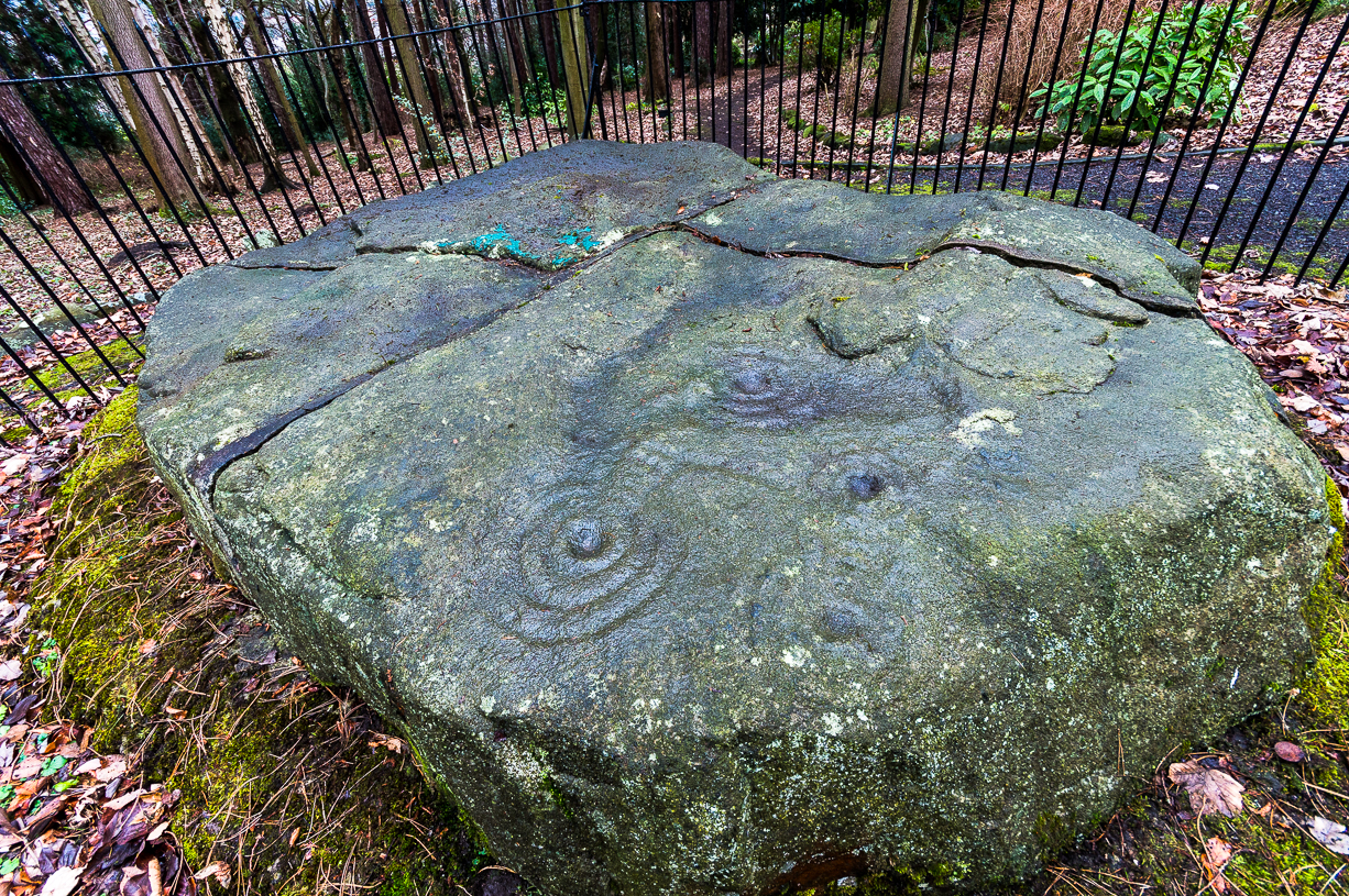
Come out of Ilkley/bus train station and turn right for less than 50 yards, turning left up towards White Wells. Go up here for less than 100 yards, taking your first right and walk up Queens Road until you reach the St. Margaret’s church on the left-hand side. On the other side of the road, aswell as a bench to sit on, a small enclosed bit with spiky railings all round houses our Panorama Stones.
Archaeology & History
J.R. Allen’s 1879 drawing
There were originally ten or eleven carvings that made up what have been called the Panorama Stones and the position they are presently housed in this awful fenced section wasn’t their original home. They used to live a half-mile further up from here, on the moorland edge, just in the woodland at the back of the small Intake Reservoir in the appropriately named Panorama Woods. But in 1890, one Dr. Little — medical officer at Ben Rhydding Hydro — bought the stones for £10 from the owner of the land at Panorama Rocks, as the area in which the stones lived was due to be vandalized and destroyed. Thankfully the said Dr Little was thoughtful and as a result of his payment he had some of the stones saved and moved into the position where they live today. However, as a result of the stones being transported closer to Ilkley, the largest of the carvings was damaged and broken in two pieces on its journey, but the good doctor and his mates restored the rock as best they could before sitting it down in the caged position where it remains to this day.
Thankfully there remain a couple of carved rocks in situ in the trees near where these companions originally came from — though they’re completely overgrown. We uncovered these carvings (one of which was quite ornate) when we were children, but this is now overgrown again and hidden from the eyes of the casual forager. The original position of these carvings was obviously an important feature to our ancestors, but such aspects are of little relevance to industrialists and those lacking sacred notions of the Earth. The same geological ridge on which the Panorama Stones were originally found, stretching west along the moor edge from here, possesses a number of other fascinating carvings, not least of which is our Swastika Stone.
J.T. Dale’s 1880-ish drawingT.Pawson’s late-1870s photo, showing faint ladder marks
It seems they were all first recorded by one J. Thornton Dale, who did some fine illustrations of each stone, which were then collected and organized by a certain Dr. Call of Ilkley in 1880 as a ‘Collection of fourteen drawings of cup-marked rocks.’ These were on file at Ilkley Library (or at least used to be!) and as they’ve not been published previously, I think they need to be retrieved from their dusty shelves and stuck on TNA where they certainly belong! As we can see in Dale’s illustration — etched shortly after the stone was first discovered — much of the detail of the multiple-rings and some of the curious ladder-like motifs were noted (though not all).
Around the same time in 1879, the renowned archaeologist J. Romilly Allen did an early article on the carved stones of Ilkley Moor, selecting the Panorama Stones as one site in his essay. He was very fortunate in getting an early look at the carvings here and gave the following lucid account:
“The Panorama Rock lies one mile south-west of Ilkley, and from a height of 800ft above the sea commands a magnificent view over Wharfedale and the surrounding country. About 100 yards to the west of this spot appears to be a kind of rough inclosure, formed of low walls of loose stones, and within it are three of the finest sculptured stones near Ilkley. They lie almost in a straight line east and west, the first stone being 5ft from the second, and the second 100ft from the third. The turf was stripped from the first a few years ago, and its having been covered up so long probably accounts for the sculpture being in such good preservation. It measures 10ft by 7ft, and is im- bedded so deeply in the ground that its upper horizontal surface scarcely rises above the level of the surrounding heath. The sculpture consists of twenty-five cups, eighteen of which are surrounded with concentric rings, varying from one to five in number. The most remarkable feature in the design is the very curious ladder-shaped arrangement of grooves by which the rings are intersected and joined together. I do not think that this peculiar type of carving occurs anywhere else besides near Ilkley. The second stone is of irregular shape, measuring 15ft by 12ft, and supporting a smaller stone of triangular shape 6ft long by 4ft broad. Both upper and under stone are covered with cups and rings, but the sculptures have suffered much from exposure. The superimposed block has eleven cups, two of which are surrounded by single rings. The under stone has forty-two cups, nine of which have rings. Amongst these are two unusually fine examples, one has an oval cup 5in by 4in, surrounded by two rings, the diameter of the outer ring being 1ft 3in. Another has a circular cup 3in diameter and five concentric rings, the outer ring being 1ft 5in across. The third and most westerly stone of the group measures 10ft by 9ft, and lies almost horizontally, having its face slightly inclined. On it are carved twenty-seven cups, fourteen of which have concentric rings round them. Some of the cups have connecting grooves and three have the ladder-shaped pattern before referred to. Several stones near have cup marks without rings.”
Heywood’s artistic effort!E.T. Cowling’s drawing
When Harry Speight (1900) visited these stones a few years later he echoed much that Romilly Allen had said previously, also commenting on how on certain parts of the carving, “the rings enclosing each cup are connected with ladder-like markings.” (my italics, PB) These “ladders” were even mentioned in a speculative but inaccurate essay by Nathan Heywood (1888) in a paper for the Lancashire and Cheshire Antiquarian Society. Equally important was a description of the site when members of the Yorkshire Archaeological Society visited the Panorama Stones in 1884, and Rev. A.C. Downer (1884) described this “most important group” of stones, saying that
“Near the Panorama Rock are three large masses of ironstone close together, and averaging ten to twelve feet across each way, the horizontal surface of which are covered with cups and rings, and two of these stones have also a peculiar arrangement of grooves somewhat resembling a ladder in form.”
Modern Folklore
Despite this and other descriptions, in recent times local archaeologist and rock art student Gavin Edwards has propounded the somewhat spurious notion that the ladders and perhaps other parts of the Panorama Stone carvings have a recent Victorian origin, executed by a local man by the name of Mr Ambrose Collins. Edwards took this silly idea to the Press, thinking he’d found something original, following a recovery of some notes from the Ilkley Gazette newspaper (earlier archaeologists had already explored this, which he should have been aware of), in which was stated that the said Mr Collins told other people in the Ilkley area that he was carving some of the old stones on the moors nearby. Now we know that Collins did this (we have at least 3 examples of his ‘rock art’ in our files), but he wasn’t allowed to touch the Panorama Stones!
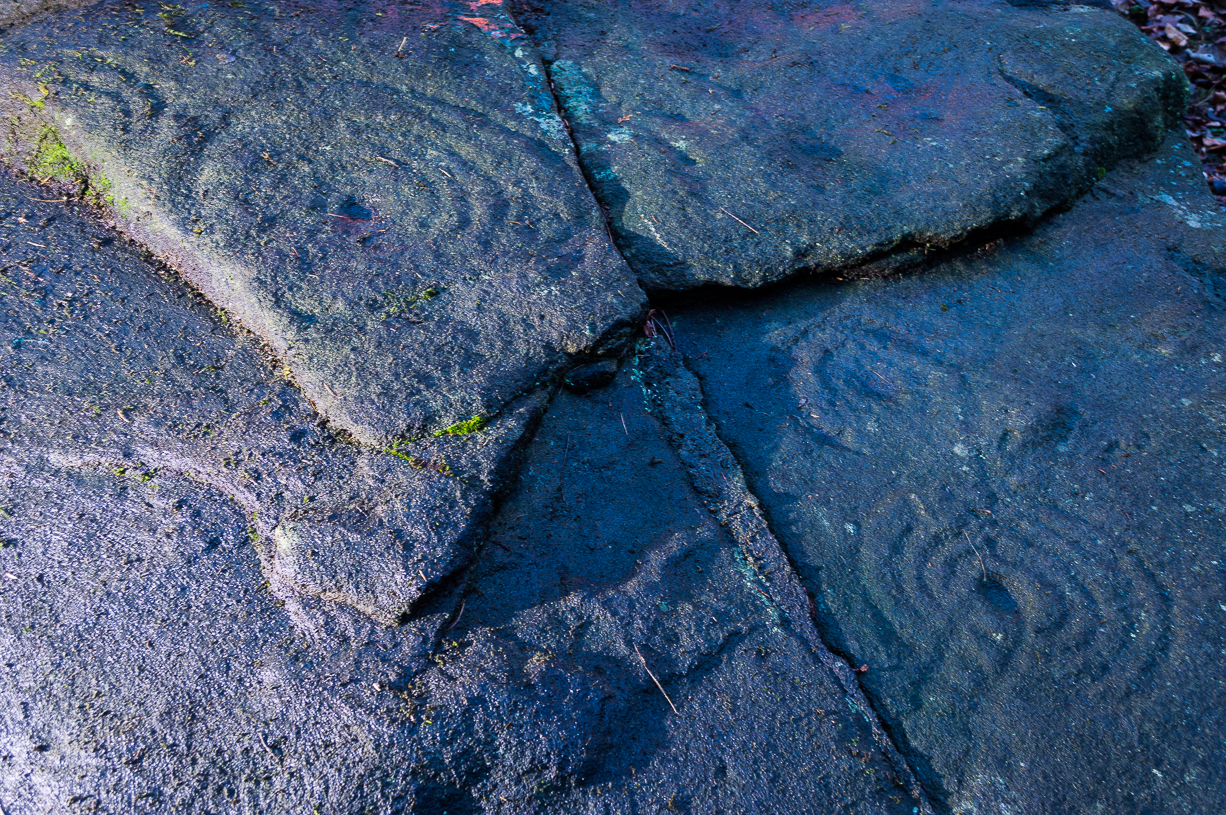
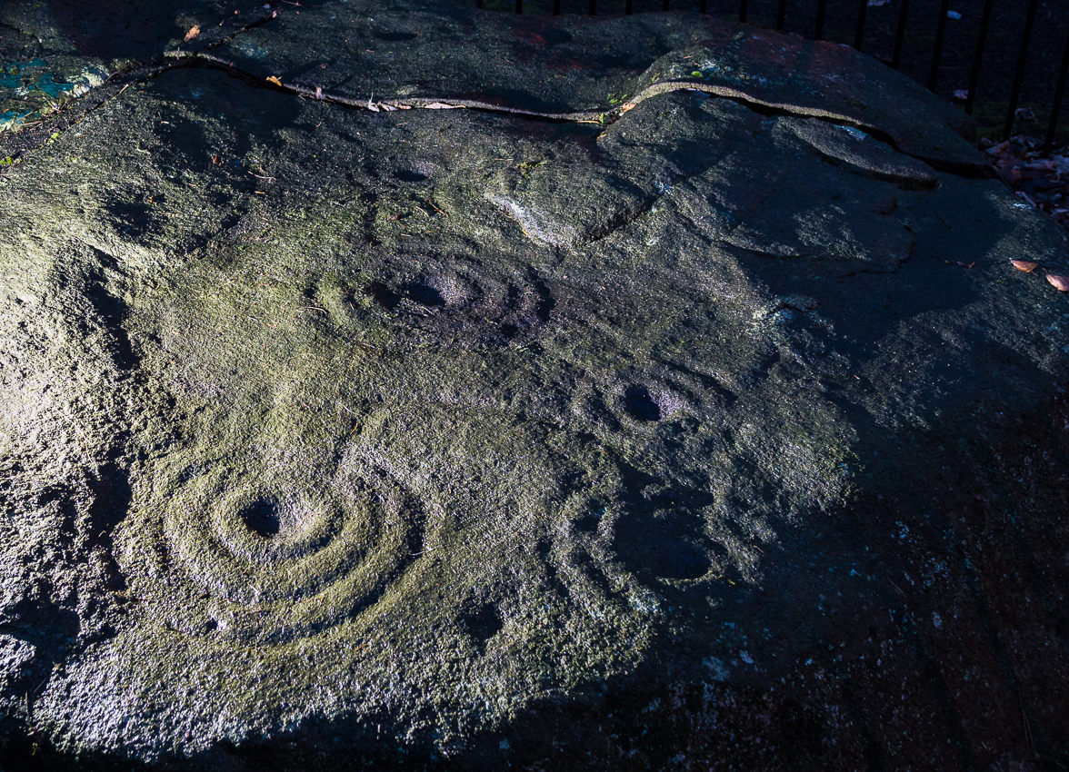
Panorama Stone 229 (by James Elkington)Close-up of multiple rings (by James Elkington)
However, despite Gavin Edwards’ theory, it is clear that Ambrose Collins was not responsible for any additional features on the Panorama Stones: an opinion shared by other archaeologists and rock art specialists. Edwards’ theory can be clearly shown as incorrect from a variety of sources (more than the examples I give here).
In no particular order…there was an early photo of the main stone (above), taken sometime in the late-1870s by Thomas Pawson of Bradford which shows, quite clearly, some of the faded “ladder” motifs on the rock in question while the stone was still in situ. There is also an additional and important factor that Edwards has seemingly ignored, i.e., that neither J.Romilly Allen, Harry Speight, members of the Yorkshire Archaeological Society, nor any of their contemporaries made any comments regarding additional new motif elements carved onto these rocks when they visited the carvings at the period Edwards is suggesting Collins did his additions — which such acclaimed historians would certainly have mentioned. Mr Edwards theory, as we can see, was a little lacking in research. Considering only these small pieces of evidence, the pseudoscientific nonsense of the Victorian carving theory can safely be assigned to the dustbin!
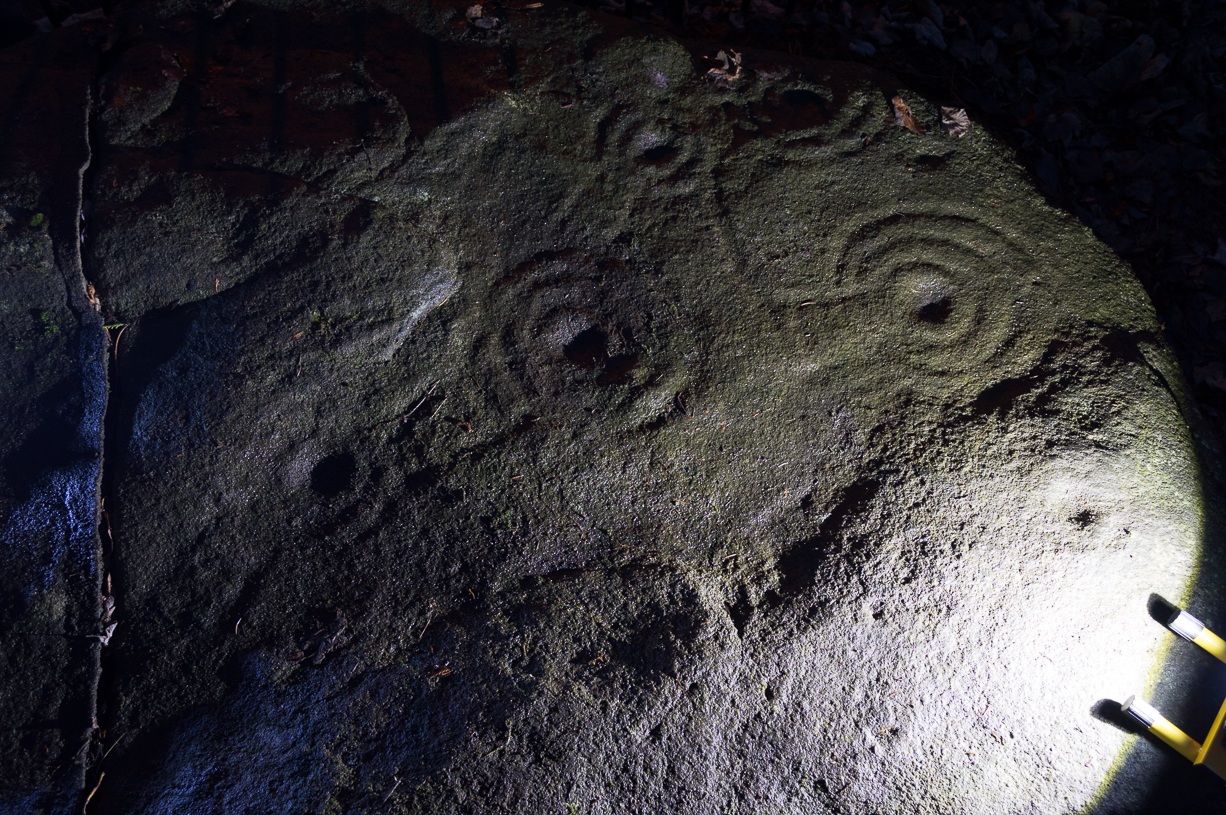
Close-up of faint ladders (by James Elkington)Close-up under lighting (by James Elkington)
If however, we do use Mr Edwards’ reasoning: take a look at the modern “accurate” drawing of this carving in Boughey & Vickerman’s (2003) book—which actually, somehow, misses elements of the carving that are clearly shown in Mr Pawson’s 1890’s photo and are still visible to this day! What are we to make of that? Have these modern folk been at it with the sand paper!? We can only conclude that these simple errors show a lack of research. The most worrying element here is that a local archaeologist can make such simplistic errors in his analysis of prehistoric and Victorian carvings without checking over publicly accessible data. Even more disconcerting was the fact that he was running Ilkley’s local prehistoric rock art group!
However, we cannot dismiss out of hand the words of the said Ambrose Collins in his proclamation of carving stones on the moors, as there is clear evidence that he did a replica of the Swastika Stone on rocks near the original site of the Panorama Stones. The carving he did is very clearly much more recent. We have also found one carving with Collins’ initials — ‘A.C.’ — carved on it and the date ‘1876’ by its side.
And although we can safely dismiss the Edward’s Theory about the Panorama Stones “ladders”, we may need to reconsider a number of other carvings on Rombald’s Moor as potentially Victorian in nature using the rationale Edwards proclaimed. For example — and using the disproved Edwards Theory — when we look at Romilly Allen’s drawing of the famous Badger Stone (from the same essay in which his image of the Panorama Stone is here taken), much of the carving as it appears today was not accounted for in the drawing. We can also look selectively at many other cup-and-rings on these moors and find discrepancies in form, such as with the Lattice Stone on Middleton Moor, north of Ilkley, or the eroded variations on the Lunar Stone. We have to take into consideration that some may have been added to; but more importantly, we must also be extremely cautious in the movement between our idea and the authenticity of such an idea. It is a quantum leap unworthy of serious consideration without proof. (though the example of the Lattice Stone has a markedly different style and form to the vast majority of others on the moors north and south of here. Summat’s “not quite right” with that one and the comical Mr Collins might have had his joking hands on that one perhaps…)
One very obvious reason that a number of the cup-and-ring carvings were not drawn correctly by historians and archaeologists alike, would be the weather! Archaeologists are renowned for heading for cover when the heavens open, quickly finishing their jottings and running for cover — and this would obviously have been the case with some of the drawings, both early and modern. Bad eyesight and poor lighting conditions is also another reason some of the carvings have been drawn incorrectly, as a number of modern archaeology texts — including a number in Boughey & Vickerman’s (2003) book — illustrate to all competent students.
There is still a lot more to say about this fascinating group of carvings, which I’ll add occasionally as time goes by. And if anyone has any good clear photos of the stones showing the intricate carved designs that we can add to this profile, please send ’em in (all due credit and acknowledgements will be given).
References:
Allen, J. Romilly, “The Prehistoric Rock Sculptures of Ilkley,” in Journal of British Archaeological Association, volume 35, 1879.
Bennett, Paul, The Panorama Stones, Ilkley, TNA: Yorkshire 2012.
Boughey, Keith & Vickerman, E.A., Prehistoric Rock Art of the West Riding, WYAS: Leeds 2003.
Cowling, Eric T., Rombald’s Way, William Walker: Otley 1946.
Downer, A.C., “Yorkshire Archaeological and Topographical Association,” in Leeds Mercury, August 28, 1884.
Hadingham, Evan, Ancient Carvings in Britain, Souvenir Press: London 1974.
Hedges, John, The Carved Rocks on Rombald’s Moor, WYMCC: Wakefield 1986.
Heywood, Nathan, “The Cup and Ring Stones of the Panorama Rocks”, in Trans. Lancs & Cheshire Anti. Soc.: Manchester 1889.
Hotham, John Paul, Halos and Horizons, Hotham Publishing: Leeds 2021.
Speight, Harry, Upper Wharfedale, Elliott Stock: London 1900.
Acknowledgements: Huge thanks to the staff at Ilkley Library for their help in unearthing the old drawings and additional references enabling this site profile.


")
")


")
")
")

")
")

")
")