From Skipton town centre follow the A6131 road south, out of town, for less than a mile, and turn left up Cawder Lane. Avoid following the road into the housing, instead bearing up the country lane to your left. Just before reaching the farmhouses 200 yards up, note the stony hilltop above you on your left (up behind Horse Close Farm). Walk up there for 250 yards NE and you’ll find it!
Archaeology & History
Horse Hill enclosure, looking W
This is an impressive site. I’d say very impressive! (but I’m easily pleased) Oddly however, I can’t find a damn thing about this place in any of my archaeo-records and it appears (as far as I’m aware) that no survey has ever been made of it. Which is bloody incredible! Indeed, the only archaeological notes that appear to exist about this very impressive and well-preserved Iron Age enclosure, states, “Subcircular enclosed settlement on Horse Close Hill 250m north of Horse Close Farm.” That’s it! Nothing else! So I’m afraid you’ve only got my crappy description of it to go on for the time being…
As the aerial image below shows, this is a large oval-shaped enclosure, defined primarily by an almost complete ring of double walling arranged around this hilltop site. Measuring approximately 78 yards (71m) north-south, and nearly 75 yards (70m) along its longer east-west axis, with a circumference of about 235 yards (215m), many of the upright stones which define its edges stand between 1-3 feet in height. Some of these stones have obviously been moved into position by the lads who built the structure, but the site has also taken advantage of a number of large earthfast boulders in its construction.
If you walk around the edges of the walled enclosure, almost every bit of it is clearly visible. Between the defining inner and outer walling of the structure we find sections of the site packed with smaller stones, giving the impression that it may once have been filled all round, making the walls thick strong defensive ones. But without a more detailed investigation, we’ll never really know…
Horse Close settlement, looking NEAerial view of enclosure
It is clearly very similar in structure, and probably date, to the well-known Brackenhall circle on Shipley Glen, near Baildon (though the nature of the Brackenhall site has long been a topic of controversy). And, as with the Brackenhall site, a number of cup-and-ring stones are found close by — including the Great Wood Laithe carving in the field immediately below on the west side. I’ve also found a similar structure to this on the hills above Steeton, a few miles to the south (though it’s not as well-defined as this one).
Although the site is mainly defined by its oval walling, we also find other stretches of walling that run outwards from the central site: one in particular running north-east for 35 yards out towards a small standing-stone further up the field. Other curious earthworks and remains scatter the fields on the eastern sides of this main feature, which the helpful farmer here pointed out to us.
Bronze Torc found at siteDetails drawn by R.Sheppard
In August, 1984, a Mr James Rickett was out with his metal-detector, scanning the Swinston woodland area south of Dinnington, when he was fortunate to locate a superb, ornamental ‘Celtic’-design bronze torc, thought to be of Romano-British origin, and believed to have been made in either the 1st or 2nd century AD. Following Mr Rickett’s discovery, a small team from the Sheffield City Museum and the South Yorkshire Archaeoloogy Unit got off their backsides and did a survey of the region where the torc had been found —and they weren’t to be disappointed!
An initial assumption based on place-name evidences led them to believe that a settlement of the Saxon period may once have been here; but their investigations
“located the earthworks of a sub-rectangular enclosure, 40m by 25m, and possible fields about 140m south of the discovery site (South Yorkshire SMR record no.PI3021). The enclosure is sub-divided into a smaller and a larger compound with no surface evidence for ditches associated with the stony banks, which enclose a total area of about 0.1 hectares. In both size and shape it compares closely with the class of very numerous small ditched enclosures… The origins of some may lie in the late Iron Age, but fieldwork and excavation have produced predominantly Romano-British material. Other local metal detector finds, some from this enclosure, include first- to fourth-century Romano-British material.”
References:
Beswick, Pauline, Megaw, M.R., Megaw, J.V.S. & Northover, Peter, “A Decorated Late Iron Age Torc from Dinnington, South Yorkshire,” in The Antiquaries Journal, 70:1, 1990.
Various ways here. From Keighley, go up the Halifax Road, first left after the Ingrow West train station, uphill, then up the long zizaggy road till you hit the pub at the crossroads. Park up and walk along the road in front of the pub for 1-200 yards and look at the hill above you! Alternatively, from Bingley go up to Harden on the B6429 and literally just where the village ends, there’s a small right-turn (if you’re going past the fields on either side, you’ve just missed the turning!). Go up there till the road reaches the top and stop! Catstones Hill is in the heather over the wall on your left!
Archaeology & History
A somewhat anomalous earthwork site, with lots of archaeohistorical speculation behind it, but no firm conclusion as to its precise nature as yet. Defined variously as an earthwork, an enclosure (for both people and cattle!) and a settlement by respective archaeologists over the years, there is little to be seen of the place on the ground and it doesn’t tend to bring raptures of delight to the common antiquarian. When William Keighley (1858) described this place, Catstones Ring was,
“enclosed on three sides by a considerable bank of earth, and bears evident marks of the plough. The country people believe it to have been an intrenchment or camp.”
Mrs Ella Armitage (1905) thought this site may have been “a prehistoric fort,” but said little more about it. In the same year however, Mr Butler Wood (1905) gave us a much better account of the place, describing Catstones Ring as “the most striking earthwork in the neighbourhood of Bradford.” His broader description told that:
“It encloses the crest and slope of a hill, and measures 266 yards on the east side (which is perfect), and 100 yards on the north side; the latter, however, being traceable at least 100 yards further across cultivated fields. The south side is almost obliterated by quarries, while the western portion has disappeared altogether. The fosse which surrounded this fine fortification is still visible on the eastern side.”
A couple of years later two short notes were made of the site in Forshaw’s Yorkshire Notes and Queries. Peter Craik (1907) of Keighley described the dimensions of the main ring as being “110 x 320 yards (rough guess),” and he also described finding the remains of a cairn in the outer dyke section (marked as ‘X’ on Craik’s diagram, below). On the nature of the site, he wrote:
“Catstones would appear to have been built as a defence against invasion from the south, for in contrast to the early defensible approach from that direction is the fact that to the north lies the undulating expanse of Harden Moor, which for the most part is on a level with the ring, even the highest point in the immediate vicinity being without the main circle, though enclosed in a minor outwork. The large extent of the ring makes it rather difficult to believe that enough men could be collected in the immediate neighbourhood to man the lines satisfactorily; and again as a shelter for cattle, etc, in time of war it does not appear to be well designed, for most of the interior would be commanded within easy range of arrows. Certain old excavations exist within the ring; probably they were made in search of gravel or some such material, but is this conjecture certain? Can they possibly mark the site of dwellings?”
J.J. Brigg (1907) followed up Craik’s short piece with the suggestion that the site was Roman in origin, saying:
“In showing the 6in map to Professor Bosanquet of Liverpool…he said there was no reason why it should not be Roman, merely because there is no masonry. The Roman legions went into laager* every night, and it is quite possible that some very large body of soldiers halting there for the night might have thrown up an earthwork and planted thereon the stakes which they always carried with them for that purpose.”
But I think this is most unlikely. Very little has been found here to give us a better idea of dates and function; and in a limited excavation here in 1962, no artifacts of any kind were located. A little more recently, J.J. Keighley (1981) has suggested the site to be Iron Age in date, describing it as one of the most impressive sites of its kind in the region. The Catstones Ring is “a 6.5 hectare quadrangular ditched enclosure,” he wrote, which he thought had been much destroyed by the adjacent quarrying.
“Aerial photographs taken by the County Archaeology Unit in 1977 however, shows that the southeastern corner of the enclosure and parts of its southern ditch survived the quarrying. Villy (1921) observed an outwork to the north of the main enclosure, which was visible on aerial photographs taken in 1948, and the 1977 aerial photographs…show a possible annexe attached to the outside of the northeastern corner of the main enclosure.”
P. Craik’s 1907 drawing
This extended section of Catstones’ main earthworks were, in fact, first described in the article by Peter Craik (1907), as shown in the hand-drawn plan of the site here. And in all honesty, virtually nowt’s been done since these early antiquarians diggings and essays. The information from the present day Sites and Monuments Record says that the site is a “late prehistoric enclosed settlement” and that quarrying has destroyed much of the west side.
Folklore
Harry Speight (1892) reported the earthworks here to have been a site where a great battle once took place, between the local people and the early Scottish tribes.
References:
Armitage, E., ‘The Non-Sepulchral Earthworks of Yorkshire,’ in Bradford Antiquary, New Series 2, 1905.
‘Standing Stone’: OS Grid Reference – SS 8896 3355
Getting Here
You can’t really miss this. Take the road south from Winsford, up the steep hill onto the moors and before you reach the crossroads, look up across the slope on your left where you’ll see a small building on its own. Go there!
Archaeology & History
A curious upright monolith more than five feet long (though some of this is embedded in the ground) with the words ‘CARAACI NEPVS’ carved on one side, is strangely closetted in a silly ‘house’ of its own on the moortops! But the origins and history of the stone are contentious. Some proclaim it as prehistoric, others Romano-British, and others as being from the Dark Ages. In the 1960s and ’70s, archaeological tradition had its origins in the Romano-British period, and certainly the carved lettering on the sides of the stone seem to indicate a Roman provenance; but as the great Exmoor historian S.H. Burton (1974) told,
“It is possible that the stone was erected hundreds of years before it was inscribed, and the existence of an ancient trackway alongside, leading to the Barle, strengthens this possibility. But, like most things about the Caratacus Stone, this is guesswork.”
We know it stood here in the 13th century as it was described in perambulation records of 1219 and 1279 AD; but it’s more than likely to be a monolith erected in the Dark Ages. Grinsell (1970) however is a little more cautious, telling:
“The likelihood of the person in whose memeory this stone was raised claiming kinship with the Caratacus who was the arch-enemy of Rome, c. AD 45-50, has on more than one occasion been questioned. It is, however, too tempting to be abandoned by the present writer.”
The carving on the stone was deciphered by the legendary Prof. John Rhys at the end of the 1800s, telling it to have been Carataci Nepos, the Kinsman of Caratacus (and variants thereof), who held out against the Romans in south Wales until AD 50. The old Celtic writer, R.A.S. Macalister, thought the stone to have been dedicated to a local christian hero, St. Carantoc, but this notion has been generally dismissed.
Folklore
The old stone is said to be a site where buried treasure exists — though none has ever been found. There is also an old tradition that “ghostly horses and waggons rumble towards the stone at midnight” — but this as likely relates to its proximity with the old crossroads a short distance away.
References:
Burton, S.H., Exmoor, Hale: London 1974.
Grinsell, L.V., The Archaeology of Exmoor, David & Charles: Newton Abbot 1970.
Page, John Lloyd Warden, An Exploration of Exmoor and the Hill Country of West Somerset, Seeley 1890.
Vowles, Alfred, History of the Caratacus Stone, privately printed 1939.
Fortunately for the person who lives here, this much overgrown and denuded remains of a fabled tumulus is in their garden! The mound is divided by a hedge in the back garden, up near the bend of where Fitzwalter Road meets St. Clare Road and the school field backs onto them. I’ve no idea whether the people who own the gardens are OK with you visiting the site or not. If you wanna look at it, I s’ppose the only thing to do is knock on their door and ask!
Archaeology & History
Plan of the Lexden tumulus (Laver, Archaeologia 1927)
Ascribed as late Iron Age, some of the finds here are distinctly Romano-British. Indeed, excavations here by P.G. Laver in 1924 uncovered rich Belgic remains akin to the chariot burials found in East Yorkshire! (though not quite as good as them) There was a considerable collection of gold, silver and other metalwork remains here, along with considerable remains of pottery aswell. It seems there was a tradition of burials here, with some evidence dating from the Bronze Age — but the majority of remains found in the excavations were from the much later period. One account attributes the burial mound to have held the body of Cunobelin; the other, the body of Addedomaros of the Trinovante tribe.
Folklore
Quoting from an earlier source (A.H. Verrill’s Secret Treasure, 1931), in Leslie Grinsell’s (1936) fine early survey on British prehistoric tombs, he described the legend of there being hidden treasure here, saying that locally there was
“a belief that it was the burial place of a king in golden armour, with weapons and a gold table.”
But was this legend described anywhere before P.G. Laver’s excavation of the site in 1924…? It would be very intriguing if we could find this out!
References:
Grinsell, Leslie V., Ancient Burial Mounds of England, Methuen: London 1936.
Laver, P.G., ‘The excavation of a Tumulus at Lexden, Colchester,’ in Archaeologia journal, no.76, 1927.
You can’t really miss this. Roughly halfway along the B1383 London Road between Littlebury and Wendens Ambo, just above Chestnut Avenue, a dirttrack on the west-side of the road takes you up and onto the wooded hillside. Where the track splits in two, head straightforward up and into the trees until it opens into the clearing. You’re there!
Archaeology & History
This great monument had already been described several times before the Domesday Book had even been thought about! Indeed, it seems that the town itself gets its name from the hillfort! (Reaney 1935) Nowadays the place is just about overgrown and covered in woodland. You cna make out various undulations where parts of the ditches are apparent, but it could do with a clean-out. Thought to be Iron Age, Nick Thomas (1977) described the site as,
“Oval in plan, this fort follows the contour of the hill it encloses, protecting about 16½ acres… the defences consist of a bank, ditch and counterscarp bank, of which only the ditch is well-preserved.”
References:
Reaney, Paul, The Place-Names of Essex, Cambridge University Press 1935.
Thomas, Nicholas, Guide to Prehistoric England, Batsford: London 1977.
Travelling up (north) the A19, just as you get to Riccal village, there’s a small road to your right: take this! A mile along there’s a parking place just where the track veers into the woods. That’s where you’re heading. The remains of the tombs hereabouts can be hard to discern – but if your lucky you’ll either meet a local, or the virtue of patience will bring these overgrown tombs into focus! There are other tumuli a few hundred yards east and north of here aswell. If you wanna get a clear picture of them all, a full day would be a good bet!
Archaeology & History
Not to be confused with the other Danes Hills tombs a couple of miles northeast of here (as done on some other sites), the early Victorian geologist and explorer John Phillips (1853) was one of several early writers who described what, today, are known to be Iron Age tombs, scattered about a short distance east of Riccall village, saying:
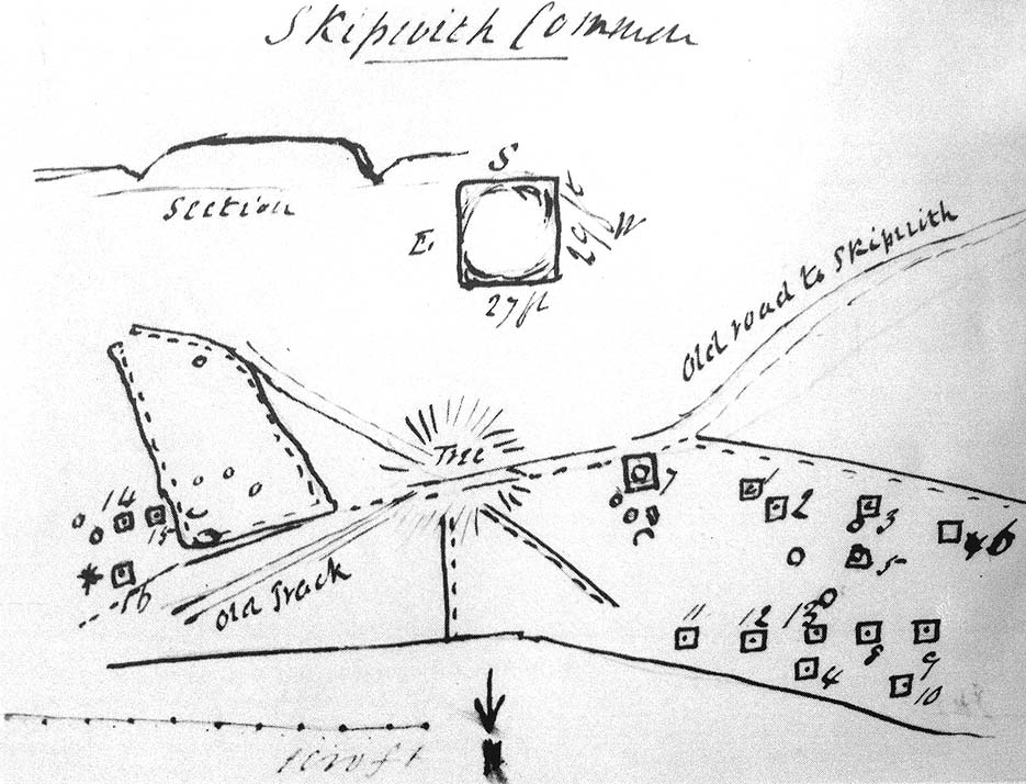
“On Skipwith Common are many tumuli, old banks, and the slightly-marked foundations of ancient (turf or log?) houses or wigwams. These, by some error of tradition, are called ‘Danes’ Hills/ but, on opening the tumuli, no confirmation of so modern a date appeared. The tumuli are set in square fosses; the sides of the fossae range north and south and east and west (true). Similar facts appear in connexion with the tumuli on Thorganby Common adjacent. Burnt ashes and bones occur in the mounds; facts which suffice to overthrow the supposition of these hills being funeral heaps of the Danes of the llth century, for they then buried their dead. No instruments of metal, bone, or stone, or pottery were found.”
There were dozens of tombs that could be seen here in the past, but today many have been destroyed or are hidden by the cover of trees. A sketch-map (above) showing the rough location of many of the graves was made by the Yorkshire Antiquarian Club after a visit here in 1849 (Proctor 1855), who opened several of the barrows. Archaeologist Ian Stead (1961; 1979) defined these remains as being of the famous La Tene burials — though I’m unsure as to whether any of the tombs here had the great horse-chariots found in them, as found in the more famous Danes Graves tombs close to Driffield.
Folklore
The name of these small hills acquired their Danish title via a mix of real history and folklore. History tells of the old Danish King Harald Hardrada, who moored his fleet of ships a few miles away from here before going into battle against the armies of Northumbria and Mercia. “Dane’s Hill,” said Bogg (c.1895), “still marks the spot where the fight took place.” As John Burton (1758) told us:
“Ever since the aforesaid battle, it is by tradition to this day said, that the Danes were permitted to encamp here till they had buried their dead, and their ships at Riccal should be ready for their re-embarking for Norway.”
Local folk used to tell of the tradition of the local swamp — called Riccal Towdyke — being choked with the bodies of many slain in the battle hereabouts. Many pieces of red cloth were found all around in the neighbourhood of these tombs. However, despite this mix of fact and folklore, the tumuli were see marked on the modern OS-maps have been found to be Iron Age in origin.
…to be continued…
References:
Bogg, Edmund, From Eden Vale to the Plains of York, James Miles: Leeds n.d.
Burton, John, Monasticon Eboracense, N. Nickson: York 1758.
Elgee, F. & H.W., The Archaeology of Yorkshire, Methuen: London 1933.
Morrell, W. Wilberforce, The History and Antiquities of Selby, W.B. Bellerby: Selby 1867.
Phillips, John, The Rivers, Mountains and Sea-Coast of Yorkshire, John Murray: London 1853.
Proctor, W., ‘Report of the Proceedings of the Yorkshire Antiquarian Club, in the Excavation of Barrows from the Year 1849,’ in Proceedings of the Yorkshire Philosophical Society, 1855.
Stead, I.M., ‘A Distinctive Form of La Tene Barrow in Eastern Yorkshire,’ in Antiquaries Journal, volume 41, 1961.
Stead, I.M., The Arras Culture, Yorkshire Philosophical Society: York 1979.
Taking the A629 road between Shepley and Ingbirchworth, as you hit the staggered crossroads at High Flatts, take the west turn up the slightly sloping straight road of Windmill Lane. Just where the road ‘kinks’ at a small bend, stop and look into the field on your left.
Archaeology & History
Deemed by some as a hillfort, and others as settlement remains, what little are left of the remaining earthworks here were first described by local historian Henry Morehouse in 1861. Found about a mile west of Upper Denby, the site was described in the Victoria County History as being “on a commanding though not exactly a defensive situation on the slope of a hill.” This remark coming from the belief (and that’s all it is) that this was an Iron Age castle site. In 1924 James Petch said of it,
“The earthwork seems originally to have been almost square, and two sides and an angle remain. The external ditch is from ten to twelve feet broad in its present state.”
While Faull & Moorhouse (1981) tell of there being “evidence for Neolithic activity” here, modern surveyors reckon it as an old prehistoric settlement — which makes sense; though little of the site remains to be seen today.
References:
Faull, M.L. & Moorhouse, S.A., West Yorkshire: An Archaeological Survey, I, WYMCC: Wakefield 1981.
Morehouse, Henry James, History and Antiquities of the Parish of Kirkburton and the Graveship of Holme, Roebuck: Huddersfield 1861.
Petch, James A., Early Man in the District of Huddersfield, Huddersfield 1924.
A beautiful place found along the roadside towards Seil Island, on the B844 a few miles south of Oban. When you get near the south end of the loch right by the road, have a gander! If the waters are low you can sometimes see the ghostly island appear above the waves…
Archaeology & History
You’re lucky to see anything here – as the crannog has all but submerged. This old artificial island could once be clearly seen less than 400 yards south of Duachy farmhouse, near the southwestern edge of the loch. It measured roughly 10 yards by 8 yards, was built of stones, seemingly “with a boat-slip on the west side and a ‘square place’ on the east as if for a landing stage.” All trace of the causeway linking it to the shore has apparently vanished. But if you do stop here, check out the Duachy Standing Stones on the hillside behind you!
References:
Royal Commission on the Ancient & Historical Monuments of Scotland, Argyll – volume 2: Lorn, HMSO: Edinburgh 1974.#
Described by Steve Ford (1987) as “the only known example of a hillfort in East Berkshire,” this much overgrown site encloses an area covering 7.8 hectares. It was first started around 700 BC and thought to be a northern outpost for the Atrebates tribe. However, just over the northern edge of the ramparts, less than half a mile away, a group of seven round barrows were once in evidence, indicating that the the flat plateau on which the hillfort stands would have been of use prior to its construction (Hawkes 1973). The site is described as follows:
“The earthworks consist of a single bank and ditch on the northwest, while elsewhere there is an additional outer bank. At the southern side, the ramparts include a second ditch and a third bank… At present there are four entrances: north, south, east and west, but it would seem that only the eastern and western entrances are contemporary with the construction of the hillfort.”
Archaeologists discovered that the site was made use of by the Romans when their mob arrived, as a coin of Cunobelin as well as Roman pottery was uncovered — although it has to be said that, as a Roman road passes by a short distance to the south, so such finds would be expected.
References:
Ford, Steve, East Berkshire Archaeological Survey, Berkshire County Council 1987.
Hawkes, Jacquetta, Prehistoric and Roman Monuments in England and Wales, BCA: London 1973.


")
")
")