Standing Stone (destroyed): OS Grid Reference – NS 681 490
Archaeology & History
This is another Lanarkshire monolith that’s gone, but which was described first of all in the 19th century in the Ordnance Survey place-name book for the county. The Scottish Royal Commission (1978) lads—who tried locating the site in September, 1973—told that,
“no trace now survives of the stone, 1.4m in height (i.e., about four-and-half feet tall – Ed.), that once stood in a field beside the public road about 120m northeast of Shawton Farmhouse.”
References:
Royal Commission on the Ancient & Historical Monuments, Scotland, Lanarkshire: Prehistoric and Roman Monuments, HMSO: Edinburgh 1978.
Standing Stone (destroyed): OS Grid Reference – NS 832 426
Archaeology & History
The first reference I found of this once-proud standing stone was in the early pages of the Glasgow Archaeological Society’s Transactions, from 1897; but when the Royal Commission lads came to look for the site in 1971, it had long-since been destroyed. Thankfully we have various folklore relics to tell us more!
Folklore
In Robert Chambers’ Popular Rhymes (1826), he told us several intriguing pieces of folklore about this once great monolith, writing:
“On the farm of Clerkston, in the parish of Lesmahagow, there had existed since creation an immense stone, or saxum, which, being deeply bedded in the middle of a good field, at a great distance from any other rocks, was productive of infinite inconvenience to the husbandman, and defrauded the proprietor of a considerable portion of territory.
“Beneath this stone, it was believed by the country people of the last generation, that there was secreted a vast treasure, in the shape of “a kettle-full, a boot-full, and a bull-hide-full,” of gold; all which got the ordinary name, reason unknown, of “katie Neevie’s hoord.” The credibility of this popular tradition was attested by a rhyme to the following effect:
Between Dillerhill and Crossfoord,
Here Lies Katie Neevie’s Hoord.
“Many efforts had been made, according to the gossips, to remove the stone, and get at the treasure; but all were baffled by the bodily appearance of the enemy of mankind, who, by breathing intolerable flame in the faces of those making the attempt, obliged them to desisted. Thus well guarded, the legacy of Mrs. Katherine Niven lay for centuries as snug as if it had been deposited in Chancery; and it was not till at least an hundred years after the last despairing effort had been made that the charm was at length broke.
“Mr James Prentice, the present farmer of Clerkston, had the address to convince several Irishmen, who had served him during the harvest, of the truth of the said rhyme; and, by expatiating upon the supposed immensity of the treasure, wrought up their curiosity and their cupidity to such a pitch, that they resolved, with his permission, to break the stone in pieces, and make themselves master of whatever might be found below. On the day after the kirn, therefore, the poor fellows provided themselves with a well-loaded gun, for the protection of their persons from the Devil, and fell to work, with punches and mallets, to blow up and utterly destroy the huge stone which alone intervened between them and everlasting affluence.
“They laboured the whole day, without provoking any visit from Satan, and at last succeeded in fairly eradicating the stone from the field which it had so long encumbered; when they became at once convinced of the fallacy of the rhyme, of the craft of Mr. Prentice, and of their own deluded credulity.”
References:
Chambers, Robert, The Popular Rhymes of Scotland, William Hunter: Edinburgh 1826.
Royal Commission for the Ancient & Historical Monuments of Scotland, Lanarkshire: Prehistoric and Roman Monuments, HMSO: Edinburgh 1978.
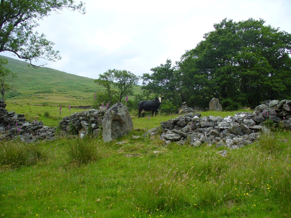
From Killin, travel down Glen Lochay, past Stag Cottage or Duncroisk and over the shallow river of Allt Dhun Croisg. If you’re in a car you can park up a 100 yards past the river bridge and walk up the track from here. After a 10 minute walk, above the trees you come to the derelict village of Tirai* where, until recently, you were greeted by a tall totem-pole of a gnarled tree (it was superb!) which is now Earth-lain, and a fine view of the evolving hills. Here amidst the ruins we also find a standing stone or two.
Archaeology & History
The village of Tirai was deserted sometime in the 19th century (due to the disgusting clearances of the English), but at least two standing stones still live amidst its ruins. The tallest is nearly four-feet tall in the middle of the grassy patch and is much used by grateful cattle to rub themselves against when midges and horseflies drive them mad! The Scottish Royal Commission lads reckon the megaliths here are,
“possibly a survivor of a stone circle as a similar stone is used nearby as a gate-post to an enclosure and several other large stones have been incorporated in the walls of the surrounding buildings.”
This may well be so – but it is equally possible that these are merely the remains of standing stones which once stood along this ridge and which were taken for use in the village.
One of the Tirai standing stones
Of the remaining standing stones in this idyllic setting – the Royal Commission fellas counted possibly four of ’em – all are roughly the same size, between 3 and 4 feet high. Johnstone & Wood (1996) also think the stones here may once have related to a prehistoric cairn in the village.
This is an utterly beautiful arena, even in the heights of winter. The village sits on the rear slopes behind the old cailleach, and there are plenty of cup-and-ring carvings, both known and unknown scattering the rocks and nearby hills. The curious Duncroisk Crosses carving is just visible from here, on the other side of the rocky gorge. Lost tales and lost sites abound here also. I did sit and wonder though… Considering that the villagers here left the old standing stones in place until very recent centuries at the heart of their hamlet, what uses did they make of it, or what tales did it speak? Or had the purge of the Church already taken its toll…?
References:
Gillies, William A., In Famed Breadalbane, Munro Press: Perth 1938.
Johnstone, A.S.K. & Wood, J.S., ‘An Archaeological Field Survey of Deserted Townships at Tirai, Glen Lochay, Killin,’ Association of Certificated Field Archaeologists (Glasgow University) Occasional Paper no 9 (1996).
* The place-name Tirai means ‘land of good luck or joy,’ which truly speaks well of its spirit and setting to me.
Another silly-sounding directional pointer! Get to the now tourist-infested town of Killin (best in Winter, when the town is quiet and you get to know the locals a lot better) and travel through it as if you’re going to follow Loch Tay up its western side. As you’re going out of the village towards the Bridge of Lochay Hotel (an excellent place), you’ll see an amphitheatre of mountains in the background. The tallest of the hills on the left is where you’re heading. Go straight up the hillside and follow your nose!
Creag na Cailleach, Killin
The hill guards the entrance to the legendary Glen Lochay (Valley of the Black Goddess). There are many ways to climb her, but my first venture here took me up the waterfalls and steepish burn of Allt na Ceardaich. Once on the level, I found myself surrounded by that amphitheatre I mentioned, from where – on my first visit – I took up the sheer face of this great mountain. (to be honest it’s nowt special if you’re into mountaineering) From the tops you’ve got a damn good view all round. But respect this old hill, as danger awakens to idiots who would think themselves champions.
Folklore
Here, where axes were quarried by ancient man from beneath Her rocky slopes, this ‘Hill of the Old Woman’, or ‘Hag’, was one of the abodes of the primal Mother Goddess in olden times, so says her name. Her ‘dark’ aspect seemed manifest one time when I climbed her with a rather stupid man in tow. Following one of the streams back into the valley below, he thought it wise to copy my gazelle-nature as I sprang without thought, quickly, from rock to rock, bouncing at speed down the fast-flowing stream (which takes a lotta weird practice and very strong ankles!), in spite of the advice to do otherwise – and in doing so he broke his leg in three places and, to make it worse, had to spend the night there in complete agony!
Don’t tell me there’s no ‘dark’ goddess to some of these great places!
Axe production has been found to have occurred as early as 2500 BC. There have been numerous flint finds hereabouts aswell – but considering this is a mountain, you’d expect to find something on or about Her slopes!
I’ve just been back up here as the first good snow fell upon the hills and the white cover brought the elements out of her form in a way I’d not seen before. Tis a wonderful place the Creag na Cailleach; and, it seems, a site that played a now forgotten part in the ancient name of the glen, Lochay, which was the living abode of the Black Goddess in more archaic days. Twouldst be good to hear some of the authentic old stories from old locals that were once known of this ancient deity in the glens. If anyone knows of such tales, let us know before they are lost forever…
References:
Ritchie, P.R., ‘The Stone Implement Trade in Third Millenium Scotland,’ in Coles & Simpson’s, Studies in Ancient Europe, Leicester University Press 1968.
Acknowledgements: Huge thanks to Lindsay Campbell for her hospitality, food and roof hereby.
Settlements (destroyed): OS Grid Reference – SX 677 653
Archaeology & History
Prior to the submergence of one of the many prehistoric settlements in and around the waters of the Avon Reservoir, excavation work was carried out by Lady Aileen Fox between 1954 and 1956 on behalf of the Ministry of Works. The excavation notes in the Proceedings of the Prehistoric Society for 1957 told what Lady Fox and her fellow archaeologists found at the site that was due to be submerged:
“The walled enclosure of 2½ acres contained nine huts from 15-20 feet in diameter and three pens built against the outer wall. The huts were roofed in the same way as those as Kestor, having a central post and a ring of six or seven uprights supporting the main rafters. Part of the settlement was incorporated into a medieval farmstead, but the prehistoric occupation proved to be from the local Late Bronze Age.”
Since that report, a number of other prehistoric settlement sites have been found on the surrounding moorland heights (as a quick look at the OS-map clearly shows). Obviously a very busy place in ancient days!
References:
Clark, J.G.D. (ed.), “Notes on Excavations in Eire, England, Northern Ireland, Scotland and Wales during 1956,” in Proceedings of the Prehistoric Society, volume 23, 1957.
Not too hard to find really. On the far western edge of the King’s Park golf course, head for the highest point where the small cliffs drop down. From here, walk down the footpath on the slight slope south, just below where the small copse of trees are, and you’ll see the singular small flat stone in the grasses near the footpath you’re walking along. If you can’t find it – look around!
Archaeology & History
A little-known but fascinating isolated carving, first described by David Morris at the sixth meeting of the Stirling Natural History and Archaeological Society in 1901. It is found on the western edge of the town, above the rocky edges not far from the pond of St. Thomas’ Well on the far edge of the golf course. Morris’ finding was written up in their fine journal, where he wrote:
“In the King’s Park, about 50 yards east of the cliff where a seat overlooks the Douglas Terrace sand quarry, there is a smooth surface of rock showing through the turf, measuring two-and-half feet by one-and-half feet… On it is a cup-shaped hollow, outside the rim of which is a well-marked hollowed ring, beyond which is another faintly marked, concentric circular groove. The cup-mark measures one-and-a-half inches across; the inner rim of the first circle is 4 inches, and the outer rim is 6 inches in diameter. The outer circle, if complete, would be 9 inches in diameter. The depth of the central hollow is half-an-inch, and of the inner groove fully one-quarter of an inch. The markings are plainly artificial…”
King’s Park CR – central design, pointing to northernmost cup
In good sunlight, it is obvious that the carving is a fine example of a double-ringed cup-and-ring carving – though the outer ring may not be complete. The Scottish Royal Commission lads told that “this rock outcrop bears three cup marks” – one of which has the rings surrounding it. In the first photo here, the southernmost cup-marking is highlighted in the centre of the two shells which were on the rock when we arrived.
However, there’s definitely more to this carving than previous investigations have outlined. It seems that the northernmost cup-mark has a ring and a possible outer-ring. There is also a distinctive linear carving, which at first seems like a primitive triangle, just below the southernmost cup – as we’ve tried illustrating here in the photo which Mikki Potts took. It’s faint, but once you see it, it’s obvious that it’s there. Other faint lines of similar nature also seem apparent near the northernmost cup-marking, but we will have to wait for rubbings and further visits in better light to ascertain the full image on this rock. Well worth checking out if you like your rock art! (can any of you Scottish rock-art fanatics have a closer look at this? – take a rubbing of it and see what other aspects are on this design)
Faint linear carvings on southern end of the rock
One other thing which seemed apparent when we were here: this site has all the geomantic hallmarks of accompanying a burial at some time in the ancient past. Its isolation here is unusual and the carving is only 50 yards from the highest point hereabouts, where you have 360-degree views all round, typifying the position of many prehistoric tombs.* Does anyone know about such features, or have records of any field-name surveys taken, which might confirm or deny this thought? Twouldst be good to know!
References:
Feachem, Richard, Prehistoric Scotland, Batsford: London 1963.
Morris, David B., “Cup and Ring Marked Rock Surface in King’s Park,” in Stirling Natural History & Archaeology Society Transactions, 1900-1901.
Morris, Ronald W.B., The Prehistoric Rock Art of Southern Scotland, BAR 86, Oxford 1981.
Royal Commission on the Ancient and Historical Monuments of Scotland, Stirlingshire – 2 volumes, HMSO: Edinburgh 1963.
Royal Commission on the Ancient & Historical Monuments of Scotland, Archaeological Sites and Monuments of Stirling District, Central Region, Society of Antiquaries of Scotland 1979.
* Since writing the above, thanks the correspondence of Paddybhoy, we’ve learned that there definitely were prehistoric tombs close by; one being just at the bottom of the ridge below the carving, on Douglas Terrace. Records describe several other prehistoric tombs nearby at Birkhill House, the Birkhill Sandpit and Coneypark Nursery. However, I still think it most probable that there were other tombs and more rock art, probably along the edges of King Park, aswell as the Cambusbarron plain. These need locating.
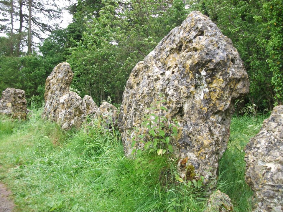
All sorts of ways to get here – all via road I’m afraid. Those southern-types aint into walking over fields and ambling about like we can do ‘ere up North. Best way to get here really, is get to Chipping Norton (a good little town with many good folk there), and ask! Take the road out of the town to Over Norton, taking the first road left as you enter the village. Go along this country lane for a mile until you reach a crossroads at the top of the hill. Turn right at the crossroads and watch out for the parking space at the roadside a few hundred yards along. Stop there and walk through the gate to go round to the other side of the trees. (if there’s a Rollright Trust member there loitering in the entrance asking you for some money to walk or sit by the stone circle – don’t give ’em it! They’ve used the cash for poisoning the wildlife in the past (killing the moles, field mice and other indigenous creatures there) and then lied about what they did (reckoning it was nowt to do with them!), so I wouldn’t trust them).
Archaeology & History
Southern arc of stones
There’s masses to be said on this site, which can’t possibly be added all in one go (I’ve literally got a full unpublished book on the many aspects of this lovely site) — so this entry will be updated occasionally with additional bits and bats of info and images as time floats by.
This remarkable and quite atmospheric megalithic complex has so much to say for itself that entire books have been written on the place (see the extensive references below), dealing with its archaeology, folklore and ritual use. I was very fortunate around the turn of the 21st century, to be able to live in an old hut that used to stand in the copse of trees just outside the circle, where I had numerous weird and wonderful experiences with people, wildlife, and what some might call the more eosteric life of the place…
1920s Ground-planMr Taunt’s 1907 plan
The King’s Men is a near-perfect circle of oolitic limestone uprights. Thought for centuries to be the memorial site of some victory by the Danish King Rollo, they have been described by many historians, travellers and antiquarians from the 14th century upwards. Several early writers described a sort of “avenue” running from the circle, not unlike the one perceived at Stonehenge and elsewhere. Evidence for this cannot be fully disregarded, as there are some recumbent monoliths along the road beside the stone complex, known as the Jurassic Way. This was a prehistoric trade route and it is more likely than not that some other uprights would have been nearby.
The Rollright Stones were used as the prime base for what was known as the Dragon Project: an exploratory examination of potential electromagnetic anomalies that were recorded at the standing stones here by scientists, geomancers and archaeologists who were involved daily monitoring work over many years. Much of this was published in Paul Devereux’s book, Places of Power – required reading for everyone who pretends an interest in megalithic sciences.
Northern section of the ring
The Rollright complex today consists primarily of three sites: the Whispering Knight’s portal dolmen, the King’s Men stone circle, and the King Stone. Of these, it is the stone circle which draws most attention. Several alignments are connected with the complex. The original ritual use of the place would have, primarily, involved rites of passage and death rituals; though it seems obvious that menstrual rites were also an important social event here. After dark, this stone circle has distinctly ‘female’ spirit, sometimes manifesting in a quite wrathful form (please don’t confuse any of the modern witchcraft mythos with such things – they are fundamentally different in both social and ritual aspects). Women obviously played a large part in the ritual use and geomantic layout of the original complex. It also seems likely that the stone circle was used as a moot spot, which may have been in use until medieval times. The recent discovery of the carving of a family crest, at least 500 years old, implies this.
Until Tom Wilson and I lived in the hut at the circle in the 1990s, previous reports of ‘carvings’ at the stone circle were few and debatable. But two of the stones in the Rollright circle have quite distinct carvings on them. The most pronounced is etched on the tallest stone (stone 1 – Barnatt Survey) and comprises of a typical heraldic shield – although we cannot, as yet, ascertain the motif in the middle of the shield. This was first seen by a visiting tourist who wanted to remain anonymous, but the finding was written up in an article I wrote shortly afterwards. (Bennett 1999) The image below – reproduced courtesy of Alistair Carty’s Archaeoptics Limited laser scanning company – clearly shows the carving, which confirmed the initial discovery. The report of his findings can be read here.
Not unsurprisingly, since the discovery of the shield various screwy interpretations have been put forward to account for the design. My favourite has to be the one suggested by a pagan friend of the Rollright Trust, who, occult-like and all secret (y’ get the drift) reckoned it was all to do with King Arthur! Needless to say, my response of, “Y’ talking bollox mate!” was received somewhat nervously by pagan Karin Attwood and the twee little entourage who were discussing the shield, in the usual ‘secrecy – secrecy’ hush-hush tone of false witches and similar idiots!
A few months later I found another set of carvings on stone 62 (Barnatt survey), comprising a set of Ogham letters. These Ogham are very faint and are best observed before midday, when lighting conditions highlight them much clearer. If anyone can decipher them, it would be greatly appreciated. (though please don’t gimme some shit about King Arthur)
Folklore
Folklore ascribes that the number of stones in the complex cannot be counted (a motif found at other megalithic sites) and, intriguingly, of the surveys done here, no two are the same! One early illustration of the circle shows 30 stones, nother describes 46, and one survey describes just 22 stones! As the 20th century progressed the numbers increased dramatically, with surveys differing at 58, 60, 71, 72, 73, 77 and 105. The present-day ‘guesstimate’ is about 77. Weird!
Folklore tells that if you can count the stones three times in a row and get the same number, you may have any wish you choose. But recently this has become reversed and it is said to be a curse if you count three times the same. Intriguingly, modern visitors who allege no superstitious beliefs, will not count the stones a third time if the same number crops up twice.
The best-known folk tale of this place is of the King, his men and the knights, who “were once men who were changed into vast rocks and fossilised,” as Camden first put it in 1586. The King’s men sometimes go to drink at a well near Little Rollright, as does the king, but he only goes at certain times. At midnight however, on certain days, the King’s Men have sometimes been known to come to life, join hands and dance in a circle. This sounds more like a folk remnant of ritual use here.
Faerie folk are said to live beneath the circle, in great caverns, some of which are linked up to the single monolith across the road. Ravenhill [1926] described how local folk had sometimes seen the little people dancing around the circle by moonlight, but nobody has seen them of late.
References:
Anonymous, The Rollright Stones: Theories and Legends, privately printed, n.d.
Anonymous, ‘Oxfordshire Mysteries,’ in The Ley Hunter 86, 1979.
Aubrey, John, Monumenta Britannica, Milbourne Port 1980.
Barnatt, John, Stone Circles of Britain (2 volumes), BAR: Oxford 1989.
Bennett, Paul, ‘Remarkable Carving found at the King’s Men Stone Circle, Rollright, Oxfordshire,’ in Right Times 5, 1999.
Bennett, Paul & Wilson, Tom, The Old Stones of Rollright and District, Cockley Press: London 1999.
Bloxham, Christine, Folklore of Oxfordshire, Tempus 2005.
Bord, Janet & Colin, The Secret Country, Paul Elek: London 1976.
Bord, Janet & Colin, A Guide to Ancient Sites in Britain, Paladin 1979.
Brooker, Charles, ‘Magnetism and the Standing Stones,’ in New Scientist, January 1983.
Burl, Aubrey, A Guide to the Stone Circles of Britain, Ireland and Brittany, New Haven & London 1995.
Burl, Aubrey, Great Stone Circles, Yale University Press: New York & London 1999.
Burl, Aubrey, The Stone Circles of Britain, Ireland and Brittany, Yale University Press 2000.
Clayton, Peter, Archaeological Sites of Britain, Weidenfeld & Nicolson: London 1976.
Cooper, Roy, ‘Some Oxfordshire Leys,’ in The Ley Hunter 86, 1979.
Cowper, B.H., ‘Oxfordshire Legend in Stone,’ Notes & Queries (1st series), 7, January 15, 1853.
Crawford, O.G.S., Long Barrows of the Cotswolds, John Bellows: Oxford 1932.
D., A.J., ‘Rollwright or Rollright,’ in Notes & Queries, 2nd series, 7, 1859.
Devereux, Paul, ‘Is This the Image of the Earth Force?’ in The Ley Hunter 87, 1979.
Devereux, Paul, ‘Operation Merlin,’ in The Ley Hunter 88, 1980.
Devereux, Paul, ‘Operation Merlin 2,’ in The Ley Hunter 89, 1980.
Devereux, Paul, ‘The Third Merlin,’ in The Ley Hunter 92, 1981.
Devereux, Paul, Places of Power, Blandford: London 1990.
Devereux, Paul, The Sacred Place, Cassell: London 2000.
Devereux, Paul, Steele, John & Kubrin, David, Earthmind, Harper & Row: New York 1989.
Devereux, Paul & Thomson, Ian, The Ley Hunter’s Companion, Thames & Hudson: London 1979.
Dyer, James, Discovering Regional Archaeology: The Cotswolds and the Upper Thames, Shire: Tring 1970.
Evans, Arthur J., ‘The Rollright Stones,’ in Trans. Bristol & Glouc. Arch. Soc., 40, 1892.
Evans, Arthur J., ‘The Rollright Stones and their Folklore (3 parts),’ in Folklore Journal, 1895.
Graves, Tom, Dowsing, Techniques and Application, Turnstone: London 1976.
Graves, Tom, Needles of Stone, Granada: London 1980.
Graves, Tom (ed.), Dowsing and Archaeology, Turnstone: Wellingborough 1980.
Gray, William, The Rollright Ritual, Helios: Cheltenham 1975.
Grinsell, Leslie V., The Ancient Burial Mounds of England, Methuen: London 1936.
Grinsell, Leslie V., The Rollright Stones and their Folklore, Toucan Press: Guernsey 1977.
Hamper, W., ‘Observations on certain Ancient Pillars of Memorial, called Hoar Stones,’ in Archaeologia, 25, 1833.
Hawkes, Jacquetta, A Guide to the Prehistoric and Roman Monuments in England and Wales, BCA: London 1973.
Higgins, Geoffrey, The Celtic Druids, Rowland Hunter: London 1829.
Krupp, E.C., In Search of Ancient Astronomies, Chatto & Windus: London 1979.
Lambrick, George, The Rollright Stones: The Archaeology and Folklore of the Stones and their Surroundings, Oxford Archaeology Review 1983. (Reprinted and updated in 1988.)
Standing Stone (destroyed): OS Grid Reference – NS 829 442
Archaeology & History
No longer here, but about 200 yards north of the old farmhouse of Blackhill (with its ancient tumulus still in attendance across the road) could once be seen a decent standing stone, “fully six feet high.” It seems that this was sadly uprooted sometime before 1954.
References:
Royal Commission on the Ancient & Historical Monuments of Scotland, Lanarkshire: An Inventory of the Prehistoric and Roman Monuments, HMSO: Edinburgh 1978.
Cup-and-Ring Stone (lost): OS Grid Reference – SE 142 396
Archaeology & History
Listed in Boughey & Vickerman’s (2003) survey as ‘stone 186,’ I first came across a reference to this carving when I was young, in a short article by Sidney Jackson (1964) in his Cartwright Hall archaeology journal. A letter was sent to Mr Jackson in 1963 by a Mr Bernard Stubbs of Baildon, who wrote:
“This morning I visited Hope Farm, Baildon, where Mr Jim Bell, the farmer, told me of a cup-and-ring boulder which he had discovered while digging a hole to bury a sheep, in the polt of land at the rear of the farmhouse… He stated that the hole was covered with cup-and-ring markings. Unfortunately, the hole has been filled and concreted over.”
And no one has seen it since then! Damn! Recently we discovered a cup-marked stone carved on a now-upright stone in old walling in one of the fields immediately west of the farm, but it’s obviously a different one from that described in Mr Stubbs’ letter. There are several other carvings in this region that are not in the official records, but this particular ‘lost’ stone remains lost for the time being!
References:
Boughey, Keith & Vickerman, E.A., Prehistoric Rock Art of the West Riding, WYAS: Wakefield 2003.
Jackson, Sidney, ‘New Cup-and-Ring Boulder,’ in Cartwright Hall Archaeology Group Bulletin, 9:1, 1964.
Cup-and-Ring Stone (destroyed?): OS Grid Reference – SE 129 379
Archaeology & History
Over the years, many of us have looked for this site but without any success. If it hasn’t actually been destroyed, it could be in someone’s garden wall, probably without them even knowing about it. Indeed, even the grid reference given here is only an approximation (mine differs from the one cited by Boughey & Vickerman, who put the carving closer to SE 126 381) and the stone could have been a few hundred yards either side of here. The main description of it comes from a letter written by a Mr T.P. Noble in 1964, which was cited in Sidney Jackson’s article ‘Hirst Wood Cup-and-Ring Boulder,’ in Bradford’s Cartwright Hall archaeology journal, where Mr Noble wrote:
“Mr Cooper, who built these houses (Hirst Wood housing estate) about 1935, once told me that there was a perfect example of a cup-and-ring stone here, but later, when he came to search for it, he couldn’t find it. It appears it must have been removed and possibly broken-up when the foundations of the houses were excavated.”
Of course, as we don’t know the exact whereabouts of the carving, nor have we been left with an illustration of the stone, it’s difficult to say whether the description given by the great archaeologist Sir Mortimer Wheeler in 1958, is referring to the same carving. Wheeler told us that one day in his childhood when he was out walking with his father, R.M. Wheeler, they came across a seemingly unknown prehistoric carving, saying,
“On one memorable day in the woods beyond Saltaire, we found an unrecorded cup-marked stone (later, I believe, recorded by my father in a British Association Handbook)” – that work being the Handbook to Bradford and Neighbourhood (1900), edited by R.M. Wheeler.
Naathen…if there are any people from the Hirst Wood area reading this and who might know of an old carved rock stuck in some old garden walls nearby, let us know. You’ll be credited as the person who re-discovered this long lost carving – and we can get the story in the local newspaper.
References:
Boughey, Keith & Vickerman, E.A., Prehistoric Rock Art of the West Riding, WYAS: Wakefield 2003.
Jackson, Sidney, ‘Hirst Wood Cup-and-Ring Boulder,’ in the Cartwright Hall Archaeology Group Bulletin, 9:2, February 1964.


")


")

")
