Dalchirla (north), Muthill, Perthshire

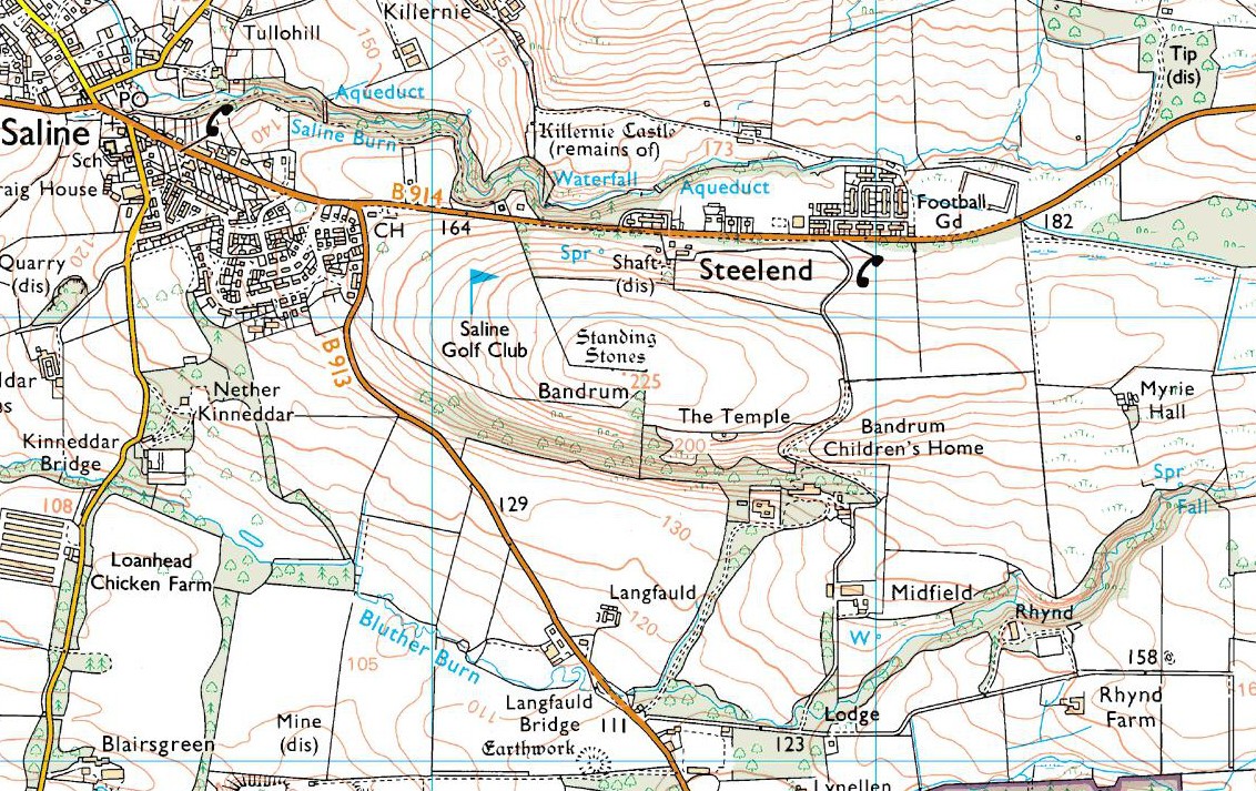
Standing Stone:  OS Grid Reference – NN 82274 16125

Also Known as:

  1. Canmore ID 25356

Getting Here

The big fella in the field

Along the A822 road between Crieff and Muthill, take the small western country lane just as you’re coming out of Muthill. Nearly 2 miles on, take the turn to the right, and then 100 yards or so from there turn sharp left. Keep along this gorgeous country lane for about a mile till you reach the third track on your left and park up.  Walk down the track and you’ll see the standingh stone in the field on your right. Go all the way to the bottom where the farm is and go through the gate into the field.

Archaeology & History

The slim end of the wedge

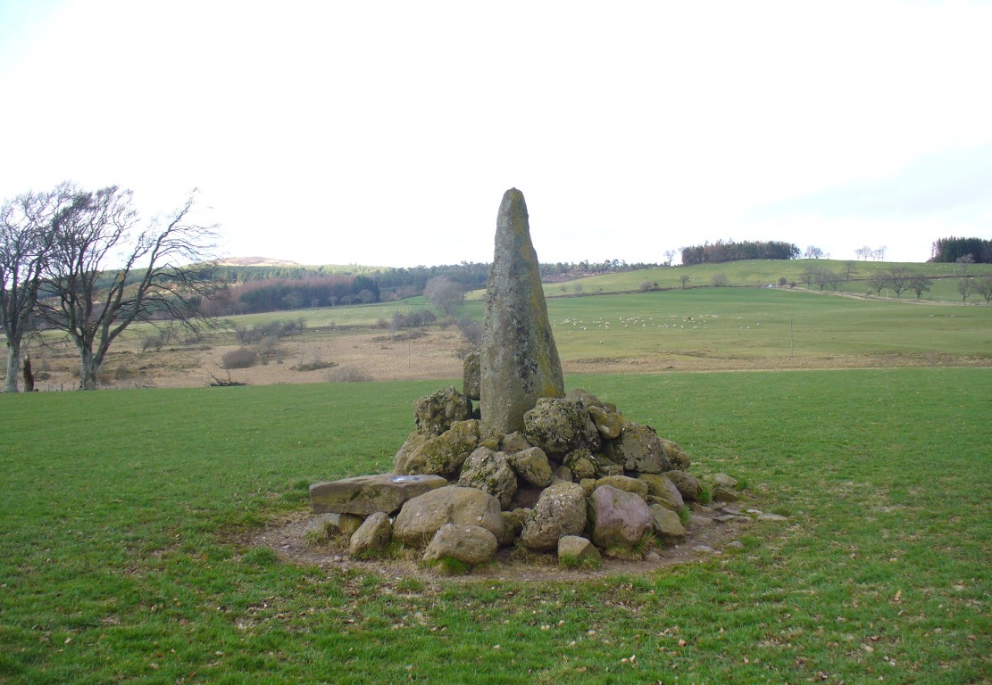
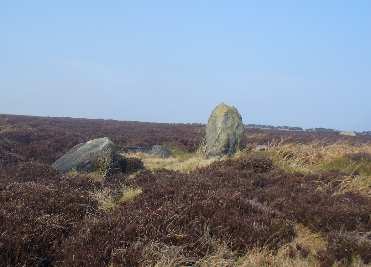
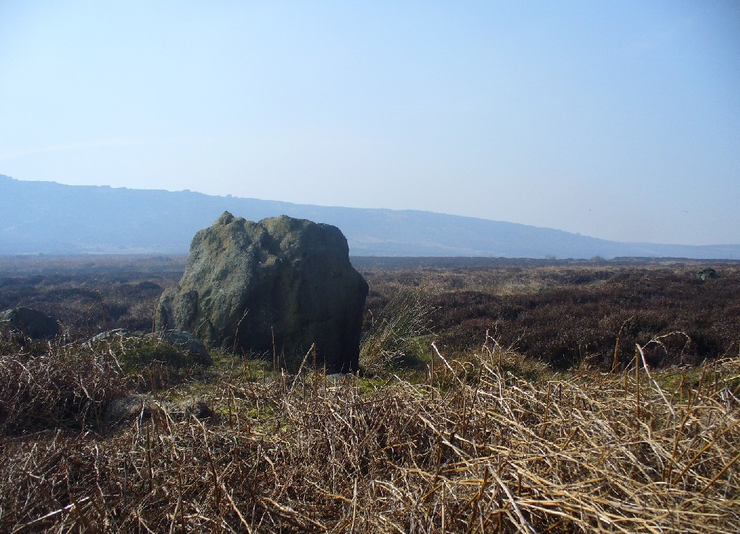
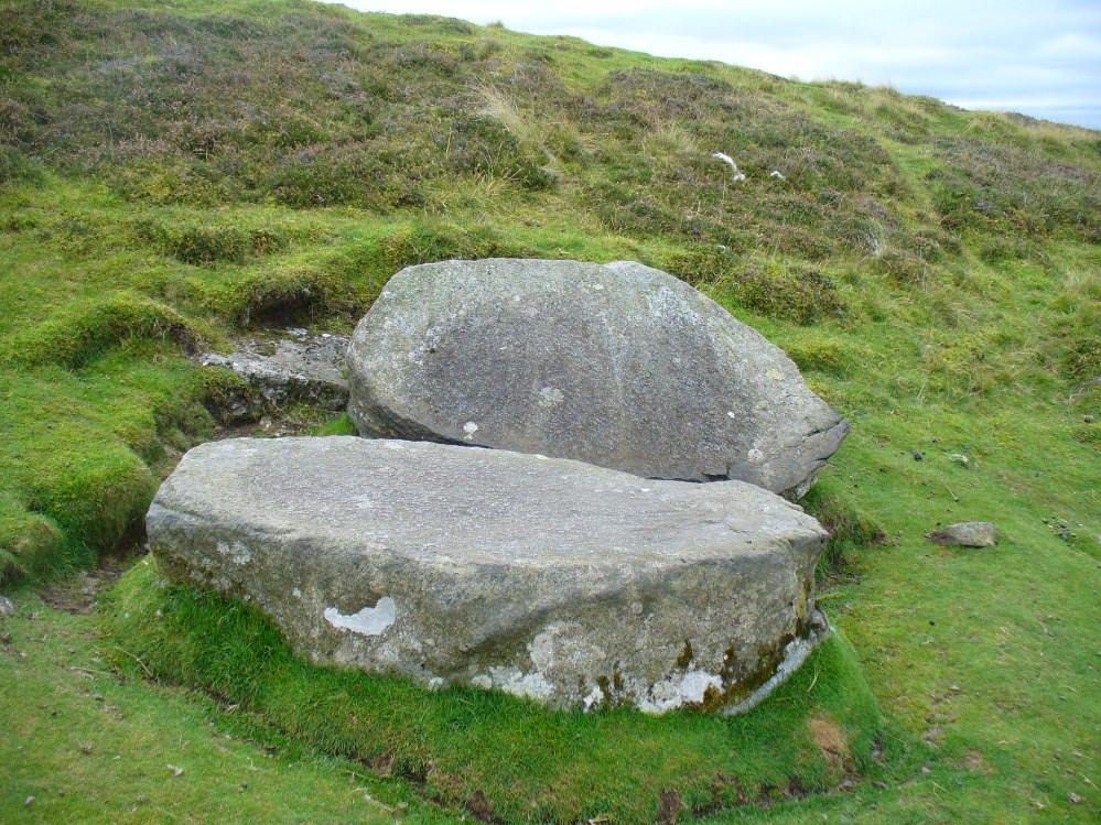
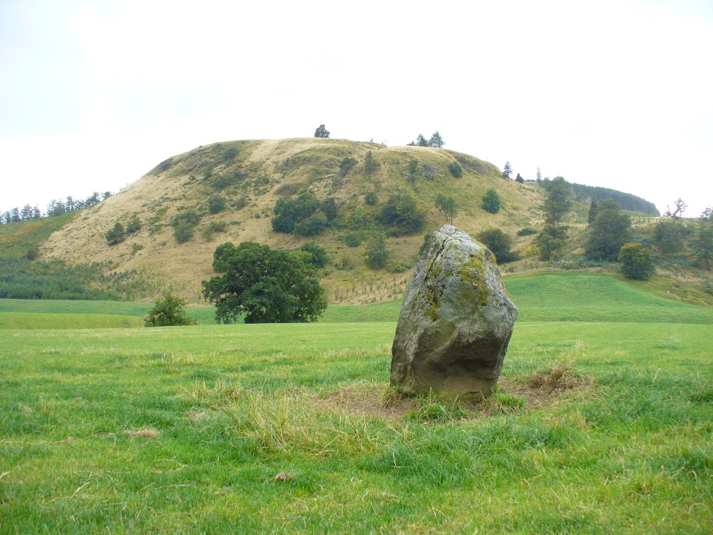
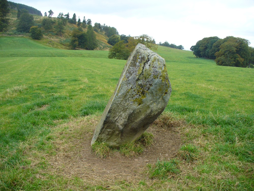
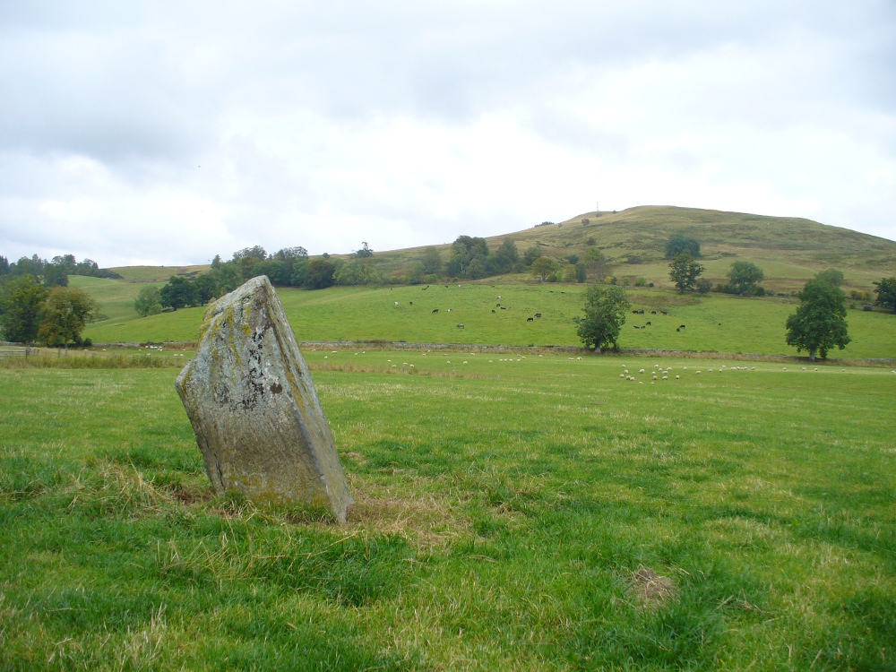
Less than 2 miles southeast of the megalithic titan of  Dunruchan A, we find a slightly smaller monolith positioned on lower ground and humbled by a more manicured landscape close to the farmhouse.  But it’s still a big fella, albeit hemmed in by a mass of field clearance rocks piled up and around the base (two of which have odd carvings on them).  The stone is about ten-feet tell, being very slim on its north-south side and much wider on its east-west face.  For some reason I got the impression that the stone wasn’t standing in its original position; though in searching through my megalith library for further information on the site, l found that very little has been written about it.  The earliest literary evidence comes, as usual, from Fred Coles (1911), who simply told us:

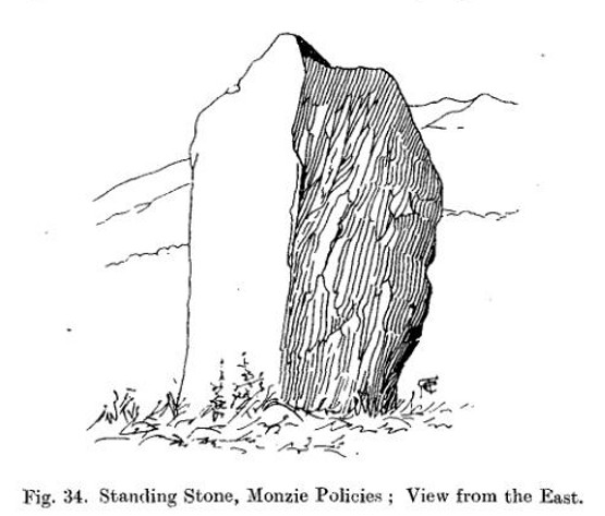
“In a field south of Machany Water and NE of Dalchirla farm-steading 260 yards, there stands this tall and striking monolith… In essential features this stone much resembles most of the great schistose blocks which characterize the main portion of the Strathearn area; but it tapers upwards to a very thin and narrow summit that rather distinguishes it from its fellows. It stands 9 feet 4 inches above ground, and girths at the base 7 feet 11 inches.  It is set with its longer axis due north and south. Around its base there are several large masses of stone—not earthfast—amid a conglomeration of smaller pieces evidently cleared off the field.”

Fred Coles' 1911 drawing
Fred Coles’ 1911 drawing

The prehistoric cairn of Torlum to the north may have had some significance to the setting of the stone, but without excavation and details of its original site, we’re just grasping at straws when it comes to evaluating any potential geomancy or landscape relationships—with the megalithic stone row in the next field perhaps being an exception!

The moorlands above here, stretching for many a mile, is apparently lacking in any prehistoric remains if you listen to the official records. But with the Dunruchan megalithic complex only two miles away and the once-giant tomb of Cairnwochel over the southeastern horizon, we know that cannot be possible… Watch this space!

References:

  1. Coles, Fred, “Report on Stone Circles Surveyed in Perthshire, Principally Strathearn” in Proceedings of the Society of Antiquaries, Scotland, volume 45, 1911.
  2. Finlayson, Andrew, The Stones of Strathearn, One Tree Island: Comrie 2010.

© Paul Bennett, The Northern Antiquarian


Cold Stone, Burley Moor, West Yorkshire

Standing Stone:  OS Grid Reference – SE 14236 45433

Getting Here

Cold Stone, looking NW

From Burley-in-Wharfedale train station, take the road uphill to the moors, turning right at the top, until you hit the bend where the stream and rocky valley of Coldstone Beck appears. Walk up the right-hand (west) side of the beck until the moorland levels out.  Walk along the footpath above Stead Crag for a coupla hundred yards, keeping your eyes peeled for the largest upright stone in the heather about 50 yards into the moors. The other way is to get to Woofa Bank Enclosure and keep walking east through the heather for a coupla hundred yards till you see the tallest upright stone in the heather.

Archaeology & History

Apart from my own short entry about this site in The Old Stones of Elmet, we have no archaeological account of this standing stone, less than four feet tall and nearly as wide at its maximum, living in a landscape renowned for its excess of neolithic and Bronze Age remains.  For those of us who love our megaliths it’s nothing special — but at the same time it’s worth looking at, if only because of the other mass of prehistoric remains close by.  It received its name from the adjacent Coldstone Beck a short distance to the east, whose etymology isn’t clear.

Cold Stone, looking east
Gazing into a hazy SW

Although we know that many of the sites on this ridge are prehistoric in origin (incredibly some of it still aint registered by those who get paid to do such things), we also need to take into consideration that this site may have been effected by the early industrialists who also made their mark on this section of the moor: they have scarred some cup-and-rings along here, destroyed other remains and left incisions on some rocks which could easily be mistaken as ancient.  There is also the possibility that this upright and its adjacent stones were once part of a cairn.   If evidence comes to light that the Cold Stone is more recent, we will of course amend this site entry.

Folklore

A number of Cold Stones are found scattered across upland Britain, in the form of crags or solitary stones.  In North Yorkshire and beyond, the name is sometimes a corruption of a Call Stone, i.e., a site where village matters were called out prior to the institution of a bell-man.  The old Market Cross in Kendal village, also known as the Cold Stone was where village notices were proclaimed.

References:

  1. Bennett, Paul, The Old Stones of Elmet, Capall Bann: Chieveley 2001.

© Paul Bennett, The Northern Antiquarian


Bandrum, Saline, Fife

Bandrum OS-mapStanding Stones:  OS Grid Reference – NT 0348 9188

Also Known as:

  1. Canmore ID 49710

Getting Here

Go east on the B913 through Saline for a mile till you reach Steelend.  Across the road from the houses there’s a dirt-track running uphill (south) into the fields.  When you’re near the top, turn west into the fields, following the straight line of fencing towards the small clump of trees on the skyline.  Near the top, a few hundred yards along you’ll see the large fat stone up against the wall.  But keep walking east and another stone appears before your eyes!

Archaeology & History

The big fella, by the gate

Near the very crown of this long hill, right by the gate separating the fields, you cannot miss this huge and very heavy-looking standing stone, whose position in the landscape was evidently of some importance to the people who put it here.  It’s in a gorgeous spot. You can see in all directions for some considerable distance particularly to the west, and the eye catches other points on the land where prehistoric monuments of other forms speak to each other. (that’s assuming you visit here on a clear bright day, as opposed to when Paul Hornby and I visited the spot when, for much of the afternoon we could barely see 100 yards as the land all around us was cloaked in fog!)

The big fella, face on
And through the fog, from the little fella to the big fella

The site was included in Alexander Thom’s (1990) magnum opus on megalithic stone rows, in which he cites it as a debatable 2-stone row monument.  For if we walk westwards, along the walling, we find another large, possibly prehistoric upright about 50 yards along.  In Aubrey Burl’s (1993) work on the same subject, he merely copies Thom’s earlier questioning of the second stone in his listings.  But in Mr Beveridge’s (1888) regional history work more than a century earlier, he told clearly that on “the ridge of the hill behind Bandrum House, there are built two standing stones.” Of their origin and purpose, Beveridge could find none; but a few years later, A.S. Cunningham (1902) thought simply that

“of the two standing stones on the march fence behind Bandrum House…it is questionable if they ever served any other purpose than a dividing line for properties.”

Bandrum Stone on 1854 map

The site was highlighted on the earliest OS-maps of the region in 1854—albeit with only the largest of the two stones marked, at the meeting of the gates—and then many decades later those other official doods, the Royal Commission (1933) lads, made their way up here and included the site in their inventory, where they told:

“On the crest of rising ground at an elevation of 700 feet above sea level, at the end of a dole near to the extreme east end of Saline golf course about a quarter of a mile due west of Bandrum farmhouse, stands a huge whinstone boulder of irregular form.  It measures 7 feet 10 inches in height to the highest point of a somewhat rounded top, and has a slight inclination towards the west.  Its girth at the base is 13 feet 7 inches and at the middle 14 feet 10 inches.  The broadest faces are to the north and south… At a distance of 162 feet due west, there is another large boulder measuring 3 feet 10 inches in height and approximately 10 feet in circumference at the middle, set with a marked inclination towards the east and built into a continuation of the same dike.  The two suggest the remains of a stone circle, the rest of which has been swept away by the cultivation of the neighbouring fields.  There is however, no record of other stones having been removed.”

Thom’s (1990) account of the site was simply put:  “Bandrum. NT 036 915. Huge whin boulder, 7ft 10 (2.4m) h. 162ft (49m) W another 3ft 10 (1.2m) h.”  He gave no indication of astroarchaeological alignments.

References:

  1. Beveridge, David, Between the Ochils and Forth, William Blackwood: Edinburgh 1888.
  2. Burl, Aubrey, From Carnac to Callanish, Yale University Press 1993.
  3. Cunningham, A.S., Romantic Culross, Torryburn, Carnock, Cairneyhill, Saline and Pitfirrane, W. Clarke: Dunfermline 1902.
  4. Royal Commission on the Ancient & Historical Monuments, Scotland, Inventory of Monuments and Constructions in the Counties of Fife, Kinross and Clackmannan, HMSO: Edinburgh 1933.
  5. Thom, A., Thom, A.S. & Burl, Aubrey, Stone Rows and Standing Stones – volume 2, BAR: Oxford 1990.

Acknowledgements: Huge thanks to Paul Hornby for his photos of these standing stones. Cheers Paul!

© Paul Bennett, The Northern Antiquarian

Split Stone, Bridge of Allan, Stirlingshire

Split Stone mapStanding Stone: OS Grid Reference – NS 81116 99311

Getting Here

Take the same directions as if you’re gonna find the Pendreich Moor cairn up the hills behind and north of Stirling University (there are 2 very close to each other).  Once upon the cairned hill, walk dead straight WNW for 100 yards or so, or down the slope into the small valley, then westwards.  You’ll hit an overgrown length of very old walling.  Keep walking along here and, below it, you’ll find these stones laying down in the shallow grasses on the south-side of the all-but dried stream.  The large Cuparlaw Wood cairn is 0.4 miles west of here.

Archaeology & History

The Split Stone, Pendreich

This is something of an anomaly.  There is no previous written history about the place (that I can find) and archaeologists and historians on The Prehistoric Society and CBA forums can offer no other explanation when asked: is this a standing stone that, many centuries ago, was cut and prepared to be erected, but never made it into the intended monument? (wherever that might have been)  And so, I offer it onto TNA and ask the same of any readers, geologists or archaeo’s who might have an explanation for this curious, large split piece of stone, that lays silently on the western moorland edges of the Ochils, asking the same question.

When I first came across this site I was simply perplexed as to the why’s and wherefore’s of who had cut such a large rock into approximate halves.  I must have walked around it many times, puzzling what the purpose would have been of doing such a thing, and how long ago the ‘split’ had been performed.  About a year later I ventured up again and, when leaving to head back into Stirling, found no resolution to my puzzlement.  It had me truly stumped!

It wasn’t until I visited the prehistoric Witches’ Stone about 15 miles away near Monzie Castle last year, that one of those ‘eureka!’ events occurred.  The last thing on my mind was the curious split rock above Bridge of Allan.  Fellow antiquarian Paul Hornby and I were taking photos of the Witches’ Stone, when one of us remarked how unusually flat and smooth one face of this upright standing stone was – in fact, incredibly flat and smooth – and that’s when it hit me! As I walked round and round the Witches’ Stone, the similarity between this upright example and the one laid on the ground about 15 miles away got stronger and stronger.

The Split Stone, looking east

A week or two later, archaeology student Lisa Samson and I went back to the Split Stone to have another look at it.  Without doubt, the appearance and size and type of rock were one and the same.  The only real difference between the Witches Stone and this Split Stone on the edge of Pendreich Moor, is that one stands upright and the other is laid down.

As you can see from the photos, we have a large rock, 5-6 feet long, which was, at some time many centuries ago, split almost straight down the middle, following a natural line of weakness or mineral deposit running through the stone.  In all probability this was a standing stone prepared and ready to be used in some neolithic or Bronze Age monument not too far way—but for some reason it never made the journey to its intended spot.

The age of this split rock needs assessing correctly by geologists.  Walking around the earthfast halves, it is difficult to see any recent evidence of mason marks that might help us determine when the rock was cut like this.  In looking at erosion marks on cut-and-dressed quarried stone from post-medieval periods, we find no equivalent scars on this Split Stone.  There is what may be faint evidence of some cuts into the stone at the top and side, but these are very debatable; and very probably it seems that the stone must have been cut a very long time ago, thousands of years back, in order to erode all obvious mason marks.  But it would be good to get a geologist to have a look and confirm or deny such things.

…And, as if this isn’t a mystery unto itself:  walk across the dried stream and go up the slope right in front of you immediately north.  There’s a small, almost level ridge you’ll reach after 30 yards up, before the hill then rises further.  If you notice, in the grasses and heather around you, there’s much more of the overgrown ‘walling’ here along this ridge—and some of it, with dips here and there and about three feet tall in places, is in a circle!  It’s man-made, it’s a ring of stones, you can see it on GoogleEarth pretty clearly, and it’s not in any official record books.

Watch this space!

© Paul Bennett, The Northern Antiquarian


Balinshoe, Kirriemuir, Angus

Standing Stone (destroyed):  OS Grid Reference – NO 4164 5219

Also Known as:

  1. Canmore ID 33871
  2. The Stannin Stane of Benshie

Archaeology & History

Site of the standing stone on 1865 OS-map
Stone on the 1865 OS-map

In a region that is full of prehistoric remains, we find here another example of another megalithic site that was sadly destroyed, not too long ago by the scale of things.  Found in association with a large prehistoric urn, we are thankful to have a couple of early local history accounts that describe the place.  The stone was obviously of some considerable height and bulk, though I can find no specific references to the dimensions of the monolith.  It was described effectively in the middle-half of the 19th century by Andrew Jervise (1853), who told us:

“‘The Stannin Stane of Benshie’, which stood for unknown ages…was demolished by gunpowder about half a century ago, and the spot is now covered by luxuriant crops of corn. This rude monument of antiquity is supposed to have been about twenty tons in weight; and at a considerable depth below it, a large clay urn, measuring about three feet in height and of corresponding circumference, was found containing a quantity of human bones and ashes.  Like its rude protector, however, the urn was broken to pieces; and, beyond the mere fact of its discovery, nothing authentic, as to either the style of its manufacture, or the precise nature or state of its contents, is preserved.”

More than 30 years later, A.J. Warden (1884) and then J.G. MacPherson (1885) all but copied Mr Jervise’s words, adding no further information.

From some reason, a small chapel dedicated to St. Ninian (NO 41567 51932) was built about 100 yards or so to the southwest of the old standing stone.  Its ruins are still to be seen. Whether this was an attempt to divert local people away from their animistic ecocentricism at the stone, into the more ecocidal egocentricism of the incoming christian cult (as was/is their common practice), we may never know for sure.

Folklore

The local name of this stone, ‘The Stannin Stane of Benshie’, indicates simply that this was “the standing stone at the hill of the faerie folk” (or variations thereof) and suggest it stood upon or next to a mound. I can find no immediate reference to stories of the little people here, and their whisper may have faded into unconscious memory.  Does anyone know more about this place?

References:

  1. Jervise, Andrew, The History and Traditions of the Land of the Lindsays in Angus and Mearns, Sutherland and Knox: Edinburgh 1853.
  2. MacPherson, J.G., Strathmore: Past and Present, S. Cowan: Perth 1885.
  3. Royal Commission on the Ancient & Historical Monuments of Scotland, The Archaeological Sites and Monuments of Central Angus, Angus District, Tayside Region, Edinburgh 1983.
  4. Warden, Alex J., Angus or Forfarshire: The Land and People – Descriptive and Historical – volume 4, Charles Alexander: Dundee 1884.

© Paul Bennett, The Northern Antiquarian


Fancarl Top, Appletreewick, North Yorkshire

Stone Circle:  OS Grid Reference – SE 06432 63048

Also Known as:

  1. Appletreewick Stone Circle

Getting Here

1st edition OS-map - the unmarked circle's near the middle
1st edition OS-map – the unmarked circle’s near the middle

Along the B6265 road between Grassington and Pateley bridge, heading east, past the hamlet of Hebden, a mile or so on where the road goes uphill, stop where it levels out a bit (before it goes further uphill to Stump Cross), a half-mile before the rocky outcrop of Nursery Knott on the left (north) side of the road.  A gate into the field on the same side is what yer after, with a small disused quarry therein.  Go up here to the quarry-top and then walk uphill for literally 100 yards and the curious small ring is right there.

Archaeology & History

Appletreewick stone circle (courtesy Paul Daw)

This small stone circle sitting on the grassy ridge overlooking the ritual rocks of Simon’s Seat and central Wharfedale to the south and the Yorkshire heathlands east and west, is probably not what it once was.  Overcome by the excess of industrial workings in the fields and moors all round here, it is probable that its present condition is far from its original state.  Indeed, if we move back to the 18th century, we find that place-name and map evidences tell us the site was a tomb.  The 1771 Greenwood map names the site as the Fancairn — an etymological curiosity in itself, possibly deriving from the ‘Windy Cairn’, which makes sense.  The place-name fell into its present title of ‘Fancarl’ after the great Ordnance Survey chaps came, heard dialect and went on their way…

The largest rock in the ring (courtesy Paul Daw)

The circle doesn’t appear to have been noted by the great Yorkshire historians Harry Speight and Edmund Bogg in their literary rambles here (rather odd), but was brought to our attention first of all (in a literary sense anyway) by Arthur Raistrick. (1965) He first “surveyed” the site in 1950, but said little until a short remark was printed in the Yorkshire Archaeological Journal, where the notes told it to be one of “two stone circles, one with clear standing stones, 30ft in diameter, and the other a double circle of small recumbent stones, 12ft in diameter.”

Ground-plan & missing stones (by Paul Daw)

The second, smaller double circle he mentions is probably a hut circle or cairn, faint traces of which are seen in the adjacent field.  Remains of a prehistoric enclosure were also once evident in the same field; and thankfully to the south (across the road) we can still find many examples of cup-and-rings at Skyreholme.

John Barnatt (1989) and Aubrey Burl (2000) include the site in their relative major surveys, with both of them citing the circle, of six small stones, to measure 8.5m by 7.5m.  The survey shown of this small stone ring was done by Paul Daw following his visit to the site on Monday 10th September 2012.

Folklore

Although we can only see six stones in this ring today, when the surveyor Paul Daw (2012) did a ground-plan of the place, he also did a dowsing survey of the site and found there were originally two extra stones on the eastern side of the circle. An archaeological dig would be interesting to see if post-holes or the remains of these two additional stones are under the turf.  He wrote:

My dowsing survey revealed that the stone circle measured 7.7 metres diameter (N-S) and 7.0 metres (E-W).  A reaction was received over the centres of stones 1, 3, 6, 7 and 8 indicating that they are still standing in their original positions, but stone number 5 to the south-south-east of the circle had a reaction at its northern end, which indicates that it was once standing but had fallen outwards. It is not therefore an earthfast stone, as speculated by A. Raistrick, when he visited the site.  The stone measures 1.65 m x 1.65 m x 800 mm and fans out like a shell from bottom to top. It would have been an impressive stone when standing, but was top heavy, and the most likely stone to fall.

Stones 1, 3, 6, and 8 are all of a similar size, are much more stable, and stand at about 500 mm high.  Stone 7 in the western sector is 800 mm high, and measures 950 mm x 850 mm, and looks like a rectangular block, with slightly rounded edges.

I also obtained a reaction at positions 2 and 4, indicating that there were once stones standing in these positions. To the north of the stone circle there are a number of stones lying on the surface.  A. Raistrick suggested that there may have been another small stone circle in this area, but my dowsing rods did not detect anything, and it is probable that these are random stones lying on the surface.

This entire region is bedevilled with faerie, goblin and giant lore, plus creation myths of our peasant ancestors (Sutcliffe 1929) — some still living if you’re lucky enough to talk with the old folk, who might tell you a thing or two, or might not, depending on how you smell.

References:

  1. Barnatt, John, The Stone Circles of Britain – 2 volumes, BAR: Oxford 1989.
  2. Burl, Aubrey, The Stone Circles of Britain, Ireland and Brittany, Yale University Press 2000.
  3. Daw, Paul M., “Appletreewick Stone Circle, Yorkshire Dales,” unpublished survey report 2012.
  4. Raistrick, Arthur, ‘Yorkshire Archaeological Register 1964: Appletreewick, W.R.,’ in Yorkshire Archaeology Journal, volume 41, 1965.
  5. Smith, A.H., The Place-Names of the West Riding of Yorkshire – volume 6, Cambridge University Press 1963.
  6. Sutcliffe, Halliwell, The Striding Dales, Frederick Warne: London 1929.

AcknowledgementsHuge thanks to Paul Daw for his photos and survey of the site, and for sharing details of his dowsing results here.

© Paul Bennett, The Northern Antiquarian


Ring Stones Hill, Catlow, Nelson, Lancashire

Stone Circle (destroyed?):  OS Grid Reference – SD 892 367

Archaeology & History

Set in good landscape with fine views in most directions, it seems that the only thing that remains of this site is a place-name on a map—but I have to say that our search here was only a short one, and so more may be found hiding away in field walls or beneath the ground.  However, if we listen to an early account of the place, it was said to have “completely gone by 1856.”  A pity, as it was described as being “a large circle of stones.”  The monument was used for repairing the nearby road and, in another account, we are told that the stones were added to the walls.  Whether this was a cairn circle or a free standing stone circle isn’t known.  The prevalence of tumuli close by at Catlow, Burwains, etc, would suggest a cairn circle, yet we have no accounts of human remains here… A puzzle.

References:

  1. Barnes, Bernard, Man and the Changing Landscape, Liverpool University 1982.

© Paul Bennett, The Northern Antiquarian


Calverley Woods Stone Circle, Leeds, West Yorkshire

Stone Circle:  OS Grid Reference — SE 20 37

Archaeology & History

Having lived close to these woods in the past, I have searched extensively for any remains of the stone circle described by a Miss Alice Wells in the very first issue of the Cartwright Hall Archaeology Group Bulletin, but to no avail.  A meeting to examine this site was supposed to have taken place in September 1953, “but as Miss Wells was unavoidably absent this was not seen.”  And still to this day it remains hidden [or non-existent, whatever the case may be].  There is ample evidence that prehistoric man roamed this region, as finds of cup-and-ring stones and iron age walling indicate.  A possible contender for this stone circle could be the small ring of rocks seen near the bottom of the wooded hill beneath the giant Hanging Stone, close to grid reference SE 2003 3748.  About 10 yards across, this looked like a smaller version of the Roms Law circle several miles west, but is much overgrown and not visible beneath the undergrowth of summer vegetation.

The presence of prehistoric cup-marked stones in this woodland clearly indicates Bronze Age activity here and—as such petroglyphs have a tendency in West Yorkshire to be associated with tombs and death in many cases—may indicate the lost site was indeed a cairn circle and not a true stone circle. Seems likely to me. If anyone has any photos of this site, or can ascertain its exact whereabouts, please let us know and all credits will be given for its rediscovery.

References:

  1. Bennett, Paul, The Old Stones of Elmet, Capall Bann: Milverton 2001.
  2. Jackson, Sidney (ed.), “Calverley Wood,”in Cartwright Hall Archaeology Group Bulletin, 1:1, July 1954.

© Paul Bennett, The Northern Antiquarian


Dunmoid, Dalginross, Comrie, Perthshire

Stone Circle:  OS Grid Reference – NN 78030 21266

Dunmoid Circle, Comrie

Also Known as:

  1. Canmore ID 24857
  2. The Court Knoll
  3. Dalginross
  4. Dunmhoid
  5. Judgement Mound
  6. Muirend
  7. Roundel

Getting Here

From the main road running through lovely Comrie, take the south B827 road over the old river bridge.  Go dead straight for several hundred yards until the road bends right; but take the left turn here.  100 yards or so along note the trees on your right, and the road begins to swerve round here. Just round the corner in the trees, the stones are in the clearing right by the roadside. You can’t miss them! (if you hit the graveyard, you’ve gone past them)

Archaeology & History

This is a truly lovely, almost warming enclosed megalithic site—albeit damaged by the ruin of centuries; but on the occasions I’ve been here it feels quite nurturing and elicits a quite natural meditative state.  Whether or not this is due to the surround of trees, or the natural electromagnetic field, or just me, I dunno….

Dunmoid Circle, looking SE
Dunmoid from the North (Coles 1911)

The ‘circle’ is constructed upon a flat rounded section of ground, surrounded by a ditch on two-thirds of its edges, very reminiscent of a typical henge monument—but there is no mention of this in modern surveys.  One of the earliest accounts of Dunmoid was written by John MacPherson (1896) who gave us as much of the known history of the site as is still known by any modern academic.  He wrote:

“At the west side of the new cemetery, close to the public road, there is a curious round knoll, which at one time must have been used as a place for the burial of the dead.  The attention of the writer of this was drawn to it about twenty years ago.  There were three large slabs of stone lying upon the ground, which apparently had been at some former period placed erect by some loving hands to mark the last resting-place of some departed friend or hero.  By the aid of some of the Comrie masons the stones were placed in a standing position.  Curious to know what lay beneath the surface, we dug up the earth in front of the largest slab, and came upon a stone cist placed north and south, 7 inches long, 1 foot 8 inches broad, and 1 foot 3 inches deep.  The only remains discovered was a thigh-bone, but whether it at one time formed a part of the leg of a Celt, a Roman, or a Saxon we could not tell. An old man who then lived in the village of Comrie told us that in his young days the same mound was dug up, when an urn filled with ashes was discovered.  This, perhaps, would indicate that it formed a place of burial for Romans rather than for Caledonians.  The spot is called Dunmoid, or ‘hill of judgment.'”

Fred Coles 1991 plan
Dunmoid from SE (Coles 1911)

The circle gained the attention of the prolific Fred Coles (1911) in his Perthshire surveys, whose drawings and measurements are still repeated in the modern textbooks more than a century later.  When he visited the site, two of the stones were still upright, but today only one still stands.  In Aubrey Burl’s (1988) survey on ‘four-poster’ stone circles, he reiterated Coles’ words, telling:

“Originally four stone stood at the corners of a rectangle on a mound some 75ft (23m) across and 2ft (60cm) high.  Coles’ plan showed the NW stone standing 5ft 4ins (1.6m) high and the SE, opposite, 5ft 2ins (1.6m), with the thick NW stone prostrate, 4ft 6ins (1.4m) long, with the more slender SW pillar also supine and 4ft (1.2m) long.  The longer SE and NW sides of the oblong were roughly 9ft 6ins (2.9m) long and the others 9ft (2.7m) in length.  The circle on which the stones had been placed had a diameter 13ft 2ins (4m), of which the Megalithic Yard is not an integer.”

The circle is included in Andrew Finlayson’s (2010) modern survey of the region.

References:

  1. Burl, Aubrey, Four Posters: Bronze Age Stone Circles of Western Europe, BAR 195: Oxford 1988.
  2. Finlayson, Andrew, The Stones of Strathearn, One Tree Island: Comrie 2010.
  3. Hunter, John (Ed.), Chronicles of Strathearn, David Philips: Crieff 1896.
  4. Hutchison, A.F., “The Standing Stones of Stirling District,” in The Stirling Antiquary, volume 1, 1893.
  5. MacPherson, John, “At the Head of Strathearn,” in Chronicles of Strathearn, Crieff 1896.

© Paul Bennett, The Northern Antiquarian


Witches Stone, Monzie, Crieff, Perthshire

Standing Stone:  OS Grid Reference – NN 87980 24321

Also Known as:

  1. Canmore ID 25448
  2. The Witches Stone & her crags to the rear
    The Witches Stone & her crags to the rear

    Kor Stone

Getting Here

Along the A822 road past Crieff and then Gilmerton, shortly past here is a small road to Monzie and the Glenturret Distillery or Famous Grouse Experience. Go on this road and after a just a coupla hundred yards you’ll see the large old gatehouse for Monzie Castle on the left. Ask at the gatehouse and they’ll point you to the stone—in the field about 300 yards past the Monzie stone circle, 200 yards past the gatehouse itself.  You can’t really miss it!

Archaeology & History

The southern flat face of the Witches Stone

This is a fascinating stone for a variety of reasons—not least of which it enabled us to identify an otherwise curious geological anomaly as an unerected standing stone some 16 miles SSW…but that’s a story for later!  The stone here leans at an angle in the field, as shown in the photo, but it still rises 5 feet tall and is a thick chunky fella, with one face very flat and smoothed indeed from top to bottom.  This side of the stone was obviously cut and dressed this way when first erected.  As Paul Hornby then noted, its western face is also quite flat and smoothed aswell, with the edge between the two sides almost squared at right-angles.  The eastern and southern sides of the stone are undressed, as the phrase goes.  These physical characteristics have just been found at a newly found pair of un-erected standing stones on the western edges of the Ochils, just below a newly found cairn circle.

Fred Coles 1911 drawing
Witches Stone, looking NE past Milquhanzie Hill fort

There were several early descriptions of this stone, two of which talked about an avenue or road along which the stone seemed to stand within.  This ‘avenue’ was in fact the very edge of what is probably an earlier prehistoric enclosure—but you can’t really see this anymore unless you’re in the air (check Google Earth, which shows it reasonably well).

In J. Romilly Allen’s (1882) account, he mentions the stone only in passing, telling it to be “a single standing stone measuring 4 feet by 3 feet and 5 feet high (with) no markings on it.”  It was later described in Fred Coles’ (1911) survey of the region where he told:

“This monolith is the westerly of the two prehistoric sites grouped on the O.M. as Standing Stones. It stands a few yards to the south of the avenue, almost half a mile from the East Lodge. The Stone has a slight lean towards the north. Its southern side is remarkably broad and smooth, measuring 4 feet across the base on that side, in girth 13 feet 1 inch and in vertical height 4 feet 9 inches.”

Alignment to Monzie stone circle, just visible in field

In Alexander Thom’s edited magnum opus (1980) he found that this standing stone—800 feet northwest of the superb Monzie cup-and-ring stone and associated megalithic ring—marks the midsummer sunset from the stone circle. We noted on our visit here, that this alignment runs to the distant cairn on the far northwest horizon, many miles away.

Folklore

In Joyce Miller’s (2010) excellent work on Scottish heathenism, she told the folowing tale of this stone:

“The standing stone is said to mark the site of Kate McNiven or MacNieven’s, sometimes known as the witch of Monzie, execution. The story goes that she was put in a barrel and rolled down what is now known as Kate MacNieven’s Craig on the north side of the Knock of Crieff before being burnt.  Kate had been the nurse to the Grahams of Inchbrackie, and was accused of witchcraft, including turning herself into a bee.  Graham of Inchbrackie tried to save her but to no avail, but as she was about to die it is said that she spat a bead from her necklace into his hand. The bead – a blue sapphire – was turned into a ring and it was believed that the ring would keep the family and lands secure.  She did, however, curse the laird of Monzie, although whether this worked or not is not known. MacNiven or Nic Niven was also believed to be the name of the Queen of Fairies.  Indeed it is not clear whether Kate MacNiven was a real person or is a conflation of stories. There do not appear to be any contemporary records of her execution at or near Crieff, and dates for her unpleasant death are variously given as 1563, 1615 and 1715.”

…to be continued…

References:

  1. Allen, J. Romilly, “Notes on some Undescribed Stones with Cup Markings in Scotland,” in Proceedings of the Society of Antiquaries Scotland, volume 16, 1882.
  2. Coles, F.R., “Report on stone circles in Perthshire principally Strathearn,” in Proceedings of the Society of Antiquaries, Scotland, volume 45, 1911.
  3. Finlayson, Andrew, The Stones of Strathearn, One Tree Island: Comrie 2010.
  4. Holder, Geoff, The Guide to Mysterious Perthshire, History Press 2006.
  5. Marshall, William, Historic Scenes in Perthshire, Oliphant: Edinburgh 1881.
  6. Miller, Joyce, Magic and Witchcraft in Scotland, Goblinshead 2010.
  7. Thom, Alexander, “Megalithic Astronomy: Indications in Standing Stones,” in Vistas in Astronomy, volume 7, 1966.
  8. Thom, A., Thom, A.S. & Burl, H.A.W., Megalithic Rings, BAR: Oxford 1980.
  9. Watson, David, A Simple Introduction to the Stone Circles and Standing Stones of Perthshire, 2006.

© Paul Bennett, The Northern Antiquarian