 Standing Stones: OS Grid Reference – NT 0348 9188
Also Known as:
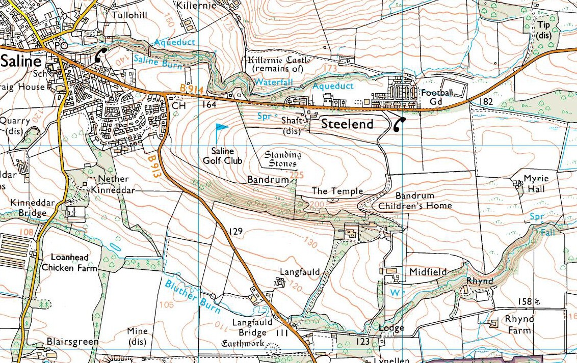
Go east on the B913 through Saline for a mile till you reach Steelend. Across the road from the houses there’s a dirt-track running uphill (south) into the fields. When you’re near the top, turn west into the fields, following the straight line of fencing towards the small clump of trees on the skyline. Near the top, a few hundred yards along you’ll see the large fat stone up against the wall. But keep walking east and another stone appears before your eyes!
Archaeology & History

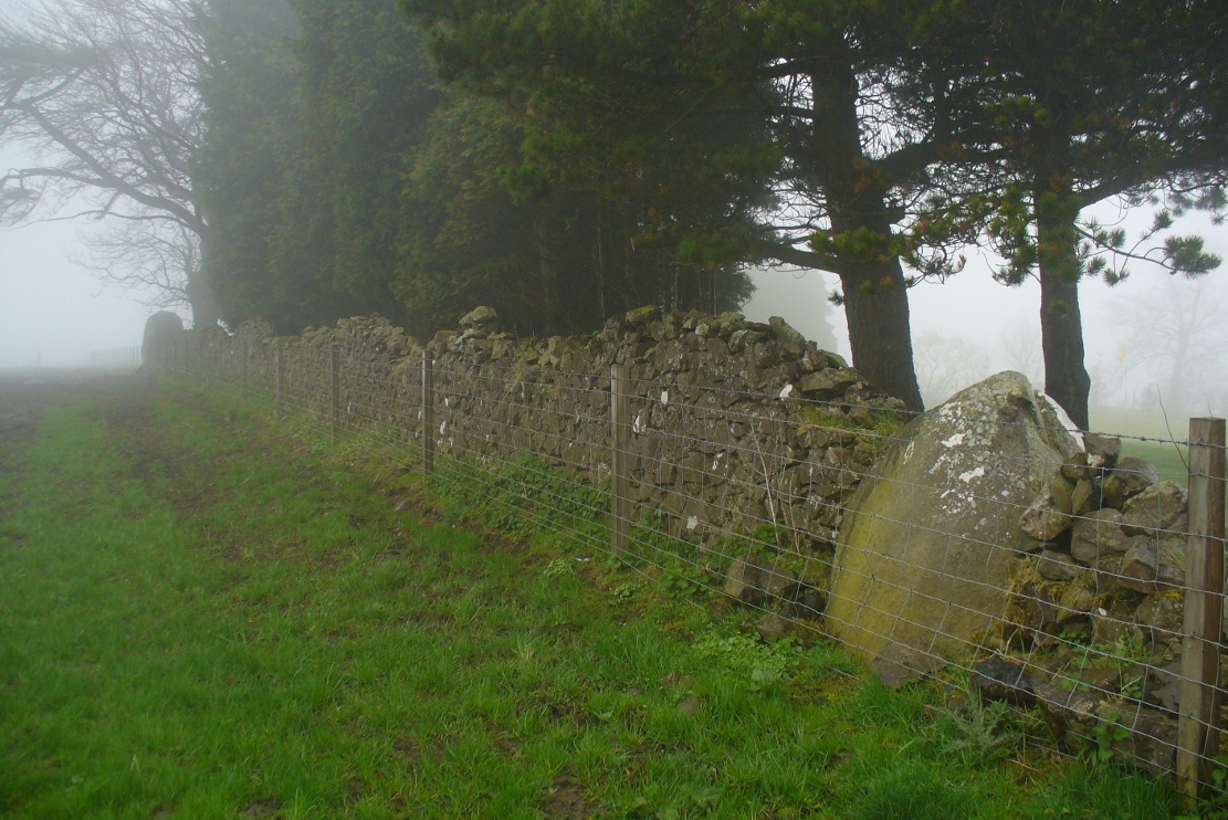
Near the very crown of this long hill, right by the gate separating the fields, you cannot miss this huge and very heavy-looking standing stone, whose position in the landscape was evidently of some importance to the people who put it here. It’s in a gorgeous spot. You can see in all directions for some considerable distance particularly to the west, and the eye catches other points on the land where prehistoric monuments of other forms speak to each other. (that’s assuming you visit here on a clear bright day, as opposed to when Paul Hornby and I visited the spot when, for much of the afternoon we could barely see 100 yards as the land all around us was cloaked in fog!)

The site was included in Alexander Thom’s (1990) magnum opus on megalithic stone rows, in which he cites it as a debatable 2-stone row monument. For if we walk westwards, along the walling, we find another large, possibly prehistoric upright about 50 yards along. In Aubrey Burl’s (1993) work on the same subject, he merely copies Thom’s earlier questioning of the second stone in his listings. But in Mr Beveridge’s (1888) regional history work more than a century earlier, he told clearly that on “the ridge of the hill behind Bandrum House, there are built two standing stones.” Of their origin and purpose, Beveridge could find none; but a few years later, A.S. Cunningham (1902) thought simply that
“of the two standing stones on the march fence behind Bandrum House…it is questionable if they ever served any other purpose than a dividing line for properties.”
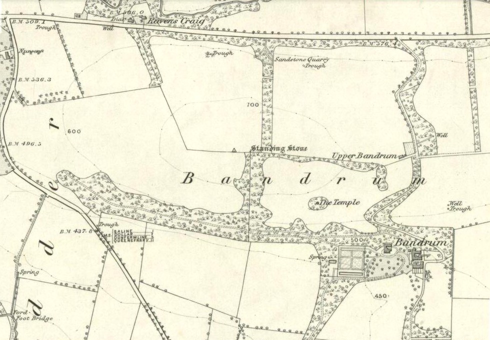
The site was highlighted on the earliest OS-maps of the region in 1854—albeit with only the largest of the two stones marked, at the meeting of the gates—and then many decades later those other official doods, the Royal Commission (1933) lads, made their way up here and included the site in their inventory, where they told:
“On the crest of rising ground at an elevation of 700 feet above sea level, at the end of a dole near to the extreme east end of Saline golf course about a quarter of a mile due west of Bandrum farmhouse, stands a huge whinstone boulder of irregular form. It measures 7 feet 10 inches in height to the highest point of a somewhat rounded top, and has a slight inclination towards the west. Its girth at the base is 13 feet 7 inches and at the middle 14 feet 10 inches. The broadest faces are to the north and south… At a distance of 162 feet due west, there is another large boulder measuring 3 feet 10 inches in height and approximately 10 feet in circumference at the middle, set with a marked inclination towards the east and built into a continuation of the same dike. The two suggest the remains of a stone circle, the rest of which has been swept away by the cultivation of the neighbouring fields. There is however, no record of other stones having been removed.”
Thom’s (1990) account of the site was simply put: “Bandrum. NT 036 915. Huge whin boulder, 7ft 10 (2.4m) h. 162ft (49m) W another 3ft 10 (1.2m) h.” He gave no indication of astroarchaeological alignments.
References:
- Beveridge, David, Between the Ochils and Forth, William Blackwood: Edinburgh 1888.
- Burl, Aubrey, From Carnac to Callanish, Yale University Press 1993.
- Cunningham, A.S., Romantic Culross, Torryburn, Carnock, Cairneyhill, Saline and Pitfirrane, W. Clarke: Dunfermline 1902.
- Royal Commission on the Ancient & Historical Monuments, Scotland, Inventory of Monuments and Constructions in the Counties of Fife, Kinross and Clackmannan, HMSO: Edinburgh 1933.
- Thom, A., Thom, A.S. & Burl, Aubrey, Stone Rows and Standing Stones – volume 2, BAR: Oxford 1990.
Acknowledgements: Huge thanks to Paul Hornby for his photos of these standing stones. Cheers Paul!
© Paul Bennett, The Northern Antiquarian