Mike Short tells: Walk ENE along Thornhill Drive (no vehicular access) to gate across road at the last house on the Drive and continue on for approx 475m where road starts to narrow slightly, becomes a little steeper and gently turns to E. Thornhill Drive is now cut into the hillside at this point with an upwards sloping bank on the S side of the path. After approx 25m further on at approx SE 20375 37950 look out on the S side of the path for a pile of boulders sitting on bedrock on top of the bank and a large rectangular tabular rock on the side of the bank. Ascend the bank and from the boulder pile the panel is approx 22m 200º(T) in the middle of an ephemeral E-W path more defined to W.
Archaeology & History
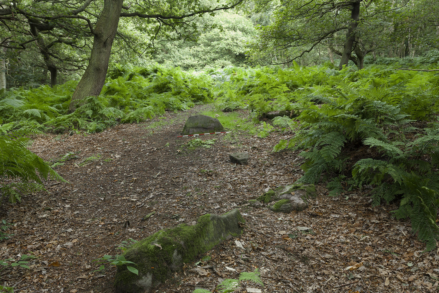
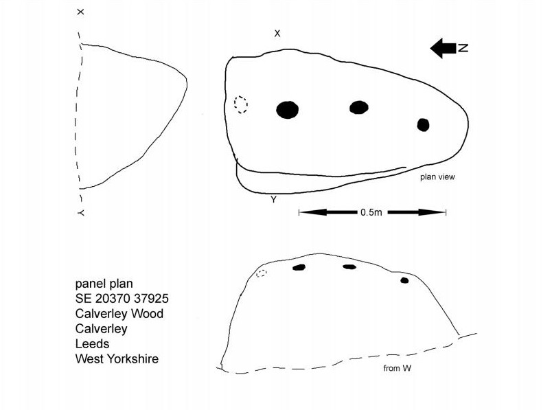
The profile (and ‘How to Get There’) for this recently discovered cup-marked stone was forwarded to me by fellow rock art explorer, Mike Short. The carving is another basic design found in Calverley Woods, between Leeds and Bradford, nearly halfway between the missing petroglyphs of West Woods 2 and Sidney Jackson’s Calverley Woods Stone. Rediscovered by Lisa Volichenko some time ago, Mike described the new carving here as follows:
Sketch of the carving (courtesy Mike Short)Cup-Marked Stone nr centre (courtesy Mike Short)
“Panel is carved on W sloping face of a sub-triangular earthfast coarse-grained sandstone boulder 0.81m X 0.50m X 0.38m, the longest axis lying almost exactly N-S. Carving consists of 3 cups, the most N of which is elliptical approx 65mm X 55mm; the central cup is elliptical approx 50mm X 40mm and the most S is circular diameter approx 40mm. On the N edge of the W face is a shallow elliptical depression thought to be of natural origin. There is an area of damage along the ‘crest’ of the boulder close to its S end.
“Carved rock is the most E of five rocks, measuring between 0.70m and 1.15m in length, in very close proximity forming an arc, 3 of which are in the footpath and one of which is resting on a large slab of rock almost completely covered by soil and vegetation.”
And so the small number of cup-marked stones in this woodland slowly grows. One wonders how many more are hidden beneath the roots of the trees—and are all of the lines and cups atop of the great Hanging Stone, a short distant away, all Nature’s handiwork…?
Acknowledgements: Huge thanks for Mike Short for the data, photos and sketch of this carving.
Although now seemingly lost, it’s location is damn close to this: Along the A657 between Greengates and Bradford, where the New Line meets Carr Road, the dirt-track takes you into Calverley Woods, down Eleanor Drive. About 250 yards along (just before you get to the field on the left), take the footpath down the embankment towards the stream where it bends to the left and where the land levels out (don’t cross the stream). It’s somewhere round there!
Archaeology & History
This was one of two previously unrecognised carvings we came across sometime in 1985 (see West Woods 1 stone), when we were seeking out another missing carving in the same woods. It was clear and well-defined as the faded photo here shows; but having been back to try find it twice in the last two years in the hope of getting better photos, I’ve been unable to locate it. The carving was described in an article I did in an old earth mysteries magazine. It comprises simply of a large ring surrounding and enclosing two deep cups, which were linked to each other by a connecting carved line. Parts of the stone had been chipped in parts—including a section of the large ring— due to some industrial workings that had happened here in the past. Thankfully I managed to find the old photo and hopefully, perhaps, some local explorer could try and seek out where it’s hiding beneath the trees and other vegetation.
References:
Bennett, Paul, “The Undiscovered Old Stones of Calverley Woods,” in Earth no.2, 1986.
Settlement (destroyed): OS Grid Reference – SE 309 336
Archaeology & History
Absolutely nothing is left of the large series of ancient earthworks that were reported to have existed near the very centre of Leeds by Ralph Thoresby, James Wardell and others in the 18th and 19th centuries. Although we do not know with certainty the age and nature of the site, it would seem very likely to have had a prehistoric provenance. However, this wasn’t the opinion of either Thoresby (1715) or Thomas Whitaker (1816). They both thought the remains were of Roman origin – but we must remind ourselves of the inaccuracies made, particularly by Whitaker, when it came to estimating the dates of early monuments (e.g., Whitaker’s assertions of the huge Counter Hill earthworks above Addingham). Sometime later, James Wardell (1853) thought the remains on Quarry Hill were distinctly pre-Roman; though reasoned that the invading force may have used the site at a later date. Wardell wrote:
“Traces of a prior occupation were, until recently, observable on the summit of Quarry-hill, along the western edge of which ran an earthwork of considerable length and magnitude, and of semi-circular form.”
We know little else of the place, sadly, but the shape of the site around the hilltop edges would seem to support the likelihood of an Iron or Bronze Age origin. Further information would, of course, be more helpful…
References:
Thoresby, Ralph, Ducatus Leodiensis, Maurice Atkins: London 1715.
Wardell, James, The Antiquities of the Borough of Leeds, Moxon & Walker: Leeds 1853.
Whitaker, Thomas D., Loidis and Elmete, T. Davison: Leeds 1816.
Tumulus (destroyed): OS Grid Reference – SE 302 337
Archaeology & History
Remains from Briggate’s tomb
We don’t know for sure whether the burial site that once stood near Leeds city centre was a cairn, a tumulus, or just a stone-lined cist (stone grave), but due to the prevalence of similar prehistoric sites in the neighbourhood, it’s most likely to have been a small tumulus that once existed here. All trace of it has obviously gone. The most detailed reference we have of this place was the account given by the 19th century Leeds historian, James Wardell (1853), who thankfully gave us the drawing of remains found within the tomb and who wrote:
“In the year 1745, a most interesting discovery occurred, of an urn containing ashes, calcined bones, and a stone axe perforated for a shaft, which were found by a carpenter at a depth of about two feet, on sinking a tenter post, in a field near to the top of Briggate, in Leeds. The urn was of rude formation, imperfectly baked, and ornamented after the usual maimer of the Britons, with encircling rows of indentations; it measured about twelve inches in height, and was placed with its mouth upwards, having a cover, wliieh was broken by the workman. The whole of these artielt^s were taken pos- session of by Mr. Alderman Denison, the owner of the field, who resided near ; their subsequent fate is unknown, and their loss as a local one is to be deplored; but fortunately small sketches of them were made at the time, which has enabled me to give the drawings contained in Plate I. These relics lay claim to an earlier date…and have appertained to some warrior of the prehistoric period, whose simple, yet solemn funeral rites, were here performed, and in memory of whom the cairn, or the barrow was raised.”
There is a remote possibility that the position of St. John’s Church, a short distance north of Briggate, may have had some relationship with this sacred burial site. St. John was the christian church’s midsummer saint.
References:
Wardell, James, The Antiquities of the Borough of Leeds, John Russell Smith: London 1853.
On the A657 road, a half-mile past Greengates towards Calverley, just before the road starts going uphill, take the lower dirt-track of Eleanor Drive on your left into Calverley Woods (here known as West Woods). About 150 yards along the track, note the small footpath on the right which goes up diagonally further into the trees. Go along here until you reach the remains of a dried-up pond on your left. The carved stone is about 10 yards before the pond, just above the footpath.
Archaeology & History
Rubbing of the 2 cupmarks
Another stone only for the puritans amongst you! This (and the West Woods 2 carving) was one we found in 1985 when we were exploring the woods looking for the Calverley Woods cup-marked stone reported by Sid Jackson in the 1950s. The stone is a small roughly oblong, earthfast rock, about 2ft by 1ft across, and has two distinct but faded cup-marks on its slightly sloping face. That’s it!
Soon after first finding this, we made a couple or rubbings of the stone, one of which I reproduce here and which shows the two cup-marks. You’ll note the measurement and note of the cups being 2 megalithic inches (MI) in diameter. The MI was a statistical unit of measure suggested by the late great Alexander Thom, who found regular integers of 2.07cm in many of the cup-and-rings he examined, and so surmised it as a deliberate numeric system. At the time when we found this cup-marked stone, I was exploring Thom’s idea and was very much taken up with it. However, after a few years doings numerous rubbings of the many cup-and-ring stones in West Yorkshire, and exploring the simple size of the human hand and how we execute cup-markings on rocks, I found Thom’s idea didn’t seem to be realistic. (though I still love Thom’s works: the man was an outstanding researcher, far exceeding all the archaeologists of his period in terms of his exploratory methods)
References:
Bennett, Paul, “The Undiscovered Old Stones of Calverley Woods,” in Earth 2, 1986.
Standing Stone (destroyed?): OS Grid Reference – SE 282 402
Archaeology & History
Idol Rock, Adel (Simpson 1879)
Difficult to know what to think about this one. It seems to have been described just once in the latter half of the 19th century by that real Bible-thumping nutcase, Henry Simpson (1879), who gave us the only known picture of the place. Simpson said that it was, “the remains of supposed Idol Rock on the moor near Adel reformatory, under the Alwoodley Crags. About six foot high.” It is believed to have been destroyed, but having not checked the region thoroughly, it could still be there somewhere (the grid reference cited here is an approximation). Does anyone know owt else about it?
References:
Simpson, Henry T., Archaeologia Adelensis, W.H. Allen: London 1879.
Standing Stone (destroyed?): OS Grid Reference – SE 2501 4119
Also Known as:
Long Stoop
Archaeology & History
Sadly gone, this looked to be one helluvan impressive standing stone. Described just once by the christian fruitbat Henry Simpson (1879), who told us:
“In a hedge-row, or rather stone row…is a remarkable, ancient monolith, it is thirteen feet in height; from its slender character, it does not appear to have formed one of a trilithon, but rather to have constituted a memorial of some sort, or as a beacon of some usefulness. I can discover no barrow or earthwork near the spot. There are remnants of a quarry close by, with a mound of earth arising therefrom, but no indications to give a clue to the meaning or use of this single pillar. It is composed, moreover, of millstone grit, which is not to be found in the immediate neighbourhood, so it must have been brought from a distance and placed in its present position.
“Some suppose this to be a Roman stoup or pillar, designed for a landmark; but it bears no mark of Roman worksmanship. It is crude in the extreme.”
Simpson’s 1879 drawing
There is no available folklore known to the Long Stoop, although a long straight path terminated where the monolith stood. This path was one of many in an intricate geometric lay-out of perfect circular and dead straight tracks in the woodland immediately south of here [now built over], with four-, eight- and twelve-fold lines intersecting each other over a very large area. It may be that this large, seemingly lost standing stone, could have been a part of the ornate grounds that were laid out here in bygone centuries, perhaps erected by the architects behind the project.
It would be damn good if locals in and around Adel could relocate this monolith — which is as likely propping up some old walling somewhere nearby — so we can make a healthy assessment as to its authenticity. Are there any Leeds pagans who might be able to rediscover this lost standing stone?
References:
Bennett, Paul, The Old Stones of Elmet, Capall Bann: Milverton 2001.
Simpson, Henry Trail, Archaeologia Adelensis; or a History of the Parish of Adel, W.H. Allen: London 1879.
Holy Well (destroyed): OS Grid Reference – SE 295 329
Archaeology & History
In the Holbeck area of Leeds, one of the three spa wells was previously patronised to this mythical saint, whose wells profuse in this part of the world. St. Helen’s Well (later becoming the Holbeck Spa Well) was found at the appropriately named St. Helens Bridge. Ralph Thoresby (1715) wrote of the place: a supposed medicinal holy well, it previously had a chapel by it, of which no trace is seen today. John Mayhall (1860) also mentioned this “medicinal well,” but told little more. It was Andrea Smith (1982), more than a century later, who wrote the most about the place:
“In connection with the well by St.Helen’s Bridge, Holbeck, (Thoresby) refers to “another ancient fabrik called St. Helen’s,” but there is a difficulty in deciding exactly what he means by ancient; it is taken here as meaning more than two hundred years old. This suggests, then, that by St. Helen’s Bridge there was once a well and chapel which gave rise to the dedication and which was probably a Medieval foundation, considering the popularity of St. Helen at that time.”
Both of these sites have long since disappeared. The well eventually became known as a local Spa Well, and was found to possess a high sulphur content.
References:
Mayhall, John, The Annals of Yorkshire, Joseph Johnson: Leeds 1860.
Smith, Andrea, ‘Holy Wells Around Leeds, Bradford & Pontefract,’ in Wakefield Historical Journal 9, 1982.
Thoresby, Ralph, Ducatus Leodiensis: or the Topography of the Ancient and Populous Town and Parish of Leedes, Robinson & Holdsworth: Leeds 1816.
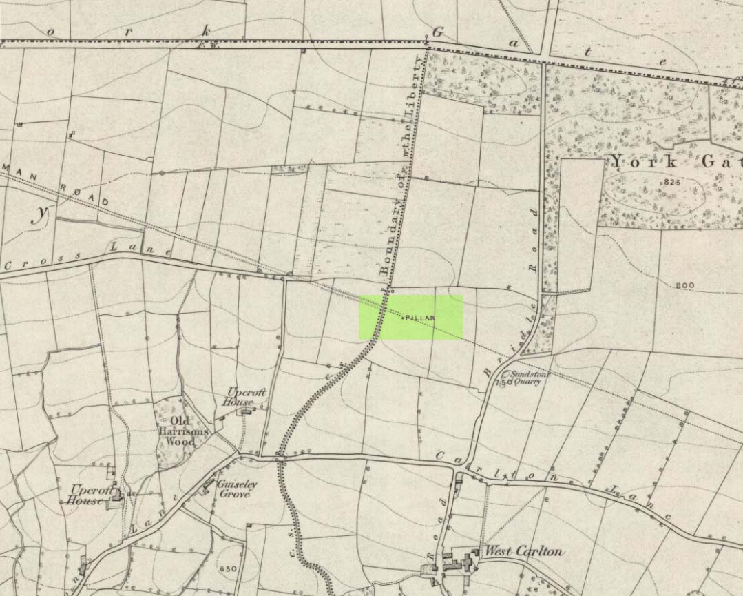
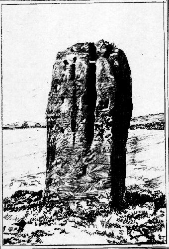
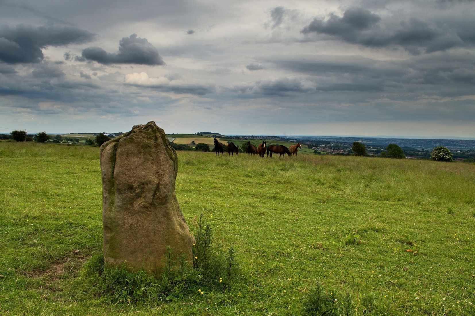
Worth checking this if you aint seen it before! Head up to the back (south-side) of Otley Chevin (where the cup-and-ring Knotties Stone lies sleeping), following the road there and park up near/at the Royalty pub. Take the footpath behind the pub which crosses the fields and once into the second field, head diagonally down to the far-left corner. From here, look over the wall — you can’t really miss it!
Archaeology & History
An intriguing site for various reasons. All we have left to see of any value nowadays is this nigh-on 6-foot tall thick monolith, standing alone in the field halfway between West Carlton and Otley Chevin. Completely missed in local archaeological surveys, the place was mentioned briefly by Slater (1880); though it appears to have been first described in detail by Eric Cowling (1946), who suspected the stone may have Roman origins (though didn’t seem too convinced!), saying that:
“near the ground the section is almost oblong, with sides three-feet six-inches by one-foot ten-inches; two feet from top, the section is almost circular.”
The fact that the stone stands very close to the line of an all-but forgotten Roman road that runs right past it added weight to this thought (the road runs towards a Roman settlement a mile east of here near Yeadon). But this standing stone is unlikely to be Roman. More recent evidence seems to indicate a relationship with a now-lost giant cairn about 100 yards to the south. The only remains we have of this place are scatterings of many small loose stones nearby. And it seems a very distinct possibility that the extra standing stones that were once hereby, stood in a line.
The very first reference I’ve found about this site also indicates that there was more than one stone here in the past! In 1720 this site was known as the ‘Boon Stones’; and the plural was still being used by the time the 1840 Tithe Awards called them the ‘Boul Stones.’ Initially it was thought that both words were plural for “bulls” — as A.H. Smith (1962) propounds in his otherwise superb survey — but this is questionable. (see Folklore)
Folklore
A piece of folklore that seems to have been described first by Philemon Slater (1880) relates to the pastime of bull-baiting here, that is –
“fastening bulls to it when they were baited by dogs, a custom…still known to the Carlton farmers” (North Yorkshire).
Cowling (1946) told that he heard the stone was said to be lucky as well as being a source of fertility. This ‘fertility’ motif may relate to the meaning of the stone’s early name, the Boon Stones. Both boon and boul are all-but obsolete northern dialect words. ‘Boul’ is interesting in its association with a prominent folklore character, as it was used as a contemptuous term “for an old man.” Now whether we can relate this boul to the notion of the ‘Old Man’ in British folklore, i.e., the devil, or satan — as with the lost standing stone of The Old Man of Snowden, north of Otley — is difficult to say.
More interestingly perhaps is the word ‘boon’, as it is an old dialect word for “a band of reapers, shearers, or turf-cutters.” This band of reapers ordinarily consisted of five or six people and would collect the harvest at old harvest times. And as the early description talks of Boon Stones, this plurality would make sense. One curious, though not unsurprising folklore relic relating to these boons was described at another megalithic site (now gone) by John Brand (1908), where in the parish of Mousewald in Dumfries,
“The inhabitants can now laugh at the superstition and credulity of their ancestors, who, it is said, could swallow down the absurd nonsense of ‘a boon of shearers,’ i.e., reapers being turned into large grey stones on account of their kemping, i.e., striving.”
Standing stones with the folklore of them being men or women turned to stone is common all over the world. If we accept the dialect word ‘boon’ as the first name of this old stone, there may once have been some harvest-time events occurred here long ago (and this is quite likely). Equally however, we must also take on the possibility that this Bull Stone has always been a loner and that its name came from the now obsolete Yorkshire word, a bull-steann, meaning a stone used for sharpening tools, or a whetstone.
Take your pick!
References:
Bennett, Paul, The Old Stones of Elmet, Capall Bann: Milverton 2001.
Brand, John, Observations on the Popular Antiquities of Great Britain – volume 2, George Bell: London 1908.
Cowling, Eric T., Rombald’s Way, William Walker: Otley 1946.
Jackson, Sidney, ‘The Bull Stone,’ in Cartwright Hall Archaeology Group Bulletin, 2:5, 1956.
Smith, A.H., English Place-Name Elements – 2 volumes, Cambridge University Press 1956.
Smith, A.H., The Place-Names of the West Riding of Yorkshire – volume 7, Cambridge University Press 1962.
Slater, Philemon, The History of the Ancient Parish of Guiseley, William Walker: Otley 1880.
Various ways to get here, but I suppose the easist is by walking along the path just above the woods from the main A61 road, where there’s the junction turn-off to Wike. You have to walk perhaps 1000 yards until eventually, a couple of hundred yards up the slope to your left (south) you’ll see the boulder stuck in the field. You’re there!
Archaeology & History
The Grey Stone, Harewood
Described first by Cowling & Hartley in 1960, this multiple-ringed carving gives the distinct impression that it aint quite as old as our more traditional cup-and-rings on the moors west and north of here – but I s’ppose we’ll never know for sure. There isn’t a central cup to this concentric-ringed carving, which is quite unusual, and which is why I get the impression that it’s from a later archaeological period. However, saying that, there are several other faint cup-markings on the southwest and east-faces of the boulder (which I forgot to photograph when I was there – idiot that I am!). Boughey and Vickerman (2003) illustrate as many as 18 other cup-marks on the rock surface – which they list as stone 399 in their survey.
Although there seems to be no folklore attached to this isolated carving, rock-art authority Graeme Chappell noted how “the midwinter full moon set behind Almscliffe Crags at its extreme northerly setting point in Bronze Age times” from this Grey Stone.
The archaeologist S.A. Moorhouse (1981) also pointed out how some of the many Grey Stones (which usually means ‘a boundary stone’, sometimes very ancient ones) found in northern England, derive their name from the old word har, which “can also mean ‘grey, hoar,’ used to describe natural boulders, possibly with cup-and-ring markings” – just as we have here!
References:
Bennett, Paul, The Old Stones of Elmet, Capall Bann: Milverton 2001.
Boughey, Keith & Vickerman, E.A., Prehistoric Rock Art of the West Riding, WYAS: Wakefield 2003.
Cowling, E.T. & Hartley, C.E., ‘A Ring-Marked Rock: The Grey Stone,’ in YAJ 1960.
Moorhouse, S.A., ‘Boundaries,’ in Faull & Moorhouse’s West Yorkshire: An Archaeological Survey, volume 2, 1981.


")