Easy enough to locate. In Grassington go up the main street a coupla hundred yards, turning left up past the small church, taking the footpath on your right heading up to the fields that stretch to the north. Don’t mistake the remains of the medieval village that you’ll pass for the Iron Age and Romano-British site that we’re heading for, another coupla hundred yards up. You’ll notice a lot of old low walling structures on the slopes heading up above you. That’s the stuff!
Archaeology & History
Despite the industrial devastation of the landscape on the hills around here, this entire area still teems with prehistoric archaeological remains, making you wonder just how much more once existed in this region. In bygone days Prof Anne Ross thought this region to be the capital of northern England in Iron Age days. She could be right: in just about every nook and cranny of small valleys and rivulets we find evidence of ancient people everywhere for miles around, settlement upon settlement in every direction you take. The remains found here at High Close Pasture typifying the examples any ardent antiquarian will come across in this region of upper Wharfedale.
Druid’s Circle (Bogg 1904)Earliest known photo in 1899
The settlement remains and ancient cultivations at High Close have been described by various writers over the last hundred years, with Edmund Bogg (1902) calling the most notable of the remains here the ‘Druid’s Altar’ (not to be confused with the other Druid’s Altar at nearby Bordley); a title that was similarly described as “The Druid’s Circle” when Eliot Curwen surveyed the area. It is also locally known as ‘The Circus’, after it being a place where celebrated events once took place. This Druid’s Circle section is,
“an oval area 150 feet long by 75 feet wide. It consists of a bank surmounted by a single or double-row of flat-topped stones about one-and-half feet high by 2 feet wide… This may have been a communal meeting place of the Iron Age folk, who cultivated these fields, and who lived in isolated huts.” (Elgee & Elgee 1933)
The notion of the circle being a communal meeting place was echoed by Mr Curwen (1928) in his slightly more detailed description of this place. He told that the interior of the Druid’s Circle had been levelled:
“It lies eight feet below the surrounding banks to the northeast and east, to which it rises with a gradient of 8 in 21. The bank to the north is less high, while to the south and west the arena, while seperated from it by the bank, is above the level of the sloping hillside. The encircling bank is surmounted by a single (and) double row of stones for three-fourths of its extent. These are apparent to the east and south, but are less so to the west, as along this side a stone wall has been built actually along the bank of the Circus; the stones belonging to this bank are, however, quite clear below the footings of the wall. From northeast round by south to southwest the row of stones is double. Those in the inner row, forty-six in number, stand some eighteen inches high; they are about two feet wide and are flat-topped, the line is almost continuous, and in parts the stones are placed edge to edge. A second row of smaller stones backs the larger ones. Entrance is obtained to the central level area by a gap to the southwest. No fosse surrounds this earthwork. To the southeast, a lynchet four feet high runs off it, while to the north a low stoney bank runs off in a NW direction, and one of the larger stony banks approaches to within a few feet of the northwest.”
In the fields above, particularly on the east and north of this notable ruined stone ring, the extensive “cultivation pastures” as they’ve been called, are evident all over the place. Hut circles and copious other antiquities can all be found within a square mile of this spot. If you like your Iron Age archaeology, this area will knock yer socks off!
…to be continued…
References:
Bogg, Edmund, Higher Wharfeland, James Miles: Leeds 1904.
Charlesworth, Miss D., ‘Iron Age Settlements and Field Systems,’ in Archaeological Journal, volume 125, 1968.
Curwen, Eliot, ‘Ancient Cultivations at Grassington,’ in Antiquity, June 1928.
Elgee, Frank & Harriett, The Archaeology of Yorkshire, Methuen: London 1933.
Raistrick, Arthur & Chapman, S.E., ‘The Lynchet Groups of Upper Wharfedale, Yorkshire,’ in Antiquity, June 1929.
Speight, Harry, Upper Wharfedale, Elliott Stock: London 1900.
Travel along the Askwith Moor Road between Blubberhouses and Askwith (near Otley) and park-up at the large gritted parking post on the moor edge. Walk straight onto Snowden Moor (east) and walk a few hundred yards north until you reach the brow of the small rounded hill, scattered with small stones and outcrop rock. The settlement is all around you!
Archaeology & History
As we already know from earlier posts on TNA, this moorland region is rich in prehistoric remains, and the settlement that I’m about to briefly describe here is another excellent site – when you can see it!
‘Hut circle’ at the rocky knoll
My first exploration here was in the company of Graeme Chappell more than 20 years ago, where we tried locating remains that had been described by Eric Cowling (1946) during a foray taking photographs of the cup-and-ring stones nearby. But due to an overgrowth of moorland vegetation at the time, the remains which Cowling described proved hard to find. Years later when Richard Stroud and I visited the place in May 2005, all the heather had been burnt back and much of what looked like the remains of an entire prehistoric village was in plain view for us to see. I was well impressed! This occurred again last year, enabling the bunch of us who came here a few times to see even more of the place. But — just like the newly discovered prehistoric settlement on Blubberhouse Moor a couple of miles north — once the heather grows back again you wouldn’t really think anything of worth was hidden here. In archaeological terms however — despite the lack of references and research by those who are paid to be archaeologists — we have one helluva little-known prehistoric settlement, complete with walling, hut circles, village hall (!), tombs, cup-and-ring carving and more, much of it probably dating from the Bronze Age, but some of the sites here indicate it was also much in use during the Iron Age period aswell.
Probably the best place to start exploring here is on the large flat rock on the rounded knoll at the edge of the moor (SE 1785 5129) with a simple cup-mark saying ‘hello’ on its surface, looking east down into the Fewston Valley and across lower Wharfedale, then veering up towards the hills above Nidderdale. The great prehistoric temple of Brimham Rocks is clearly visible from this spot aswell. Upon this rocky hillock we have a veritable scattering of several large, earthfast boulders and smaller rocks, from where much of the settlement expands, mainly to the west through to the south, across the open moors in front of you. On a clear day this is truly beautiful and quiet spot.
Line of ancient walling, running NELine of ancient walling, running SW
Just a couple of yards from the edge of the rocky knoll is a very good example of what would at first sight appear to a prehistoric hut circle. Its position at the top of this rocky knoll however, implies an additional function other than a purely domestic one. Also from here is a prominent long straight stretch of walling running roughly southwest for about 90 yards onto the moor, and also to the northeast, downhill off the moorland for some 30 yards before disappearing into undergrowth (we didn’t actually explore this lower section of walling running downhill, so there’s probably more to be found there). This long section of walling, mainly comprising small stones and rubble, with a number of larger uprights defining much of its length, is just one of several stretches of walls that are clearly visible hereby. There are also a number of other hut circles to be found scattered around this particular walled sections near the top of the rocky rise. When Eric Cowling (1946) came here he counted 10 of them here; but subsequent explorations have found at least 13 of them hereby.
One of the most notable remains here is the large D-shaped enclosure about 25 yards west of the rocky knoll. This very impressive archaeological site was curiously not included in the Nidderdale Archaeological survey report of sites in this region. Either they hadn’t done their homework correctly when they came here, or the heather must have been really deep; cos as you can see in the photo here, it’s a decent size! I tend to see this large stone enclosure as a sort of tribal gathering building of sorts — a bit like a ‘village hall’ so to speak. If you get here and see it all in context, it makes a lotta sense (not that it’s right of course, merely an opinion). With the exclusion of the Cowling D-shaped enclosure more than 80 yards east of here, this is the largest monument on this section of the moor, measuring some 45ft along the NW to SE axis and 20ft across the NE to SW axis. The walling in parts is quite thick aswell and the stones making up the main north, east and southern edges are anything between 12 inches to 34 inches tall. Along its northeast edge is a curious stone, with what initially looked to be a most distinct cup-and-ring carving on the outer walling, but once we’d looked and looked again, saw it seemed to be one of the oddest light-created ‘carvings’ we’d ever seen! (i.e., it’s natural)
Denuded cairn? or denuded walling?Another arc of walling (shit picture though – soz…)
A few yards from here, heading to the little peak close by, more walls emerge. On the small rise in the land about 30 yards west you’ll see an arc of stones running around the contour line of another hillock on the moor. It’s difficult to say with any certainty, but a lot of this arc of stone is certainly man-made and at least Iron Age in date, perhaps earlier; but the line of stones itself may actually run all round the very edges of the hill on whose sides this section rests (see photo). You get a distinct impression here that this small hill was actually sectioned off all the way round, so to speak, for some reason or other. The remains of at least two small cairns can be found on the top of this small enclosed rise, close to one of which Boughey & Vickerman (2003) have designated there to be a cup-marked stone. From this elongated hillock we look immediately northwest onto the flat moorland plain of the Snowden Moor necropolis …amidst which the hardworking Keighley volunteer Michala Potts recently found the Snowden Crags cairn circle.
Section of Snowden Carr settlement walling
Further down the moorland slope—a couple of hundred yards below Cowling’s D enclosure—are yet more remains, many of which lie outside the geographical boundaries of the “official” Scheduled Monument Record for this settlement (known as SMR 28065). We’ve located several other cairns in relatively good states of preservation; more extensive lines of another walled enclosure (again in a large D-shape), as well as several cup-marked stones.
The Site and Monuments account of this place tells us simply:
“The monument includes a cairnfield and associated concentration of prehistoric features. Included in the area are a large sub-rectangular enclosure, two smaller enclosures, at least 17 cairns of various sizes, several lengths of boulder walling, a hollow way, and at least 17 carved rocks. There is also a bare patch of ground on which lumps of lead slag survive. This was produced by medieval or earlier lead smelting.
“This concentration of prehistoric features is situated towards the north east edge of Snowden Carr, and measures c.426m x c.155m. The cairns occur throughout the area and range in size from an elongated cairn 17m x 7m down to cairns c.4m in diameter. The cairns are best preserved in the north western part of the area. The large sub-rectangular enclosure has an earth and stone bank c.3m wide and c.0.6m high. The bank is double on the east side of the enclosure. The two smaller enclosures have rubble banks 1m-2m wide and up to c.0.6m high. They are more irregular in shape than the large enclosure. The boulder walling consists of a number of approximately linear rubble banks 1m-2m wide. It is concentrated in the area immediately north west of the large enclosure, and in the area to its south. The boulder walls are interpreted as part of a field system contemporary with the large enclosure. The hollow way is located within the southern group of boulder walls and may be contemporary with them. “
There is still a considerable amount of work that needs doing in and around this settlement complex and it seems any work here is gonna be done by the like of us amateur doods. Archaeological officials don’t seem interested here. I was informed by Neil Redfern of the archaeology department of English Heritage for North Yorkshire that they are unable to support any funding that might help towards any decent analysis of this important archaeological arena, nor do they consider the important cairn circle discovered a few months ago on the northern end of this settlement worthy of financial help either, which is of course very disappointing,* but typifies their lack of enthusiasm unless money comes their way. And so this site profile entry will be added to gradually as our amateur team visit and uncover further aspects of this neglected prehistoric arena – such as the finding of another previously unrecorded ancient circle of stones not too far away!
References:
Boughey, Keith & Vickerman, E.A., Prehistoric Rock Art of the West Riding, WYAS: Wakefield 2003.
Cowling, Eric T., Rombald’s Way: A Prehistory of mid-Wharfedale, William Walker: Otley 1946.
Acknowledgements: Many thanks for use of their photos to Graeme Chappell and Michala Potts.
* No doubt a church window somewhere will eat up a few thousand quid and weeks of their time to fit the little piece — along with all those prawn sandwich meetings that cost so much to endure. Much more important!
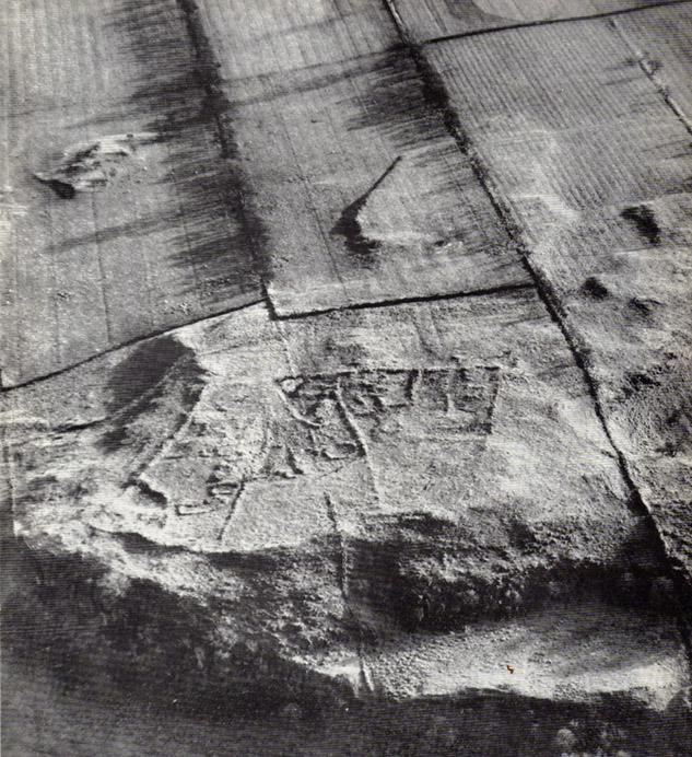
Aerial view of settlement, 1967 (courtesy, Antiquity journal)
Some of the extensive remains of an Iron Age settlement on the northeastern edges of Barrasford Common, on the edge of Toddle Crags a couple of miles north of Chollerton, are thankfully still visible, despite the increased quarrying operations taking their toll on other (now lost) prehistoric sites between the little villages of Gunnerton and Great Swinbourne. The remains of earthworks and walling are clearly visible at ground level, despite being overgrown.
The archaeologist J.K. St. Joseph (1970) described them in a short piece in Antiquity journal more than 40 years ago, saying:
“The site as first described by the reverend G. Rome Hall (1876) in the course of a survey of settlements around Birtley and Barrasford, made a century ago. It is the easternmost of three settlements that he noted on the crags east of Gunnerton, and his sketch-plan shows rather irregular enclosures within which appear a dozen hut-circles, between 27ft and 15ft…in diameter according to his account. The western of the three settlements was subsequently excavated by Rome Hall about 1880, and re-examined in 1941 by Mr A.H.A. Hogg (1942), who was able…to show that the period of occupation fell within the Roman Age. Mr Hogg refers to the earthworks illustrated (above) as ‘a very large settlement, much robbed.’
“…The site consists of a roughly square enclosure, 300ft across, or a little more, defined by a low bank… The SW and SE sides are straight: on the other two sides the boundary mark conforms to the cont0urs of the ground. The enclosure is subdivided, and evident traces of hut circles and of more rectangular-shaped buildings are still to be seen. Some of the small compounds may be pens for stock, and the general impression conveyed by the earthworks is of a settlement that has developed over a period of time, additions and rebuildings being involved. It is thus a notable example of the rectangular settlements of the Roman Iron Age, which occur widely in south Northumberland, as Mr G. Jobey has demonstrated. The earthworks compare well in point of weathering, at least in an aerial view, with the best preserved of the Iron Age settlements on the moors in the north of the county.”
The writer notes how the this settlement had evidence of continued human use all the way from the Iron Age to perhaps as late as the 18th century! This isn’t too unusual. The best example I’ve yet to come across is the little-known settlement complex in the far north, on the small plateau known as Baile Mhargaite near Bettyhill, Sutherland, where a living community began in the neolithic period and only came to an end with the Highland Clearances two hudnred years ago!
References:
Hall, George Rome, “Ancient British Remains near Birtley and Barrasford, North Tyne,” in Archaeologia Aeliana, Volume 7, 1876.
Hogg, A.H.A., “The Native Settlement at Gunnar Peak,” in Archaeologia Aeolina, Volume 20, 1942.
From the Askwith Moor car-parking spot, walk up the road (north) for 350 yards and go thru’ the gate on the left-side of the road, up along the track onto Askwith Moor. To get to it, walk on the footpath towards the trig-point on Shooting House Hill from the Askwith Road. Between 50-100 yards before the trig, walk into the heather to the right. Just 5-10 yards off the footpath, it’s there! If the heather’s grown back, don’t even bother looking for the place!
Archaeology & History
Although I add this as the remains of a small Bronze Age or neolithic settlement — which was found on August 3, 2005, in the company of Richard Stroud — subsequent walks up hereabouts in the surrounding heather has shown that, far from being a small independent site, it was part and parcel of a much greater prehistoric landscape all round here: with the remains on High Low Ridge immediately west; the cairnfields of Askwith Moor and Snowden Crags south and east; and numerous cup-and-ring stones scattered all over the place here. It’s a veritable minefield of archaeological remains, from the mesolithic to the Iron Age all over these moors!
Barely visible remains of wallingMore of the walling
We came wandering up here looking for another of Eric Cowling’s “lost circle” sites described in 1946, near Shooting House Hill, which Graeme Chappell and I looked for ten years previously without success. But on the August 2005 visit, much of the heather had been burned away. Instead of the lost circle however (which remains unfound, though something suspiciously like it is close by) we came across a well-defined, though small settlement complex. The walling of two well-defined near-rectangular structures emerge either side of a reasonably large boulder. Beyond these is further walling and what seems a well-defined hut-circle less than 10 yards away. Like many other sites on these moors, the walling seem to have been pretty much robbed for building grouse-butts. (hence the pictures here looking a bit sparse of stone!) Subsequent investigation found more neolithic walling which ran into the deeper heather — so it has been difficult to work out the full scale of it all.
The landscape from here stretches way off. To the eastern horizon (not far away) is the legendary Almscliffe Crag, with the rising hills of Rombald’s Moor due south; whilst far to the sunsetting west rises the great contours of Pendle Hill, to which legend relates some of the witches of the Fewston Valley, a mile below…
References:
Cowling, Eric T., Rombald’s Way, William Walker: Otley 1946.
Very troublesome to locate when the heather’s deep. To get here take the Askwith Moor Road heading north and park-up at the big gritted parking spot halfway along. Cross the road (west) and walk up a little and onto the moorland track. When you hit the triangulation pillar, walk down (left) onto the moor, heading for the small rise in the land a few hundred yards away. Once there, start walking down its sloping south-face, watching for any evidence after 100 yards. Be vigilant!
Archaeology & History
One of 4 hut circles in very good state of preservation
This small settlement was first found on 18 July, 2004, when a small group of us, in search of the troublesome Man Stone carving, were lucky to be on the moors shortly after the heather had been burnt back, amidst this archaeologically rich area of Askwith Moor, on the northern end of Hollin Tree Hill.
There were at least four hut circles found here (on the right of the track as you walk up the slope), with one in particular — the northernmost of the group — in a very good state of preservation. This particular circle measured approximately 20 feet in diameter, with an entrance to the south side. It is marked by a low earthfast boulder on the northeast side, visible even when the heather is deep.
Although we counted four such circles, it’s very likely that an intensive search would uncover more remains on this hillside. In revisiting this site in October 2016, the heather had grown back over the entire complex and the circles were very difficult to see; but we were able to discern the one on the very top of the hill (the one in the photo). The other hut circles, lower down the slopes, were notable only by zigzagging back and forth until we walked onto loose walling.
From the Askwith Moor dusty parking spot, walk up the road for 160 yards where, on each side of the road, you’ll see a straight line running across the moors. On the left-side (west) walk onto the moor for 50-60 yards along this line, then dead straight west into the heather for another 50-60 yards and look around. It’s hard to see if the heather’s grown.
Archaeology & History
Found by Richard Stroud on July 20, 2004, this single hut circle is in faint evidence. About twenty feet across with a section of the low walling either missing, or more probably buried in the peat. Although no other hut-circles were immediately visible, this was probably because of the excessive heather-growth. I have little doubt that others will be close to this one, as the area is littered with prehistoric sites. The petroglyph catalogued as Askwith Moor 529 is very close to this hut circle.
Get to the famous Dick Hudson’s pub on the south-side of Ilkley Moor and go east for about 700 yards till you get to Weecher reservoir (posh doods go yachting there). From here cross the road and walk on for 150 yards till you reach the stile which takes you onto the moors. Walk! Follow the footpath and you’ll go over another wall before eventually hitting the beautiful fresh waters of Horncliffe Well (this has never dried up – even in the summers of ’76 and ’95). Sit here for a while before heading for the circle which is on the east-side of the moorland fence just a coupla hundred yards up onto the moor (you’ll cross a coupla streams before reaching the site). You’ll know you’re close when, to your left by the fence, you’ll see a boundary stone with the name ‘Thos. Pulleyn’ engraved on it.
Archaeology & History
Early drawing of Horncliffe Circle (Speight 1898)
Horncliffe is a bittova strange site, inasmuch as we don’t honestly know precisely what it is, nor its age. It used to be categorized as a ‘stone circle’, but this was abandoned many moons ago. The inner circle of this ellipse-shaped monument was thought to have perhaps contained a burial, but Victorian excavations here found no such evidence; no burials have ever been found, though fires were evidently burned in the small central ring.
Nowadays I’m of the opinion that this was more for living-in, than any ritual site. It ‘smells’ like that anyway (modern OS-maps now term it as an ‘enclosure’); and this may be borne out by the ancient name of the trackway travelling north from here called ‘Castle Gate’, meaning ‘entrance or path by the fortification.’ Faint ‘cup-markings’ reported by Harry Speight (1898) on the outer edge of the ring are very likely Nature’s handiwork.
Horncliffe is a double-ringed ellipse structure, surrounded on its northern side by a natural embankment of earth. It was first mentioned in J.N.M. Colls’ (1846) survey, but more was said of it by James Wardell in 1869, who told that,
“there is a circle of stones of various sizes, from three-feet to five-feet in height; they are chiefly set upon their edges and are of sandstone grit. This circle is forty-three feet in diameter and within it there is a smaller circle, composed of stones of the same composition…and set in the same manner.”
A few years later, the Yorkshire literary giant Harry Speight (1898) penned his first words about this curious circle, saying:
“The best example of a stone circle in the vicinity of Bingley lies on the moor close to the parish boundary, on land belonging to Mr Fawkes, of Farnley Hall. It is a complete circle, consisting of about twenty stones, placed close together (a very unusual arrangement), from two to four feet high, the circumference being about 35 yards. An excavation was made in the middle of it some years ago, when bits of flint were found, but no trace of burial. It is built on a slight slope of the moor, facing the south, and is now much concealed by heather. It is, doubtless, the oldest known evidence of man’s handiwork remaining in the neighbourhood of Bingley, and there is small doubt that it was originally intended to fence a burial, such “Druids’ Circles” being primarily meant to enclose places of sepulchre in the same way that walled enclosures came to be adopted round our churchyards. A large flat stone on the top side, about three yards distant, is marked with cups and channels, and probably was in the centre of the circle originally.”
When Arthur Raistrick (1929) visited the circle, his measurements differed somewhat from those of Mr Wardell, telling the site to have diameters of 25 feet (east-west) and 32 feet (north-south), with 46 stones in the outer ring and 17 in the inner circle.
This is one of many sites on these moors that I slept at over the years when I was a kid. It used to be a really peaceful spot that was rarely troubled by other visitors (not sure if it’s still the same though).
Folklore
Although we have nothing specific to the circle, around the nearby Horncliffe Well a coupla hundred yards away we had accounts told us by the old warden whose job it was to look after this moorland, that will-o-the-wisps had been seen here. There is a seeming alignment to the equinoxes from here to Reva Hill – though this is more fortuitous than deliberate. A dowsing survey found aquastats in and around the circle, but no plan of these were ever made.
References:
Bennett, Paul, The Old Stones of Elmet, Capall Bann: Milverton 2001.
Colls, J.N.M., ‘Letter upon some Early Remains Discovered in Yorkshire,’ in Archaeologia 31, 1846.
Raistrick, Arthur, ‘The Bronze Age in West Yorkshire,’ in YAJ 1929.
Speight, Harry, Chronicles and Stories of Old Bingley, Elliot Stock: London 1898.
Pretty easy to get to. Go south through the village for a half-mile until you reach the hall by the fire station, sat back on the left-hadn side of the road a few hundred yards past Loch a’ Mhuillinn. Stop here and walk up the slope behind the hall for a hundred yards or so. Walk about!
Archaeology & History
The OS-coordinate here is a loose one. It centres on the notable hillock of Torr Mor, around which are a number of hut circles (at NG 7097 4293; NG 7139 4303; NG 7087 4309; NG 7088 4310 and NG 7090 4320) which are each in a relatively good condition and are thought to date from at least the Iron Age. When I visited them, the bracken had encroached on all but one of them (the last in the list above), which was about 30 feet across.
North of here are several curious-looking heaps of stones which need closer examination when the vegetation has died away. At first glance they would seem to be cairns, i.e. tombs. No such prehistoric graveyard has been found anywhere on the peninsula as yet – but considering the existence of the settlements in the area at Sand, you’d think there’d be one somewhere!
Truly takes a bit of finding this one! I s’ppose the easiest way to locate it is by approaching it from the south, from Askwith village, up Hall Lane. Keep walking up the footpath to Top Moorside Farm; then past it, sticking to the same path. A hundred yard or so past here we get onto the moor itself. As you hit the moor, you’ll see that the land rises slowly ahead of you: this is Hollin Tree Hill and you need to walk up here (don’t do this in the summer as it’ll be covered in bracken and you’ll not find a damn thing!). Just before the land starts to levels-out at the top of this small rise, you’ll come across some hut circles. You’re here!
image courtesy of Graeme Chappell
You can also come to this carving via the Askwith Moor parking-bit, then walk along the well-trod footpath, past the triangulation pillar of Shooting House Hill for a coupla hundred yards, then walk straight south into the moor. But to those of you who aint got the nose for it, there’s no footpaths here and some folk might easily lose their way. However, if you reach the rise of Hollin Tree Hill a few hundred yards down the moor, watch out for those same hut circles mentioned elsewhere atop of the rising land. You’re damn close!
Archaeology & History
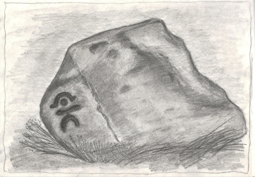
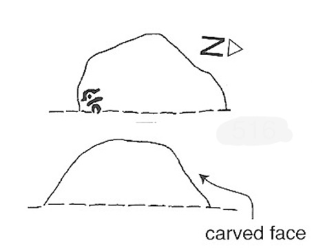
One of my very favourite cup-and-ring carvings this one! It was discovered about 1991 when Graeme Chappell and I were on one of our many archaeology wanderings, seeking out prehistoric remains on the moors north of Ilkley. First described and illustrated in Bob Trubshaw’s (1996) archaeomythics journal, it was later included in The Old Stones of Elmet (2001: 149-152). But when we first found it, this carving – on the vertical face of a small stone, beside an unexcavated hut circle – sent me a bit crazy, as the ‘human’ image in the carving struck me immediately. Needless to say, Graeme was all calm about it while I jumped around like an excited tit! As far as we’re aware, this is the earliest representation of a human figure in the British Isles. There are several other contenders in cup-and-ring design, but this seems the most probable of the lot. Graeme Chappell took a rubbing of the stone several years after we’d found it and the outline clearly shows the image of a human figure. The carving was later catalogued by rock art students Boughey & Vickerman (2003) in their Yorkshire survey as ‘stone 516.’ A female compatriot, the Woman Stone, can be found a few hundred yards east of here, at the bottom of the slope by the near horizon.
The fact that the carving occurs on the southern vertical face of a prehistoric hut circle may have had some significance about the structure itself. Petroglyphs on hut circles are rare—and this one occurs right at the entrance to the structure, the door into the circle. It may represent an image of the person who lived in this hut circle, or perhaps symbolized the nature of the character living there. The carving shows that the person was wearing a head-dress, akin to a horned-man figure – but much much earlier than anything previously recognised in British iconography. The figure may well be a shaman who, perhaps, lived at this circle. The carving was probably painted in lichens and other dyes
The Man Stone carvingBoughey & Vickerman sketch
Be careful not to wander around looking for this when there’s fog on the hills. You’re unlikely to find it! On an excursion up here several years back with Prof. Thomas Dowson and students from the Southampton University Rock Art course, we wandered about all over the place in the dense fog but were unable to find the damn thing! Twas a bittova freaky day, as half the students started crying (they thought I’d got them truly lost in the middle of nowhere as I didn’t have a map, a compass, walking boots, etc – which is how I usually do my wanderings, but they weren’t to know that!) and we must have walked within 10 yards of the carving, but it remained hidden from our prying eyes. But if you like your rock art, check this one out!
")
")
")