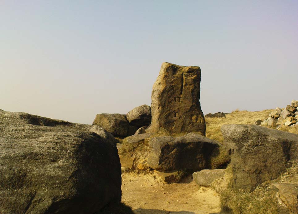
Calderstones, Allerton, Liverpool, Lancashire

Chambered Tomb (damaged) & Cup-and-Ring Stones:  OS Grid Reference – SJ 405 875
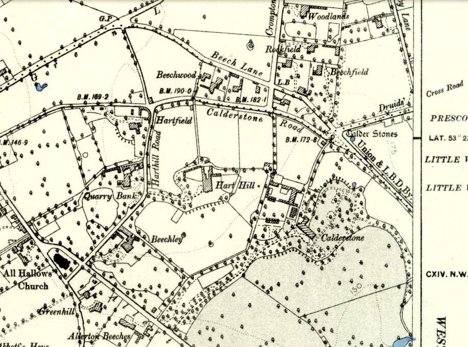
Calderstones on 1889 OS-map

Also Known as:

  1. Calder Stones
  2. Caldway Stones
  3. Dogger Stones
  4. Druid’s Cross
  5. Rodger Stones

Getting Here

Access to these stones has, over recent years been pretty dreadful by all accounts.  It’s easy enough to locate. Go into Calderstones Park and head for the large old vestibule or large greenhouse.  If you’re fortunate enough to get one of the keepers, you may or may not get in.  If anyone has clearer info on how to breach this situation and allow access as and when, please let us know.

Archaeology & History

Earliest known drawing from 1825, showing the carvings

Marked on the 1846 Ordnance Survey map in a position by the road junctions at the meeting of township boundaries, where the aptly-named Calderstones Road and Druids Cross Road meet, several hundred yards north of its present site in Harthill Greenhouses in Calderstones Park, this is a completely fascinating site whose modern history is probably as much of a jigsaw puzzle as its previous 5000 years have been!

Thought to have originally have been a chambered tomb of some sort, akin to the usual fairy hill mound of earth, either surrounded by a ring of stones, or the stones were covered by earth.  The earliest known literary reference to the Calderstones dates from 1568, where it is referenced in a boundary dispute, typical of the period when the land-grabbers were in full swing.  The dispute was over a section of land between Allerton and Wavertree and in it the stones were called “the dojer, rojer or Caldwaye stones.”  At that time it is known that the place was a roughly oval mound.  But even then, we find that at least one of the stones had been taken away, in 1550.

Little was written about the place from then until the early 19th century, when descriptions and drawings began emerging.  The earliest image was by one Captain William Latham in 1825.  On this (top-right) we have the first hint of carvings on some of the stones, particularly the upright one to the right showing some of the known cup-markings that still survive.  By the year 1833 however, the ‘mound’ that either surrounded or covered the stones was destroyed.  Victorian & Paul Morgan (2004) told us,

“The destruction first began in the late 18th or early 19th century when the mound was largely removed to provide sand for making mortar for a Mr Bragg’s House on Woolton Road.  It was at this time that a ‘fine sepulchral urn rudely ornamented outside’ was found inside.”
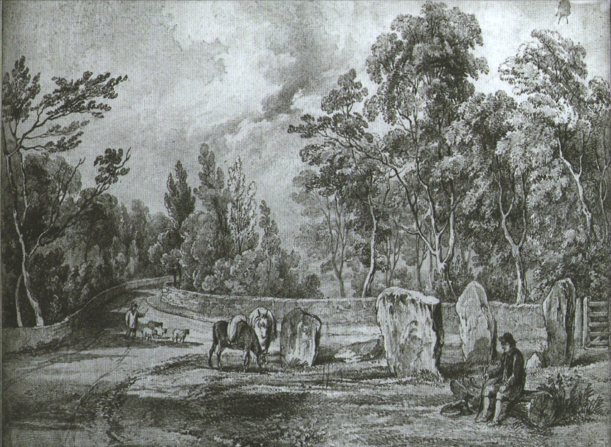
The Calderstones in 1840

The same authors narrated the account of the mound’s final destruction, as remembered by a local man called John Peers—a gardener to some dood called Edward Cox—who was there when it met its final demise.  Mr Cox later wrote a letter explaining what his gardener had told him and sent it to The Daily Post in 1896, which lamented,

“When the stones were dug down to, they seemed rather tumbled about in the mound.  They looked as if they had been a little hut or cellar.  Below the stones was found a large quantity of burnt bones, white and in small pieces.  He thought there must have been a cartload or two.   He helped to wheel them out and spread them on the field.  He saw no metal of any sort nor any flint implements, nor any pottery, either whole or broken; nor did he hear of any.  He was quite sure the bones were in large quantity, but he saw no urn with them.  Possibly the quantity was enhanced by mixture with the soil.  No one made such of old things of that sort in his time, nor cared to keep them up…”

But thankfully the upright stones remained—and on them were found a most curious plethora of neolithic carvings.  After the covering cairn had been moved, the six remaining stones were set into a ring and, thankfully, looked after.  These stones were later removed from their original spot and, after a bit of messing about, came to reside eventually in the curious greenhouse in Calderstones Park.
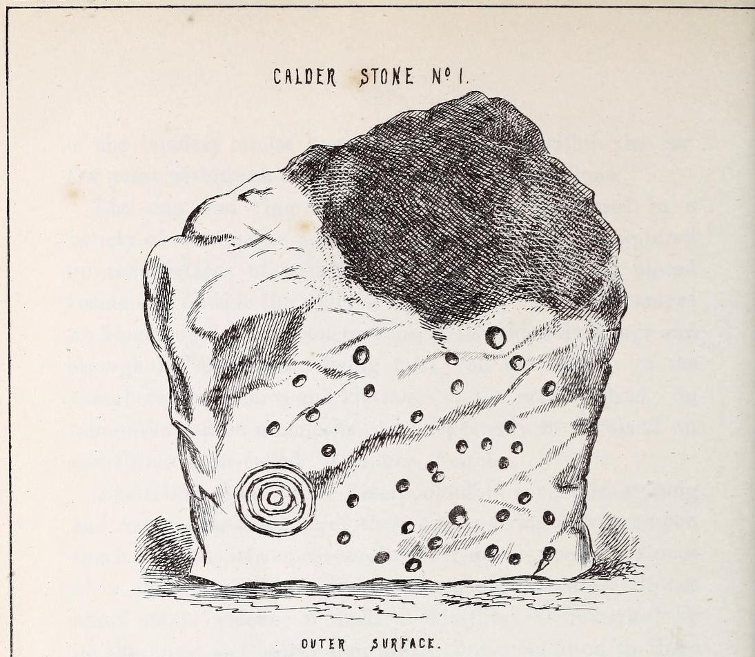
Simpson's "Stone 1" outer face
Simpson’s “Stone 1” outer face
Simpson's "Stone 1" inner face
Simpson’s “Stone 1” inner face

The carvings on the stones were first described in detail by the pioneering James Simpson. (1865)  I hope you’ll forgive me citing his full description of them—on one of which he could find no carvings at the time, but he did state that his assessment may be incomplete as the light conditions weren’t too good.  Some things never change!  Sir James wrote:

“The Calder circle is about six yards in diameter. It consists of five stones which are still upright, and one that is fallen. The stones consist of slabs and blocks of red sandstone, all different in size and shape.

“The fallen stone is small, and shews nothing on its exposed side; but possibly, if turned over, some markings might be discovered on its other surface.

“Of the five standing stones, the largest of the set (No. I) is a sandstone slab, between five and six feet in height and in breadth.  On its outer surface—or the surface turned to the exterior of the circle— there is a flaw above from disintegration and splintering of the stone; but the remaining portion of the surface presents between thirty and forty cup depressions, varying from two to three and a half inches in diameter; and at its lowest and left-hand corner is a concentric circle about a foot in diameter, consisting of four enlarging rings, but apparently without any central depression.

“The opposite surface of this stone, No. 1, or that directed to the interior of the circle, has near its centre a cup cut upon it, with the remains of one surrounding ring. On the right side of this single-ringed cup are the faded remains of a concentric circle of three rings.  To the left of it there is another three-ringed circle, with a central depression, but the upper portions of the rings are broken off.  Above it is a double-ringed cup, with this peculiarity, that the external ring is a volute leading from the central cup, and between the outer and inner ring is a fragmentary line of apparently another volute, making a double-ringed spiral which is common on some Irish stones, as on those of the great archaic mausoleum at New Grange, but extremely rare in Great Britain.  At the very base of this stone, and towards the left, are two small volutes, one with a central depression or cup, the other seemingly without it.  One of these small volutes consists of three turns, the other of two.

“The next stone, No. 2 in the series, is about six feet high and somewhat quadrangular.  On one of its sides, half-way up, is a single cup cutting; on a second side, and near its base, a volute consisting of five rings or turns, and seven inches and a half in breadth ; and on a third side (that pointing to the interior of the circle), a concentric circle of three rings placed half-way or more up the stone.

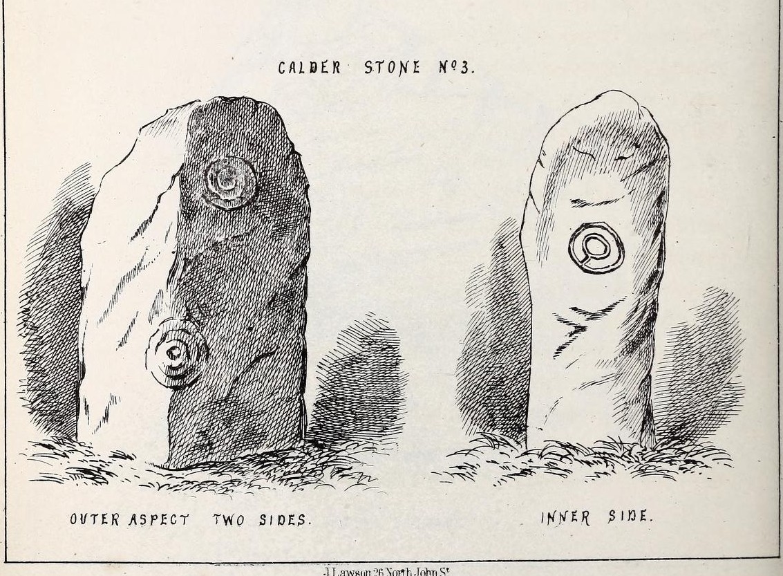
“The stone No. 3, placed next to it in the circle, is between three and four feet in height; thick and somewhat quadrangular, but with the angles much rounded off. On its outermost side is apparently a triple circle cut around a central cup; but more minute examination and fingering of the lines shews that this figure is produced by a spiral line or volute starting from the central cup, and does not consist of separate rings.  The diameter of the outermost circle of the volute is nearly ten inches. Below this figure, and on the rounded edge between it and the next surface of the stone to the left, are the imperfect and faded remains of a larger quadruple circle. On one of the two remaining sides of this stone is a double concentric circle with a radial groove or gutter uniting them. This is the only instance of the radial groove which I observed on the Calder Stones, though such radial direct lines or ducts are extremely common elsewhere in the lapidary concentric circles.

“The stone No. 4 is too much weathered and disintegrated on the sides to present any distinct sculpturings. On its flat top are nine or ten cups ; one large and deep (being nearly five inches in diameter).  Seven or eight of these cups are irregularly tied or connected together by linear channels or cuttings…

“The fifth stone is too much disfigured by modern apocryphal cuttings and chisellings to deserve archaeological notice.

“The day on which I visited these stones was dark and wet. On a brighter and more favourable occasion perhaps some additional markings may be discovered.”
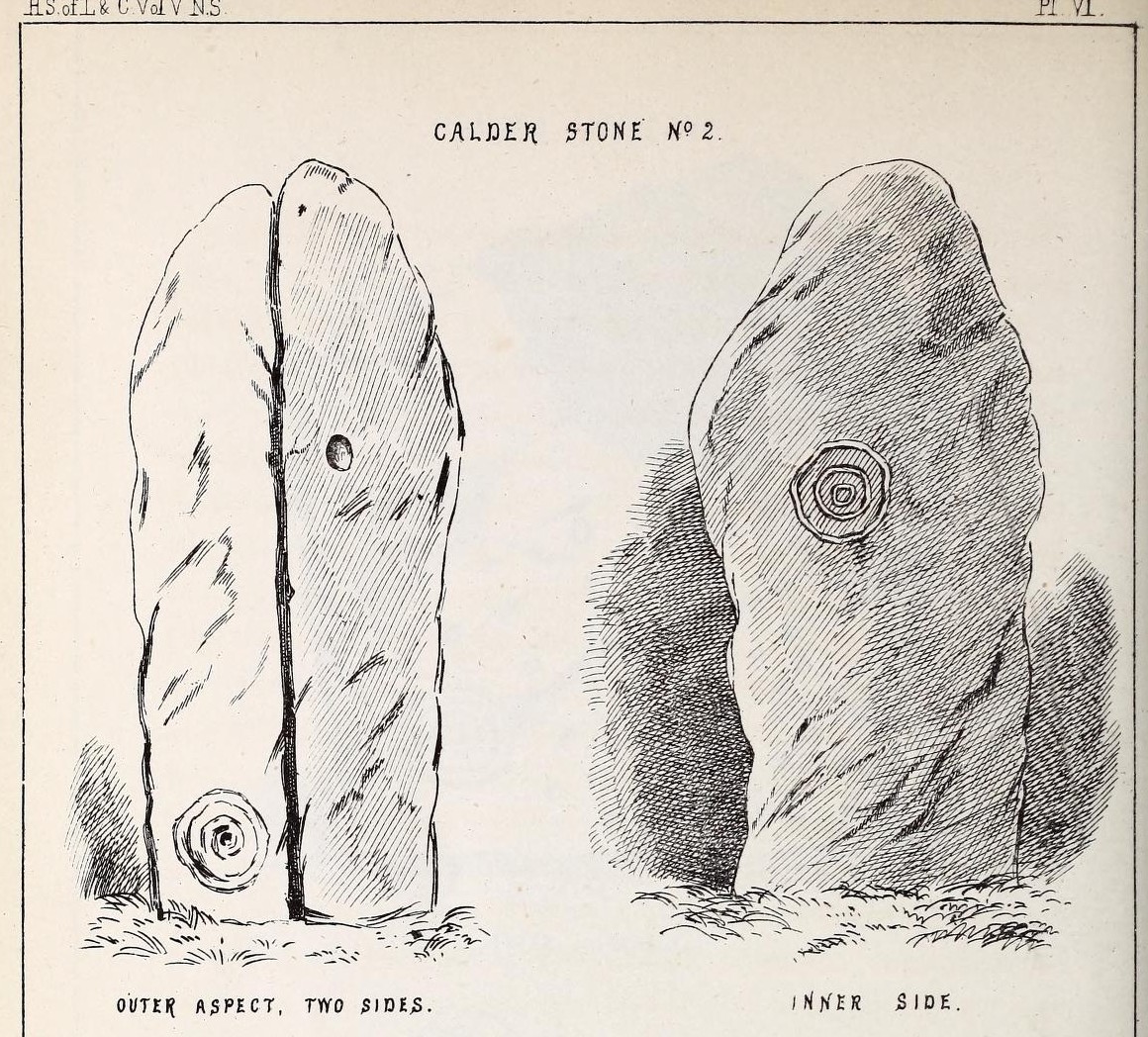
Simpson's 'Stone 2' carving
Simpson’s ‘Stone 2’ carving
Simpson's 'Stone 3' carving
Simpson’s ‘Stone 3’ carving

It wasn’t long, of course, before J. Romilly Allen (1888) visited the Calderstones and examined the carvings; but unusually he gave them only scant attention and added little new information. Apart from reporting that another of the monoliths had carvings on it, amidst a seven-page article the only real thing of relevance was that,

“Five of the Calderstones show traces, more or less distinct, of this kind of carving, the outer surface of the largest stone having about thirty-six cups upon it, and a set of four concentric rings near the bottom at one corner. One of the stones has several cups and grooves on its upper surface.”
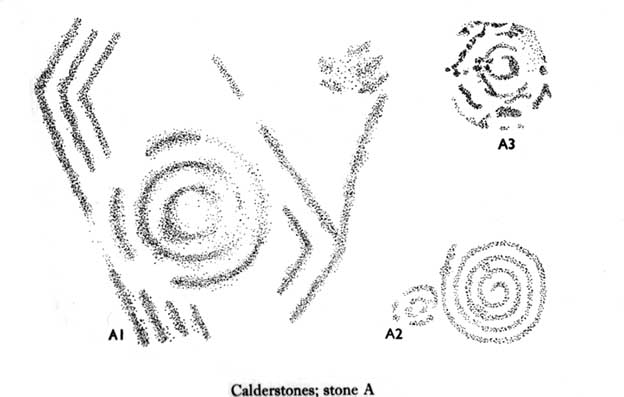
Carvings on Stone A (after Forde-Johnson)
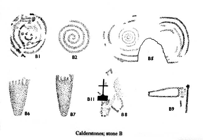
Carvings on Stone B (after Forde-Johnson)

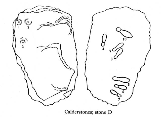
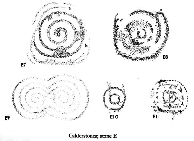
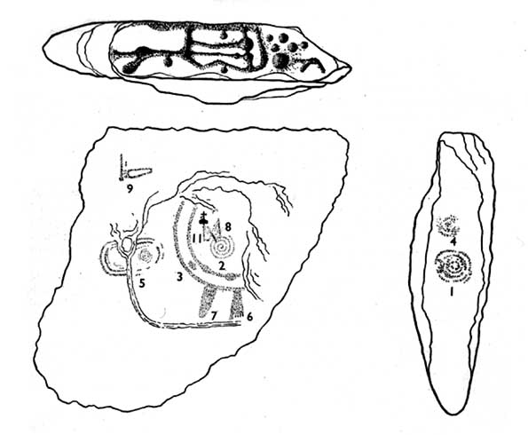
Unusual for him!  The major survey of the Calderstone carvings took place in the 1950s when J.L. Forde-Johnson (1956; 1957) examined them in great detail.  His findings were little short of incredible and, it has to be said, way ahead of his time (most archaeo’s of his period were simply lazy when it came to researching British petroglyphs).  Not only were the early findings of Sir James Simpson confirmed, but some fascinating rare mythic symbols were uncovered that had only previously been located at Dunadd in Argyll, Cochno near Glasgow, and Priddy in Somerset: human feet – some with additional toes!  Images of feet were found to be carved on Stones A, B and E.  A carved element on Stone C may even represent a human figurine—rare things indeed in the British Isles!
Carvings on Stone D
Carvings on Stone D
Carvings on Stone E
Carvings on Stone E

The detailed sketches here are all from Forde-Johnson’s 1957 article, where five of the six stones were found to bear petroglyphs (the sixth stone has, more recently, also been found to also possess faint carvings of a simple cup-mark and five radiating lines).

Elements on Stone C (after Forde-Johnson)
More elements on Stone C (after Forde-Johnson)

The date of the site is obviously difficult to assess with accuracy; but I think it is safe to say that the earlier archaeological assumptions of the Calderstones being Bronze Age are probably wrong, and the site is more likely to have been constructed in the neolithic period.  It’s similarity in structure and form to other chambered tombs—mentioned by a number of established students from Glyn Daniel (1950) to Frances Lynch—would indicate an earlier period.  The fact that no metals of any form have ever been recovered or reported in any of the early accounts add to this neolithic origin probability.

There is still a lot more to be said about this place, but time and sleep are catching me at the mo, so pray forgive my brevity on this profile, until a later date…

Folklore

Curiously, for such an impressive site with a considerable corpus of literary references behind it, folklore accounts are scant.  The best that Leslie Grinsell (1976) could find in his survey was from the earlier student C.R. Hand (1912), who simply said that,

“They were looked upon with awe by the people about as having some religious significance quite beyond their comprehension.”

There is however, additional Fortean lore that has been written about these stones and its locale by John Reppion (2011).

References:

  1. Allen, J. Romilly, “The Calderstones, near Liverpool,” in Journal of the British Archaeological Association, volume 44, 1888.
  2. Ashbee, Paul, The Bronze Age Round Barrow in Britain, Phoenix House: London 1960.
  3. Baines, Thomas, Lancashire and Cheshire, Past and Present – volume 2, William MacKenzie: London 1870.
  4. Beckensall, Stan, British Prehistoric Rock Art, Tempus: Stroud 1999.
  5. Beckensall, Stan, Circles in Stone: A British Prehistoric Mystery, Tempus: Stroud 2006.
  6. Cowell, Ron, The Calderstones – A Prehistoric Tomb in Liverpool, Merseyside Archaeological Trust 1984.
  7. Crawford, O.G.S., The Eye Goddess, Phoenix House: London 1957.
  8. Daniel, Glyn E., The Prehistoric Chamber Tombs of England and Wales, Cambridge University Press 1950.
  9. Faulkner, B.M., “An Analysis of Three 19th-century Pictures of the Calderstones,” in Merseyside Archaeological Journal, volume 13, 2010.
  10. Forde-Johnson, J.L., “The Calderstones, Liverpool,” in Powell & Daniel, Barclodiad y Gawres: The excavation of a Megalithic Chambered Tomb in Anglesey, Liverpool University Press 1956.
  11. Forde-Johnson, J.L., “Megalithic Art in the North West of Britain: The Calderstones, Liverpool,” in Proceedings of the Prehistoric Society, volume 23, 1957.
  12. Grinsell, Leslie, Folklore of Prehistoric Sites in Britain, David & Charles: Newton Abbot 1976.
  13. Hand, Charles R., The Story of the Calderstones, Hand & Co.: Liverpool 1912.
  14. Harrison, Henry, The Place-Names of the Liverpool District, Elliot Stock: London 1898.
  15. Herdman, W.A., A Contribution to the History of the Calderstones, near Liverpool,” in Proceedings & Transactions of the Liverpool Biological Society, volume 11, 1896.
  16. Morgan, Victoria & Paul, Prehistoric Cheshire, Landmark: Ashbourne 2004.
  17. Nash, George & Stanford, Adam, “Recording Images Old and New on the Calderstones in Liverpool,” in Merseyside Archaeological Journal, volume 13, 2010.
  18. Picton, James A., Memorials of Liverpool – 2 volumes, Longmans Gree: London 1875.
  19. Reppion, John, “The Calderstones of Liverpool,” in Darklore, volume 6, 2011.
  20. Roberts, D.J., “A Discussion Regarding the Prehistoric Origins of Calderstones Park,” in Merseyside Archaeological Journal, volume 13, 2010.
  21. Simpson, J.Y., “On the cup-cuttings and ring cuttings on the Calderstones, near Liverpool,” in Proceedings of the Historic Society of Lancashire and Cheshire, volume 17, New Series 5, 1865.
  22. Simpson, James, Archaic Sculpturings of Cups, Circles, etc., Upon Stones and Rocks in Scotland, England and other Countries, Edmonston & Douglas: Edinburgh 1867.
  23. Taylor, Isaac, Words and Places, MacMillam: London 1885.
  24. Stewart-Brown, Ronald, A History of the Manor and Township of Allerton, Liverpool 1911.

Acknowledgements With huge thanks to the staff at Calderstones Park; thanks also to the very helpful staff at Liverpool Central Library.

© Paul Bennett, The Northern Antiquarian


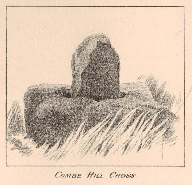
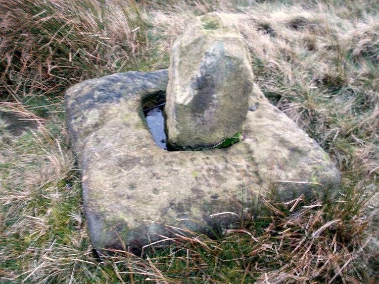
Coombe Hill Cross, Wycoller, Lancashire

Cross:  OS Grid Reference – SD 95586 38608

Also Known as:

  1. Combe Hill Cross

Getting Here

Coombe Hill Cross, Lancashire (photo credit, Ray Spencer)
Coombe Hill Cross (photo by Ray Spencer)

Along the high moorland road between Laneshaw Bridge up towards Oakworth, on the Lancashire side of the moors a half-mile before reaching the Watersheddles reservoir, past the derelict pub until you reach the isolated Coombe Cross farmhouse on the tops.  Across the road from here is a boggy footpath leading onto the moors.  Walk on here for 100 yards, where the path bends left and another footpath veers up higher onto the moors.  Walk up here for 20 yards and you’ll see the small monolith 10 yards away in the grassy heaths on your left.

Archaeology & History

Taylor's 1906 drawing
Taylor’s 1906 drawing

Found on the old route between the counties of Yorkshire and Lancashire, this little-known wayside cross has seen better days.  Found in relative isolation from other monuments by the ancient trackway (Herder’s Cross is a mile WNW, and the curious Water Sheddles Cross a mile east), its history is quiet and it was ignored in the general surveys of such monuments by Rimmer (1875), Tyack (1900) and Vallance. (1920)  Thankfully the giant survey of Henry Taylor (1906) did not forget it—although he seemed to know little of its story, merely telling us,

“The base-stone and part of the upright shaft of this cross stand about one hundred yards in a south-easterly direction from (Far Combe Hill Cross)… Two hundred yards south of the Combe Hill Cross occur the words, ‘Cross Bent.'”

Coombe Hill Cross (photo by Ray Spencer)

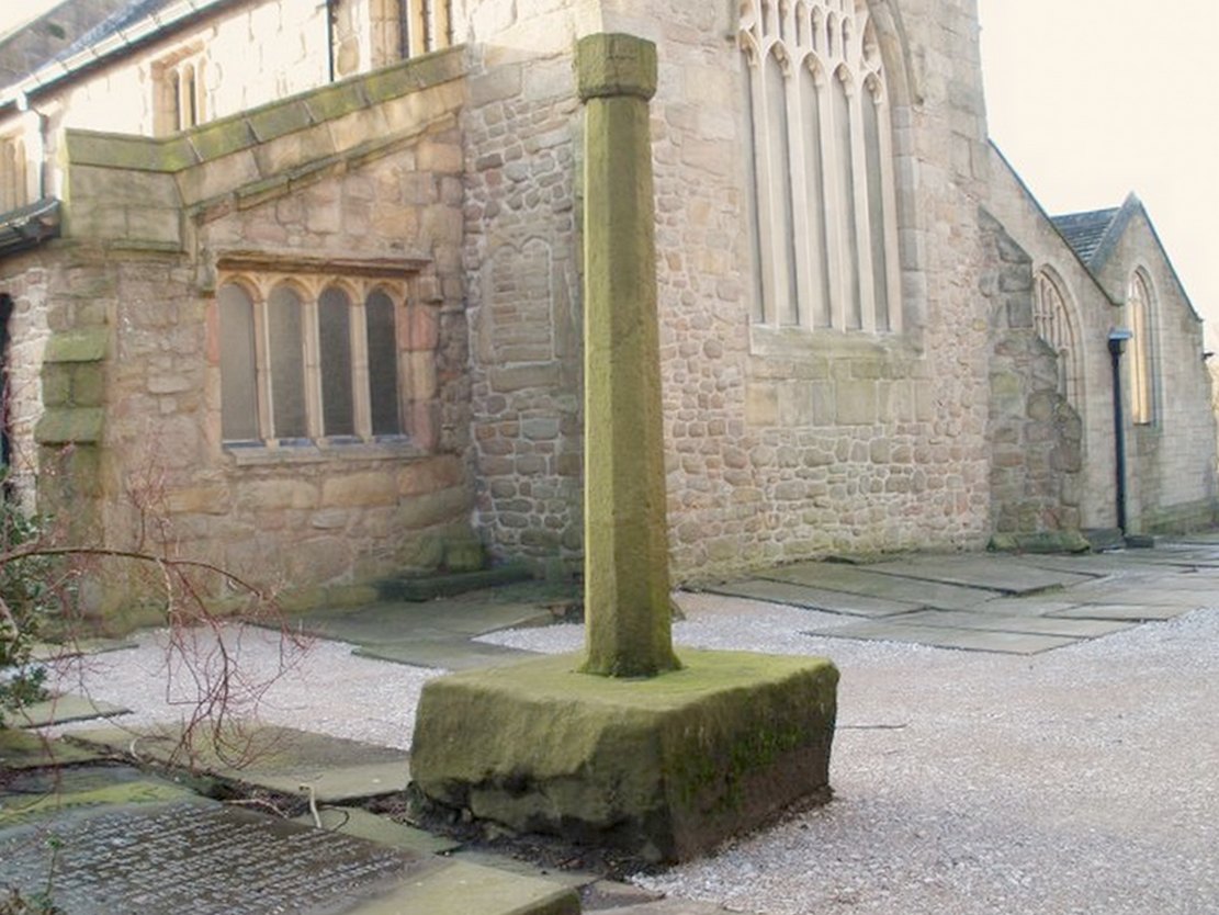
The near-square stone base—about 3 feet by 3 feet—is commonly ascribed as medieval in origin and it’s thought that the remaining upright cross-stump—over 2 feet high—is probably not the original one. When fellow antiquarian Ray Spencer visited the site recently, he reported there to be “a faint inscription on the base saying COMBE HILL CROSS.”

The most detailed account of this monument was to be found in Clifford Byrne’s (1974) unpublished paper on the antiquities of the region, where he wrote:

“The pedestal of this cross with a piece of stone sitting in it which may or may not be part of the original monolith is situated on a wayside hillock… On passing the Herders Inn above Emmot, scrutiny of the left hand side of the road at the top of the next rise ahead opposite a white farmhouse will show what looks like a stumpy finger pointing to the sky.  Close inspection will show that at the site sits the pedestal of a cross, apparently settled on two steps.  Note that the pedestal and the supporting stones beneath have a remarkable resemblance to Carlton Cross which stands on Cross Green between Tom Cross Ainslack and Carleton village near Skipton.  It may be that both monoliths were erected by the same hands.  Whether the supporting blocks beneath the pedestal were for purposes of kneeling, or merely to stop the edifice sinking into the moor is…open to dispute.  An ancient track passes the cross site where it splits into two: one going east towards Keighley and  the other going south towards Haworth by Watersheddles Cross.  A continuation of the track westwards travels along the foot of Boulsworth Hill past Iron Age burials,* along a fine set of pack horse setts, past standing stones, old lime kilns, and eventually leaving behind some remains of the Wycoller Vaccary stones near Antly Gate Farm.  It tops the brow of a hill and drops down through Thursden by the Cold Well itself a a little green gate in the reservoir wall. Marquis of Colne suggested that the Combe Hill Cross dates from the time of King Stephen in the 12th century, but does not say on what he based his surmise…. If the origin of the stone is dated correctly, it has stood near Colne for over 800 years.”

References:

  1. Byrne, Clifford, A Survey of the Ancient Wayside Crosses in North-East Lancashire, unpublished 1974.
  2. Taylor, Henry, The Ancient Crosses and Holy Wells of Lancashire, Sherratt & Hughes: Manchester 1906.

These Iron Age burials may be Bronze Age as we have found remains of several hut circles dating from that period in this area. PB.

AcknowledgementsHuge thanks to Ray Spencer for use of his photos and additional data for this site profile.

© Paul Bennett, The Northern Antiquarian

High Cross, Shrewsbury, Shropshire

Cross (destroyed):  OS Grid Reference – SJ 492 126

Also Known as:

  1. Butter Cross
  2. The Cross

Archaeology & History

This long-lost medieval ornamented cross, found not far from the legendary Grope Cunt Lane (I kid you not) was located close to the middle of old Shrewsbury town, “at the junction of Pride Hill, Castle St and St. Mary’s St,” according to the 1902 OS-map of the region.

Although Shrewsbury’s High Cross is believed to have been built in the 12th or 13th century, we don’t know for sure when it was first erected — and indeed, written records of the place don’t appear to begin until the year 1557, where it was described as the ‘Hye Crosse.’  A few years later in the Parish Registers for the Lichfield diocese, dated 1590, the monument was mentioned again as ‘the Highe Crosse’; and subsequent accounts of it are found in various local history accounts from 1695 to 1799.

The site was named as the Butter Cross in street-name listings of 1804, telling it as a site where this food was sold and we know that the High Cross was the centre of a local market and social gathering place in previous centuries.  Gelling (2004) told that “the medieval cross was taken down in 1705, but the name continued to be applied to structures which replaced it, and which were used as a market place for dairy produce.”

In earlier times, the High Cross is said in legend to have been where executions were enacted.  Alfred Rimmer (1875) narrates the oft-told tale of those who died here, saying:

“The High Cross of Shrewsbury has long been destroyed, but its place is pointed out in old documents.  Unhappily, it is not connected with pleasant associations, for before it the last of the British princes, David, a brother of Llewellyn, was cruelly put to death by Edward I; and at a later period many of the nobility who were taken at the battle of Shrewsbury were there executed, the High Cross being considered the most appropriate place for such a spectacle.”

The prince that Rimmer mentions was Dafydd III, the last prince of Wales, executed in the year 1283.

References:

  1. Gelling, Margaret, The Place-Names of Shropshire – volume 4, EPNS: Nottingham 2004.
  2. Hobbs, J.L., Shrewsbury Street Names, Wilding & Son: Shrewsbury 1954.
  3. Rimmer, Alfred, Ancient Stone Crosses of England, Virtue: London 1875.

© Paul Bennett, The Northern Antiquarian

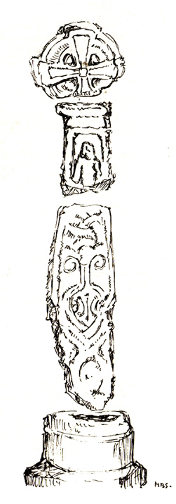
St. James Church cross, Burton-in-Kendal, Cumbria

Cross:  OS Grid Reference – SD 5305 7692

Archaeology & History

As with many old churches, St. James’ at the northern side of the village has remains of old cross fragments that can be seen inside.  They were described at some length in W.S. Calverley’s (1899) excellent work on such monuments.  Mr Langham (1972) also gave a good account of the respective cross fragments in his short work on this history of the church, listing the sections as a, b, c, d and e.  He wrote:

“a) the greater part of a wheel-head, the reverse side of which has a sunk centre instead of a raised boss, making it a five hole cross.  Calverley remarks, “a rarity in the district.”

“b) probably the top of a shaft having on its face a panel with a defaced figure, and conventional ornaments on the side.

“c) probably the lower part of a shaft with figures in two panels, and with incised interlacing designs on the reverse side “of late Scandinavian type, resembling fibulae of the Viking Age.”  On the face, the lower panel is Christ risen or rising from the tomb. He is trampling on a serpent and carries a palm of victory in his left hand.  The panel above has two figures, suggested by Calverley to be “either John or Mary, or two angels.”

“d) the neck of a cross. Calverley notes that the execution of the wheel-head and the shaft-fragments was by a hacking not a chiselling method, and he makes the comment: “The shafts and head at Burton are similar in workmanship to those at Halton.  The Halton crosses and not Norse in style, but are like late pre-Norman work in Yorkshire, where the Danes lived.”

“e) a part of a second shaft with a zigzag pattern.  Calverley says that “it is neatly chiselled, and the designs suggests a Norman date, although it seems to belong to a cross of Saxon type.”  The Royal Commission volume dates it as the 10th or 11th century.”

St James church cross (by M.D.S. Brown-Smith)

The Royal Commission volume dates the cross shafts as “probably late 10th century.”  Sir Nikolaus Pevsner in a recent book,  Guide to Cumberland and Westmorland states specifically that, “Christ, the Virgin and St. John are on the Burton-in-Kendale cross.” This is too explicit a statement in view of the deterioration in the detail.

Nearby to the northeast used found to be the remains of a holy well dedicated to St. Helen.  Does anyone have further information about it?

References:

  1. Calverley, W.S., Notes on the Early Sculptured Crosses, Shrines and Monuments in the Early in the Present Diocese of Carlisle, T. Wilson: Kendal 1899.
  2. Langham, John G., Parish Church of St. James, Burton-in-Kendal, Mayoh Press: Carnforth 1972.

© Paul Bennett, The Northern Antiquarian

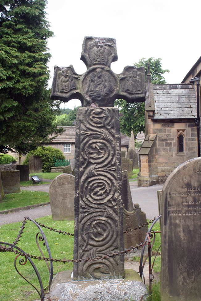
Eyam Cross, Eyam, Derbyshire

Cross:  OS Grid Reference — SK 2178 7639

Getting Here

The village of Eyam is located some 9 miles south-east of Chapel-en-le-Frith and about the same from Sheffield, which lies to the north-east. Go to the centre of the village and find the church of St Lawrence standing beside the road to Foolow close to Eyam Hall and just west of the B6521 road to Sheffield.  The Saxon cross stands in the churchyard.

History and Folklore

Eyam Cross, east face (from Wikipedia)

This very fine Anglo-Saxon (Mercian) cross stands 8 foot tall and dates from the 8th-9th centuries. It was apparently set up by missionaries from the north at Cross Low on the moors to the west of Eyam. Originally it was a wayside preaching cross that was 10 feet high and certainly must have looked very spectacular, but now it is only 8 feet high due to it being knocked about a bit in more recent times and losing one of its shaft sections. In the 18th century the cross was discovered beside a trackway on the moors, from whence it was brought to the churchyard of St Lawrence’s church;  but then for a long time it stood abandoned and uncared for in the corner of the churchyard. Eventually  it was restored and placed in the churchyard where it now stands proudly.

The cross is said to be the only one of its type in the Midlands that retains its cross-head. It has some very rich decoration on the west face with fabulous interlacing scroll-work running up the shaft that is typically Mercian in origins. On the west-face, especially the upper section, there are human figures probably St Mary the Virgin with the baby Jesus, angels and Christ in glory, each in their own sections or panels. The cross is grade 1 listed.  St Lawrence’s church houses a Saxon font.

References:

  1. Rev. Arthur, C., Illustrated Notes on English Church History, Society for Promoting Christian Knowledge: London 1901.
  2. Rodgers, Frank, Curiosities of Derbyshire and the Peak District, Derbyshire Countryside Ltd 2000.

Copyright ©  Ray Spencer 2011 


Rocester Church Cross, Staffordshire

Cross:  OS Grid Reference – SK 11170 39394

Getting Here

Rocester Church Cross

The Staffordshire village of Rocester is 4 miles north of Uttoxeter on the B5030 road. It can easily be reached from Stoke on Trent, Leek and Ashbourne. The church of St Michael with its interesting Medieval church-yard cross is located on Dove Lane in the centre of the pretty little, olde-worlde village.

Archaeology & History

The cross stands some 40 yards away from St Michael’s church. It is quite a striking monument standing 20 feet high and dating from the 13th century. It stands on 3 tier circular steps displaying convexed mouldings and a graduated base stone. It’s long, tapering shaft is described as “quadrilobe” which has sunken dog-tooth, or fret-work decoration on two sides. Unfortunately, the head is missing, but it’s collared coronet remains in place.

The Rocester church-yard cross was listed as Grade II in 1966 and the English Heritage Building ID is 407190.

Copyright © Ray Spencer 2011


Foldys Cross, Towneley, Burnley, Lancashire

Cross:  OS Grid Reference – SD 8523 3066

Also Known as:

  1. Foldy’s Cross

Getting Here

To get to Towneley Park head to the south side of the town close to a junction of two roads heading towards Todmorden and Bacup, from here the park and hall are signposted. The old cross stands 300 metres south-west of Townley Hall in the centre of some pathways leading in the direction of Todmorden road (the A671).

Archaeology & History

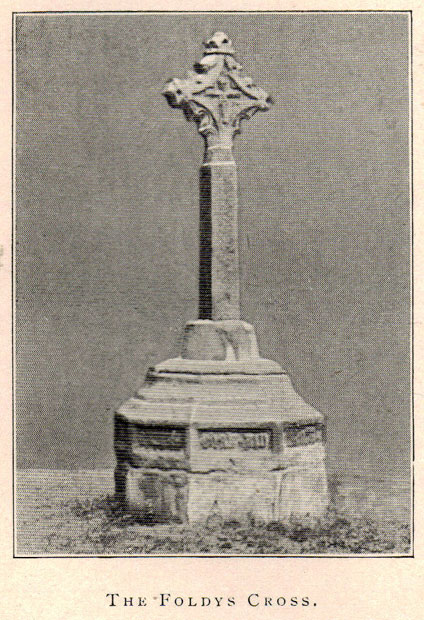
Foldys Cross, Burnley (Taylor, 1906)

Foldy’s Cross is a tall slender monument on a carved circular pedestal which sits upon a set of seven square-shaped steps. It dates from 1520 when it stood at the south side of St Peter’s parish church, Burnley. It was set up to commemorate a chaplain of St Peter’s church by the name of John Foldy or Foldys, and was then the town’s market cross or St Peter’s churchyard cross. In 1780 it was badly damaged by a Puritan mob, but the Towneley family rescued it and had it brought to their estate where it was repaired in a haphazard way and placed at the north-eastern side of the hall on the Avenue. In 1911 Burnley Borough Council had the cross completely restored for its Jubilee Year celebrations with various sandstone pieces added to replace sections of the cross including the plinth and set of seven steps – which are thought to be an exact copy of the original ones. The cross was then placed in its current position 300 metres to the south-east of Towneley Hall at an intersection of footpaths leading towards Todmorden road.

The original design of Foldy’s Cross was of the Gothic style which can be seen in the cross-head. It is made of sandstone and has an octagonal shaft with a moulded plinth with sunken panels. These panels contain lettering in the Gothic script. The cross-head is very nice with its decorated four arms, one of which is sunk into the shaft to support the head itself; this appears to be the original moulded head or cap with nicely carved emblems and fleurons on the collar – all typically Gothic in style. In the middle of the cross-head is a rather crude crucifix scene and on the other side the letters “IHS”. On the plinth the inscription reads in Latin:

‘Orate pro anima Johannes Foldys, capellani qui istam crucem fieri fecit Anno Domini MCCCCCXX’

— which when translated reads as, “Pray for the soul of John Foldys, chaplain who caused this cross to be made in the year of Our Lord 1520”.

The cross is now grade II listed and the English Heritage Building identity number is 467232.

References:

  1. Peace, Richard, The Curiosities of England – Lancashire Curiosities, The Dovecot Press Ltd 1997.
  2. Taylor, Henry, The Ancient Crosses and Holy Wells of Lancashire, Sherratt & Hughes: Manchester 1906.

© Ray Spencer, 2011


Emmott Cross, Colne, Lancashire

Cross:  OS Grid Reference – SD 888 401

Also Known as:

  1. Touch Cross

Archaeology & History

The Emmott Cross

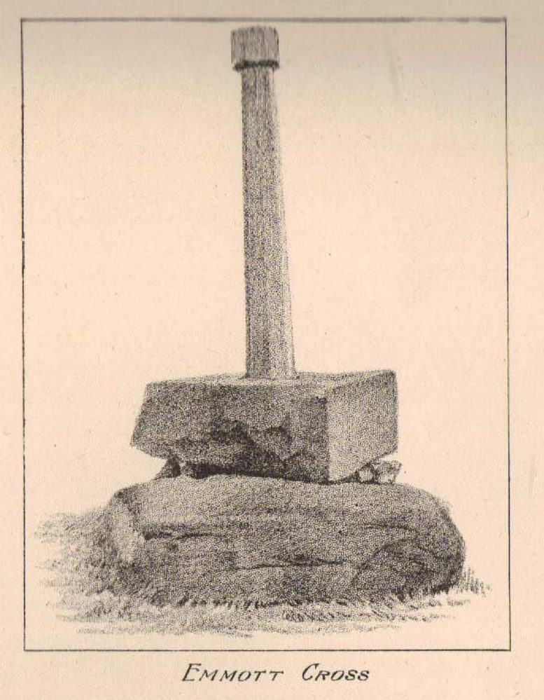
At the north side of St Bartholomew’s church-yard, Colne, stands the medieval Emmott Cross or Touch Cross. It was re-erected here in 1967 by local historian Mr Wilfred Spencer and a team of volunteers having being removed from the grounds of Emmott Hall, Laneshawbridge, when the old hall was being pulled down. The cross had stood for centuries close to the famous Hallown Well, both of which were highly venerated by pilgrims travelling between Whalley Abbey and Yorkshire. It appears that originally the cross had stood at the side of the Stanbury to Haworth road over Herders, close by Emmott.

The cross shaft stands 7 feet tall and is referred to as of the English Gothic style, probably 13th century. It stands in an octagonal socketed stone base which is 2 foot high and 4 foot square. Its slender octagonal shaft tapers away towards the top where there is a carved capital or corona – this may once have held a cross head or some other religious object. There used to be some faint lettering on the shaft but this has now worn away. A local historian Dr Whitaker described the lettering as “I.H.S.” along with the Greek omega symbol.

Taylor’s 1906 sketch

It was to all intent and purposes a preaching cross to which pilgrims would congregate and listen to the word of God and many would be baptised in the Hallown Well at the same time. In the penal times of the 16th century the cross was in great use, but by the 17th century it was being referred to as a “papist cross”.  During this period in history it suffered damage and the shaft broken in two places; the cross-head taken away and smashed. For safety reasons the cross-shaft was removed to Colne church-yard but returned to the grounds of Emmott Hall in 1728 when relative calm had returned.

The slender cross shaft and its hefty base are said to weigh about 2 tons and I have no doubt it does. It is now grade 11 listed.

Folklore

The name Touch Cross probably comes about in the sense that pilgrims touched the cross in the hope of a safe pilgrimage, or the name may be something to do with a troop of soldiers who were stationed at the hall in the past. They touched the stone too, but for different reasons – that they would live to fight another day in battle.

References:

  1. Byrne, Clifford H., “A Survey of the Ancient Wayside Crosses in North East Lancashire,” unpublished manuscript, 1974.
  2. Taylor, Henry, The Ancient Crosses and Holy Wells of Lancashire, Sherratt & Hughes: Manchester 1906.
  3. Whitaker, Thomas Dunham, An History of the Original Parish of Whalley and Honor of Clitheroe, Nichols, Son & Bentley: London 1818.

© Ray Spencer, 2011


Aiggin Stone, Blackstone Edge, Lancashire

‘Standing Stone’:  OS Grid Reference – SD 97329 17069

Getting Here

From Littleborough, take the Ripponden and Halifax A58 road up-uphill till you get to the White House pub near the very top.  From here, cross the road and walk  along the track below the disused quarry for a coupla hundred yards till you meet with the straight uphill track.  Go up here and, near the very top, you’ll see the upright stone right beside the footpath on your left.

Archaeology & History

Aiggin Stone and cairn

This ancient boundary stone has long been an etymological oddity.  It aint a prehistoric stone by any means (soz…), though its nature has never truly been decided for sure.  Some have posited it as Roman in origin, others that it’s merely a waymarker (in case y’ get lost in the fog up here), others that it’s a milestone, and the more common notion is that it’s a boundary marker of the counties of Yorkshire and Lancashire (it’s position in the landscape presently sits it in Lancashire).  As far as I’m concerned, the stone’s late-medieval in nature…

Standing by the old Roman road a short distance from the very top of these high Pennine hills on the Yorkshire-Lancashire border, a faint old Latin cross, plus the letters “I.T.” are etched onto its sides.  In the 1930s the stone was found laid in the moorland heather, but was thankfully resurrected in 1933.  Since then however, it’s been knocked over a couple more times, but presently stands proudly upright — until the day comes when some other halfwits decide to knock it down again!  In its earlier days, James Maxim (1965) described the stone thus:

“It is an irregular block of gritstone 7 feet long, tapering from 2 feet 6 inches to 2 feet wide and it is about 10 inches thick.  On one bedding face and a few inches from the top is an incised cross with the ends of the arms slightly expanded.  This is 1 foot 4 inches long and 10 inches wide, the horizontal bar crossing the vertical at about 5 inches from its upper end.”

Looking northeast

First highlighted on an engineer’s map from 1800, Herbert Collins (1950) assumes Aiggin to be “a corruption of Agger”, being a Latin word meaning, “a pile, heap, mound, dike, mole, pier – in Roman antiquity, an earthwork or other artificial mound or rampart.”  Due to the monolith’s proximity to the supposed Roman road there is great likelihood in it being as such, plus “agger” can also mean a Roman road or military way.  Collins cites other possibilities: aggerere, “to bear to a place, to heap up,” or “that which is gathered to form an elevation above a surface” – which is certainly applicable here!  James Maxim (1965) thought,

“The name ‘Aiggin’ suggests a pronunciation resembling either ‘edge’ or ‘hedge’ and thus it might mean ‘Edge Stone’. Alternatively it could be derived from the French ‘aguille’, meaning a needle or sharp-pointing rock.”

The view from here is truly excellent — though if you walk to the rocky crags of Blackstone Edge a half-mile to the south (y’ can’t miss ’em from here) and sit by Robin Hood’s Bed, it gets even better!  A smaller, possible standing stone can be seen just 200 yards northwest of our Aiggin Stone; with the top of the stone seemingly knocked off in bygone years. Not far from here are the remains of some old hut circles, emerging from beneath the old landscape.

References:

  1. Collins, Herbert C., The Roof of Lancashire, J.M. Dent: London 1950.
  2. Maxim, James L., A Lancashire Lion, J.L. Maxim Trustees: Leeds 1965.

Links:

  1. Ray Spencer on the Aiggin Stone

© Paul Bennett, The Northern Antiquarian 

Ratten Clough Cross, Emmott Moor, Lancashire

Cross Base:  OS Grid Reference – SD 93997 39746

Getting Here

Ratten Clough Cross stone

Follow the directions to reach the Herder’s Cross, not far away.  Standing on the Herder’s Cross stone, look across the fields to the north (away from the farmhouse on the hill below) and you’ll see a nice-looking stream a coupla hundred yards ahead of you.  Crossing this stream you see the large boulder, which you can see clearly if you’re stood on the Herder’s Cross.  That’s where you’re heading!

Archaeology & History

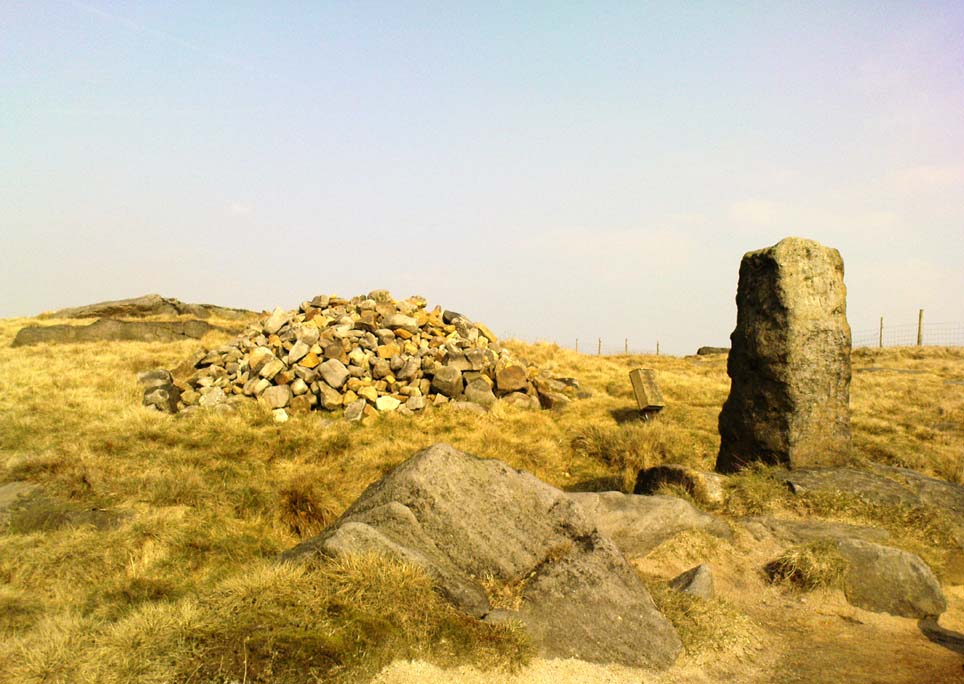
A curious entry inasmuch as I’ve found no other references to the place.  It’s an obvious cross-base, albeit very worn, cut onto the top of this large boulder, as you can see in the photo.  What may be a singular cup-marking (if you’re a New-ager, or work for English Heritage that is!) is on the western side of the rock — but without additional markings on the rock, this has gotta be questionable.

Dodgy cup-marking on top!
Shallow cross-base

The cut ‘square’ measures eight-inches both sides, but it seems that the cutting on the north-eastern sides of the base was never finished.  The depth of the cross-base is also very shallow, only an inch deep.  There seems to be a distinct possibility that this particular stone was initially chosen as a wayside cross marker, then for some reason perhaps moved to the position of the Herder’s Cross in the fields 420 yards (383m) to the south of here.

Clifford Byrne (1974) suggested that the pathway hereby was an ancient routeway that led towards the Emmot Holy Well, three-quarters of a half-mile down the hillside from here.  Any further info or thoughts on this side would be most welcome.

References:

  1. Byrne, Clifford, A Survey of the Wayside Crosses in North East Lancashire, unpublished manuscript, 1974.

© Paul Bennett, The Northern Antiquarian