Holy Well (destroyed): OS Grid Reference – TL 997 254
Archaeology & History
Near the centre of the ancient city could once be found the flowing waters of St. Helen’s Well. It was described many times in various legal and land documents from as early as 1331 CE onwards, in Colchester’s Oath Book. However, descriptions of the site itself and its curative abilities were not noted. It was simply associated with St Helen’s Chapel, whose original foundations date from the 12th century.
Folklore
One tradition told that it was St Helen herself who founded the chapel here. St Helen’s feast day is Agust 18.
References:
Benham, W. Gurney (trans.), The Oath Book; or, Red Parchment Book of Colchester, Essex County Standard: Colchester 1907.
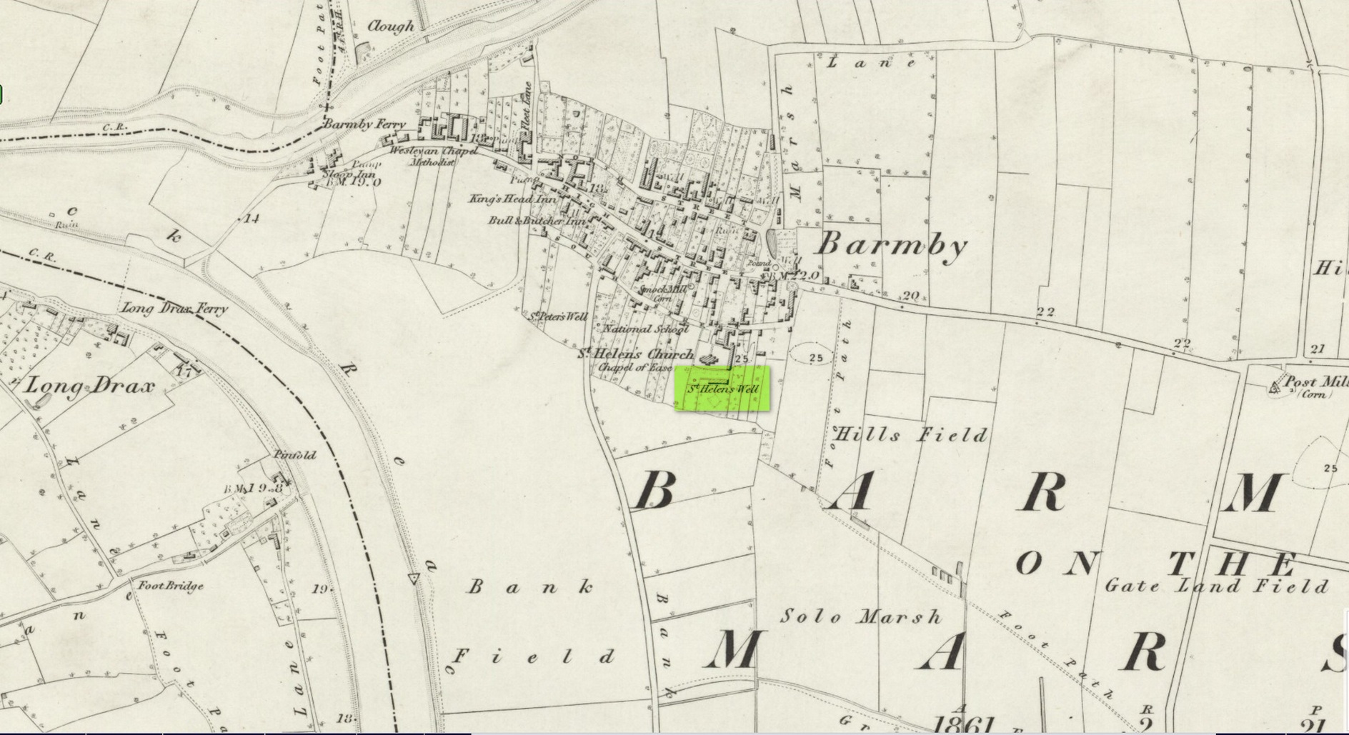
Holy Well (destroyed): OS Grid Reference – SE 6900 2841
Archaeology & History
Site shown on 1853 map
One of two holy wells in Barmby village which, like its compatriot St Peter’s Well, was destroyed sometime in the 19th century. Not good! It was located in the southwest section of the graveyard of St Helen’s Church and was apparently alive and running when the Ordnance Survey lads visited here in 1851 (as shown on their 1853 map). But when the site was revisited by them in 1905, it seems to have gone. However, as with the neighbouring St Peter’s Well, there are conflicting reports as to when it was destroyed, for although the Ordnance Survey lads spoke of it in the present tense when they went there, Thomas Allen (1831) told that “within the last six years (it has) been wantonly filled up.” Despite this, less than ten years later William White mentioned it in the present tense, also saying how it was “said to possess medicinal properties.” These healing qualities were, according to Allen, due to its iron-bearing or chalybeate nature, meaning that it would revive a weak and feeble constitution. Iron-bearing wells are damn good for such things!
As the years passed, St. Helen’s Well fell into folk memory. When William Smith (1923) surveyed the many holy wells in this part of the world he found how “old parishioners have said that as school-children they both drank of and washed in its water”, but little else.
References:
Allen, Thomas, A New and Complete History of the County of York – volume 2, I.T. Hinton: London 1831.
Gutch, E., Examples of Printed Folk-lore Concerning the East Riding of Yorkshire, Folk-Lore Society: London 1912.
Harte, Jeremy, English Holy Wells – volume 2, Heart of Albion press: Wymeswold 2008.
Smith, William, Ancient Springs and Streams of the East Riding of Yorkshire, A. Brown: Hull 1923.
White, William, History, Gazetteer and Directory of the East and North Ridings of Yorkshire, R. Leader: Sheffield 1840.
Holy Well (destroyed): OS Grid Reference – TQ 102 952
Archaeology & History
A long lost sacred site (not to be confused with the nearby Bright Well) that has given its name to the district of Holywell. It also gave its name to an early farmstead; and to the place-name of Holywellane recorded as far back 1485. It was also described as a “Holy Well” in a local vestry book in 1698. Nothing more seems to be known of the place.
References:
Gover, J.E.B., Mawer, Allen & Stenton, F.M., The Place-Names of Hertfordshire, Cambridge University Press 1938.
Harte, Jeremy, English Holy Wells – volume 2, Heart of Albion press: Wymeswold 2008.
Holy Well (destroyed): OS Grid Reference – TL 2214 0449
Archaeology & History
An early reference by Nathaneal Salmon (1728) told that in the grounds of St. Mary’s church by the vicarage there was a well, which may or may not have been deemed as ‘holy’. He wrote:
“There is a Dale in Coppice belonging to the Manor of Potterels, from which, after a great Quantity of Rain, the Water comes through Veins of Chalk to the Vicarage Well, and is white.”
No well is shown on the early OS-maps at this place and we can only assume that it was either capped or had fallen back to Earth not too long after Salmon’s visit.
References:
Salmon, N., The History of Hertfordshire; Describing the County and its Monuments, London 1728.
Acknowledgements:Huge thanks for use of the Ordnance Survey map in this site profile, reproduced with the kind permission of the National Library of Scotland.
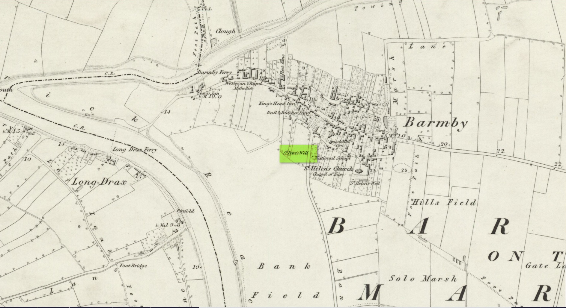
This holy well was one of two in the village of Barmby, neither of which seems to exist anymore — although, it has to be said, there are conflicting reports as to its demise from the word go. When it was first mentioned in Thomas Allen’s (1831) huge work on the history of Yorkshire he told us that,
“In this village are two extraordinary springs of sulphuric and chalybeate water, denominated St Peter’s and St Helen’s; the former possesses the rare virtue of curing scorbutic eruptions by external application. Both of these wells, within the last six years, have been wantonly filled up, and the site is only known to a few of the villagers.”
Their “extraordinary” waters however, were apparently found to be still flowing when the Ordnance Survey lads surveyed here in 1849, as they published it a few years later on the 1853 OS-map of the region, along with its nearby compatriot of St Helen.
Wet patch on 1907 mapSt Peters Well, Barmby 1853
Less than ten years earlier, Will White (1840) also spoke of St Peter’s Well, albeit briefly, telling that it “was said to possess medicinal properties”—but it seems that he never visited the site and was merely going on Mr Allen’s earlier description. Its exact whereabouts however, is somewhat of a curiosity. Although the Ordnance Survey lads mapped it as being SE 6885 2848 on the southwest side of the village, in William Smith’s (1923) survey of holy wells he gave us a very different location. “St Peter’s Well,” he wrote,
“is situated in an orchard about a hundred yards to the south-east of the church, and is reached by going through three fields. It is a pool about eight feet deep and fifteen in diameter, the spring now rising several yards from its original site. It flows clear and strong, and though attempts have been made to block it up, it always reappears. The water is soft and has never been known to freeze. It contains sulphur, as I can testify, having tasted the water. It is noted for curing scurvy and sore eyes, if applied externally, and half-a-century ago, people suffering from these ailments came long distances to apply the water as a remedy, and went away benefited. An eye-witness has said a man living far from Barmby, advised by his medical man, as a last resort visited the well and applied the water externally for the cure of scurvy, and so quickly did he lose the scales that fresh sheets for his bed were required each night…
“About a century ago, the owner of the orchard in which the well is situated had a son, a doctor, who commenced to practice in the district. The owner’s wife looked upon the spring as detrimental to the prospects of the son. So she said to her husband, “Tummus, we’ll hev that well filled oop. Foaks can cure thersens, an’ ther’ll be nowt fur poor Tummy ti dea.” Tummus was so convinced by his wife’s foresight that he did as she wished, and filled up the well.”
Naathen, on the very first OS-map of the village, the lads marked it at SE 6885 2848, as well as on subsequent surveys. This spot is 170 yards west of the village church wall. The location described by Smith has no “well” or spring marked on any maps, but, on the 25-inch scale map, 100 yards southeast of the the church walling we see marshland on the other side of a copse of trees in the very spot he told us about. Whether or not this was the actual spot, or whether the OS-lads had it right, we might never know. Field-name surveys may help; the existence and location of the orchard may help; other literary accounts might also be useful. But, one final query that may be important relates to Tom Allen’s (1831) words when he told us that “the site is only known to a few of the villagers.” By that, did he mean that the local folk kept its position quiet from outsiders? Even today, in our numerous inquiries with local people in the glens and mountains when seeking out lost or forgotten places, we still come across some olde local folk who are still quite hesitant, with that serious quizzical look in their eyes…
Folklore
St Peter’s day was celebrated on June 29. He was one of the so-called “major saints” due to him being one JC’s Apostles. His symbol was a key.
References:
Allen, Thomas, A New and Complete History of the County of York – volume 2, I.T. Hinton: London 1831.
Gutch, E., Examples of Printed Folk-lore Concerning the East Riding of Yorkshire, Folk-Lore Society: London 1912.
Harte, Jeremy, English Holy Wells – volume 2, Heart of Albion press: Wymeswold 2008.
Smith, William, Ancient Springs and Streams of the East Riding of Yorkshire, A. Brown: Hull 1923.
White, William, History, Gazetteer and Directory of the East and North Ridings of Yorkshire, R. Leader: Sheffield 1840.
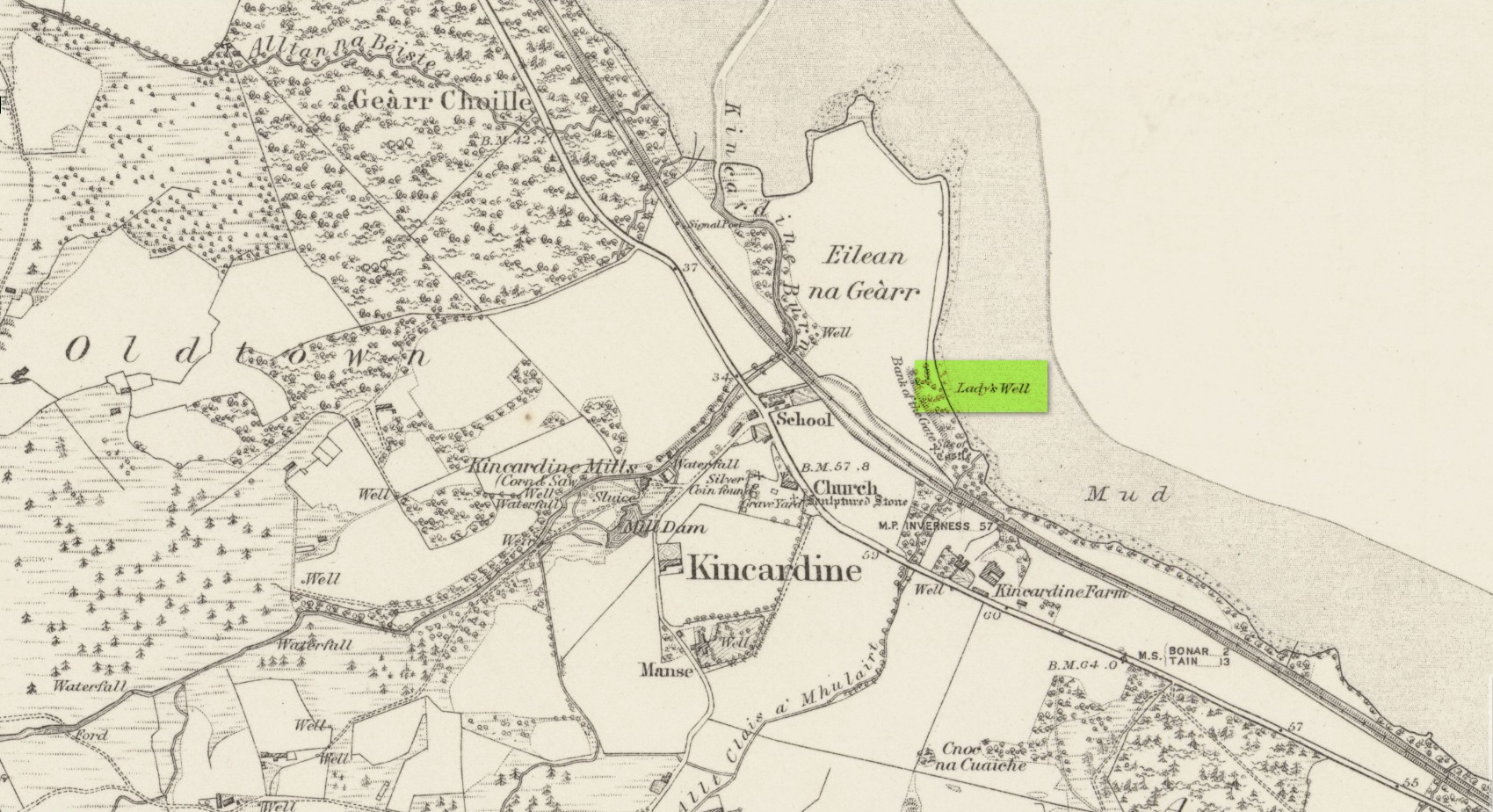
Holy Well (lost): OS Grid Reference – NH 6072 8954
Archaeology & History
Site shown on 1879 map
First highlighted on the 1879 Ordnance Survey map, information on this site is sparse, save for those reliable Statistical Accounts and Name Books, which simply give us its location. The only context that our Old Statistical lads gave us was its relationship and proximity to a castle, “the most ancient residence” of the Clan Ross Highland Chiefs which could “be seen in a beautiful field between the church and the sea side.” At the end of this field is “a steep bank, hanging over the sea at high water called the ‘Bank of the Gate’, and at the bottom there is a spring of excellent water, called the Lady’s Well.”
The water’s dedication to Our Lady was obviously grafted onto it by those in the church above, glossing over, no doubt, earlier dedications by local people, whose practices seem to have been lost. The site was included in the regional Name Book of the Ordnance Survey doods who, it seems, merely copied the notes about the place from the old Statistical Account. In what seems to have been their last visit, no trace of the well was evident. They concluded it “was under water at time of visit.”
It would be good to hear from local folk if this sacred site can still be found at the tree-line just above the sea, or whether Nature has taken it away from Her animals.
Acknowledgements: Big thanks for use of the early edition OS-map in this site profile, Reproduced with the kind permission of the National Library of Scotland.
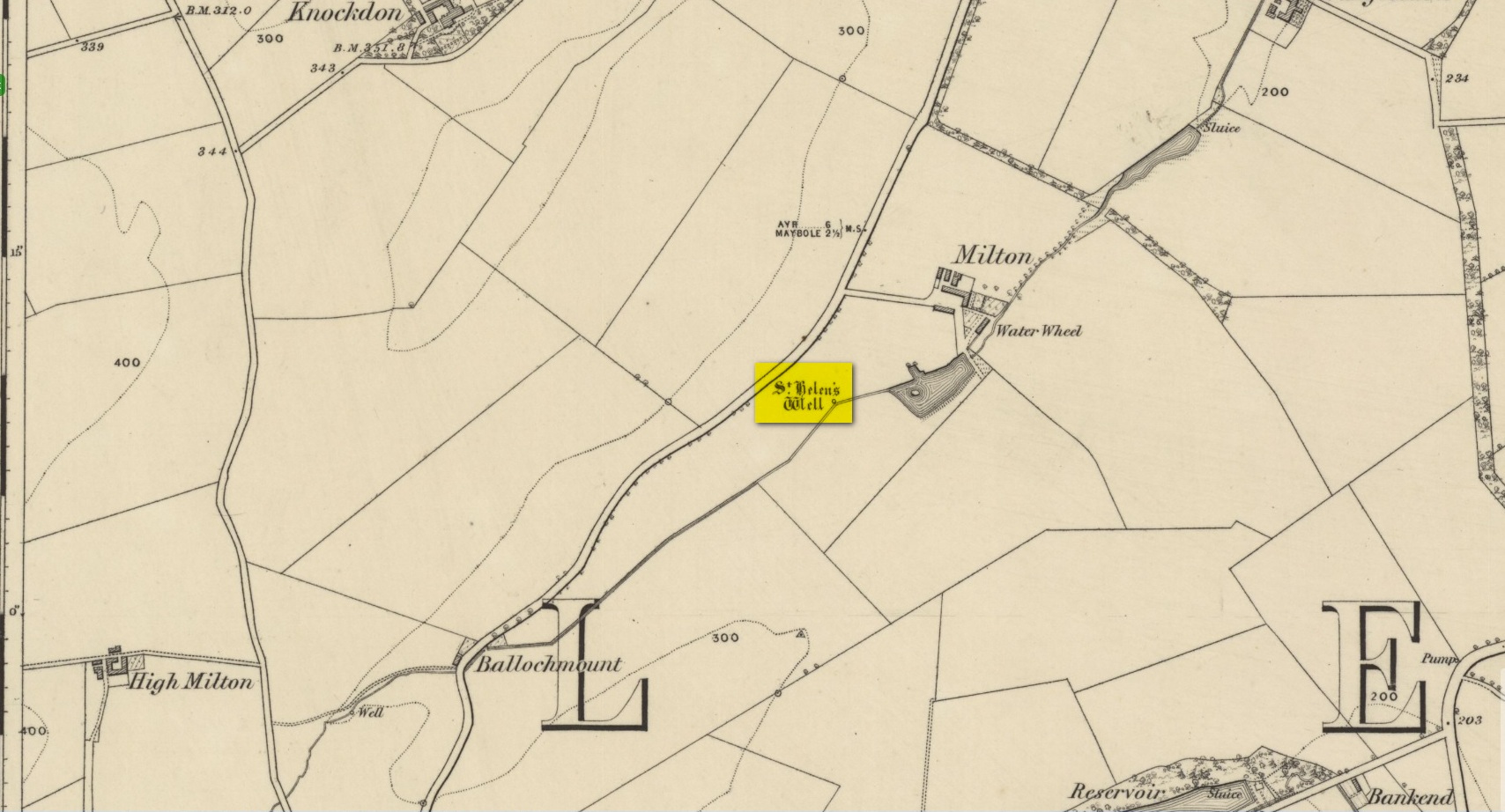
In spite of this site being covered over some time in the 1950s, it is still retained on the modern Ordnance Survey maps. It was shown on the first one in 1860, but its literary history goes back much further. We find it described by the Minister for Maybole — one William Abercrummie — in his short 17th Century work named A Description of Carrict. He noted several springs in Maybole township, with this one of possessing the usual hallmarks of both christian and peasant customs alike:
“Another spring there is called St. Helens well or by a curt pronuntiation St. Emus for St. Antonies well, it is about a myle and ane halfe from Mayboll on the road to Aire a litle north of Balachmont. It is famous for the cure of unthriving children, to which at the change of the quarter especially at May-day there is a great resort of people from all quarters, and at a good distance.”
This piece was repeated in several 19th century works, including one by William Roberston (1891), who commented on the traditions themselves, saying:
“This can unquestionably be traced as a remnant of the ancient superstition that miracles were wrought at Holy Wells; which all the anathemas of the Reformed Kirk could not for a time obliterate from the minds of the common people. The records of the Kirk-session bear witness to the prevalence of applying to Saints’ Wells for the cure of bodily infirmities on stated occasions; particularly, when the Saint or Angel was understood to ‘move the waters.’ Pins, pieces of the dress of the patient, or such small trifles, were left at the well – the remains, no doubt, of the offerings formerly made to the Clergy – and in token that the disease was transferred from the sufferer to the rags, thus offered to the Genius loci. Numerous traces of this prevailing superstition could easily be cited.”
When the Ordnance Survey dudes wrote about the site in the Name Book in 1857, all they could tell us was that it was, “a beautiful spring of excellent water” but was said to have “no medicinal properties.”
Despite this sacred well now being covered over, there is surely a case to be made here for it to be restored back to its former glory, for all to visit and see. Local historians, pagans and Christians alike — join forces and gerrit sorted!
References:
MacKinlay, James M., Folklore of Scottish Lochs and Springs, William Hodge: Glasgow 1893.
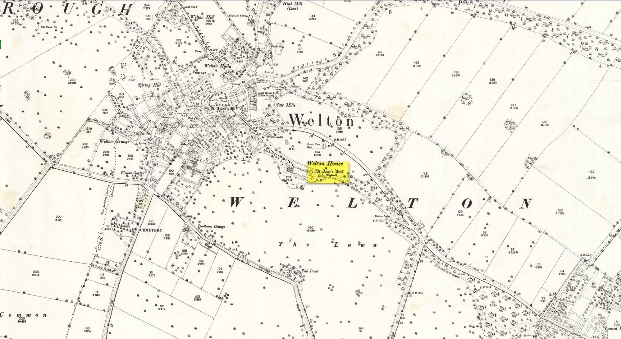
Shown on the early 25-inch-to-the-mile Ordnance Survey map of the area, this is a frustrating site. In Thompson’s (1870) early history of Welton village, he says very little about this place, other than:
“Then there is Saint Ann’s Well, which supplies Welton House with spring water.”
Site shown on 1890 map
Even worse is the fact that in William Smith’s (1923) survey of East Yorkshire holy wells, he merely copies Thompson; and in Jeremy Harte’s magnum opus he does exactly the same thing! Not good. Thankfully the local artist and singer, Gaynor Perry, helped us out big time! She grew up in this area and used to play here when she was young, but at the time she had no idea that the well where she’d played had any magical traditions attached to it. This discovery happened many years later. Regarding the present condition of the well (as of 2017), she told:
“The well has been covered with stone slabs for a long time (and) a tree has tried to grow over it. It has been sheltered here over the years in the grounds of Welton House, a large estate which was demolished in 1952.”
The well can still be seen in the small copse of trees immediately north of St Anne’s College. There is the possibility that this holy well gave its name to the village of Welton itself. First mentioned in 1080 CE, the place-name means “the well near the farm,” (Smith 1937) although there is no direct linguistic association with St. Anne, so we don’t know for sure.
Folklore
St. Anne is a curious saintly figure and one of my personal favourites. St Anne (saint’s day – July 26) was a giant in early christian and Islamic myths. An apocryphal figure, She was the Great Mother of the mother of Christ—the Virgin Mary—and was Herself a Virgin until, in Her old age, after seeing a bird feeding a chick, decided She wanted a child and so eventually gave birth to Mary. An old woman giving birth when the Springtime appears (when birds and other animals become fertile) is the same motif found in the lore of the Cailleach in Ireland and Scotland (and parts of northern England). A pre-christian mythos was obviously at play here in bygone times…
Holy Well (lost): OS Grid Reference – SP 66 59 (approximate)
Archaeology & History
In George Baker’s (1822) massive regional history work he spoke of the village being “well supplied with springs, one of which, called Holywell, is medicinal.” But it would seem to have fallen foul of that thing called progress, as no one has spoken of it since then. When the Northampton historian, Beeby Thompson, looked for the site early in the 20th century, his enquiries drew a blank and he reported simply that “at the present time no one in the village appears to know of such a well.” A field-name survey of the area may prove worthwhile…
References:
Baker, George, The History and Antiquities of the County of Northampton, J.B. Nichols: London 1822.
Very little is now known about this sacred site that was once found “a few hundred yards east from the New Church at Low Harrogate.” (Hunter 1830) Even most of travellers and medical experts who wrote about the numerous Harrogate wells in the 18th and 19th century bypassed its quietude; and by the time Mr Hunter wrote about it in his great descriptive catalogue, its healing or medicinal qualities had been forgotten.
He told that “the spirit in the water…or that with which it is infused, has long been most actively engaged in adding real or fancied comforts to the (Harrogate) Fair, and is now in much more general use” than the two other holy wells in the town. It was, he said, “the best water for making tea and more extensively used for that purpose than any in the neighborhood of Harrogate.” It would also appear to have been built over at some time in the not-too-distant past…
Folklore
St Ann (saint’s day – July 26) was a giant in early christian and Islamic myths. An apocryphal figure, She was the Great Mother of the mother of Christ—the Virgin Mary—and was Herself a Virgin until, in Her old age, after seeing a bird feeding a chick, decided She wanted a child and so eventually gave birth to Mary. An old woman giving birth when the Springtime appears (when birds and other animals become fertile) is the same motif found in the lore of the Cailleach in Ireland and Scotland (and parts of northern England). Pre-christian lore at this old well would seem evident here.
References:
Hunter, Adam, The Waters of Harrogate and its Vicinity, Langdale: Harrogate 1830.