Idol Stone, Ilkley Moor, West Yorkshire

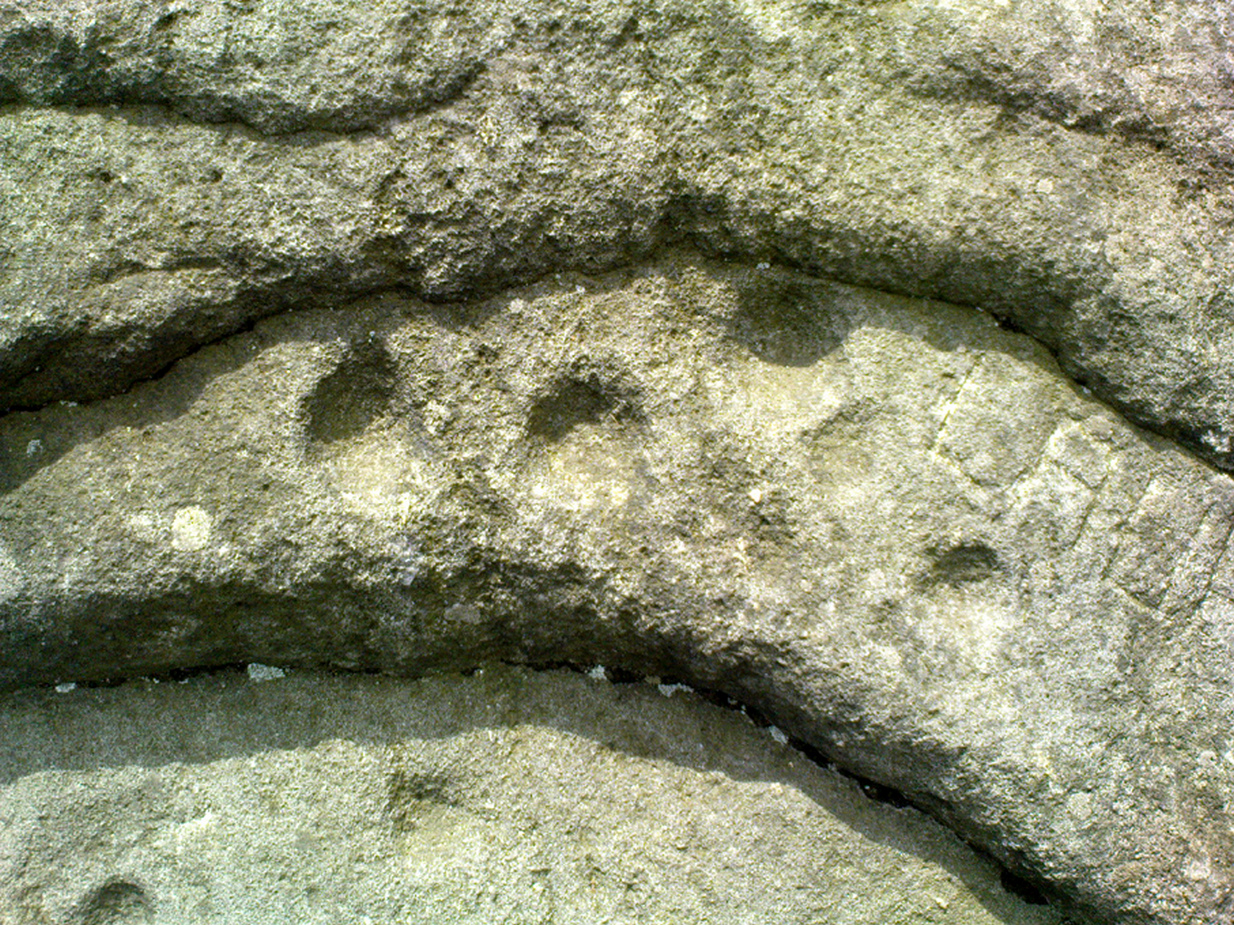
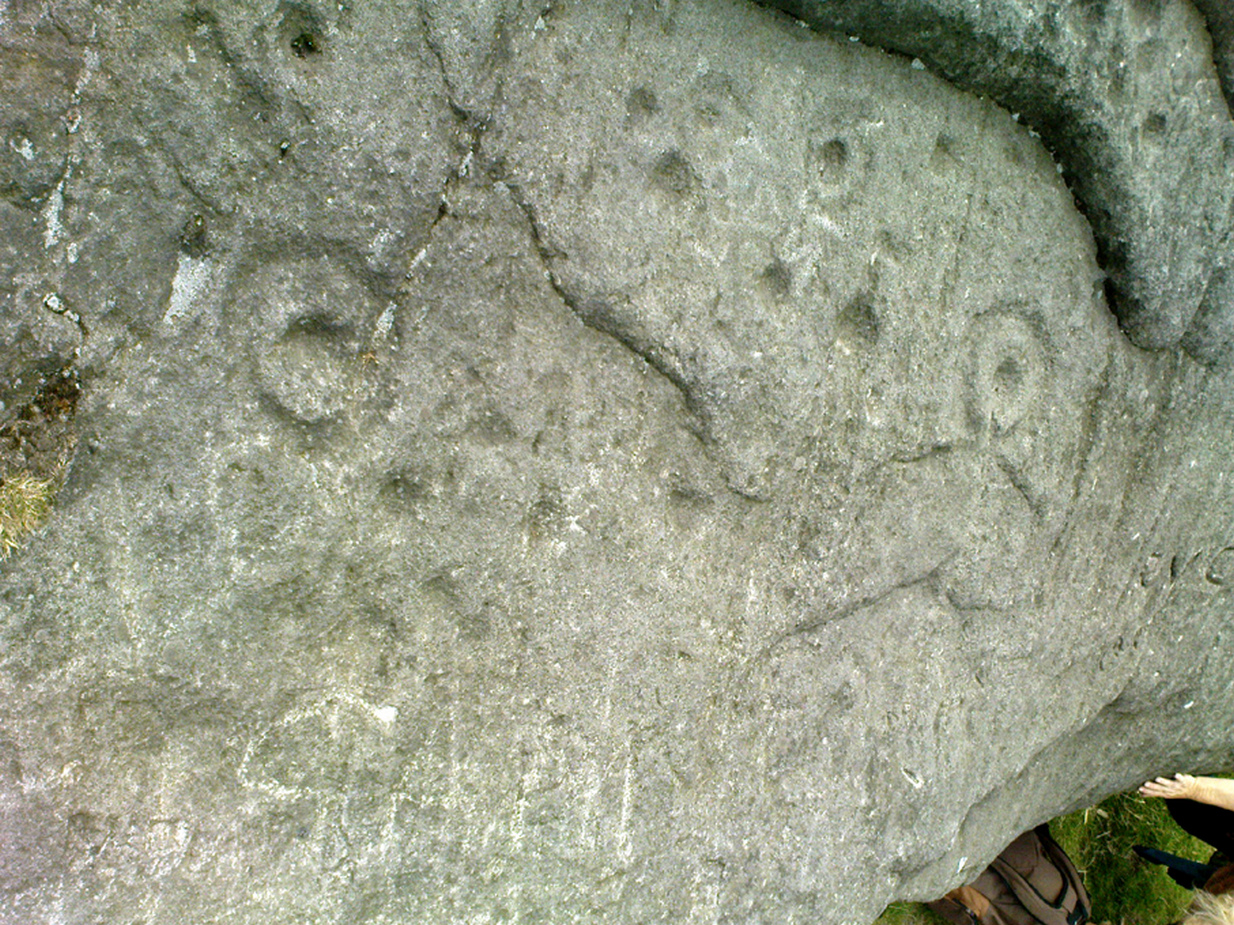
Cup-and-Ring Stone:  OS Grid Reference – SE 13265 45943

Also Known as:

  1. Carving no.322 (Boughey & Vickerman)
  2. Carving no.157 (Hedges)

Getting Here

Idol Stone carving (Allen 1882)

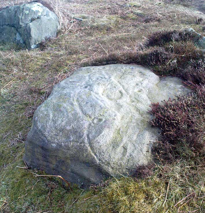
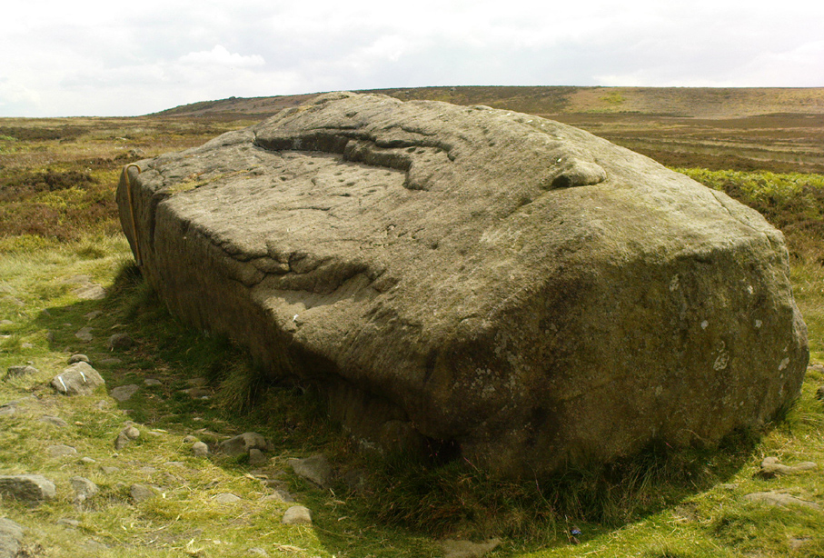
Take the directions to reach the Haystack Rock, then head onto the moor following the southeast footpath for a few hundred yards, towards where the moor slopes uphill.  20-30 yards before the uphill slope, a yard to the right of the path.  It accompanies the Young Idol Stone with its two small cups, just a few yards away.  Keep your eyes peeled and y’ can’t really miss it! If you hit the large slightly-pyramidal-shaped boulder with its well-worn lines running from its top (the Idol Rock), you’ve gone past it.

Archaeology & History

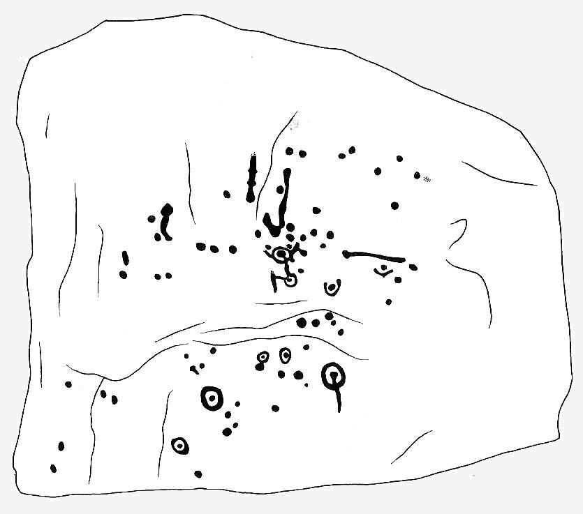
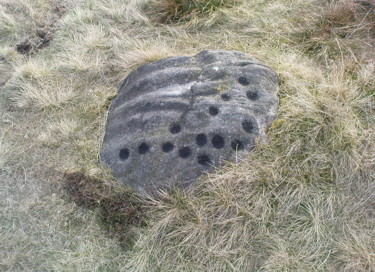
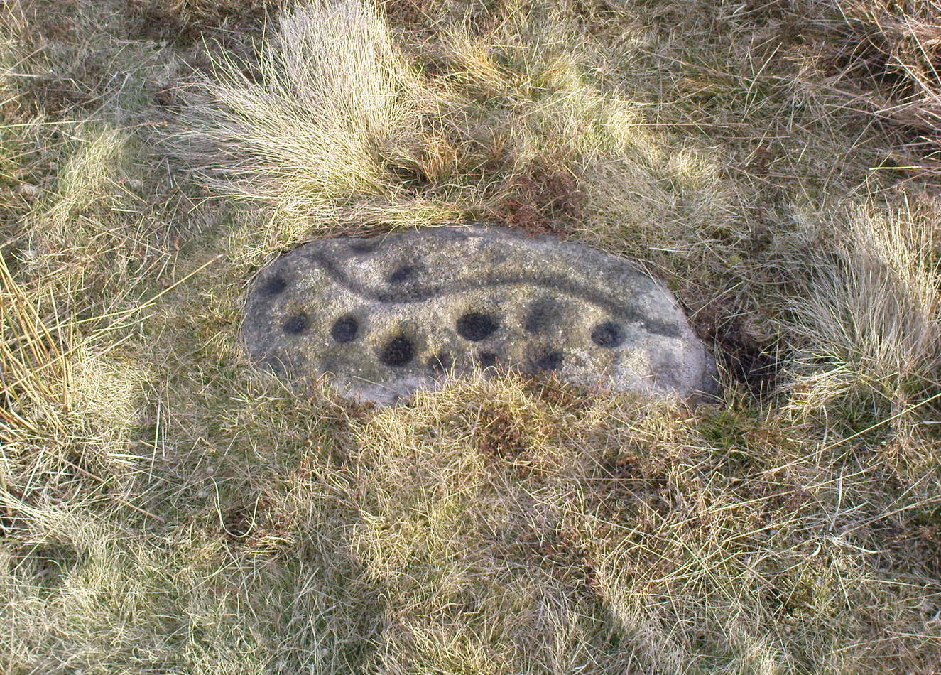
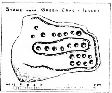
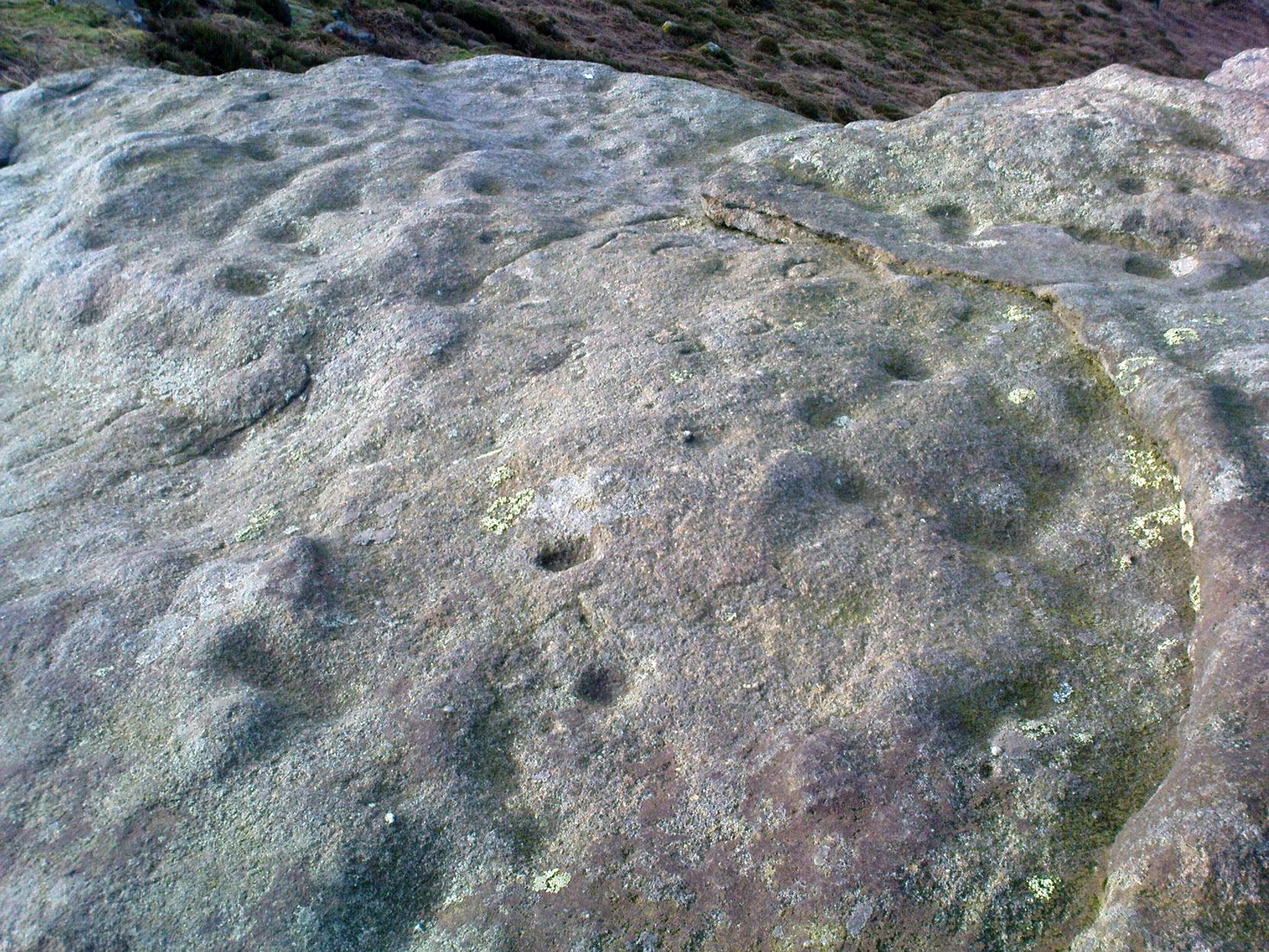
An intriguing carving this, and one which has always had me edging towards a manifest linear or logical myth underscoring its form.  It’s the almost binary or primal numeric system in the lay-out of the cups which seems to do it.  Few other carvings in the region exhibit this tendency.*  If you aint seen it ‘in the flesh,’ check it out.

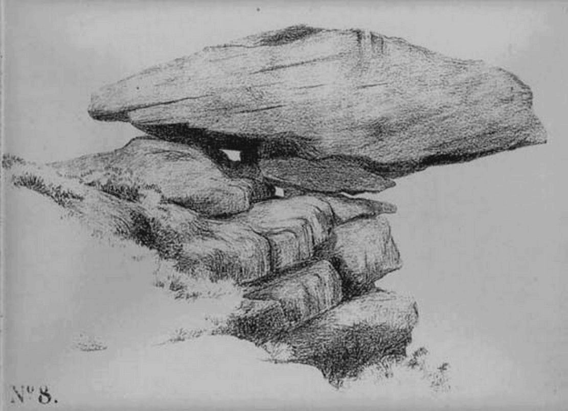
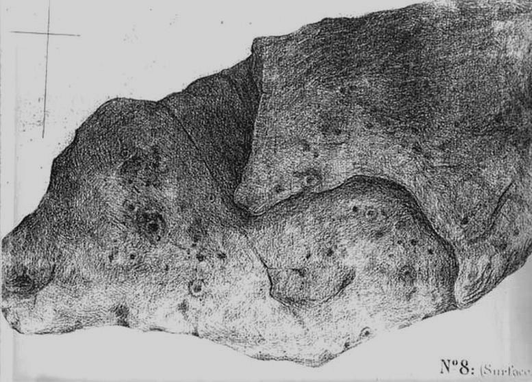
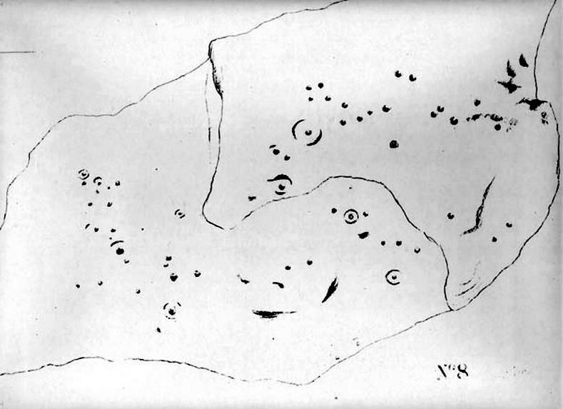
First described by that old Victorian J. Romilly Allen (1882), he seemed equally impressed by it, calling it “the most beautiful specimen of prehistoric sculpture,” continuing:

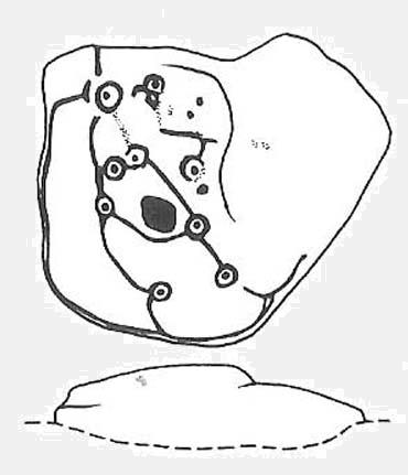
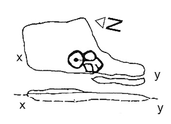
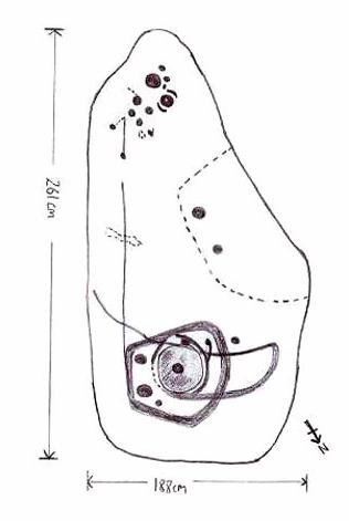
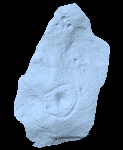
“The stone is of grit, and measure 3ft 2ins, by 2ft 6ins.  Its upper surface is nearly horizontal, and has carved upon it cups varying in diameter from 2ins to 3ins.  A row of cups in the middle of the stone are entirely surrounded by a groove.  There is also a channel running round the outside.  Single cups are often found encircled by one or more concentric rings; but it is very exceptional indeed to find several cups surrounded by a single groove, or to find the cups so symmetrically arranged as in the present instance.”

Idol Stone - looking SW
Idol Stone – looking SW

Prehistoric walling runs very close to this and the adjacent rock carvings, with the well-known ‘enclosure’ just a short distance to the east on the same moorland plain.  This carving is very much on the edge of, or within, Green Crag Plain’s ‘Land of the Dead.’

This carving was one of several that Alan Davis (1983) measured in his exploratory survey on the validity of Alexander Thom’s ‘megalithic inch’ unit.  This issue absolutely fascinated me as a boy, as it brought the attention of these curious non-linear images into the domain of mathematics and the higher sciences, instead of the lowly social sciences within whose domain archaeology is embedded, with its many inaccuracies and falsehoods.  A number of astronomers and other academics did a great number of papers exploring potential units-of-length, surveying the carvings (and megalithic rings) in much greater detail than any previous archaeologist.  Much of it was excellent work.  However, the mythos of our ancient ancestors possessing great technical knowledge and mathematical ability was unfounded.  In Davis’ (1983) paper — edited and expanded a few years later (1988) — he found no evidence of mathematical units of measurement here; though left the option ‘open’ for further discussion and analysis on several others, where multiple units of megalithic inches were measured.  These findings however, are more likely the result of mere chance.

Idol Stone with “21st century informal unauthorised” art added

In 2011 some unnamed people visited the Idol Stone carving and vandalized it (this sadly happens more and more up here); but this form of vandalism is now being termed “twenty-first century informal unauthorised carvings” and is actually sanctioned by Ilkley Parish Council members, local businessman Tom Lonsdale and his affiliates as artistic “tradition”!  Indeed, the damage done here and vandalism done on some other ancient carved stones that have been redesignated by Tom Lonsdale and friends as “twenty-first century informal unauthorised carvings”, legitimizes and encourages others to follow in their shallow-minded ignorance, enabling others to add their own form of ‘art’ on these supposedly protected monuments, on a region with an alleged SSSI status. They even encourage supposedly ‘nice’ people — y’ know the sort — to etch poems and such things onto the stones on the moors, in violation of regulations that apply to the general public.  As a result, expect more vandalism — sorry…arty “twenty-first century informal unauthorised carvings” both here and elsewhere.  This same appalling debacle — sorry, “tradition” — has been encouraged on the Haystack Rock, Hanging Stones and other prehistoric carvings on the moor.

Folklore

The name ‘Idol Stone’ was an invention of one of the Victorian romanticists, who saw heathen idolatry and perversion all over these moors (you’ve gotta ask y’self, what the hell were these people up to!?).  Our old friend Nicholas Size (1934) told there to have been ghostly figures and druidic activities occurring at this site.

References:

  1. Allen, J. Romilly, ‘Notice of Sculptured Rocks near Ilkley, with some Remarks on Rocking Stones,’ in Journal of the British Archaeological Association, volume 38, 1882.
  2. Boughey, Keith & Vickerman, E.A., Prehistoric Rock Art of the West Riding, West Yorkshire Archaeology Service 2003.
  3. Cowling, Eric T., Rombald’s Way, William Walker: Otley 1946.
  4. Davis, Alan, ‘The Metrology of Cup and Ring Carvings near Ilkley in Yorkshire,’ in Science and Archaeology, 25, 1983.
  5. Hedges, John, The Carved Rocks on Rombalds Moor, WYMCC: Wakefield 1986.
  6. Hotham, John Paul, Halos and Horizons, Hotham Publishing: Leeds 2021.
  7. Jennings, Hargrave, Archaic Rock Inscriptions, A. Reader: London 1891.
  8. Size, Nicholas, The Haunted Moor, William Walker: Otley 1934.
  9. Speight, Harry, Upper Wharfedale, Elliott Stock: London 1900.

© Paul Bennett, The Northern Antiquarian 


Pancake Stone, Ilkley Moor, West Yorkshire

Cup-and-Ring Stone:  OS Grid Reference – SE 13404 46228

Also Known as:

  1. Carving no.167 (Hedges)
  2. Carving no.332 (Boughey & Vickerman)
  3. Pancake Rock

Getting Here

Pancake Stone, Ilkley Moor

We were up here again the other week: wind, hail and snow blowing like hell, thankfully keeping the place to ourselves! To get here, head up Cow Pasture Road from the train station and up to the Cow & Calf Hotel near the famous rocks.  Go past it a 100 yards or so and then look uphill onto the moors ahead of you.  You’ll see a great over-hanging rock on the slope above you which looks as though its may fall down at any moment. That’s the Pancake Stone!  Either walk up the steep path to get there quickly, or the longer route by taking the sloping diagonal path that runs eastwards until you’re on the same level.

Archaeology & History

Site shown  on 1851 map

Highlighted on the first Ordnance Survey map of the region in 1851, this prehistoric carved stone had been known as the Pancake Stone by local people long before any antiquarians gave it their literary attention to the place.  It would have had tales told of it, no doubt, but they were never written down.  It’s an impressive, some would say precarious piece of rock: an elongated thin wedge of stone resting gently on the cliff edge, much like a rocking stone to be honest, seemingly hanging onto the edge of the geological ridge awaiting its fall down the slope; but that’s not gonna happen for many more centuries yet.

J. Thornton Dale’s 1879 drawing

Much has been written about the petroglyph on the this wedge of stone, which covers much of its surface.  Although a Mr J. Thornton Dale did a fine series of quite accurate drawings of this stone (and others on the moors) between 1878 and 1880, the first literary description of the Pancake rock carving appears to have been by the renowned J. Romilly Allen in 1882 (who evidently visited the stone on a cloudy or overcast day), saying that:

“On its upper surface are several cup-markings much obliterated by the actions of the weather, but some of them sufficiently distinct to prove their origin artificial, and to show that this rock was noticed in ancient times, and very possibly considered an object either of worship or superstition.”

Close-up of cups & rings
Close-up of CnRs
Looking across the stone

This latter assumption is highly probable.  Strong animistic notions (moreso than usual) would be very evident here.  Its position on the land with its outward focus from here towards other notable points in the landscape (Almscliffe Crags is one obvious focus); as well as looking at the rock itself from other viewpoints, give the stone considerable ritual importance.  Sections of the moorland plain behind it—known as Green Crag—was the Land of the Dead in ancient times, and it is more than likely that death rites would have been enacted here — though we may never know what form they took.

Dale’s 1879 sketch

The stone has what seems to be at least 54 cup-markings on its upper face, with numerous grooves meandering and connecting other points.  In J. Thornton Dale’s 1879 drawing of the upper surface, you will note that a couple of the rings he included have all-but faded away and are not included in the more recent surveys.  Of the primary design, rock art students Boughey & Vickerman (2003) described there being “six complete and five partial rings” amidst the morass, but much of the design is very worn and, originally, there was probably a bit more to it all.  The rock upon which the main Pancake Stone rests also has some worn cup-marks etched on its surface, a couple of which can be made out in the top photo.

Folklore

Good old Nicholas Size (1934) added this site to his list as a place where he had visions of the old christian cult, upon whose bare face were enacted blood rites and sacrifice.  One Beltane Eve when he decided to amble up onto the moor edge, he could see a strange glow coming from behind the rock.  He continues:

“Then suddenly I noticed there was a figure dancing upon it.  The figure seemed to swirl round and round with floating draperies, grey or white, and I can only say that it looked very uncanny.  Stupidly, I wondered that anybody could be such a fool as to dance in the darkness upon that precarious footing…”

But such activities on these moors, at certain times of the year, have been enacted for many centuries.  It’s just kept quiet and, as more modern pagans (as they like to call ’emselves) keep coming up here and to other places, so the original folk move to their older and increasingly more secluded spots…  In the latter half of the 20th century the site was used as a focus by chaos magickians, shortly after the inception of that Current.

References:

  1. Allen, J. Romilly, ‘The Prehistoric Rock Sculptures of Ilkley,’ in Journal of the British Archaeological Association, volume 35, 1879.
  2. Allen, J. Romilly, ‘Notice of Sculptured Rocks near Ilkley, with some Remarks on Rocking Stones,’ in Journal of the British Archaeological Association, volume 38, 1882.
  3. Boughey, Keith & Vickerman, E.A., Prehistoric Rock Art of the West Riding, West Yorkshire Archaeology Service 2003.
  4. Cowling, Eric T., Rombald’s Way, William Walker: Otley 1946.
  5. Hedges, John, The Carved Rocks on Rombalds Moor, WYMCC: Wakefield 1986.
  6. Jennings, Hargrave, Archaic Rock Inscriptions, A. Reader: London 1891.
  7. Size, Nicholas, The Haunted Moor, William Walker: Otley 1934.
  8. Speight, Harry, Upper Wharfedale, Elliott Stock: London 1900.

© Paul Bennett, The Northern Antiquarian


Haystack Rock, Ilkley Moor, West Yorkshire

Cup-and-Ring Stone:  OS Grid Reference – SE 13027 46310

Also known as:

  1. Carving no.141 (Hedges 1986)
  2. Carving no.302 (Boughey & Vickerman 2003)
  3. Cottage Rock

Getting Here

The Haystack Rock
The Haystack Rock

Dead easy to find this one!  Get to the Cow & Calf Hotel and walk up the slope onto the moor ahead of you.  If you want a direction-pointer, head for the large, seemingly overhanging rocks which are the Pancake Stone, at the top of the ridge, but a few hundred yards to the right (west).  Once you reach the level on the moor proper, you’ll see this large haystack-shaped boulder close by.  That’s it!

Archaeology & History

This tends to be one of the spots I stop at when doing my tourist walks, to i) let folk get their breath back after ambling from the car park, via Hanging Stones and Map Stone; ii) to drink in the view, and, iii) to begin acquainting themselves with the landscape as it was when this stone was carved (over many decades, perhaps longer), and the animistic cosmology underlying people’s notions of their land.  It can be quite an education…

Haystack Rock, with crushed man underneath
Haystack Rock crushes local man
Fertility symbol, or Rorschach response?

The Haystack Rock was a very important boulder in the mythic landscape on this plain. It stands near the western end of the Green Crag Necropolis: a huge area of land on these moors where, quite simply, the people of these hills laid their dead.  Effectively, the Haystack Rock stands on the edge of Ilkley Moor’s “Land of the Dead”.*

Highlighting this quite firmly, we find that prehistoric walling ‘separates’ this great boulder from the other part of the Plain close to its east and southern sides (walling on its western side is as yet unproven).  It was a boulder that was specifically sectioned-off, away from any tombs.  All along this Plain are numerous small cairns, many with rock-art nearby, and certain parts of the Plain are split into sections by ancient walling (though a precise map of the walling, tombs and rock-art on this moorland ridge has yet to be done).

J.Romilly Allen's 1879 images
J.Romilly Allen’s 1879 images

As far as the textbooks are concerned, we find the first mention of this great carved boulder came from J. Romilly Allen at the end of the 1870s.  By 1900, a number of people had been here and written of its grandeur; but, as with cup-and-rings in general, its non-linear form and design elicited the usual notions of bewilderment, druids and puzzled ideas.  Much like today really!

Drawing of the central design (after Hedges, 1986)
Drawing of the central design (Hedges, 1986)

But this is a big and decent carving, with about 60 single cup-markings, 10 cup-and-rings, and various twizzly grooves and lines linking cups to others, and others going to seemingly nowhere.   Some of these lines, of course, may be weathering, or weathered channels emerging from once shorter lines.  We might never really know for sure what the original carving actually looked like.  On the north-facing side is what looks like a decidedly human figurine etched onto this great boulder, in good old cup-and-ring style. I’ve shown this to a few hundred people and they all seem to make the same remark: it’s a woman with her legs wide open — an early form of sheela-na-gig on Ilkley Moor no less! But whether this was intentional (many folk think so), or just us seeing something we want to see (men in particular!), we might never know.

Ancient cup-marks with vandal marks
More cup-and-rings with vandal marks

The black-and-white illustration above that shows what seems to be just about all elements of the carving in considerable detail, may well be accurate, but it’s nothing compared to seeing the carving first-hand.  When it comes to ancient rock-art, detailed drawings are one thing, but the real thing is altogether much much better!  Check it out and see for yourself…

Folklore

I’m not too sure what credibility we should give to Nicholas Size’s (1934) extravagant claims, but this was one of the sites he alleged to have seen visions of druidic rites and ghostly figures!

References:

  1. Allen, J. Romilly, ‘The Prehistoric Rock Sculptures of Ilkley,’ in Journal of the British Archaeological Association, 35, 1879.
  2. Bennett, Paul, The Old Stones of Elmet, Capall Bann: Chieveley 2001.
  3. Boughey, Keith & Vickerman, E.A., Prehistoric Rock art of the West Riding, WYAS: Wakefield 2003.
  4. Forrest,C. & Grainge, William, A Ramble on Rumbald’s Moor, part 3, Wakefield 1869.
  5. Hedges, John, The Carved Rocks on Rombalds Moor, WYMCC: Wakefield 1986.
  6. Size, Nicholas, The Haunted Moor, William Walker: Otley 1934.

* It’s gotta be pointed out that Ilkley Moor’s ‘Land of the Dead’ extends much further than just the Green Crag.  Much of the extended land above here to the south was an important area, where at some places rites of the dead were performed.  The supposed ‘settlement’ nearby (as well as the lesser known one on the moor west of here, on the moor above Ilkley Crags, near Cranshaw Thorn Hill) was likely to be a place where the dead were rested for a period.  But more about that in the section on the Green Crag Settlement…

© Paul Bennett, The Northern Antiquarian


Hope Farm, Baildon, West Yorkshire

Cup-and-Ring Stone (lost):  OS Grid Reference – SE 142 396

Archaeology & History

Listed in Boughey & Vickerman’s (2003) survey as ‘stone 186,’ I first came across a reference to this carving when I was young, in a short article by Sidney Jackson (1964) in his Cartwright Hall archaeology journal.  A letter was sent to Mr Jackson in 1963 by a Mr Bernard Stubbs of Baildon, who wrote:

“This morning I visited Hope Farm, Baildon, where Mr Jim Bell, the farmer, told me of a cup-and-ring boulder which he had discovered while digging a hole to bury a sheep, in the polt of land at the rear of the farmhouse… He stated that the hole was covered with cup-and-ring markings.  Unfortunately, the hole has been filled and concreted over.”

And no one has seen it since then!  Damn!  Recently we discovered a cup-marked stone carved on a now-upright stone in old walling in one of the fields immediately west of the farm, but it’s obviously a different one from that described in Mr Stubbs’ letter.  There are several other carvings in this region that are not in the official records, but this particular ‘lost’ stone remains lost for the time being!

References:

  1. Boughey, Keith & Vickerman, E.A., Prehistoric Rock Art of the West Riding, WYAS: Wakefield 2003.
  2. Jackson, Sidney, ‘New Cup-and-Ring Boulder,’ in Cartwright Hall Archaeology Group Bulletin, 9:1, 1964.

© Paul Bennett, The Northern Antiquarian


Big Rock, Fenny Shaw, Bingley Moor, West Yorkshire

Cup-and-Ring Stone:  OS Grid Reference – SE 11203 43517

Also Known as:

  1. Carving no.95 (Hedges)
  2. Carving no.108 (Boughey & Vickerman)

Getting Here

Big Stone Carving - looking SW
Big Rock Carving – looking SW

The best and easist way to get here is to drive west past Dick Hudson’s pub along the moor road for about a mile till you reach the left turn of Heights Lane. Stop here! (if you’re now going downhill to East Morton, you’ve gone past it) On the opposite side of the road is a gate and a footpath onto the moor at the spot called Fenny Shaw Low Well (small copse of woods adjacent to your right). Walk a quarter-mile up the path, bearing left where the path diverges (ignoring the ‘Private’ sign) and head for the derelict building. Less than 100 yards before it, notice the large boulder to your right, on the slope – that’s it!

Archaeology & History

Old inaccurate drawing of the cups, c.1982
Old inaccurate drawing, c.1982

I first came across this on one of my countless ambles on these moors as a teenager.  It was a cold, windy day as I recall – hence the reason for my sketch of the stone being a bit vague!  The bit of paper on which I drew it, was included in one of my unpublished hand-written booklets.  A few years later an image of the carving appeared in Mr Hedge’s (1986) fine collection, in much better detail than my scratty little pic!

Some of the cups highlighted
Some cup-marks highlighted

It’s a ‘big rock’ and stands out on the slope here.  There’s at least one complete cup-and-ring which is visible on the northern edge of the rock and there are between 17 and 30 other cups scattered across its surface, which has been greatly eroded by our timely forces of wind, rain, ice and snow.

Hedges’ 1986 sketch

In ambling around looking at the other stones in the vicinity, along with finding the small Littlestone cup-marked rock further up the slope, we also found, just below the faded old Big Stone, another quite large rock upon which, quite recently, someone has decided to etch four complete cup-and-ring symbols.  These appear to have been done either to,

i) assess degrees and speed of erosion on rock carvings;

or,

ii) pure artistry.

Whichever it may be (and there’s been various cries of “vandalism” when such carvings have been etched by some folk on otherwise virgin rock over the years), let it be known that the Big Stone’s partner was etched c.2008-9.  Does anyone out there know who did this ‘new’ carving?

References:

  1. Boughey, K.J.S. & Vickerman, E.A., Prehistoric Rock Art of the West Riding, WYAS: Leeds 2003.
  2. Hedges, John (ed.), The Carved Rocks of Rombald’s Moor, WYMCC: Wakefield 1986.

© Paul Bennett, The Northern Antiquarian


Map Stone, Ilkley Moor, West Yorkshire

Cup-and-Ring Stone:  OS Grid Reference – SE 12961 46396

Also known as:

  1. Carving No.137 (Hedges)
  2. Carving No.295 (Boughey & Vickerman)
  3. Planet Stone
  4. The Planets Rock

Getting Here

Map Stone, looking east

Best visited in winter and spring – thereafter the vegetation can hide it a little – but even then, it’s not too hard to find.  Start from the Cow & Calf Hotel and walk across the road onto the moor, and head over as if you’re gonna walk above the Cow & Calf Rocks, onto the moorland proper.  When you’ve gone a few hundred yards, walk up the slope (there are several footpaths – you can take your choice).  Once on the ridge on top of the moor proper, you’ll see the Haystack Rock: it’s on the same ridge, right near where the moor drops down the slope about 250 yards west of here, just about next to the footpath that runs along the edge.  Look around!

Archaeology & History

Unlike some folk who’ve seen this old stone, I find this carving superb.  Its one of my favourites up here!  Its alternative name – the Planet Stone – perhaps lends you to expect something more, but this is down to the astronomer who thought this was some type of heavenly image (which is most unlikely).  I prefer to call it the ‘Map Stone’ because the correlates this carving has with indigenous aboriginal cup-and-rings is impressive and — to Aborigines anyway — would have all the hallmarks of a map.  But not a ‘map’ in the traditional sense of modern humans.  The incidence of cups and rings linked by curvaceous lines, typifies routes between water-holes or settlement spots made by ancestral beings — which is just what we find at this carving here.  These ancestral beings need to be seen in a quite mythic sense: they may be creation deities (giants, gods, etc), animal spirits, the routes of shaman spirits, or other expressions of homo-religiosus.

Map Stone (note the carved line along the very edge of the rock)
…and again from another angle

In the Map Stone here, we see that the very edge of the rock (fig.2 & 3) is ‘encircled’, perhaps (and I say perhaps) symbolic of the edge of the world.  The lines and rings upon the top of the rock may symbolize journeys to and from important places.  Another impression I get of this carving, with the “map” idea, is that the large pecked diamond-shaped ‘cup’ near the middle of the carving is a large body of water around which the archaic routeways passed.  The next time anyone visits this stone, have a look at it with this idea in mind.  Its simple, straightforward and makes sense (mind you – that doesn’t mean to say it’s right!).

The first account I’ve found of this comes from the pen of J. Romilly Allen (1882), where this stone “measuring 5ft 3in by 5ft, and 1ft 9in high” was described thus:

“On its upper surface, which is nearly horizontal, are carved thirteen cups, varying in diameter from 2 to 2½ in, eleven of which are surrounded by rings.  There is also an elaborate arrangement of connecting grooves.”

Although we can only work our nine cup-and-rings here today, Mr Allen seemed suitably impressed with this old carving. Stan Beckensall (1999) seemed to have a good feel of this design too, describing it thus:

“Two thirds of the surface of this earthfast sandstone have been used in a design that partly encloses the marked part of the rock with long curvilinear grooves along its edge, and the inner grooves link single rings around cups.  The effect is one of inter-connection and fluidity.”

The Map, or Planets Stone (after Hedges 1986)
Hedges 1986 sketch

The Map Stone was also looked at to examine the potential for Alexander Thom’s proposal of a megalithic inch: a unit of measure speculated to have been used in neolithic and Bronze Age times for the carving of cup-and-ring stones.  Using nine other carvings on these moor as samples, Alan Davies (1983, 1988) explored this hypothesis and gave the idea his approval.  However the selectivity of his data, not only in the carvings chosen, throws considerable doubt on the idea.  Unfortunately the idea doesn’t hold water.  The ‘geometry’ in the size of cup-and-rings relates more to the biometrics of the human hand and not early scientific geometry, sadly….

References:

  1. Allen, J.R., ‘Prehistoric Rock Sculptures of Ilkley,’ in Journal British Arch. Assoc., 35, 1879.
  2. Allen, J.R., ‘Notice of Sculptured Rocks near Ilkley, with some Remarks on Rocking Stones,’ in Journal British Arch. Assoc., 38, 1882.
  3. Allen, J.R., ‘Cup and Ring Sculptures on Ilkley Moor,’ in Reliquary Illus. Archaeology, 2, 1896.
  4. Beckensall, Stan, British Prehistoric Rock Art, Tempus: Stroud 1999.
  5. Boughey, K.J.S. & Vickerman, E.A., Prehistoric Rock Art of the West Riding, WYAS: Exeter 2003.
  6. Collyer, Robert & Turner, J.H., Ilkley: Ancient and Modern, William Walker: Otley 1885.
  7. Cowling, E.T., Rombald’s Way, William Walker: Otley 1946.
  8. Davis, Alan, ‘The Metrology of Cup & Ring Carvings near Ilkley in Yorkshire,’ Science Journal 25, 1983.
  9. Davies, Alan, ‘The Metrology of Cup and Ring Carvings,’ in Ruggles, C., Records in Stone, Cambridge 1988.
  10. Hedges, John, The Carved Rocks on Rombald’s Moor, WYMCC: Wakefield 1986.
Alan Davies' image of the carving - with carved 'lake' near centre
Alan Davies’ image of the carving – with carved ‘lake’ near centre

© Paul Bennett, The Northern Antiquarian


Woman Stone, Askwith Moor, North Yorkshire

Cup-and-Ring Stone:  OS Grid Reference – SE 17103 50541

Also Known as:

  1. Carving no.520 (Boughey & Vickerman)

Getting Here

Takes a bit of finding this – but if you like your rock art, it’s worth the search!  You can follow directions for the getting to the Man Stone then, when you reach it, look to the near horizon to the east.  Get to the bottom of the sloping hillside where a large rounded boulder sits and walk up the slope about 10 yards.  Look around here cos you’re very close.

Woman Stone carving
Carving highlighted in chalk

Alternatively, from the Askwith Moor Road, follow the path to the triangulation pillar on Shooting House Hill.  Keep going for another 100 yards and check a small path to your left (south).  Follow this down until you get to the top of the slope.  Go to the bottom of the slope and look around!

This carving is best checked out in winter and early spring: if you go here in summer & autumn there’s bracken covering the entire site & you’ll never find it!

Archaeology & History

Drawing by Inmaculada Ibanez-Sanchez

This stone was first discovered by Graeme Chappell and I during one of our many ambling explorations here in the early 1990s and was first mentioned in my Old Stones of Elmet (pp.149-152).  Marija Gimbutas would have loved this seemingly matriarchal-looking cup-and-ring carving, suggestive of many Mother Goddess images she found across Europe – hence its title!

Woman Stone design (after Boughey & Vickerman)

I don’t think that the old-school archaeological types would lower themselves to say such a thing, but as I aint one of them I’m quite confident in saying that this carving does seem to be a pictorial representation of a female figure: one of the earliest of its kind in the British Isles? (check its nearby male compatriot, the Man Stone – a distinctly human figure and one of the earliest of its kind in the British Isles)  Very close by we are left with old place-name remnants pointing directly at the presence of pre-christian goddess remains in the mythic landscape – an issue I’ll expand on in the near future.

In the survey by more recent rock art students Boughey & Vickerman (2003), their illustration of the carving makes it look even more like an early female figure! (though I hear they don’t like people giving the carvings names – unless, of course, one of them lot names it…)

References:

  1. Bennett, Paul, The Old Stones of Elmet, Capall Bann: Milverton 2001.
  2. Boughey, Keith & Vickerman, E.A., Prehistoric Rock Art of the West Riding, WYAS: Wakefield 2003.
  3. Gimbutas, Marija, The Language of the Goddess, Harper-Collins: San Francisco 1989.
  4. Gimbutas, Marija, The Civilization of the Goddess: The World of Old Europe, Harper-Collins: San Franciscoo 1991.

© Paul Bennett, The Northern Antiquarian


Morphing Stone, Dacre, North Yorkshire

Cup-and-Ring Stone:  OS Grid Reference – SE 18559 61795

Also known as:

  1. Snoopy Stone
  2. Eastwoods Rough Carving
  3. IAG 638a (Boughey)

Getting Here

Mr Stroud's drawing of the stone
Mr Stroud’s drawing of the stone

Various ways to get here.  I s’ppose the easiest is from Dacre village.  If you go just past Sunny House, take the footpath on your right & walk along it, roughly straight across a number of fields, until you hit the footpath known as the Nidderdale Way.  The field you’re now in should be scattered with numerous rocks all over the place (if it aint, you’re in the wrong place), reaching down towards the trees.  Walk straight towards the trees for another 100 yards and the carving is somewhere hereabouts under your nose!  You’re very close! If, however, you decide to walk up the Nidderdale Way from Dacre Banks, the field you need is the one immediately to your right just before you reach the Monk Ing Road trackway.  The Tadpole Stone (or Eastwoods Rough II carving) is in the same field, close to the Nidderdale Way path — check that out aswell!

Archaeology & History

This is a large carving I found in April, 2006, in the company of rock-art student Richard Stroud (who sent us the pictures).  Twas in the midst of a fine day wandering about checking some of the ‘known’ sites in the area, when we happened across two or three previously unknown sites — and as the day wore on, just before we were gonna head for home, this little beauty poked the edge of its head out of the turf!  It had the pair of us in near rapture, with numerous “Wow’s” and excitable expletives coming from our mouths! We’re easily pleased us rock-art doods — but then it is a beauty when you first see it.

Morphing Stone carving (photo © Richard Stroud)
Morphing Stone, Dacre (photo © Richard Stroud)

We came here several times in the weeks following its initial discovery, and it seemed that on each visit, we found an additional aspect to the carving.  It seemed to keep changing each time we came here — hence the name ‘Morphing Stone’!

The prime feature in the carving is the very large oval-shaped ‘ring’ with huge carved bowl in the middle and several outlying cups-markings around it.  Although it’s not plain to see in the photos, there’s a large tongue-shaped protuberance jutting out from one side of the main ringed feature.  You can also see a small cluster of cup-marks on the top-right of the rock: from here — though it isn’t easy to see in the photo — a long straight line links up with the edge of the major central ring.  Other lines run off on the top of the main feature and there are several other cup-markings on different parts of the stone.  It’s obviously best to see the carving “in the flesh”, so to speak, to get a good impression of what it actually looks like.  And, to those of you who might wanna venture up here, there are several others nearby.

A year or two after rediscovering the carving, rock art student Keith Boughey (2007) described the stone, saying:

“Measuring 2.61m from N-S and 1.88m from W-E at its greatest extent, the carved surface carries quite a complex design… At its N end is a large cup/basin with an approximate diameter of 25-30cm, surrounded by a ring that may or may not be complete: 2 cups have been incorporated into the ring on its N and W side. W of this ring a groove leads off S to a further possible cup. On the E side of the large central cup are 3 further cups of varying size. These motifs are all enclosed within a wide groove, which forms almost a dome pattern. Out of the ring, a further groove runs NW out of the design, bisecting the enclosing groove, curving round to form a handle shape before running back in towards the large central cup. The groove shows signs of continuing E towards the edge of the stone. Just outside the W edge of the enclosing dome is one well-defined cup. S of this, in a slight depression, are 2 further cups of differing size. A straight groove appears to run SW out of the enclosing dome shape on its E side towards further motifs on the stone’s S side. The groove may run into an area of cup marks, but there appears to be a break before it continues. When exposed, the carvings looked quite fresh and sharp, suggesting that they had remained covered for some considerable time – possible since antiquity or at least from a time in the prehistoric past when cup-and-ring-markings had begun to lose their significance and were no longer required to be visible in the landscape.”

To those of you who like the new computer images of cup-and-rings, the three below are samples from a number of such images done after the stone had been discovered.  Intriguingly, the long line running between the cluster of cups to the large cup-and-ring doesn’t show up too well; but the barely perceptible line running out, zigzag-fashion, from the large central cup-and-ring, shows up much clearer than when looking with the naked eye.

                          Morphing Stone Nikon Morphing4
References:

  1. Boughey, K., “Prehistoric Rock Art: Four New Discoveries in Nidderdale,” in Prehistoric Research Section Bulletin, no.44, Yorkshire Archaeological Society 2007.

© Paul Bennett, The Northern Antiquarian


Middleton Moor Carving (454), North Yorkshire

Cup-Marked Stone:  OS Grid Reference – SE 10980 51284

Archaeology & History

Carving no. 454

About 10 yards north of the old boundary stone on the Middle Ridge heading to the western end of Dryas Dike and about 10-15 yards east of the Middleton 453 carving, is this small rounded rock with between 12 and 15 cup-markings on its north and north-eastern sides.  Several curious deep ridges run down across the rock which some ascribe as being man-made – but to me they’re Nature’s fine handiwork, although I may be wrong…

References:

  1. Boughey, Keith & Vickerman, E.A., Prehistoric Rock Art of the West Riding, WYAS 2003.

© Paul BennettThe Northern Antiquarian

Middleton Moor Carving (453), North Yorkshire

Cup-and-Line Stone:  OS Grid Reference – SE 10968 51279

Archaeology & History

Carving no. 453

Named boringly after the catalogue number given it in Boughey & Vickerman’s (2003) survey, this is another of the many small cup-marked stones clustered at the western end of the ridge between Delves Beck and Dryas Dike, below the moorland slope up to the Old Pike and Beamsley Beacon.  It’s one of the more impressive of the carvings in this locale, albeit when it’s highlighted, as in the photos shown here (apparently done by one of the photographers in the Ilkley rock art group, I was told).  It’s perhaps better seen when the sun is low and the stone’s been wet, which shows the shallow undulations of the cup-marks and wavy line that seems to split the main group of twelve cup-marks  at the top northern side of the stone, from the two on its south side.  There seems to be another wavy line carved above the main cluster, but this is difficult to make out.

References:

  1. Boughey, Keith & Vickerman, E.A., Prehistoric Rock Art of the West Riding, WYAS 2003.

© Paul BennettThe Northern Antiquarian