Take the A827 road that runs alongside Loch Tay between Killin and Kenmore, and about 6 miles from Killin watch out for the signposts for The Big Shed. Stop and walk NW up the track across the road from there, up toward Ben Lawers. Several hundred yards up, past the sheep-fold on the left-side of the track, a line of ruinous walling runs straight over the grasslands. Walk along here until it meets with the next walling that runs uphill. Look down into where the wall has collapsed. It’s under your nose!
Archaeology & History
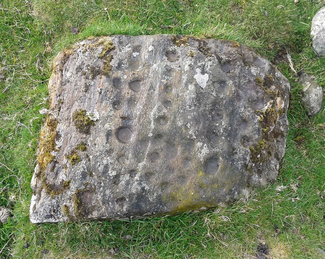
This is a fascinating and pretty impressive example of a simple cup-marked stone. It’s the design that does it I suppose – similar in some ways to the well-known Idol Stone carving on my old playground of Ilkley Moor (that’s what this one reminded me of when I first clapped eyes on it)—but much better!
Lines of cups from above
The carving from the east
Its similarity lies in the series of parallel rows of cup-marks running very close together along the line of the low-lying rock, found at the base of some ancient walling that runs up the mountain for several hundred yards. Not only that, but the line of walling itself also has a parallel line of walling running adjacent for the same distance up the mountainside — more than half-a-mile from start to finish. This “parallel” feature of walling and cup-markings is a curious coincidence, perhaps. But certainly the linearity of the cup-marks was itself a very deliberate feature by the person who carved it, representing something ‘structural’, in whatever mythic form that may have been!
The carving in its walling
Of the rows of cups constituting this petroglyph, four of them run completely from one side of the stone to the other, rough north to south; with four other shorter rows running only halfway across the rock surface. Altogether there are perhaps seventy cups etched onto the rock. No rings or semi-circles of any form were visible in our visit here—although the skies were grey and overcast, making any decent visual analysis more difficult.
A damn good carving and well worth checking out by anyone into prehistoric rock art!
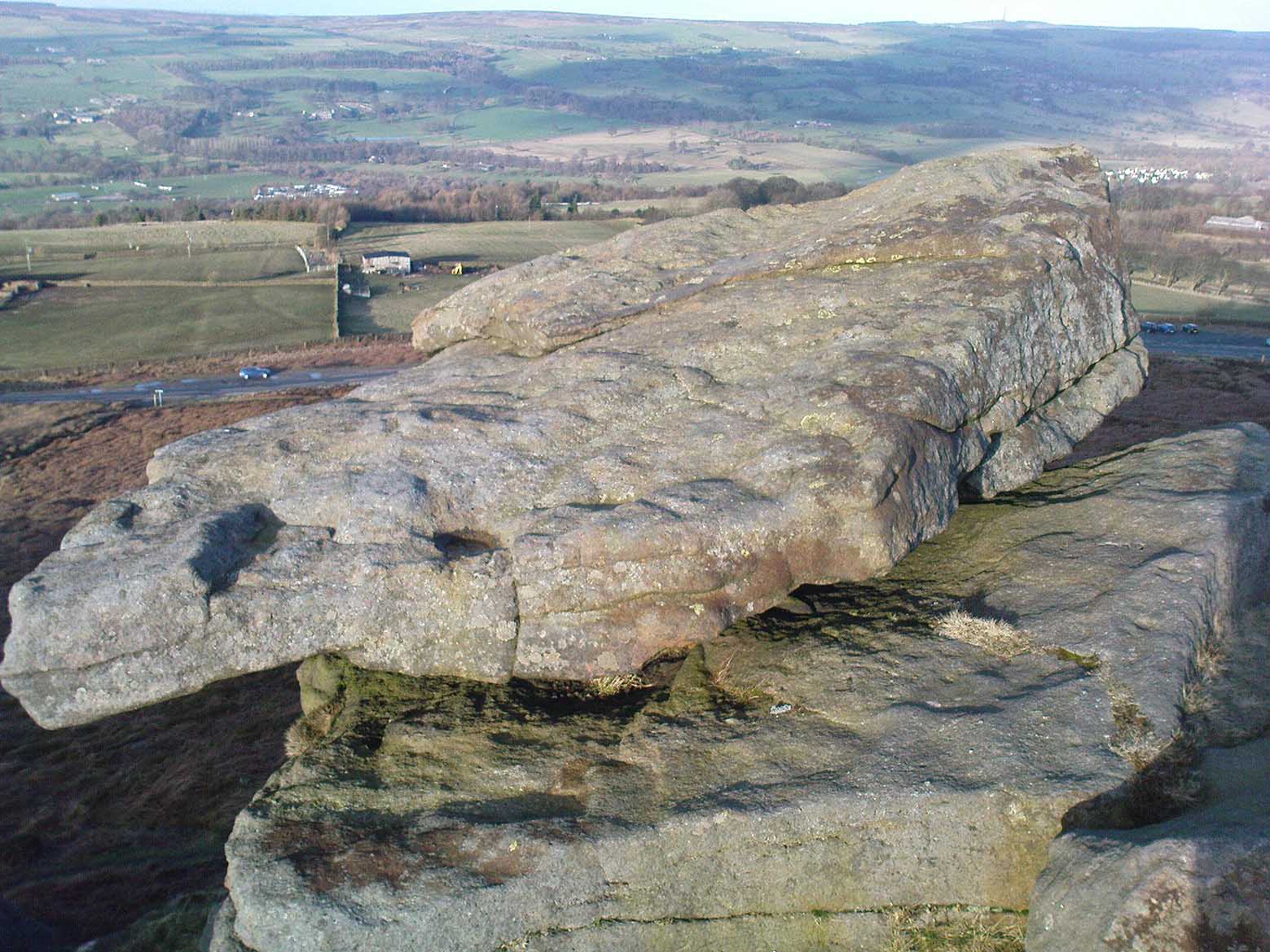
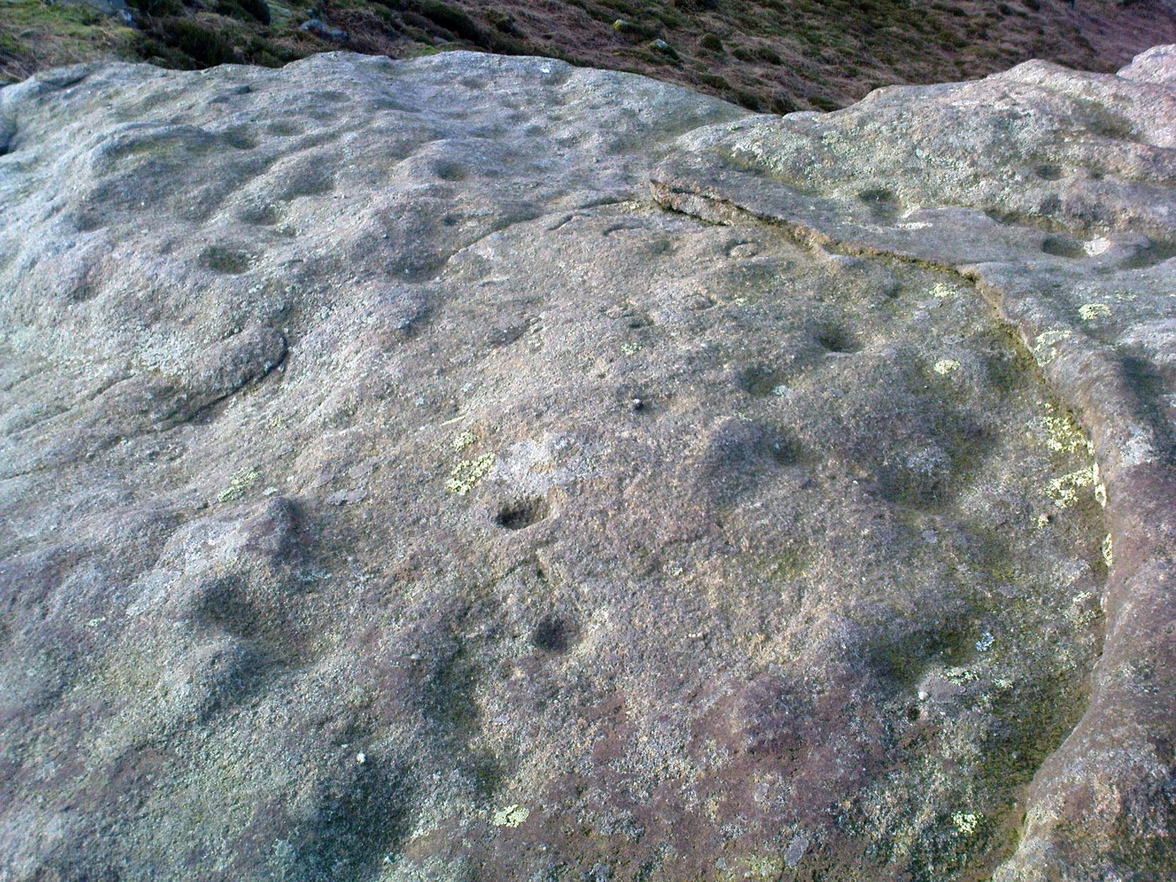
We were up here again the other week: wind, hail and snow blowing like hell, thankfully keeping the place to ourselves! To get here, head up Cow Pasture Road from the train station and up to the Cow & Calf Hotel near the famous rocks. Go past it a 100 yards or so and then look uphill onto the moors ahead of you. You’ll see a great over-hanging rock on the slope above you which looks as though its may fall down at any moment. That’s the Pancake Stone! Either walk up the steep path to get there quickly, or the longer route by taking the sloping diagonal path that runs eastwards until you’re on the same level.
Archaeology & History
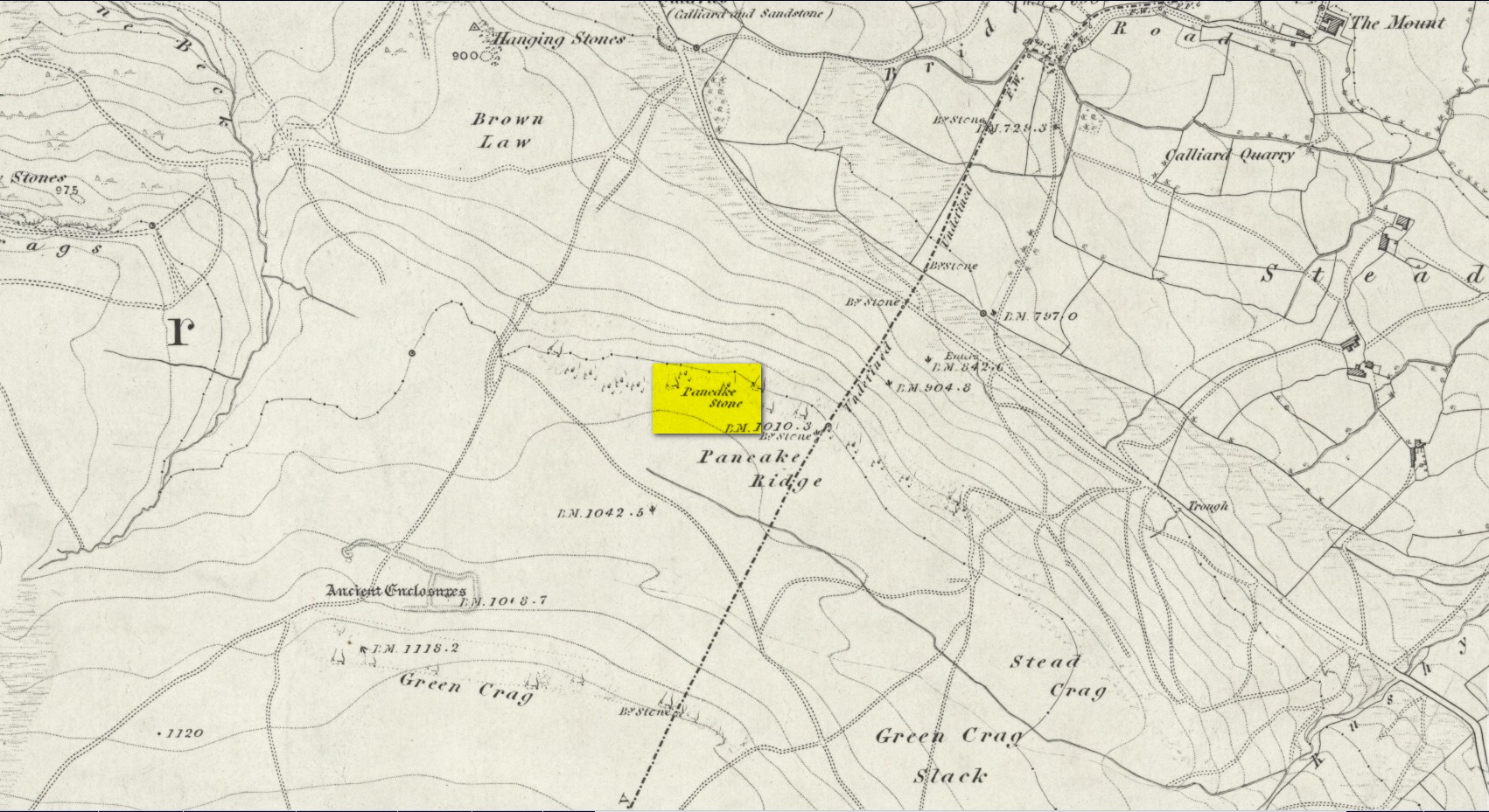
Site shown on 1851 map
Highlighted on the first Ordnance Survey map of the region in 1851, this prehistoric carved stone had been known as the Pancake Stone by local people long before any antiquarians gave it their literary attention to the place. It would have had tales told of it, no doubt, but they were never written down. It’s an impressive, some would say precarious piece of rock: an elongated thin wedge of stone resting gently on the cliff edge, much like a rocking stone to be honest, seemingly hanging onto the edge of the geological ridge awaiting its fall down the slope; but that’s not gonna happen for many more centuries yet.
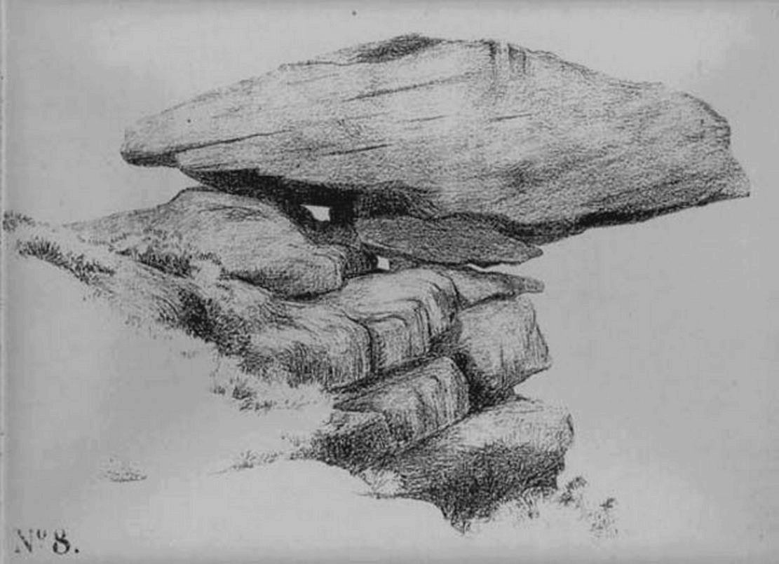
J. Thornton Dale’s 1879 drawingJ. Thornton Dale’s 1879 drawing
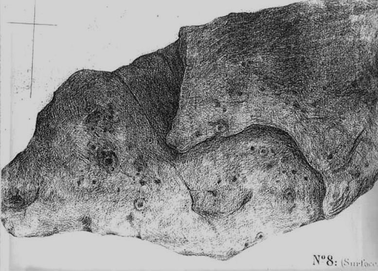
Much has been written about the petroglyph on the this wedge of stone, which covers much of its surface. Although a Mr J. Thornton Dale did a fine series of quite accurate drawings of this stone (and others on the moors) between 1878 and 1880, the first literary description of the Pancake rock carving appears to have been by the renowned J. Romilly Allen in 1882 (who evidently visited the stone on a cloudy or overcast day), saying that:
“On its upper surface are several cup-markings much obliterated by the actions of the weather, but some of them sufficiently distinct to prove their origin artificial, and to show that this rock was noticed in ancient times, and very possibly considered an object either of worship or superstition.”
Close-up of CnRsLooking across the stone
This latter assumption is highly probable. Strong animistic notions (moreso than usual) would be very evident here. Its position on the land with its outward focus from here towards other notable points in the landscape (Almscliffe Crags is one obvious focus); as well as looking at the rock itself from other viewpoints, give the stone considerable ritual importance. Sections of the moorland plain behind it—known as Green Crag—was the Land of the Dead in ancient times, and it is more than likely that death rites would have been enacted here — though we may never know what form they took.
Dale’s 1879 sketch
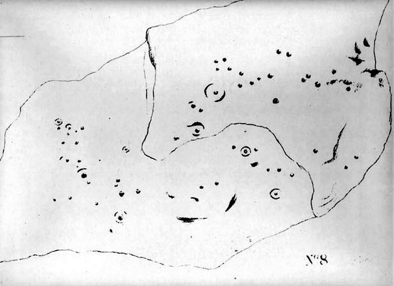
The stone has what seems to be at least 54 cup-markings on its upper face, with numerous grooves meandering and connecting other points. In J. Thornton Dale’s 1879 drawing of the upper surface, you will note that a couple of the rings he included have all-but faded away and are not included in the more recent surveys. Of the primary design, rock art students Boughey & Vickerman (2003) described there being “six complete and five partial rings” amidst the morass, but much of the design is very worn and, originally, there was probably a bit more to it all. The rock upon which the main Pancake Stone rests also has some worn cup-marks etched on its surface, a couple of which can be made out in the top photo.
Folklore
Good old Nicholas Size (1934) added this site to his list as a place where he had visions of the old christian cult, upon whose bare face were enacted blood rites and sacrifice. One Beltane Eve when he decided to amble up onto the moor edge, he could see a strange glow coming from behind the rock. He continues:
“Then suddenly I noticed there was a figure dancing upon it. The figure seemed to swirl round and round with floating draperies, grey or white, and I can only say that it looked very uncanny. Stupidly, I wondered that anybody could be such a fool as to dance in the darkness upon that precarious footing…”
But such activities on these moors, at certain times of the year, have been enacted for many centuries. It’s just kept quiet and, as more modern pagans (as they like to call ’emselves) keep coming up here and to other places, so the original folk move to their older and increasingly more secluded spots… In the latter half of the 20th century the site was used as a focus by chaos magickians, shortly after the inception of that Current.
References:
Allen, J. Romilly, ‘The Prehistoric Rock Sculptures of Ilkley,’ in Journal of the British Archaeological Association, volume 35, 1879.
Allen, J. Romilly, ‘Notice of Sculptured Rocks near Ilkley, with some Remarks on Rocking Stones,’ in Journal of the British Archaeological Association, volume 38, 1882.
Boughey, Keith & Vickerman, E.A., Prehistoric Rock Art of the West Riding, West Yorkshire Archaeology Service 2003.
Cowling, Eric T., Rombald’s Way, William Walker: Otley 1946.
Hedges, John, The Carved Rocks on Rombalds Moor, WYMCC: Wakefield 1986.
Jennings, Hargrave, Archaic Rock Inscriptions, A. Reader: London 1891.
Size, Nicholas, The Haunted Moor, William Walker: Otley 1934.
Speight, Harry, Upper Wharfedale, Elliott Stock: London 1900.