Old Pleck Barrow, Rushmore, Tollard Royal, Wiltshire

Tumulus (destroyed):  OS Grid Reference — ST 95459 17548

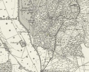
Old Pleck on 1889 OS-map

Archaeology & History

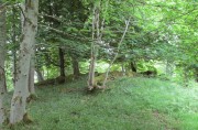
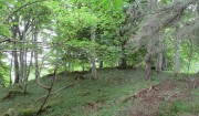
This long-lost burial mound was one in a large group of prehistoric tombs that were explored in the 19th century by the legendary antiquarian, General Pitt-Rivers. It had already been destroyed before the General came to live on his Rushmore estate in southern Wiltshire, but thankfully, his diligence as an inquirer prevailed and he was able to recover at least something of the old site.  Shown on the 1889 OS-map of the area (despite already having been destroyed), in Pitt-River’s (1888) extensive writings he told how, in the scattered woodlands hereby, was

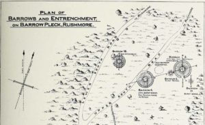
Pitt-Rivers 1888 site-map
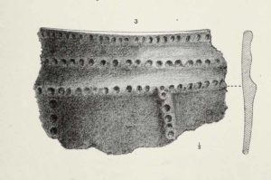
Old Pleck Barrow urn

a collection of large barrows near the South Lodge.  They were covered with a thick grove of hazel and other underwood.  One of the barrows—marked by a dotted circle (see sketch-map, left, PB)—had been destroyed before my arrival at Rushmore in 1880.  The earth of the barrow had been removed and a good urn found in it, which had been broken and scattered, but I was fortunate enough to recover one of the fragments which had been preserved by the estate carpenter.

From a sketch that was made of the urn remnant, Pitt-Rivers told how “the character of its ornamentation” resembled that on another urn found in one of the nearby tumuli.

References:

  1. Pitt-Rivers, A.H.L.F., Excavations in Cranborne Chase, near Rushmore – volume 2, Harrison & Sons: London 1888.

© Paul BennettThe Northern Antiquarian 


Montalt, Dunning, Perthshire

Cup-Marked Stone:  OS Grid Reference – NO 06 13

Also Known as:

  1. Canmore ID 26675
  2. Mount Alt Farm

Archaeology & History

Montalt’s curious cup-marked stone

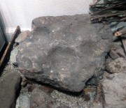
This is a curious stone and may not be the type of ‘cup-marked’ rock we’re used to.  Maybe… It is presently housed in Stirling’s Smith Art Gallery & Museum, where a small note tells that is was originally found “on the top of the Ochils, near Mount Alt Farm, Path of Condie in 1893.”  The stone was found at the same time, and adjacent to, a prehistoric collared urn—which implies it had an association with a cairn or cist, or burial site of some sort (which isn’t uncommon).  However, the exact location of its original whereabouts has been forgotten.

Broken off from a larger piece of stone, the remaining piece of rock has six cup-markings cut into it, between one and three inches across.  The smallest cup is what we might call a ‘normal’ size, but the rest of them get increasingly large and may have been more functional than purely mythic in nature.  In a small note attached to the stone in the Museum, they add the interesting note that,

“There are…indications that in some places they may be related to transhumance: the practice of moving sheep, cattle and goats to higher pastures in the summer, where they may have been used to mark routes or sources of water.”

They may indeed – amongst a variety of other things too.  But the suggested relationship with cattle occurs in stones found near Haworth, West Yorkshire, where large man-affected carved ‘cups’ such as the ones here, were known to be filled with milk at specific times of Nature’s calendrical rhythms, for the spirits of the place to give good fortune to the farmer and local people.  We know of one instance where this practice still occurs and goes back generations in the same family.  Examples of this animistic practice have also been found in the Scottish Highlands.

© Paul BennettThe Northern Antiquarian


Longbarrow Field, Timble, North Yorkshire

Cairn (lost):  OS Grid Reference — SE 18 53

Archaeology & History

Described in the Field Lore of Timble village by William Grainge (1895) are the names and short histories of some of the local place-names—with this in particular standing out like a veritable sore thumb!  Quite plainly, as Grainge told us,

“The name ‘Longbarrows’ is indicative of some burial mounds of a very early day.  None exist at present.  The land is under the plough, and is about the best in the township.”

But I cannot locate the position of this long-lost site and it’s not shown on any of the early OS-maps hereby.  Grainge said that the land on which it once stood was owned by a local farmer called Charles Dickinson, who leased it out to others.  He wrote:

“Dickinson had in Longbarrows 3 roods* and 23 perches*, and William Jackson’s share in Longbarrows was 1 acre, 3 roods and 21 perches.  Besides these, John Ward of Nether Timble had 1 rood and 17 perches int he same field, a long narrow slip without fence, between Dickinson’s and Jackson’s lots.”

Does anyone know where this was?  One of my suspects is the gathering place of the Fewston witches, a half-mile south of the village; but no remains of anything can be found there today and I may just be barking up the wrong tree.

The area south and west of here is rich in little-known prehistoric heritage, from the cairn-fields of Askwith Moor, the cairn circle at Snowden Crags, the settlements of Snowden Carr and the extensive petroglyphs all over the place!  Giants cairns of the early Bronze Age and neolithic period were also once more numerous upon the moors to the west and south, so the former existence of a long barrow in Timble wouldn’t necessarily be too unusual.  But where was it?!

References:

  1. Grainge, William, The History and Topography of the Townships of Little Timble, Great Timble and the Hamlet of Snowden, William Walker: Otley 1895.

*  A rood is an English unit of area, equal to a quarter of an acre or 10,890 square feet; a perch was a more variable unit of measure, being lengths of 1612, 18, 21, 24 and 25 square feet.

© Paul BennettThe Northern Antiquarian 


King’s Yett, St. Ninians, Stirlingshire

Cairn:  OS Grid Reference – NS 7373 8922

Also Known as:

  1. Canmore ID 45951

Getting Here

King's Yett cairn, from the track below

King’s Yett cairn, from the track below

Going west out of Stirling or St Ninians, you need to take the minor road/s that cross the M9 and head past the wooded hills, past Graystale and Wallstale.  A mile or so on, keep right when you hit the small road junction past Shielbrae.  A mile past here, where the edges of the road disappears into the moors and the forest grows to your right, park up where the small parking spot takes you down the track into the trees on the right-side.  Walk down here for a coupla hundred yards and keep yer eyes peeled for the rounded fairy-mound on the heaths about 30 yards above you.

Archaeology & History

When we visited this place a few weeks ago, the Dark was almost upon us when we arrived and the clouds were low with a deathly silent mist breathing from the trees and reaching up to meet the low clouds not far above.  It was a curious feeling, borne from the darkening landscape, feeling almost as if the dead were around us—which I suppose they were, in this prehistoric tomb at least.  At the clap of our hands, a great echo rang loudly from the misty silence and the land in which it lived.  Twas almost hypnotic in its lull…..

Looking to the NW

Looking to the NW

King's Yett cairn, looking NE

King’s Yett cairn, looking NE

This site isn’t always gonna have this feel to it of course.  If we’d have visited it on a nice clean blue-sky day, no such feelings would have greeted us—and the tomb would, perhaps, have been little more than an uninteresting-looking mound, overgrown with heather and grasses.  But Nature breathes and casts such entrancements to our central nervous system every now and then—and such states are as worthy of sincere attention as any intellect preys to insist otherwise…. and I should know!

The King’s Yett cairn has yet to be excavated, but it has all the hallmarks of a traditional Bronze Age signature in its structure.  When the Royal Commission  lads came here in 1954, after a report describing the mound, their brief account of it (1963:1) later told, simply:

“A cairn is situated on open moorland, a quarter of a mile W of King’s Yett, at an elevation of 950ft OD.  It consists of a grass-covered, stony mound which measures about 30ft in diameter and stands to a height of 4ft 6in.  A rectangular boulder which lies in the S arc of the base of the cairn, and which appears to be in situ, may have formed part of a peristalith.” (i.e., an encircling ring of stones, PB)

Adjacent circular mound nearby

Adjacent circular mound nearby

This singular fallen stone is now covered in vegetation and there is little evidence of any stone circle around the tomb.  But immediately west, 70 yards WNW on the other side of the forestry track, rises an even larger circular mound, deeply covered in heather and consisting of earth and stones beneath the surface.  It looks for all the world like another giant cairn (up to 6ft high and measuring about 26 yards (23.9m) E-W, by 27.5 yards (25.2m) N-S) upon which new trees have recently been planted.  It might not be, of course—but we’re gonna look at this again when She gives us more daylight and clearer skies…..just in case…

Locally there are various tales of the Sma’ Folk or little people, fallaciously ascribed by romantic intellectuals as ethereal spirits, but which were and are known to have been tribal people in these uplands; and although such stories excel in this area, we have nothing specific relating to the rounded mound of King’s Yett – yet!

References:

  1. Royal Commission on the Ancient & Historical Monuments Scotland, Stirling – volume 1, HMSO: Edinburgh 1963.
  2. Royal Commission on the Ancient & Historical Monuments of Scotland, Archaeological Sites and Monuments of Stirling District, Central Region, Society of Antiquaries of Scotland 1979.

© Paul BennettThe Northern Antiquarian


Garadh Ban Wood, Buchanan, Stirlingshire

Chambered Cairn:  OS Grid Reference – NS 45217 91907

Also Known as:

  1. Canmore ID 282019

Getting Here

The main stones in this ruined cairn

The main stones in this ruined cairn

On the B837 between Balmaha and Drymen at the hamlet called Milton of Buchanan, at the little road junction where the houses are on the right, go uphill for 1 mile (1.6km) until you reach the West Highland Way, where you need to go left (NW).  Keep walking for another half-mile (if you get to end of the forestry plantation, you’ve gone too far) where, on your left, a small widening valley appears.  Walk along the eastern edge of this, keeping your eyes peeled for a small upright stone and two large flat companions next to it.

Archaeology & History

This site is really only for the archaeological purists amongst you, as the forestry plantation has truly taken its toll on the site and very little of it remains.  It appears to have been described first of all in H.G. Smith’s (1896) masterful local history work—although popular tradition was not assigning the place as a prehistoric tomb of any sort.  Rather, it possessed a somewhat familiar folklore element, well-known to occult historians and antiquarians.  Smith told us:

“Not far off, in Garradh-ban Wood, is the ‘Deil’s foot mark stone‘.  It is a large flat stone, 7 feet long and 6 feet wide, with an impression on it not unlike a huge foot mark.  There is another stone close to it, 7 feet by 5 feet.  These stones were probably placed there for some purpose now unknown.”

Mr Smith’s dimensions of the stones correlate closely with the modern analysis taken up by the archaeologists who visited the site more than 100 years later.  Mainly comprising of two large stones on the ground with an accompanying upright monolith on the western side, the official Canmore account tells us:

“The cairn has been reduced to a low stony mound measuring 15m from N to S by 12m transversely and up to 0.5m in height. The chamber, which lies off-centre to the SW, comprises two upright stones and two displaced capstones. The overall plan of the chamber can no longer be determined, and the two upright stones are set splayed to one another; that on the W measures 0.53m by 0.25m and 0.15m in height, and that on the E is heavily laminated measuring 1m by 0.18m and 0.8m in height. The SE corner of one capstone rests on the smaller of the two uprights. It measures 2.1m by 2.03m and up to 0.3m in thickness, and has two fragments broken off at its NE corner. The second capstone lies immediately adjacent to the N, flush with the surface of the cairn, and measures 2.3m by 1.7m and 0.17m in thickness.”

When they assessed the site in 2006, archaeologists reported finding small pieces of quartz scattered over the surface of the cairn, but when we visited here last week, there was little trace of any.

The 'Deil's foot mark'

The ‘Deil’s foot mark’

Garadh Ban, looking west

Garadh Ban, looking west

I was hoping that the “Devil’s footmark” on the stone was going to be a cup-marking of some form, as found at some other sites (Kilneuair church, etc)—but it wasn’t to be.  Instead, it seems that the curvaceous indentation left by the ‘devil’ was simply a natural cavity.  The folktale behind the name, and its possible cultural function, seems to have been forgotten.

Although (perhaps) unrelated, H.G. Smith told us of other remains not too far from here, which remain elusive and not in any official record-books.  We had a quick meander over to see if there was anything to be seen, but daylight was fading fast and more searches are required.  It sounds intriguing:

“A little above these ruins (of Cul-an-Endainn farmhouse at NS 4453 9244 – PB), on the right of the burn, but considerably above it, is a curious structure built of turf.  It is quite round, and is 25 feet in diameter at the top and 15 feet at the bottom.  It has entrances at the south, east and west.  There are others of the same construction both above and below, but not so well defined.”

Recently, industrialists have gone onto this part of the countryside and have already began scarring the hillsides, perhaps even destroying these curious remains before we’ve had a chance to assess them.  Hopefully however, they will remain untouched and allow us site analysis before any real damage is done.

Folklore

Followers of the christian cult said this site was a place where the devil had been.

References:

  1. Smith, H. Guthrie, Strathendrick and its Inhabitants from Early Times, James Maclehose: Glasgow 1896.

Acknowledgements:  Many thanks to Aisha Domleo, Lara & Leo Domleo, Unabel Gordon, Nina Harris, Paul Hornby and Naomi Ross for their help and attendance in finding this ancient site. 

© Paul BennettThe Northern Antiquarian


Gray Stone, Dunning, Perthshire

Standing Stone:  OS Grid Reference – NO 02182 11809

Also Known as:

  1. Big Stane
  2. Canmore ID 26681
  3. Grey Stone
  4. Maormar‘s Stone

Getting Here

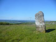
Grey Stone, looking NE

Take the B934 road south, uphill, out of Dunning, for 2.1 miles (3.4km), past Kippen, past Pitmeadow and past Quilts.  It’s the track to Knowes that you’re after!  Along this track, keep to the field-side on your right, following the edge of the fencing until you reach the small copse of trees.  At the far side of the trees a gate takes you into the field with the standing stone, which is just over 100 yards to the north. You can’t miss it!

Archaeology & History

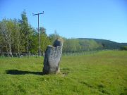
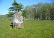
Although mentioned in several folklore works and just a couple of archaeology tomes, almost nothing has been written about this large upright standing stone.  A very bulky stone nearly seven feet tall, it has been broken into pieces at sometime in the recent past but, thankfully, good locals put the stone back together and placed it upright once again.  Its position in the landscape is quite superb, overlooking the lowlands of Tayside below and then far into the rising mountains of Perthshire and beyond, easy fifty miles or more.


Grey Stone, looking south
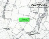
Gray Stone on 1866 map

Shown on the earliest Ordnance Survey map of the area, the name of the stone is somewhat of a puzzle, for in a lot of cases ‘gray’ stones are found on local boundary lines—indeed, the name gray stone and boundary stone are interchangeable in many cases—yet the nearest boundary from here is some distance to the east.  It may simply relate to the colour of the rock (although this is unlikely).  Whatever its reason, it’s an impressive stone and is well worth checking out!

Folklore

Gray Stone, looking east

The local farmer told that the field where the Grey Stone lives was known as the Big Stane Field.  Makes sense!  Legend has it that the Gray Stone was the burial place of Maormor, the Steward of Atholl in the Battle of Duncrub, after dying in Thanes Field (Watson 1995), on land to the north of Dunning village in 964-5 CE.

References:

  1. Holder, Geoff, The Guide to Mysterious Perthshire, History Press 2006.
  2. McKerracher, Archie, Perthshire in History and Legend, John Donald: Edinburgh 1988.
  3. Swarbrick, Olaf, A Gazetteer of Prehistoric Standing Stones in Great Britain, BAR: Oxford 2012.
  4. Watson, Angus, The Ochils: Placenames, History, Tradition, PKDC: Perth 1995.

© Paul BennettThe Northern Antiquarian


Orwell, Milnathort, Kinross

Standing Stones:  OS Grid Reference – NO 1494 0432

Also Known as:

  1. Canmore ID 27912
  2. Mawcloych

Getting Here

The Orwell standing stones

The Orwell standing stones

Drive from Milnathort SE down the A911 road towards Balgedie and Scotlandwell.  About a mile out of the village, keep your eyes peeled on the farmed fields on your left.  You’ll notice the standing stones a few hundred yards ahead and, if you, see them in time, will be able to park up by the track on your left a coupla hundred yards before Orwell Farm. Ensure you visit this site between October and March – otherwise the fields are in full crop.

Archaeology & History

Stones marked on the 1857 map

Stones marked on the 1857 map

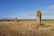
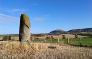
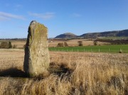
These are impressive standing stones by anybody’s standards.  Although we have two impressive uprights today on the highest point in the potato fields, in the 19th century the place-name writer Liddall (1896) told that “in this district are still three large pillar stones known as the Standing Stones of Orwell.” (my italics)  Their existence was recorded, he said, in early topographical accounts in an obsolete place-name Mawcloych, or “place of the stones.”  But if there were three standing stones here, they must have stood prior to the article written by the pseudonymous “W.H.”, who described them in the October edition of The Scottish Journal in 1847, saying:

“About half-a-mile above the old (Orwell) churchyard, in a field by the roadside, are two large upright stones, known as “the Standing Stones of Orwell.”  They are placed east and west of each other about fifteen yards apart—that to the west is flat, and about six feet in height—the one to the east is of a round form, tapering slightly to the ground, and stands nine feet high.  The latter, although still of considerable size, has lost somewhat of its circumference within the last ten years, and, at the present moment, there is a large crack down one side, which, by the action of the weather, will lead to a further diminution of its bulk. It has not been ascertained to what depth these stones are embedded in the earth, but it must be considerable, in order to retain them in the position they occupy.

“The common belief is, that these stones are of Danish origin, erected in commemoration of a victory, or to mark the spot where those who had fallen in battle were interred. This supposition is so far countenanced by the fact that a stone coffin, of large size, was found on digging up the space between the stones. Similar coffins have also been turned up in the same field, and, ten or twelve years ago, the ground was dug up in several places by a neighbouring proprietor, when large quantities of bones, much decomposed and mixed with charcoal, were discovered.”

Fred Coles 1906 ground-plan
Fred Coles 1906 ground-plan

Orwell Stones, looking north

Orwell Stones, looking north

This early description telling of the poor condition of one of the stones presaged its eventual fall in the late 1960s; but this thankfully led to an archaeological evaluation which gave us more information about the site.  Before this however, the great northern antiquarian Fred Coles (1906) visited the stones in August 1904, describing them with his usual meritorious detail, telling:

“They stand on a very gently rising ground, the space between them and for some distance to the south being somewhat higher than the surrounding field.  In ground plan they are related as shown (attached).  The east stone is the higher, standing 9 feet 8 inches clear of theground, smooth-sided and hexagonal. At the base its girth is 9 feet 9 inches, swelling up at the 5-foot level into 10 feet 8 inches. The West Stone, very rugged and angular, is 7 feet 5 inches in height, girths at the base 11 feet 1 inch, and at about 3 feet upwards, 10 feet 5 inches, its broadest side facing the East Stone. Both are of whinstone. The shortest distance between the two Stones is in a line nearly north-west, and measures 46 feet 10 inches.

“Mr R. Kilgour, one of the oldest residents of Kinross, showed me a fine partially flattened oval pebble of dark reddish quartzite, measuring 5 inches by 2⅞ inches, which he found in the ground between these two Stones. The abrasion at each end clearly shows that this pebble has been used as a pounder.

“In a book which to some extent deals with local antiquities, occurs the following passage with reference to these two Standing Stones: ‘In the same field stone coffins have occasionally been turned up by the plough; and, about the beginning of the 19th century, the ground was in many places dug up by the neighbouring proprietor, when quantities of bones much decomposed and mixed with charcoal were discovered.’”

But after the west stone fell down, J.N.G. Ritchie (1972) and his team turned up to resurrect it—and also check out what might be underneath it.  His initial notes of the findings were published in Discovery & Excavation Scotland, which said:

“Excavation at the bases of these two standing stones…was undertaken prior to the re-erection of the W stone and to the embedding of both stones in cement.  The original position of the fallen stone could be detected only as a slight hollow in the natural gravel, but as this corresponded with the position of the stone on Coles’ plan…the stone could be re-positioned comparatively accurately.

“A cremation deposit was found in an insubstantial stone setting in a scoop in the natural gravel some 0.5m S of the stone.  The E stone, which is an impressive whinstone 3.8m in total height, had been set up in a hole 1.5m x 1.4m and 0.75m in depth.  Within the pit on the SW side of the stone there was an unusual two-storeyed cremation deposit; the lower cremation was contained within a rough setting of stones with one side formed by the standing stone itself, and was covered by a flat slab.  On this slab and again surrounded by a setting of small stones was the upper cremation.  It seems most likely that these were inserted into the stone hole at the time of the erection of the stone. Another cremation was found at the lip of the stone hole on the SE side.  The discovery of cists and cremation patches in the same field in the early 19th century suggests that the stones have acted as a focus for such burials.”
The southeasterly stone
The southeasterly stone

The northwesterly stone

The northwesterly stone

Ritchie (1982) later wrote how they had found “burnt dog and pig bones with the lower cremation deposit,” implying “rituals” at the site.  He even posited how such deposits at standing stones “may have a bearing on their postulated use  as astonomical markers,” although Alexander Thom’s (1990) exploration of the Orwell stones indicated no archaeoastronomy here.  So it seems very obvious that these giant monoliths were markers for a neolithic and/or Bronze Age cemetery or necropolis in prehistoric times.  Aubrey Burl (1993) defined the stones here as having “an Irish setting, with the east emphasized, as alway, by the taller stone.”

Fred Coles' 1906 drawing

Fred Coles’ 1906 drawing

Unmentioned by the archaeologists in all of the references I have at hand, is the probable relationship the Orwell stones had with the rising background of the Lomond Hills to the east, with its archaic legends of cailleach, neolithic tomb creations and other geomantic indicators.  These elements (and more) need to be explored more diligently by forthcoming students.  It’s a remarkable setting as far as I’m concerned!

References:

  1. Burl, Aubrey, “Pi in the Sky”, in Douglas C. Heggie’s Archaeoastronomy in the Old World, Cambridge University Press 1982.
  2. Burl, Aubrey, From Carnac to Callanish, Yale University Press 1993.
  3. Coles, Fred, “Notices of Standing Stones, Cists and Hitherto Unrecorded Cup-and-Ring Marks in Various Localities,” in Proceedings of the Society of Antiquaries, Scotland, volume 40, Edinburgh 1906.
  4. Day, J.P., Clackmannan and Kinross, Cambridge University Press 1915.
  5. Feacham, Richard, Guide to Prehistoric Scotland, Batsford: London 1977.
  6. Jack, James W., Glenfarg and District – Past and Present, Miller & Smail: Perth 1903.
  7. Liddall, W.J.N., The Place Names of Fife and Kinross, William Green: Edinburgh 1896.
  8. Ritchie, J.N.G.,”Orwell Standing Stones,” in Discovery & Excavation in Scotland, 1972.
  9. Ritchie, J.N.G., “Archaeology and Astronomy: An Archaeological View”, in Douglas C. Heggie’s Archaeoastronomy in the Old World, Cambridge University Press 1982.
  10. Royal Commission on the Ancient & Historical Monuments of Scotland, Fife, Kinross and Clackmannan, HMSO: Edinburgh 1933.
  11. Simpkins, John Ewart, County Folklore – volume VII: Examples of Printed Folk-Lore Concerning Fife, with some Notes on Clackmannan and Kinross-Shires, Folk-Lore Society: London 1914.
  12. Thom, A., Thom, A.S. & Burl, Aubrey, Stone Rows and Standing Stones – volume 2, BAR: Oxford 1990.
  13. “W.H.”, “A Ramble in Kinross-shire,” in The Scottish Journal of Topography, Antiquities, Traditions, volume 1, 1848.

© Paul BennettThe Northern Antiquarian
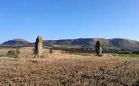

Tongue House, Tongue, Sutherland

Chambered Cairn:  OS Grid Reference – NC 5926 5862

Also Known as:

  1. Canmore ID 5325

Getting Here

Tongue House chambered cairn amidst the trees

I approached this by walking along the B8438 road northwest out of Tongue village, towards the road-crossing over the Kyle of Tongue.  There’s a small tiny road on the right (easily missed) nearly a mile out, just as the road starts to bend, which leads you down to Tongue House.  Go along here for about 325 yards (300m) and just as the road bends to the left, walk into the woods. Keep straight forward, following the low-level stream, and when you see the buildings ahead of you, veer diagonally upslope until you hit the large Tongue Burn. Cross this and walk uphill to the tree-covered knoll ahead. You’re there!

Archaeology & History

…and again, looking north

From the descriptions I’d read of this site, I wasn’t expecting much at all—but it was much better than I anticipated, and in a beautiful woodland setting too.  Admittedly the site is much overgrown, but the overall size, edges and outline of the tomb is easily discernible.  In pacing across it, from outer-edge to outer-edge, it measured 18 yards by 19 yards across.  All round the edges are many overgrown tumbles of smaller rocks which obviously had been part of the cairn in previous centuries; but it is primarily defined by the larger earthfast rocks at the very top of the natural knoll in the trees, all of them covered in deep mosses.

The site was first mentioned in James Horsburgh’s (1870) survey of the region.  He explored a small section of the monument and, upon digging, found a chamber therein—defined by Audrey Henshall (1963) as “a single compartment chamber”—telling us:

“A little to the south of Tongue House, and near the fountain head that supplies it with water, there is the chamber of a cairn of the same description as that near Skelpick, but rather smaller; on clearing it out, I found that one of the large upright stones had two holes bored artificially a short way into each of its sides, but not quite opposite, the holes were about 3 inches diameter.”

However, these internal structures have not been seen since and in Henshall & Ritchie’s (1995) catalogue of Sutherland’s giant tombs, there is some confusion over the definition of the structure itself, questioning whether or not it was indeed a chambered tomb.

“The ‘chambered cairn’ is a circular stone structure overgrown with small trees and covered in leaf-litter and moss.  A kerb about 15m in diameter can be traced for much of the circuit.  The kerb is of unusually substantial and closely-set boulders which have the appearance of the base of a massive wall such as is inappropriate for a dun or a broch rather than a cairn.  The interior is filled with loose stones including some quite large boulders, roughly to the level of the top of the kerb.  There is no indication that these boulders have formed part of a neolithic chamber or that the structure was a cairn.  There seem to be three possibilities: that the structure is not Horsburgh’s cairn; that the structure is that which he investigated but that he was mistaken in regarding it as a chambered cairn; that the writers are mistaken in identifying the structure as a ruined broch or dun.”

Despite this, the general consensus today is that the monument is indeed a chambered cairn.

References:

  1. Henshall, Audrey S., The Chambered Tombs of Scotland – 2 volumes, Edinburgh University Press 1963 & 1972.
  2. Henshall, Audrey S. & Ritchie, J.N.G, The Chambered Cairns of Sutherland, Edinburgh University Press 1995.
  3. Horsburgh, James, Notes of Cromlechs, Duns, Hut-circles, Chambered Cairns and other Remains, in the County of Sutherland“, in Proceedings Society of Antiquaries, Scotland, volume 7, 1870
  4. Royal Commission on Ancient & Historical Monuments, Scotland, Second report and inventory of monuments and constructions in the county of Sutherland. HMSO: Edinburgh 1911.

© Paul BennettThe Northern Antiquarian


Tillicoultry House Carving, Tillicoultry, Clackmannanshire

Cup-and-Ring Stone (lost):  OS Grid Reference – NS 9240 9752

Also Known as:

  1. Canmore ID 48255

Archaeology & History

Multiple-ringed carving, Tillicoultry

Multiple-ringed carving, Tillicoultry

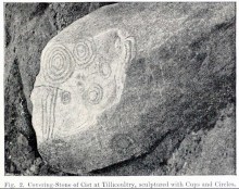
A recent visit to try find this intricate carving—the only one of its kind in Clackmannanshire—proved unsuccessful, and so I add it here in the hope that someone might know where it is and bring it back to light.  It looked like quite an impressive petroglyph.  If the stone isn’t hiding in undergrowth at the edge of someone’s garden, it may well have been destroyed—which would be appalling.  As a unique design, this important carving should have been preserved.  Even when the Victorian explorers found it, the covering stone circle had been greatly damaged and many stones in the ring had been removed.  This carved stone remained intact however.  When Mr R. Robertson (1895) and his friend visited the site, it was covered in sand and dirt and had fallen to the side of an internal cist:

“On clearing this away a remarkable feature was brought to light.  The block was found to be elaborately ornamented on its sides and upper surface, with rings, spirals and lines.  The labour of cutting these in the hard granite with primitive tools of the period must have been very great. Several successful photos of the stone and its carvings were taken by Provost Westwood, Dollar…. This stone has now been removed to the vicinity of Tillicoultry for safety.”

In the same article, George Black told slightly more of the design:

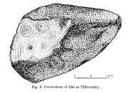
“The covering stone of the cist…bears on the face a series of concentric circles, and spirals springing from one of the groups of circles,  Four grooves also unite the same set of circles with the left-hand edge of the stone.  On the edge shown in the photograph there is another group, consisting of two concentric circles.  The unevenness of the surface of the stone appears to have been of no moment to the sculptor of the circles, as the incisions follow the surface into its sinuosities and depressions.”

Not long after Robertson & Black’s visit, the great megalithomaniac Fred Coles (1899) came here—and he found that the “spirals” that Mr Black described were nothing of the sort.

“The huge irregularly-shaped diorite boulder which covered the cist has several cup-and-ring marks on one face and one side…. These marks are now, so I was informed when inspecting them, very much less distinct than they were when the photograph was taken (above) in 1894.  It would be difficult now to describe the incised markings with accuracy; it is difficult even to see them when wet.  But…I must take exception to the term ‘spirals’ as applied to any of these ‘rings.’  There are three groups of rings so placed as to make the outermost ring in each group touch that of the others (not an uncommon form), but there is no one true volute.

“…What is more noteworthy is the group of four long parallel, nearly perpendicular grooves issuing (probably) from the outermost ring of the group of five rings, and ending at the edge of the boulder.”

Alison Young's 1937 sketch

Alison Young’s 1937 sketch

Cole also noted that the carvings were to be found on the upper surface of the stone.  It would seem very probable that the excessive erosion which Cole described was due to the fact that the stone was, many centuries earlier, exposed to the elements within the stone circle and not buried as it later came to be.  It makes sense.

The excessive erosion was spoken of by the Royal Commission (1933) lads, aswell as the last person to describe the site, Ronald W.B. Morris (1981), who said that during his visits here between 1966-75,

“the author has only found traces of possible cups visible on the rough surface, which has flaked badly.”

Morris (1981) said that the stone measured “1½m by 1¾m by ½m (5½ft x 4½ft x 2ft)”—and was last known to be some 10 yards NW of the Tillicoultry House cottage, but we could locate no trace of the stone or its carving.  If anyone is aware of the whereabouts or fate of this important neolithic carving, please let us know.

References:

  1. Coles, Fred R., (1899b) ‘Notices of the discovery of a cist and urns at Juniper Green, and of a cist at the Cunninghar, Tillicoultry, and of some undescribed cup- marked stones’in Proceedings of the Society Antiquaries, Scotland, volume 33, 1899.
  2. MacWhite, Eoin, “A New View on Irish Bronze Age Rock-Scribings,” in Journal Royal Society Antiquaries, Ireland, 76:2, 1946.
  3. Morris, Ronald W.B., ‘The cup-and-ring marks and similar sculptures of Scotland: a survey of the southern Counties, part II’in Proceedings of the Society Antiquaries, Scotland, volume 100, 1969.
  4. Morris, Ronald W.B., “The Cup-and-Ring and Similar Early Sculptures of Scotland; Part 2 – The Rest of Scotland except Kintyre,” in Transactions of the Ancient Monuments Society, volume 16, 1969.
  5. Morris, Ronald W.B., The Prehistoric Rock Art of Southern Scotland, BAR: Oxford 1981.
  6. Robertson, R., Black, G.F. & Struthers, J., ‘Notice of the discovery of a stone cist and urns at the Cuninghar, Tillicoultryin Proceedings of the Society Antiquaries, Scotland, volume 29, 1895.
  7. Royal Commission on the Ancient & Historical Monuments of Scotland, Fife, Kinross and Clackmannan, HMSO: Edinburgh 1933.
  8. Young, Alison, “Cup-and-Ring Markings on Craig Ruenshin, with some Comparative Notes,” in Proceedings of the Society Antiquaries, Scotland, volume 72, 1937.

© Paul BennettThe Northern Antiquarian


Dumpton Park, Ramsgate, Kent

Tumulus (destroyed):  OS Grid Reference – TR 389 661

Archaeology & History

A little-known site which archaeologist Brian Philp (2002) called “a Bronze Age barrow”.  When the old Greyhound Stadium at Ramsgate was being demolished for a new housing estate, planning conditions required an archaeological evaluation and so Philps and his team set out to explore the area in February 2000.  They weren’t to be disappointed!  Unearthing a ring ditch nearly 20 yards (18m) across, they found that it had been cut into the local chalk some three feet deep.  Although there was no obvious entrance, the northeast section of the ancient monument,

“was found to be covered by a compact layer of flint metalling.  This was a wide and well-made surface or platform, perhaps of Iron Age date, which clearly covered the silted ring-ditch,  Nearby was a large male skeleton in a very shallow grave and with head missing due to later disturbances.”

The excavated ring ditch (after Philp 2002)

The excavated ring ditch (after Philp 2002)

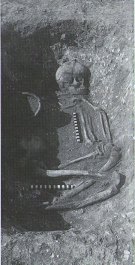
The crouched skeleton (after Philp 2002)

The crouched skeleton (after Philp 2002)

But the best was yet to come!  In another section of the circular monument, cut into the chalk itself, they found a complete male skeleton laid in typical foetus position, on its left side, with a large beaker pot positioned in front of it.  These beakers are pretty common and tend to be seen as once holding food enabling the dead to eat in their journey into the Land of the Dead.  It makes sense.  The entire monument has since been completely destroyed.

References:

  1. Philp, Brian, Archaeology in the Front Line, KARU: Dover 2002.

Links:

  1. Kent Archaeological Review

© Paul BennettThe Northern Antiquarian 2016