Gleneagles ‘A’, Blackford, Perthshire

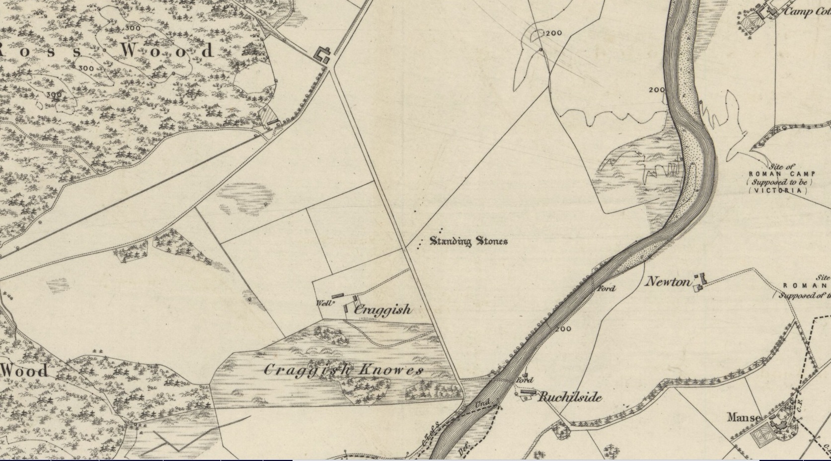
Standing Stone:  OS Grid Reference – NN 9211 0962

Also Known as:

  1. Blackford
  2. Loaninghead
  3. Peterhead Farm

Getting Here

Monolith nr Peterhead Fm

Along the A9 dual carriageway between Blackford and Auchterarder, take the A823 road south, up the Glen Eagles road as if you’re heading towards Pool of Muckhart and Dunfermline.  Less than 100 yards up the road, turn immediately right and go past the standing stone of Gleneagles B for a coupla hundred yards or so, where there’s a left turn (down to Peterhead Farm).  Stop here and look into the field in front of you.  You can’t really miss it!

Archaeology & History

Gleneagles ‘A’, gazing west

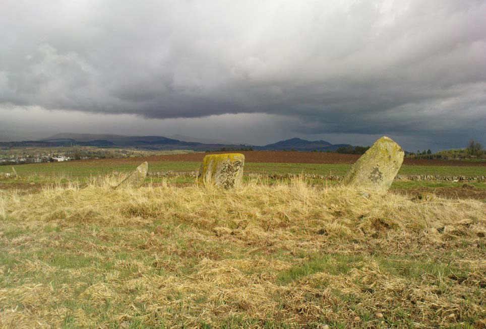
This short standing stone, more than 3ft tall, has an elegance about it which megalith lovers alone will understand!  Maybe it’s the setting; maybe the feel of the land; or maybe something else.  I dunno… On my first visit to the site, Nature was wearing a grey overcast cloak, but the site and I didn’t seem to care; and although the view from here doesn’t have the same grandeur of Glen Eagles to view as its companion stone a few hundred yards to the east might have, there felt a greater welcoming at this smaller stone.  Odd, considering this monolith had been knocked over and re-positioned by the farmer in the not-too-distant past.  Anyway…less of this subjective nonsense of feelings from the landscape and megaliths!  Utter drivel all of it!

The earliest measured account of the stone is to be found in Mr Hutchison’s (1893) essay, where he notes this and its companion close by, giving us the dimensions of this monolith:

“This (stone) is roughly columnar in shape, but wider at the base than above. Its height is 3ft above ground; circumference at base 6ft. 5in., diminishing to 4ft. 2in at the top. It is of metamorphic schist.  The line of direction between these two gives a horizontal angle of 260°.”

Since that day, in the mass of archaeology essays that have been scribed, this smoothed upright gets only a minimal description.  Charles Calder’s (1947) account is typical, saying simply that it is,

“Somewhat cylindrical in form with a girth of 7 feet at the base, it rises with a decided tilt towards the west to a height of 3 feet 10 inches above ground-level.”

The stone fares better in Andrew Finlayson’s (2010) fine local survey of megalithic ruins, where he points out that this and its compatriot stone Gleneagles B, are in an alignment with the fallen Boat Stone and the upright White Stone, a few miles to the southwest.  This line works on 1:50,000 map, but when transferred to larger-scale surveys, the alignment misses each outlying site by 20-30 yards here and there.

References:

  1. Calder, Charles S.T., “Notice of Two Standing Stones (one with Pictish Symbols) on the Lands of Peterhead Farm, near Gleneagles, Perthshire,” in Proceedings of the Society of Antiquaries, Scotland, volume 81, 1947.
  2. Feachem, Richard, Guide to Prehistoric Scotland, Batsford 1977.
  3. Finlayson, Andrew, The Stones of Strathearn, One Tree Island: Comrie 2010.
  4. Hutchison, A.F., “The Standing Stones of Stirling District,” in The Stirling Antiquary, volume 1, 1893.

© Paul Bennett, The Northern Antiquarian


Craggish, Comrie, Perthshire

Standing Stones (destroyed):  OS Grid Reference – NN 7643 2086

Archaeology & History

Site shown on 1886 OS-map

Highlighted on the 1866 OS-map was an impressive cluster of standing stones that sadly met their demise sometime around at the end of the 19th century.  They were mentioned to “still exist” when the local writer Samuel Carment passed them in 1882, but had been destroyed by the time the Ordnance Survey lads resurveyed here in 1899.  Altogether there were at least six of them, standing aligned sharply northeast-southwest and were described in one of Fred Coles’ (1911) essays, who lamented their passing.  Listed in the stone row surveys by Burl (1993) and Thom (1990), the prime description we have of them was by Cole himself, who told:

“This site has also been wantonly bereft of its group of megaliths.  Up to so recent a date as 1891 there were several.  These were shown on the (Ordnance Survey map) as three in one line and two in another, on a field about one furlong NE of Craggish farmhouse, close to the road coming down from Ross, and nearly a quarter-mile NW of the ford across the Ruchil at Ruchilside.”

In Finlayson’s (2010) colourful survey of the local megaliths he told that the stones,

“Stood, by the road, in what is now ‘The Whinney Strip’: a boulder-strewn strip of land 20m wide dividing up otherwise flat and even grazing land.”

References:

  1. Burl, Aubrey, From Carnac to Callanish, Yale University Press 1993.
  2. Cole, Fred, “Report on Stone Circles Surveyed in Perthshire, Principally Strathearn,” in Proceedings of the Society of Antiquaries, Scotland, volume 45, 1911.
  3. Finlayson, Andrew, The Stones of Strathearn, One Tree Island: Comrie 2010.
  4. Thom, A., Thom, A.S. & Burl, Aubrey, Stone Rows and Standing Stones – 2 volumes, BAR: Oxford 1990.

Acknowledgments:  Big thanks for use of the early edition OS-map in this site profile, Reproduced with the kind permission of the National Library of Scotland

© Paul Bennett, The Northern Antiquarian


Carleith, Crook of Devon, Kinross-shire

Cairn:  OS Grid Reference – NT 0404 9877

Getting Here

Carleith Cairn, from roadside

Go along the A977 road out of Powmill village towards Crook of Devon, and as the road swerves uphill, past the Powmill Milk Bar on the right-hand side of the road, take your next right.  Go along this small country lane for a mile or so, past Maidenwells Farm; then as you go uphill, stop at the very top.  Look in the field on your left, where a small round clump of trees are surrounded by circular walling.  The cairn’s inside the protective walling.

Archaeology & History

This Bronze Age tomb sits quietly amidst the ring of trees and walling which give the site cover and protection and, of course, an excellent view of the landscape for the spirit of whichever ancestor lives here.  The place seems to have been described first of all in the Old Statistical Account of the area, in 1796, where they told:

“In the middle of Carleith are the ruins of an old building, perfectly circular, and nearly 24ft in diameter. Not long ago, the proprietor ordered this ground to be planted, and the stones were dug up to make a dyke. Two stone coffins were found each 4 feet long by 3 feet broad, and contained some human bones and teeth.”

The cairn’s within the trees…

Today, the overgrown remains of the cairn measure roughly 10 yards across, with the beeches reaching their great roots into and around the old tomb.  The sides of the stone cist are still visible amidst the undergrowth.  It was measured and described in a letter to the Ordnance Survey by J.S. Nichol in 1959, who thought there may have been more than one tomb here.

Folklore

Although we don’t know for certain, one of the legendary witches known as ‘Meg of Aldie’ was said to frequent an old site close to where she lived – perhaps the Carleith cairn.  The site is a damn good contender for such heathen rites!

References:

  1. Simpkins, Ewart, County Folklore – volume VII: Fife, Folklore Society: London 1914.

© Paul Bennett, The Northern Antiquarian


Quarry Hill, Leeds, West Yorkshire

Settlement (destroyed):  OS Grid Reference – SE 309 336

Archaeology & History

Absolutely nothing is left of the large series of ancient earthworks that were reported to have existed near the very centre of Leeds by Ralph Thoresby, James Wardell and others in the 18th and 19th centuries.  Although we do not know with certainty the age and nature of the site, it would seem very likely to have had a prehistoric provenance.  However, this wasn’t the opinion of either Thoresby (1715) or Thomas Whitaker (1816).  They both thought the remains were of Roman origin – but we must remind ourselves of the inaccuracies made, particularly by Whitaker, when it came to estimating the dates of early monuments (e.g., Whitaker’s assertions of the huge Counter Hill earthworks above Addingham).  Sometime later, James Wardell (1853) thought the remains on Quarry Hill were distinctly pre-Roman; though reasoned that the invading force may have used the site at a later date.  Wardell wrote:

“Traces of a prior occupation were, until recently, observable on the summit of Quarry-hill, along the western edge of which ran an earthwork of considerable length and magnitude, and of semi-circular form.”

We know little else of the place, sadly, but the shape of the site around the hilltop edges would seem to support the likelihood of an Iron or Bronze Age origin.  Further information would, of course, be more helpful…

References:

  1. Thoresby, Ralph, Ducatus Leodiensis, Maurice Atkins: London 1715.
  2. Wardell, James, The Antiquities of the Borough of Leeds, Moxon & Walker: Leeds 1853.
  3. Whitaker, Thomas D., Loidis and Elmete, T. Davison: Leeds 1816.

© Paul Bennett, The Northern Antiquarian


Cairnwochel, Ardoch, Perthshire

Chambered Cairn (destroyed):  OS Grid Reference – NN 830 127

Archaeology & History

References to this site are few and far between.  I wandered past the place the other day on my way back from the megaliths of Dunruchan and Comrie without knowing anything about the place; but was, for some reason, drawn up the grassy hill slope towards the forestry plantation, where the scattered old walling implied (to me at least) the presence of some old prehistoric ruin… But as the daylight hours were fading, I had to head for home, wondering what it was that was pulling my nose to this place I’d never visited before.

The following day when I was searching for information about the prehistoric archaeology of the area, I came across Audrey Henshall’s (1972) description of some giant cairns that once stood here, upon the hilltop – exactly where my nose had led me!  Sadly however, they have been all-but destroyed.

At least two prominent prehistoric cairns were to be found in relative proximity to each other hereby, each with their own name.  The site was first described in A. Gordon’s 1726 work, Itinerarium Septentrionale, where he wrote the following:

“On the hill above the moor are two great heaps of stones, the one called Cairnwochel, the other Cairnlee: the former of these is the greatest curiosity of its kind that I ever met with; the quantity of great rough stones lying above one another almost surpasses belief, which made me have the curiosity to measure it, and I found the whole heap to be about 182 feet in length, 30 in sloping height, and 45 in breadth at the bottom.  That at Cairnlea is not near so considerable as the former.”

Nearer to the end of the 18th century, Cairnwochel was mentioned again – this time in the Old Statistical Account (1793), where a description was given of some dig into the giant cairn, to see what lay beneath the mass of rocks.  The report told that,

“there was found a stone coffin, in which there was a skeleton 7 feet long.  The cairn lay from north to south and the coffin was nearly in the middle of it, with the head to the east. Most of the stones have been carried away to inclose the neighbouring farms; but the coffin, with a few large stones around it, has, by the order of Sir William Stirling, been preserved.”

When Miss Henshall explored the site in the 1960s, she found very little left of this once superb tomb, simply, “the only sign of any structure (were) a few laid stones on its S side, possibly part of a revetting wall-face.”

The sheer size of the cairn implies that it was probably Neolithic in origin (its description reminded me of the King’s and Queen’s Cairns near Skipton, Yorkshire).   We have hardly any information about the nearby Cairnlea site.  The intrusion of the forestry commission here has probably covered over a number of other important Neolithic and Bronze Age remains, but if anyone has further information on this site it would be hugely welcome.

References:

  1. Henshall, Audrey, The Chambered Tombs of Scotland – volume 2, Edinburgh University Press 1972.

© Paul Bennett, The Northern Antiquarian


Wester Biggs, Dunblane, Perthshire

Stone Circle:  OS Grid Reference – NN 863 061

Also Known as:

  1. Canmore ID 25219
  2. Seven Stanes

Getting Here

From Dunblane, head out east up and along Glen Road up towards Sheriffmuir. Turn left at the junction of the Sheriffmuir Inn and keep going for about 3 miles, keeping your eyes peeled for the TV mast on the left-hand side of the road. 100 yards past this, you can park-up.  Walk down the road another 100 yards until you get to the next gate in the fence. According to Ordnance Survey, the circle is/was across the road from here.

Archaeology & History

Although local tradition and historical accounts tells of a circle of seven stones nearby, there’s little to be seen at the position shown on the OS-map. On one side of the road, just above the embankment, there are hardly any rocks at all to even remotely ascribe as being touched by humans – i.e., there’s nowt there!  On the other side of the road, close to the parking spot, we do find a small cluster of rocks, perhaps hinting at a cairn structure, and then another longer stone embedded in the embankment 20 yards further down – but even these ‘remains’ (if you could call them that) seem flimsy evidence indeed of any megalithic structure here.  There is also a small arc of small stones by the roadside in the same area — but even these would be stretching imagination into psilocybe realms to call them a stone circle!  So I’m not sure what’s happened here.  My gut feeling told me that the position of this ‘stone circle’ shown on the OS-map was wrong, but that some remains of it would be found nearby.  But that could be bullshit.

Nevertheless, there are what seems to be the remains of prehistoric walling and possible enclosures close by, so a greater examination and bimble in the heathlands here is on the cards in the coming weeks.  If anyone living close by has further information on this spot, or fancies walking back-and-forth through the boggy moors (it’s arduous and not for the faint-hearted) in search of such sites, lemme know!  I have the feeling that there’s more to be found along this stretch of countryside.

Whether this site was the “druidical circle” mentioned in the Old Statistical Account of Scotland “in the heights of Sheriffmuir,”(vol.3, p.210), or the lost Harperstone Circle, we cannot be sure.  But an early account of this lost circle was written in John Monteath’s (1885) collection of Dunblane folktales.  He told:

“About two miles south-west of the village of Blackford, on the Sheriff-muir road, and near to the farm-house of Easter-Biggs, is an arch of stones, seven in number, called the “Seven Stanes,” varying from perhaps a ton to two tons each. One of these is of a round prismatical shape, and stands in an erect position. Beside these lies a large bullet of stone, called “Wallace’s Puttin’ Stane,” and he is accounted a strong man who can lift it in his arms to the top of the standing one, which is about four feet high, – and a very strong man who is able to toss it over without coming in contact with the upright one.  At one time few were to be found of such muscular strength as to accomplish this – not so much from the actual weight of the stone itself, as from the difficulty of retaining hold of it, it being very smooth and circular. This difficulty, however, was obviated about seventy years ago, by the barbarous hand of a mason, to enable himself to perform the feat, since which time a person of ordinary strength can easily lift it…”

It would seem there are or were additional prehistoric sites scattering the eastern edges of the Ochils within a few miles of each other along this ridge, as several accounts from both local newspapers and learned journals talk of a number of places, of differing dimensions.  The lost Harperstone Circle is a case in point; and another ‘circle’ mentioned by A.F. Hutchison in 1890, measuring just “10 – 12ft in diameter, of 5 or 6 stones, each about 2ft high” (probably a small cairn circle) differs from Monteath’s description on the Wester Biggs ring.

Folklore

In Monteath’s (1885) account of local Dunblane traditions, the following narrative was given which local people held dear as a truthful statement of these ancient stones:

“Some antiquaries might suppose the ‘Seven Stanes’ to have been, in former times, a Druidical place of worship; but tradition contradicts this, in a manner so distinct and pointed, that none, in anyway acquainted with the connection which, in Scotland in particular, exists between oral testimony and written records, but must be struck with the plausibility of the story which tradition affords…

“The “Seven Stanes” then, instead of being the remains of a Druidical place of worship, tradition informs us, are intended to commemorate a glorious victory obtained by an army of Scottish patriots under Wallace over an English army 10,000 strong, who were taken by surprise and cut to pieces. Wallace, who was not less remarkable for the celerity of his movements than the strength of his arm, determined not only to intercept it, but formed, at the same time, the most daring plan of cutting off their retreat, as if already assured of victory. For this purpose he divided his brave followers into three divisions; one of which he dispatched in the night to the “Seven Stanes” – another was stationed at the Blackhill of Pendreigh, to fall upon the rear – and Wallace himself, with his division, lay on the Muir of Whiteheadston.”

References:

  1. Hutchinson, A.F., “The Standing Stones of Stirling District,” in The Stirling Antiquary, volume 1, 1893.
  2. Monteath, John, Dunblane Traditions, E. Johnstone: Stirling 1885.

© Paul Bennett, The Northern Antiquarian 


Glenhead Stone Row, Doune, Stirlingshire

Standing Stones: OS Grid Reference – NN 75491 00455

Also Known as:

  1. Canmore ID 24689

Getting Here

Take the B824 road that runs between Dunblane and Doune and, whichever direction you’re coming from, watch out for the large statue of David Stirling by the roadside (y’ can’t really miss it!).  Stop here. Then, walk along the dirt-track into the field by the side of the statue, keeping your eyes peeled 50 yards along, for the upright stones in the field on your right, at the top of the brow of the hill.

Archaeology & History

Glenhead Farm standing stones

A few hundred yards south of the large Glenhead Standing Stone, we come across this curious small row of three reasonably large standing stones which — the more you look at them — give the distinct impression that they may be the remains of a large prehistoric tomb.  But archaeology records are silent on this matter and we must contend with what we can see.  At the northernmost end of the row, a fourth stone lays amongst the vegetation: it may have once stood alone, or maybe  been snapped from  its fellow monolith.  20 yards south is a large mass of stone; perhaps from an old building, perhaps cairn spoil (does anyone know?)

The local historian Moray Mackay (1984) thought that the line of stones here were once a part of something larger, saying:

“Originally it was probably a circle of six stones, with a seventh in the middle, and this central stone can still be identified by its flat top on which are the mysterious and well known cup-marks, much weathered but plainly visible.  Close to the site, urns and stone hammers were unearthed last century.”

Glenhead stone row, looking north

Of the three remaining upright stones, it is the central one which has the cup-markings visible on its top and side (Allen 1882), with a lovely covering of almost luminous lichen giving it extra effect! (a separate TNA Site Entry for the cup-marked stone will be written in due course)

The famous astroarchaeologist Alexander Thom and his son (1990) described the place as,

“A three stone alignment showing about 33° N declination in one direction and 31° S in the other, but the azimuth comes from the stones only and so cannot be accurate. Perhaps the line is lunar to the hill in the SW…”

In Thom’s (1967) earlier work he posited that the alignment may relate to the rising of the star Capella around 1760 BC, but this is untrue. Thom’s error however, was not of his making, but due to the false dates that archaeologists ascribed to megalithic ruins at the time – dates which Thom used in his research, believing that the archaeological fraternity would know what they were talking about!  In their collaborated text, Aubrey Burl added how,

“these stones stand on a hill summit at 360ft (110m) OD. The row is on a north-facing slope. Three stones stand. A fourth, prostrate, 6ft 6 in (2m) long, lies against the NE pillar. The row has a NNE-SSW axis. The northernmost stone is 3ft 6in high, the centre 4ft, and the SSW, characteristically the tallest, 6ft 6in… The line is about 27 feet (8.3m) long. The central stone has 23 cupmarks on its top and 4 more on its western side.”

…to be continued…

References:

  1. Allen, J. Romilly, “Notes on some Undescribed Stones with some Cup-Markings in Scotland,” in PSAS 16, 1882.
  2. Burl, Aubrey, From Carnac to Callanish, Yale University Press 1993.
  3. Mackay, Moray S., Doune: Historical Notes, Forth Naturalist: Stirling 1984.
  4. Thom, Alexander, Megalithic Sites in Britain, Oxford University Press 1967.
  5. Thom, A., Thom, A.S. & Burl, A., Stone Rows and Standing Stones – volume 2, BAR Oxford 1990.

© Paul Bennett, The Northern Antiquarian


Elistoun West, Tillicoultry, Clackmannanshire

Cairn:  OS Grid Reference – NS 92220 99205

Also Known as:

  1. Canmore ID 48266
  2. Eliston Hill

Getting Here

Cairn, with Gannel Hill in the background

A helluva climb to get here.  Take the last road up towards Mill Burn at the west end of Tillicoultry and go to the picnic area & carpark, just below the footpath that takes you up the eastern slopes of the gorge.  Walk up and up the steep footpath for nearly a mile and, as the landscape begins to level out a bit and turns more into a slope, watch out for a split in the paths and make sure you hit the one that veers you to the right, towards King’s Seat instead of the one that runs alongside the edge of the Gannel Burn valley below you.  Walk along this path for a few hundred yards and you’ll come across a large pile of rocks placed atop of a much older and overgrown mass of stones, right by the path side. .

Archaeology & History

View of the green cairn, looking north

Due northwest of the curiously named Elistoun Hill, is this seemingly isolated overgrown prehistoric cairn.  Measuring some 8 yards across and more than a yard tall, this compacted fairy-mound of a hillock has the crown of many large, more recent blocks on top, thankfully highlighting it making it much easier to find!  But its isolation here is truly curious – as is the location halfway along hillside, quietly hidden away, calling out for no attention to any ancient traveller.  It was listed as an ancient monument when surveyed by Ordnance Survey in the 1970s, although I have to be honest in saying that I doubt the prehistoric prevenance of the site.  I may be wrong, but an excavation here would prove worthwhile.

© Paul Bennett, The Northern Antiquarian


Glenhead Standing Stone, Doune, Perthshire

Standing Stone:  OS Grid Reference – NN 7552 0103

Getting Here

The huge Glenhead stone

Take the A820 road from Dunblane to Doune.  About a mile west of the motorway, keep your eyes peeled for where the small road on your right is signposted to Argaty and Kilbryde.  Stop here and walk up the footpath on the left-hand side of the road.  A couple of hundred yards up, take the right turn on the track and where the small copse of trees is, go through the gateway, keeping yourself to the left edge of the trees running parallel to the field.  About 100 yards or so up, you can’t miss him!

Archaeology & History

Quite a huge fella this one!  Standing more than 6 feet high, the monolith is nearly as broad, giving an impression of great size to the old stone.  The stone’s nature and date is troublesome: although ostensibly labelled as Bronze Age, alongside the walling which runs down from here we see a great number of other large stones, some of which give the distinct impression of being length of Iron Age walling — but without excavation, its nature remains a puzzle.  The monolith stands close to being on top of a rise in the land, which geomancers understand as being important sites of spirit, or places where the dead were rested — but we have no record of any tombs here, so are left with the options of walling or a spirit site.

…and from another angle

On its east-face, the stone has a number of what appear to be curious large cup-markings, but they appear to be little more than the effect of weathering and erosion.  There’s also a solid piece of long metal sticking out of the same side, which was obviously done by someone in recent centuries — so maybe a local farmer and his mates stood this one up?  Or they were planning on using it as a gatepost…

The site is well worth looking at, best in the winter months when access is easier.  It has the feel of other sites close by, hidden from the record books, though probably long gone.

References:

  1. Royal Commission on the Ancient & Historical Monuments Scotland, Stirling – 2 volumes, HMSO: Edinburgh 1963.
  2. Royal Commission on the Ancient & Historical Monuments of Scotland, Archaeological Sites and Monuments of Stirling District, Central Region, Society of Antiquaries of Scotland 1979.

© Paul Bennett, The Northern Antiquarian


Allt Ghaordaidh, Glen Lochay, Killin, Perthshire

Standing Stone:  OS Grid Reference – NN 5101 3807

Getting Here

Allt Ghaordaidh, looking north

One helluva climb to reach this little fella.  I simply started at Dalgirdy cottage, some 5 miles along Glen Lochay, on the right-hand side of the road.  Then, walk right up the burnside, all the way up until it begins to level out and the old shielings appear.  When you’ve got to where they just about finish, about 50-70 yards on the east side of the burn, you’ll see the small stone standing upright, all alone. You can’t really miss it!

Archaeology & History

Allt Ghaordaidh, looking south-ish!

No previous written records exist that describe this small standing stone, whose nature and age may be akin to that at nearby Tirai, found amidst the derelict village a couple of miles east, lower down the slopes — i.e., it may have simply been part of some of the ancient village remains and shielings found close by, either side of the rushing burn.  But whether it’s only medieval or much more ancient than that, its position in the landscape alone (much like Tirai’s uprights), deserves to be known about.

There are considerable amounts of ancient remains scattering the mountains slopes all round here: some have been catalogued, but a lot of it has not.  This little standing stone is at last alive again! (take good food and kit when visiting here)

© Paul Bennett, The Northern Antiquarian