Crosses / Legendary Rocks (destroyed): OS Grid Reference – SE 1975 2909
Archaeology & History
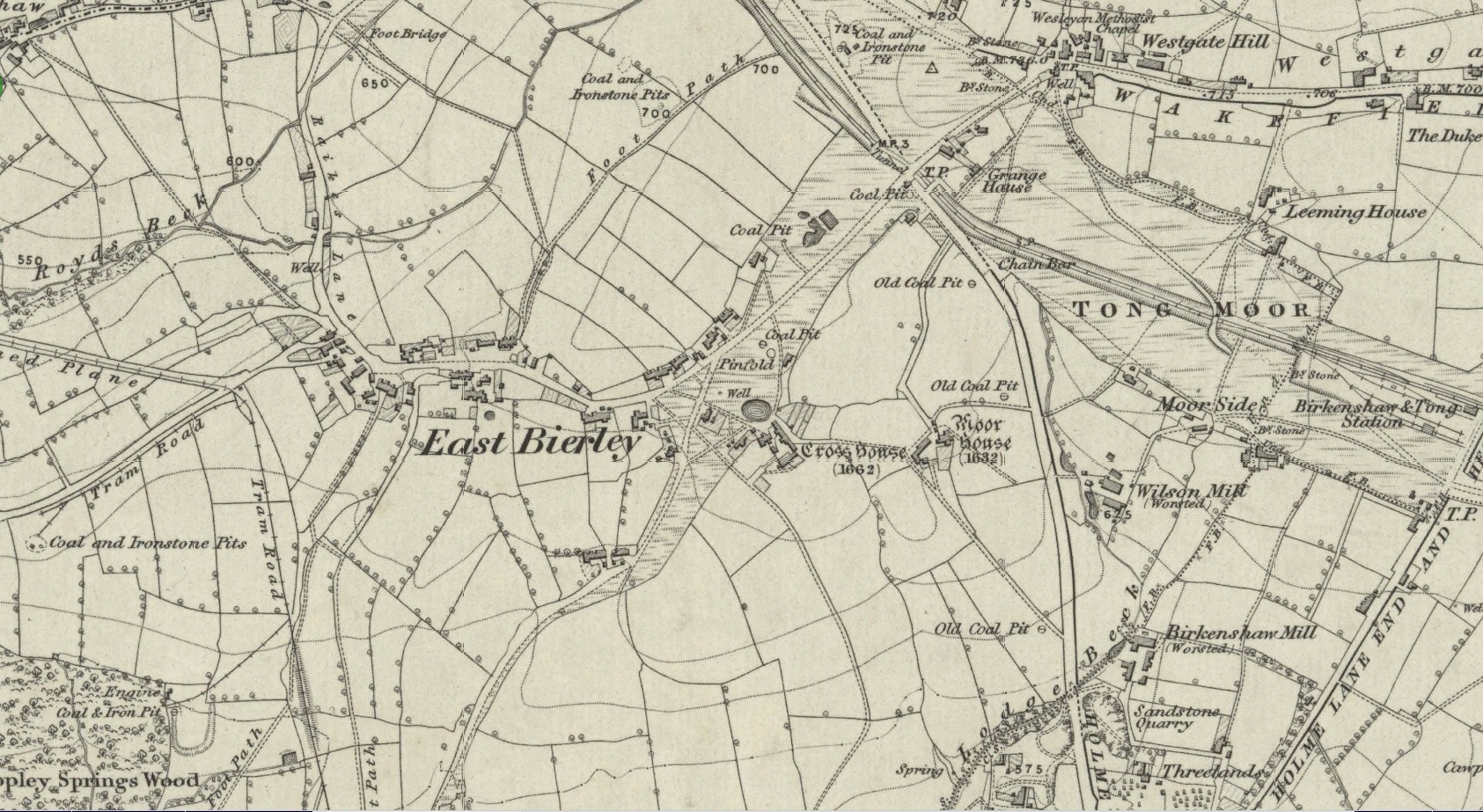
Site location at Cross House
Not to be confused with a much more renowned namesake above Ilkley, this was the name given to two old stones that once existed in the middle of the East Bierley hamlet (as it was then) southeast of Bradford. They were two large boulders next to each other, not far from the early farmstead of Cross House (see map, right) and were described in James Parker’s (1904) historic collage of the area, where he informed us that:
“On the village green (are) the primitive large stones locally called the “Cow and Calf stones,” which used to be in days gone by a Preaching Cross and Market Cross.”
When William Cudworth (1876) described the place nearly thirty years prior, he only mentioned a single cross, telling us:
“There is a lane which has long been called Kirkgate at Birkenshaw, leading up to an ancient cross on the hill. The fact of this cross being on the hill must have given rise to the name Kirk (church) gate, as there was not, until a few years ago, any church at Birkenshaw. In a previous paper we had occasion to notice the existence of the cross as an evidence of a pre-church period.”
The meaning behind the name Cow & Calf is unexplained by our respective authors, although Cudworth’s citation of “the cross as an evidence of a pre-church period” is probably not without merit here. It seems very likely that the animal names of the two large stones—akin to the Cow & Calf Rocks at Ilkley and others of the same name elsewhere in the country—that sat near the top of the hill, probably possessed a creation myth similar to others of the same name. From this, it seems logical that local folk held the rocks as important, which would have obviously attracted the regressive attention of Church—so they stuck a cross here to christianize the place and in doing so ensured that local people could continue using the place as a meeting place. This practice (as if you didn’t already know) was widespread.
Although Mr Cudworth seems to give the first real account of the place, field-name records of 1567 listed a ‘Cowrosse’, which may have been the “cross on the Cow” stone. A.H. Smith (1961) listed the site and suggested the element –rosse may derive from a local dialect word meaning a marsh, but a ‘cow’s marsh‘ seems a little odd. It is perhaps just as likely that an error was made in the writing of rosse instead of crosse.
References:
Cudworth, William, Round about Bradford, Thomas Brear: Bradford 1876.
Parker, James, Illustrated History from Hipperholme to Tong, Percy Lund: Bradford 1904.
Smith, A.H., The Place-Names of the West Riding of Yorkshire – volume 3, Cambridge University Press 1961.
High up in the landscape on the northwestern edges of Bradford, where we now find the Chellow Heights reservoirs, ancient man saw fit to place the remains of their dead. It’s in a damn good location too, typical of burial sites. The views to the immediate north are directly at Rombalds Moor where, as we all know, Bronze Age and other prehistoric remains are found in huge numbers.
It was during the construction of the Chellow Heights reservoirs when the site was uncovered. Twas here, in June 1921, where segments of three urns and,
“an incomplete incense cup, 2 inches high and 3 inches diameter at its base, were found together with partly burnt bones”,
of what were thought to be a young female adult. There are few other details. The fact that there was no mention of any covering mound, nor mass or stones, strongly implies that neither a tumulus or cairn covered these urns—and neither place-name evidences nor early maps indicate anything to suggest such a monument—so it would be fair to surmise they had been deposited in a stone cist.
References:
Barnes, Bernard, Man and the Changing Landscape, Merseyside County Council 1982.
Longworth, Ian, Collared Urns of the Bronze Age in Great Britain and Ireland, Cambridge University Press 1984.
Rowe, J.H., “An Ancient Burial at Chellow, near Heaton,” in Heaton Review, volume 2, 1928.
Sacred Well (destroyed): OS Grid Reference – SE 1589 3132
Archaeology & History
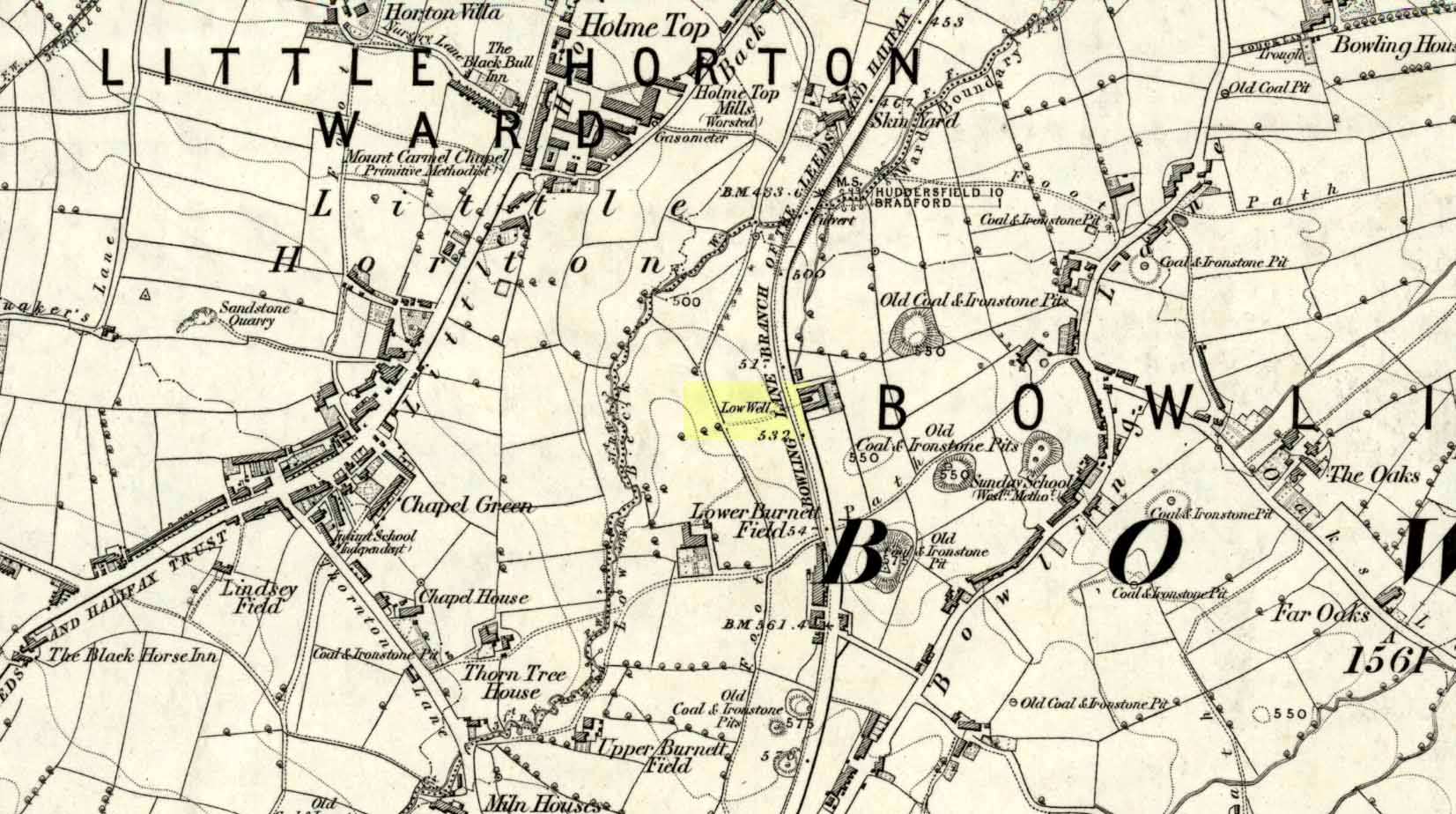
Low Well on 1852 map
Along the now-lost Low Well Road between Little Horton and West Bowling, could once be found this innocuous-sounding water source. Shown on the 1st OS-map of the area in 1852, the site was deemed to be little other than a ‘public well’. At the end of the 19th century, a small well-house was built over the waters; and the years following that saw its complete demise. Its name you would think relates to a position in the land, but the dialect word low, or lowe can mean “a flame, blaze, light, glow”, it can also refer to a prehistoric tomb. However in this case it most likely derives from “a pond or standing pool”.
…And if some of you wonder why I have given this so-called Public Well the provenance of being a “sacred well”, please keep reading…
Folklore
Although it was deemed a simple ‘public well’ by historians and the public water authority, local folk knew there was much more to it than that! In the Bradford area, this innocuously-named Well is the most promiscuously supernatural of all water sources, with a hidden history of magickians, ghosts and black dogs haunting its once ancient flow. It was a site remembered as having oracular powers, where local people used it in scrying the future. For such powers to work here, one had to gaze into the waters as they stilled at 6 o’ clock in the morning – a common time used by ritual magickians for the invocations of spirits.
The Bradford historian William Scrotum (1889) told us that in the 1860s, local people reported that the phantom black dog—or Bharguest as it was known—with its glowing red eyes, was seen coming out of the well after dark and scaring people half out of their wits. Very soon people would not even venture out after dark for fear of encountering this great harbinger of Death. Several years passed before local people called upon the abilities of a ritual magickian in the hope that he could lay the ghostly hound and bring peace and stability back to the hearts and minds of those living hereabouts. Eventually, after much work, the magickian exorcised the waters and cast the black dog back into the depths of the Earth from whence it had come and, to this day, sightings of the spectral hound have stopped.
Water sources that possess ingredients of hauntings, magic and oracular properties are universally ascribed as ‘sacred’ in one way or the other. In pre-industrial times I have little doubt that, amongst the animistic pantheon of local Bradfordians, this was no exception.
References:
Scruton, William, Pen and Pencil Pictures of Old Bradford, Thomas Brear: Bradford 1889.
Wright, Joseph, The English Dialect Dictionary – volume 3, Henry Frowde: London 1902.
Tumulus (destroyed): OS Grid Reference – SE 099 321
Archaeology & History
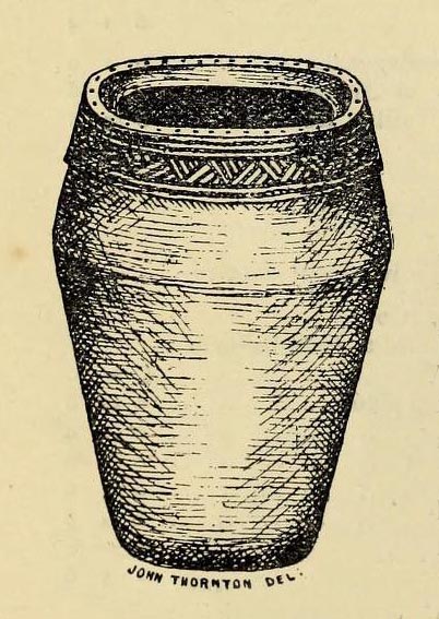
Headley Farm urn
There are no longer any remains of the prehistoric burial site that once stood in one of the fields by Lower Headley Farm. We don’t know whether the site was a cairn, a tumulus, or just a stone-lined cist; but in all probability it would have been a low rounded hillock whose existence had long since fallen out of oral tradition. All that we do know is that in one of the fields by the farm, some very well preserved urns—either neolithic or Bronze Age by the look of it—were unearthed, indicating a site of prehistoric provenance.
The finds were described only briefly in the first edition of the Bradford Antiquary (1888) journal, where it was reported:
“During the spring of 1880 an interesting discovery was made by Mr. Abraham Craven, quarryman, of Thornton. The ‘find’ comprised three funeral urns, which Mr. Craven turned up while baring a portion of a field in Lower Headley Farm, the property of the trustees of Sowerby Grammar School. The discovery was made within a short distance of the surface, the pottery presenting undoubted indications of pre-Roman origin. From evidence collected upon the spot, and the appearance of the pottery, two of the urns were about 14in in height, 9in across the top, 11½in at the widest portion of the bowl, and 6in at the foot. One of the urns was of sun-burnt clay, with rude markings, the other having evidently been subjected to fire. No coins, personal ornaments, or other indications of civilisation, were found in the urns, but each one contained human dust and bones. From the fact that several other urns have been met with in the immediate vicinity, equally rude in type, evidence is not wanting that the picturesque mound upon which Headley is situate was inhabited at a very early period of British history.”
References:
Anonymous, “Valuable ‘Find’ at Headley, near Thornton,” in Bradford Antiquary, volume 1, 1888.
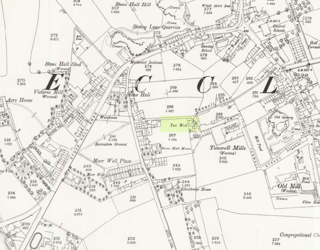
First mentioned in local history accounts from 1618—as the Tunwells—it was highlighted on the first OS-map of Eccleshill in 1851. Located on the aptly-named Tunwell Lane, it was a deep well covered by a large flat slab of stone, at the back-end the old Victorian mill. The stone was put there to prevent children falling into it. Some old locals thought the name of the place derived from a ‘tun’, or hundred, meaning it to be a hundred feet deep; although as A.H. Smith (1961) tells, tun could equally relate it to be one of Eccleshill’s town wells, of which there were several. It used to be one of the principal drinking supplies for the village and was said to rarely run dry. In William Ranger’s (1854) survey, he told this to be one of the sites to which local people relied in times of drought, where the land-owner allowed local folk to collect their supplies.
Folklore
The old cobbled Tunwell Lane was long ago supposed to be the haunt of a phantom black dog: a visionary precursor of death and Underworld guardian. Its spirit came and went into the deep well. I remember hearing tales of this when I was a young lad, as the old women who worked in the adjacent mills spoke of it. The ghost of a so-called ‘white lady’ was also said to walk along Tunwell Lane.
In more recent times, Val Shepherd (2002) included this in her short survey of wells in the area as being on “an alignment” with Eccleshill’s Moor Well and Holy Well. She thought “it may be part of a ley line”, but her alignment is inaccurate and doesn’t hit the spots.
References:
Crapp, H.C. & Whitehead, Thomas, History of the Congregational Church at Eccleshill, Watmoughs: Idle 1938.
Ranger, William, Report to the General Board of Health on a Preliminary Inquiry into the Sewerage, Drainage, and Supply of Water, and the Sanitary Condition of the Inhabitants of the Township of Eccleshill, George Eyre: London 1854.
Shepherd, Val, Holy Wells of West Yorkshire and the Dales, Lepus: Bradford 2002.
Smith, A.H., The Place-Names of the West Riding of Yorkshire – volume 3, Cambridge University Press 1961.
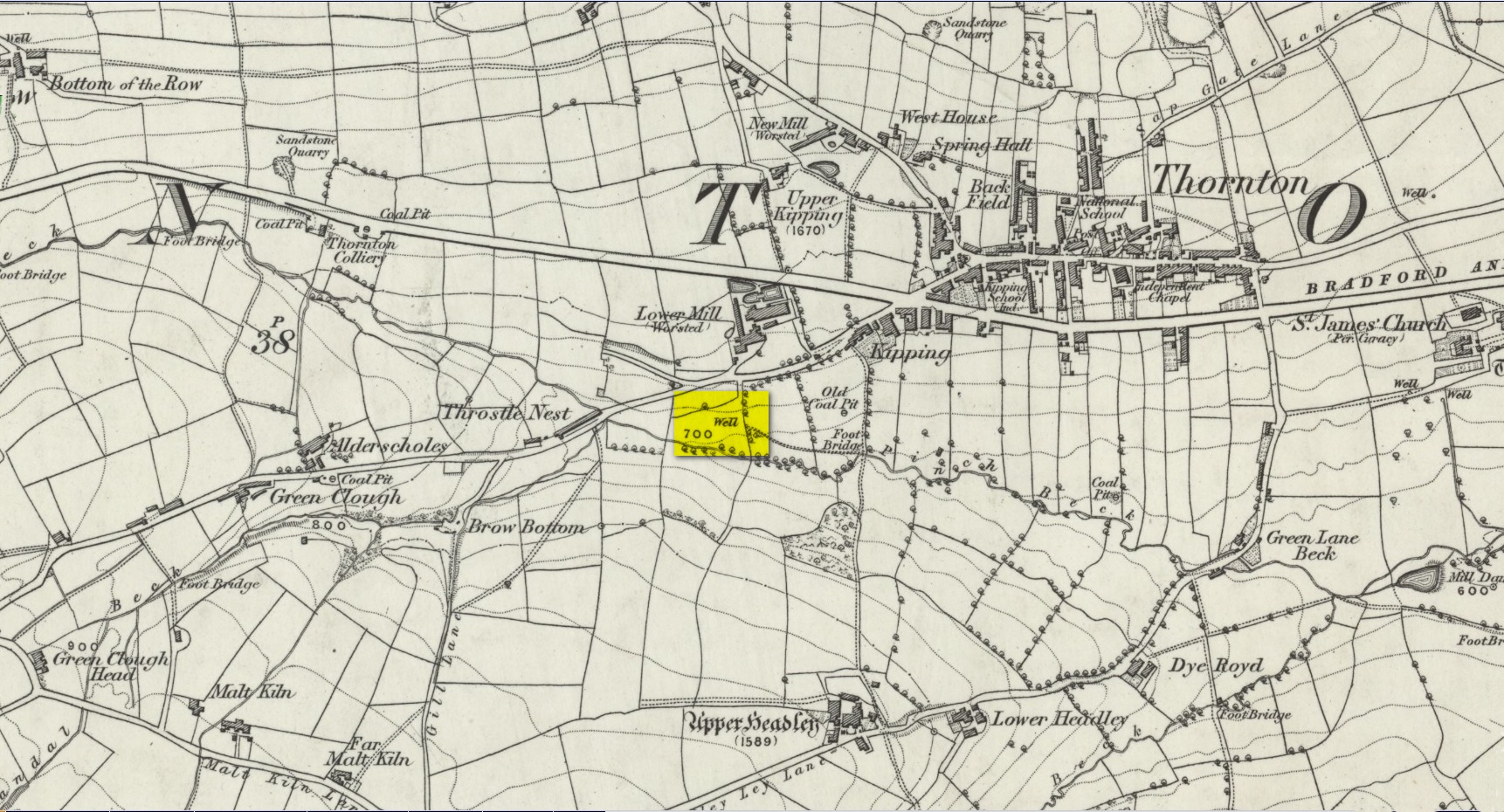
Another well with considerable supernatural renown was this little-known site near the old village of Thornton, on the western outskirts of Bradford. We’re not 100% sure about its exact location, but the grid-reference cited here is of an old ‘Well’ that was highlighted on the first Ordnance Survey map of the region, at the end of solitary path which led to it and nowhere else. Our only documentary information comes from Elizabeth’s Southwart’s (1932) fine old book on the folk life of the old village, as it once was. At a place once known as Bent Ing Bottom, just south of the old village, is where it used to be known. The name of this Well is also curious, as no historian has yet worked out who the ‘Jim Craven’ was, nor what his relationship to the site might have been. It’s the folklore of it, however, which brings it the attention it deserves.
Folklore
In Elizabeth Southwart’s (1923) work, she told us that the place once known as “Bent Ing Bottoms have lost their romance.” She continued:
“Whether the golfers have driven it away—for the fields now form part of the Thornton Golf Links—or whether the advance of modernity in other forms is to blame, it is difficult to say. Once they were the haunts of “Peggy-Wi-T’-Lantern” and the Bloody-tongue. Peggy, a dame in a white mob cap, kilted skirt and white stockings, walked about with a lantern, enticing the unwary traveller to his doom. She was given to wandering, for, they say, Jim Craven Well, half a mile away, was a place to be avoided after nightfall.
“The Bloody-tongue was a great dog, with staring red eyes, a tail as big as the branch of a tree, and a lolling tongue that dripped blood. When he drank from the beck (known as the Pinch Beck, PB) the water ran red right past the bridge, and away down—down—nearly to Bradford town. As soon as it was quite dark he would lope up the narrow flagged causeway to the cottage at the top of Bent Ing on the north side, give one deep bark, then the woman who lived there would come out and feed him. What he ate we never knew, but I can bear testimony to the delicious taste of the toffee she made.
“When the dark was coming we used to sit on the filled-in pit, which makes a hump in the middle of the field, and wait for him. The sun would sink redly, through the arches of the viaduct, the trees that lined the beck would grow an ever darker green until they became black, the beck would begin to gurgle and gulp in a queer way; and down in the hollow we would hear a whimper, a whine, a moan, a snarl. Then, with scalps and spines playing queer tricks, we would wait and wait. But none of our little band ever saw him, except one girl, and she saw him every time.
“One Saturday a girl who lived at Headley came to a birthday party in the village, and was persuaded to stay to the end by her friends, who promised to see her ‘a-gaiterds’ if she would. As soon as the party was over the brave little group started out. But when they reached the end of the passage which leads to the fields, and gazed into the black well, at the bottom of which lurked the Bloody-tongue, one of them suggested that Mary should go alone, and they would wait there to see if anything happened to her.
“Mary was reluctant, but had no choice in the matter, for go home she must. They waited, according to promise, listening to her footsteps on the path, and occasionally shouting into the darkness:
““Are you all right, Mary?”
““Ay!” would come the response.
“And well was it for Mary that the Gytrash had business elsewhere that night, for her friends confess now that at the first sound of a scream they would have fled back to lights and home.
“We wonder sometimes if the Booody-tongue were not better than his reputation, for he lived there many years and there was never a single case known of man, woman or child who got a bite from his teeth, or a scratch from his claws. Now he is gone, nobody knows whither, though there have been rumours that he has been seen wandering disconsolately along Egypt Road, whimpering quietly to himself, creeping into the shadows when a human being approached, and, when a lantern was flashed on him, giving one sad, reproachful glance from his red eyes before he vanished from sight.”
Southwart later tells us that the ghostly dog travelled into the north and vanished. From the description she gives of the children walking their friend to “the end of the passage which leads to the fields, and gazed into the black well, at the bottom of which lurked the Bloody-tongue,” I can only surmise that the solitary well shown on the very first OS-map of Thornton at the coordinate given above is the place in question.
The ‘Bloody Tongue’ is first mentioned in Yorkshire folklore, I think, by Roger Storrs, in his article on holy wells in 1888, where he tells it to be one of the mysterious beings that live, usually at the bottom of the waters and almost universally used “to deter children from playing in dangerous proximity to a well.”
From the description of the waters turning red when the ghostly dog drank from it, we have a mythic account of when the waters occasionally turned red from the iron-bearing waters (chalybeate) which, obviously, wasn’t like this at all times. Whether this was a sporadic, unpredictable flow of iron in the waters, or a cyclical pattern of the water-flows, we are not told (which would imply, moreso, that it was sporadic). The folklore about this ghost and its appearance with another elemental creature along an old straight track running north from Upper Headley Hall to Thornton is intriguing—as in many old pre-christian traditions, North is the airt, or direction, representing Death; and black dogs are traditionally guardians of underworld treasures in the land of the Dead. With the plethora of other animistic folktales once known in this district (boggarts or goblins were known in nearby woods, wells and farms) it is likely that the origin of such folklore dates way back into antiquity.
References:
Bennett, Paul, Ancient and Holy Wells of West Yorkshire, forthcoming
Southwart, Elizabeth, Bronte Moors and Villages: From Thornton to Haworth, John Lane Bodley Head: London 1923.
Storrs, Roger, ‘Legends and Traditions of Wells,’ in Yorkshire Folk-lore Journal – volume 1 (ed. J. Horsfall Turner) 1888.
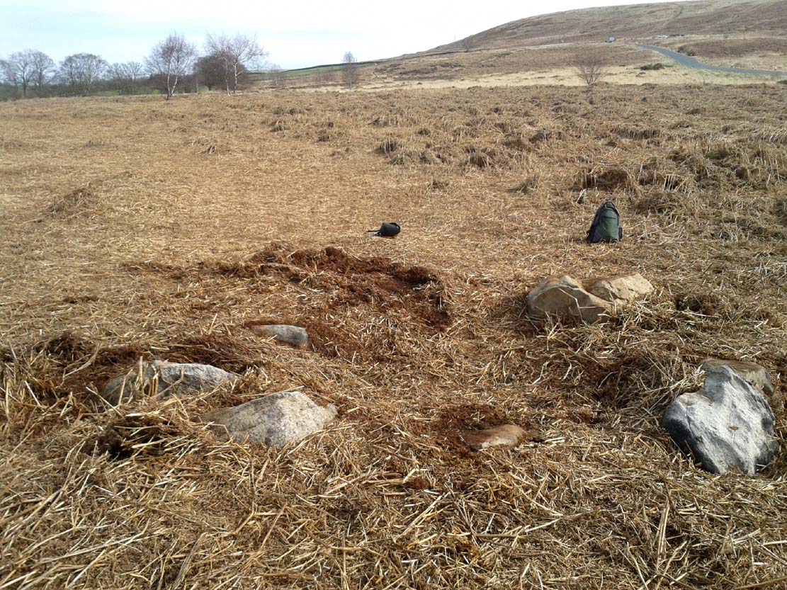
From the double-ring that is the Brackenhall Circle at Shipley Glen, go up the road towards the hills and seek out the cup-marked Glovershaw Quarry Stone. Shortly before this, notice the small trees close the quarry edge. From here, walk straight east, as if you’re going toward Baildon Hill. Barely 10 yards into the bracken you’ll notice this small ring of stones (best looked for in winter before the bracken grows back – otherwise you’ve no chance!).
Archaeology & History
This site was explored when James Elkington, Paul Hornby and I came across it on Wednesday, 11 March 2015, after returning from a short excursion to look at some of the petroglyphs on Baildon Hill.
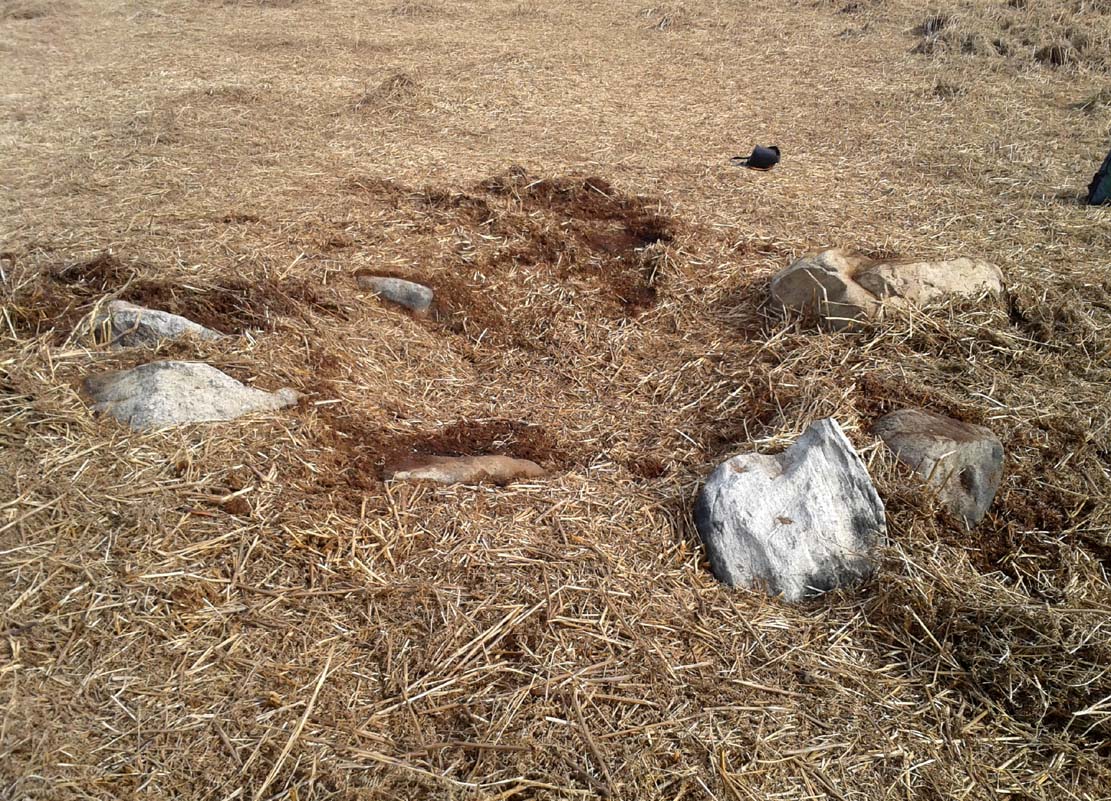
Ostensibly it is a small ring of stones comprising of at least 7 large rocks that are set deeply into the peat and bracken-mass, with a small eighth movable stone on the northern side. It seemed likely that another, larger rock was beneath this small portable rock, but we didn’t dig into the vegetative mound to explore this. The most curious thing about the ring of stones was that it measured barely 4 yards in diameter. My initial thought was that this was a previously unrecorded cairn, but there seemed to be no internal mass of rocks in the centre that characterize such monuments and which you’d expect in a ring of this size – meaning that it may be, perhaps, the smallest stone circle in Britain. It’s a pretty good contender at least! (the stone circle known as “Circle 275” at Penmaenmawr in Wales is of similar size to this one, but with less stones in that ring)
Close-up of the stones
It would be good if the regional archaeologists could give this site their attention and clean it up to see exactly what lays beneath the boscage. Close by are several cup-marked stones and a couple of other larger cairn circles.
The name of the site came after I almost stood on a hibernating toad, found beneath the bracken-mass right at the edge of one of the stones. I carefully picked him up and reburied him in another spot close by, leaving him (perhaps) to ponder his venture into the bright daylight of consciousness! Mr Hornby promptly declared – “these are the Toad Stones!” – and it stuck.
Not far from the old maypole, the Moor Lane Well was the innocuous-sounding site where legend told that a phantom horse was once seen running up and down the lane—said by old locals to be a “very ancient highway”. It was also a place where we find an intriguing tale of local disrepute, that brought humiliation to the culprit from the entire village.
There used to be a custom called ‘Riding the Stang’ which persisted in Yorkshire until the end of the 19th century. Thought to be of Scandinavian origin, it involved the culprit being hoisted onto a platform, held up by poles, then carried around the village where the person lived in a most ignominious procession. It was invariably described as being a public punishment and humiliation for faults made by one’s wife. Anyway, in the early 1840s, said H.A. Cadman (1930),
“there were two families who lived at Brecks Farm. I will not of course divulge their true names, so will describe one of them as the Jones family and the other as the Smith family. Jones’ wife accused Smith’s wife of having polluted the drinking water and the Smith family left the farm and removed to the top of Moor Lane. The Jones family wishing to make the most of the affair resolved that Mrs Smith’s effigy should ride the stang. A long pole was obtained and the effigy was affixed to the centre. Two men then took hold, one at each end, and walked up Moor Lane, folowed by a huge concourse of people. The procession stopped opposite Mrs Smith’s house and repeated the nominee. My informant, a dear old lady, would not tell me the whole of the verse, but it commenced thus:
“It’s neither your fault nor my fault that I ride this stang.”
“After all the verses had been repeated, the stang was taken round Gomersal, when ultimately the effigy was burned with the usual solemnities.
“The other instance of riding the stang occurred also in thge early ‘forties and I believe this was the last occasion of the stang being ridden. On this occasion a man…was in the habit of beating his wife harder than his neighbours thoughts proper with the result that he had to be punished. Now Jim was a most religious man, but the same rites had to be observed as in the other instance,
“It was for Jim Vasey that religious man
He paid her, he paid her indeed and
If Jim doesn’t alter his manners
We will take his skin “…….” to the tanners.
And if the tanner doesn’t tan it well,
We’ll send it to…”
“One must regret that the old custom of riding the stang has died out, as it must have had its good points.”
Local people could, of course, simply bring it back again! The Moor Lane Well was one of the main water supplies for the old villagers in bygone times, but seems to have disappeared under the modern houses. There is, however, a small narrow band of trees where the old waters once ran, amidst which it might still be found—if luck is on our side…
References:
Cadman, H. Ashwell, Gomersal, Past and Present, Hunters Armley: Leeds 1930.
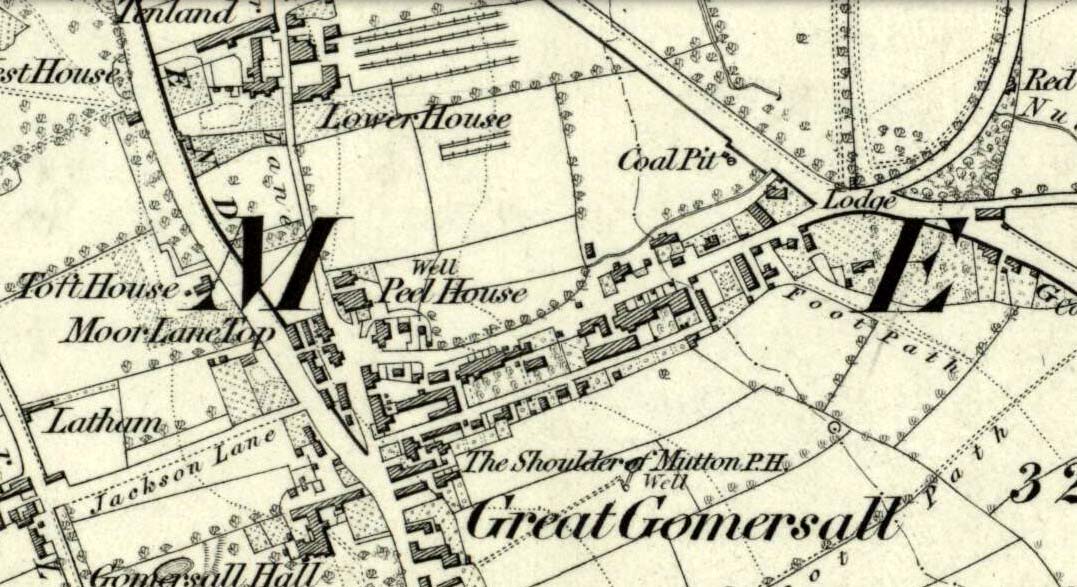
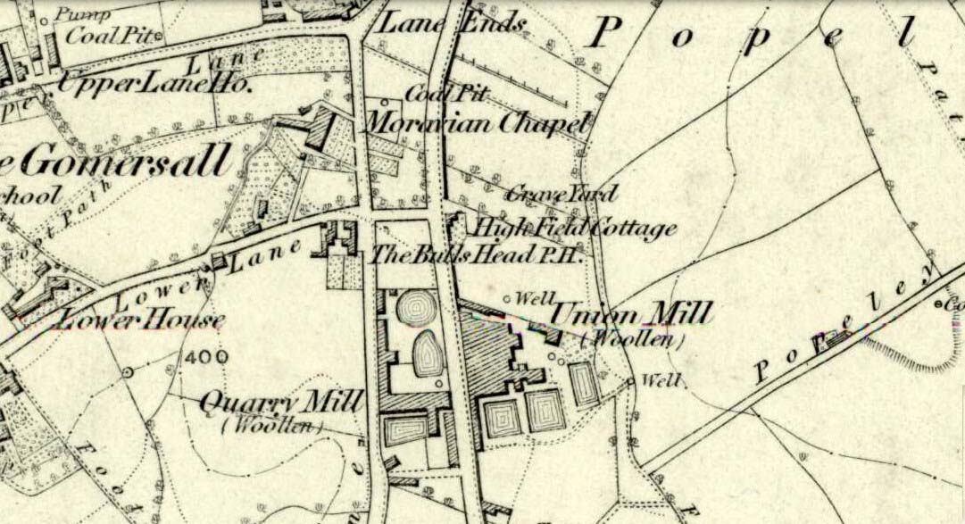
Originally called the ‘Manor Lea Well’ because it could be found on the far west of the land belonging to the Manor House, the name later became corrupted to ‘Mannerly’ by local folk. It was one of the four prime water supplies for this part of the old village, but it had other important social and festive rites attached that undoubtedly went back centuries. H.A. Cadman (1930) told that:
“On Palm Sundays it was the custom for boys to take bottles containing Spanish juice, treacle, and any other sweet thing they could, for the purpose of having them filled with the water from the well. The boys then exchanged bottles with each other and each sampled the others. It was said that no better water existed for this purpose.”
This particular ritual was integral to virtually every Spa Well from Wakefield through to the source of the River Calder.
A Mr G.W. Parker said that the well was to be found at the “extreme Western side” of Manor Lea and was “still in existence” when Cadman wrote about it in 1930, “behind Company Mill” not far from the Moravian Burial Ground. Do any local historians know if the well is still there, or has it since been destroyed?
References:
Cadman, H. Ashwell, Gomersal, Past and Present, Hunters Armley: Leeds 1930.
Healing Well (lost): OS Grid Reference – SE 209 260?
Archaeology & History
This bizarre-sounding well owed its name—if we are to accept H.A. Cadman’s (1930) version of history—to the local land-owner,
“Joseph Mortimer and it was so-called because Mortimer’s christian name was Doidy Poidy.”
But this seems unlikely. The term ‘doidy’ is a local dialect word, seemingly found only in West Yorkshire, meaning ‘an overdressed person, especially female,’ (Haigh 1928), with doidy-poidy being rhyming slang for the same thing. The english dialect magus, Joseph Wright (1900), proclaimed the same derivative, “a badly dressed woman, a dowdy.” So it may have been that this title was endowed upon Mortimer’s wife.
Cadman told that the Doidy Poidy Well was one of the “chief wells” of Gomersal, implying that its waters were good and strong. Its existence on what was known as “the old feasting grounds” may have played a part in the “public rejoicings which last for days… The feast was on the Monday on or before Lady Day.” (March 25th, around spring equinox) However, Cadman assures us that the celebrations were started “when the Gomersal Cloth Hall was opened,” telling us that “this feast or fair is not therefore an ecclesiastical one.”
The exact whereabouts of the Doidy Poidy Well remains a mystery (the map-link, above, shows an approximation from the middle of Gomersal).
References:
Cadman, H. Ashwell, Gomersal, Past and Present, Hunters Armley: Leeds 1930.
Haigh, W.E., A New Glossary on the Dialect of the Huddersfield District, Oxford University Press 1928.
Wright, Joseph (ed.), English Dialect Dictionary – volume 2, Henry Frowde: London 1900.