Go through the village of Stanbury, past the last of the two reservoirs until you’re on the western edge of Ponden. Stop and look up the slopes to your south. This spot was recently found and photographed by Richard Stroud: a curious-looking mound with all the hallmarks of being a forgotten tumulus. We’ve gotta check it out properly though!
Folklore
Although not in the archaeological records (not too unusual in Yorkshire it seems), the site does have some literary references and some all-too-common folklore motifs. Perusing my library for info about another nearby site (the Cuckoo Stones), I found the following said of this place in a rare book by James Whalley called The Wild Moor (1869, pp.103):
“It appears that some hills, as well as dales…have silvery names. There is a hill which is on the right hand on the way from Ponden House to Crow Hill Moor, which is distinguished by the beautiful designation of ‘Silver Hill.’ The hill is surrounded by a wall (I suppose to guard the treasure) and its surface is adorned with trees. Grey-headed men living on the borders of Crow Hill and Lancashire Moors affirm that during the Scotch rebellion here was deposited a large chest of silver, which was hid in the hill. It would appear as if the chest of silver is still there!”
This tradition was echoed a decade later by J. Horsfall Turner, and then again by Halliwell Sutcliffe in 1899, who reckoned the “vast treasure was said to have been buried during the ’45 rebellion,” adding how “the fields which climb this hill were well tilled aforetime through being constantly turned over in search of the treasure” – but nowt was ever found.
An additional bit of folklore tells of two spirits nearby: one of a man; another of a fiery barrel — either a remnant of earlier solar folk traditions hereby, or perhaps just an earthlight. One of these (the fiery barrel) rolled down the hill nearby; whereby the ghost of the man walked by the hillock along the track from Ponden House a little further east.
References:
Horsfall-Turner, J., Haworth Past and Present, J.S. Jowett: Brighouse 1879.
Sutcliffe, Halliwell, By Moor and Fell in West Yorkshire, T. Fisher Unwin: London 1899.
Stuck in the middle of the moor, at the bottom (southern) side of the Lippersley Ridge promontory. Head towards it from the Askwith Moor Road, along the track past Sourby Farm and onto the end. Then walk along the easy footpath which that takes you below the southern side of the ridge and, about 100 yards before getting to the end of the rise, look around in the heather. You’ll find it.
Archaeology & History
Graeme Chappell’s early photo of the carving
Graeme Chappell rediscovered this seemingly isolated cup-marked stone during one of our many exploratory ambles upon these moors in the early 1990s. The carving is a pretty simple one, consisting of between 10 and 12 cupmarks on the upper surface of a reasonably large elongated stone. No discernible rings or other lines seem to be visible. There are no other cup-and-ring stones close by; but two small prehistoric cairns can be found along the same sloping ridge east and west of here when the heather is low, and the larger Lippersley Pike Cairn stands out on the western end of the ridge 450 yards away. A more detailed exploration of this part of the moor may bring other previously unknown findings to light.
References:
Boughey, Keith & Vickerman, E.A., Prehistoric Rock Art of the West Riding, WYAS: Wakefield 2003.
In the superb work of the legendary J.R. Mortimer (1905) he tells what was found when him and his team excavated this “remarkable barrow,” as he called it. Although Mortimer’s contemporary researcher, Canon Greenwell (1877), also looked at the site, the “mound was covered with a clump of old fir trees” which prevented further examination at the time. Mortimer and his team seemed to have worked here when the trees had been felled and following “a three-week free use of the pick and shovel during July and August, 1878,” they opened up this prehistoric mound to see what lay within.
Their discoveries here were intriguing: for this wasn’t merely a burial site in its early phase but, moreso, a house of the dead no less, where the people whose bodies, or those who cremated ashes were deposited herein, lived in their spirit-life. It was an abode for the spirits of the dead. Mortimer’s lengthy notes tell the story:
“At the time of opening, it measured 4½ feet from base to summit, and the natural surface of the ground beneath it stood fully 1 foot higher than the present surface of the land for some distance round its margin. It was formed entirely of chalk rubble and soil, mainly obtained from an encircling trench, which on the northwest side was very deep and wide.
“We turned over the whole of this mound except its outskirts. Near the northwest margin there was an excavation (D on the plan) extending 8 to 10 inches below the base of the mound, and measuring 8½ feet by 6½ feet, the floor of which was covered with a film of dark matter, in which were small bits of burnt wood. No relic, nor the slightest trace of an interment was observed. A little west of the centre (at B) there was s still larger excavation, 18 inches deep. It contained rough chalk, but no traces of an interment. East of this was a third excavation (E), oval in form and 3 feet deep. Like the previous one it was filled with chalk and contained no relic or trace of a skeleton. The digging of these had preceded the erection of the mound, as there were no indications of it having been cut through. These excavations were doubtless graves, the bodies having entirely decayed.
“This was not, however, the case with the secondary and comparatively recent interments of six adult skeletons, found at the south-east side of the mound, 1 foot to 2 feet below its base. Though unaccompanied by any relic, the very narrow form of the graves and the extended and slightly flexed position of the interments alone showed them to be Anglo-Saxons.
“Below these secondary graves was an older and far more interesting excavation. Its form and position is shown on the plan at A. At first it was thought to be a huge grave, but as the work proceeded appearances indicating it to have served some other purpose were visible. Its filling-in was peculiar. It consisted of broken chalk, surface soil, and burnt wood, presenting altogether a very unusual arrangement. Along its centre for a distance of about 15 feet were six carbonized uprights of wood, 6 to 9 inches in diameter, at about equal distances and in a row. Wood ashes were also found on the sides and bottom, and scattered in the material filling the excavation.
“Also along the centre many of the large flat pieces of chalk stood on their edges, and at various depths were portions of animal and probably human bone, burnt as well as unburnt, and many fragments of a reddish urn. It was observed that the east end of this excavation became narrower and shallower. It now seemed evident that it was a habitation. Its form, as shown on the (above) plan, was oblong, with a ground floor 25 feet by 4½ feet; and its greatest depth was 6 feet. To its east end was a passage 11 feet long, gradually sloping to the surface.
“”On the south side, commencing at the inner end of the passage and extending inwards for about 12 feet, was a ledge or rock-seat, about 13 inches above the opposite side of the floor, as shown by the dotted lines in the plan and section. The whole width of the floor at the south-west end, for a distance of about 6 feet, was 10 to 12 inches above the centre and lowest part of the floor. The roof of the cave had most probably been formed of horizontal timber, supported by strong uprights of the same material, and then covered with a mound of earth and stones. The roof eventually gave way and the superincumbent earth and stones slid into the dwelling, several of the large flat stones…remaining on their edges.
“The abundance of wood ashes affords unquestionable evidence of the dwelling having been burnt. The preservation of the remains of the six uprights was due entirely to their having been completely charred. The fragments of red pottery are quite plain and belong to three or more vessels, which were probably used for domestic purposes.
“The roof of the cave must have fallen in long previous to the Anglo-Saxon interments, as where the skeletons were found, partly over the cave and partly upon the undisturbed rock, not the slightest distortion was visible, which would have been the case had not the filled-in portion under the bodies become firm. Near the south-side of the dwelling, at about the base of the mound, were several broken human bones and pieces of a dark-coloured urn. Probably these belonged to a disturbed Anglo-Saxon burial.
“We also found in the mound, between the graves E, B, D, a considerable quantity of detached animal and human bones; the latter indicated three or more individuals; a few of the bones showed traces of fire. There were also several small pieces of a dark plain urn.”
Mr Mortimer then commented on the unusual ‘habitation’ section within the mound, not thinking that the dead themselves “lived” here! But we can forgive him this small detail as his work in general was superb. The site was of course a decent East Yorkshire chambered tomb, wherein the dead were laid and, if entrance was ever possible by our tribal ancestors when it was erected, would have paid homage the ancestral figures buried here. Traditional death ceremonies were pretty inevitable I’d say.
References:
Mortimer, J.R., Forty Years Researches in British and Saxon Burial Mounds of East Yorkshire, Brown & Sons: Hull 1905.
Follow the same directions to get to the Dumpit Hill A stone circle; but instead when you get to the point where you need to walk off-track and into the heather to get to the circle, keep walking up the dirt-track for about another 200 yards, watching diligently thereby for a reasonable sized, fallen, “standing-stone”-like character just yards into the heather on your right (on your left, there’s a U-shaped dip where the wall is). This is the northern edge of the walled enclosure. From this fallen ‘standing stone’ follow the overgrown walling along carefully into the heather along and down the slight slope. You’re now either on the very edge, or perhaps going into the middle of the enclosure. Look around!
Archaeology & History
East section of walling
There’s no previous written history of this site, discovered for the first time last week on our sojourn to the Dumpit Hill stone circles, by Michala Potts. She didn’t seem too excited by it at the time, but an amble back to what she’d found got me going! (easily done) With the help of the heather being burned away, open and exposed was a distinct line of prehistoric walling — perhaps Bronze Age, perhaps later. It’s hard to tell.
Structurally similar to the enclosure walling at Horse Close and Rough Haw, either side of Skipton, a few miles to the south, here we have about 100 yards of walling seeming to enclose the eastern side of the small hilltop, but running into the heather on its southern edge and the moorland track on its northern side, where it disappears again, leaving no trace of what one would assume would be a consistent western section.
From the grid reference for the site, the line of walling runs northwards for about 20 yards before taking a very slight shift in direction for another 20 yards. Here the walling goes to the left (west) for another 20 yards, before edging slightly northwest and back into the heather. A section of the walling is visible at each end, though we lose any accurate trace of it after a short distance in the long heather. However, at the northwestern point in the enclosure walling, a very distinct long stone about 4 feet high leans at an angle in the ling. It seems apparent that this stone at one point in the not-too-distant past stood upright, making it the tallest stone here.
Northern section of wallingFallen monolith?
What may be other features can be seen inside this enclosure section: a possible hut circle and other portions of walling were noted. However, we didn’t spend much time exploring the site in detail, so there is a high probability of other prehistoric remains in and around this enclosure awaiting discovery. The site’s proximity to the stone circles of Dumpit Hill A and Dumpit Hill B should be noted; along with what the North Yorkshire’s Historic Environment Officer, Robert White, said were “three, possibly four small circular enclosures (about 9m in diameter)” a short distance away. A further survey of the site is necessary to enable us a better picture of what we’re looking at here.
Cup-and-Ring Stone: OS Grid Reference – NM 027 487
Also Known as:
Kettle Stone
Ringing Stone
Singing Stone
Archaeology & History
This is a fascinating large coastal boulder with around 53 cup-markings on it — but whether these are all man-made is a matter of debate. Some of them may be natural. However some of the cups have lines and faint rings around them, showing that at least they’re man-made; and also in one of the large cups are placed small pebbles, similar in form to the well-known Butter Rolls, or bullaun stone at Feaghna, Ireland.
Folklore
This large boulder (suggested to have been dragged and dropped here from the Isle of Rhum in an earlier Ice Age) is known in the modern tongue as the ‘Ringing Stone’ because, allegedly, if you knock the surface hard with another stone it supposedly chimes with a metallic noise. As one of the links below shows, however, it doesn’t necessarily do the trick! Local folklore tells that if the stone is ever destroyed, or falls off its present platform of smaller stones, Tiree itself will sink beneath the waves. Other lore tells that this great rock is hollow; and another that it contains a great treasure. According to Otta Swire (1964),
“Some believe this to be a treasure of gold, others claim it to be the resting place of the Feinn who there await the call to rescue Scotland.”
References:
Royal Commission on the Ancient & Historical Monuments of Scotland, Argyll – volume 3: Mull, Tiree, Coll and Northern Argyll, HMSO: Edinburgh 1980.
Swire, Otta F., Inner Hebrides and their Legends, Collins: London 1964.
The huge Pendreich Muir monolith, with Dumyat in the background
Nearly 600 yards west of the old Sheriffmuir Road (between Bridge of Allan to Greenloaning), you’re best approaching it up the zigzaggy lane from above Stirling Uni until it levels out beyond the main wooded area where the hills open up on either side of you. There’s a little touristy parking spot further along the road, just below a small wooded bit. Go past this and look out for the small peaked hill nearly a half-mile NW on your left. Take whichever footpath you fancy (if you see one) and get to the top of that hill!
Archaeology & History
This is a wonderful spot, located at the highest point on this small moorland region on the western edge of the Ochil Hills. I haven’t found too much written about this once proud, but now fallen monolith — which seems unusual considering its size, cos it’s huge! It would have stood out and been visible for miles around. Quite when it was felled, I cannot find. The only info I’ve got here (Royal Commission 1963) tells:
“Lying recumbent on a grassy patch among the heather, it is a four-sided pillar measuring 13ft in length, a maximum of 4ft 6in across the wider side, and a maximum of 1ft 6in across the narrower side.”
In enquiring about the nature of this stone a few years ago, a local chap who called himself ‘Wharryburn’ wrote to say, “I believe the laid-out stone is a fallen standing stone. My grandfather was gamekeeper at Airthrey Estate and responsible for the shooting on the moor there he passed it to my father etc… It’s the local volcanic stone, not an ice-dropped erratic. There are also a few biggish stones at points around that I tried to make some sense out of a few years ago, but no luck.”
The great hill of Dumyat rises to its east; a short distance north is a megalithic stone row with its upright Wallace Stone; whilst the overgrown prehistoric cairns of Pendreich 1, 2 and 3 live on the small hillocks a few hundred yards to the south.
References:
Royal Commission on the Ancient & Historical Monuments of Scotland, Stirlingshire – volume 1, HMSO: Edinburgh 1963.
Follow the directions to reach the Dumpit Hill A circle. From here walk about 100 yards ENE till you see an arc of small upright stones. If the heather’s in full growth it’s highly unlikely you’ll see anything; but if the heather’s been burnt away, the site’s worth looking at.
Archaeology & History
As with the small companion Dumpit Hill A circle more than 100 yards to the southwest, this site of similar dimensions was first reported by Arthur Raistrick in 1963, and then described — albeit briefly — in H.G. Ramm’s “Yorkshire Archaeological Register” for 1964, as “33ft in diameter. One third of the circle robbed but other stones standing.” And apart from that (with a repeat of the same info in Burl’s [2000] magnum opus) little else has been said. But there’s quite a bit more to this place than what our mentors have written…
Northern arc of circle, with stones A, B, C & DDumpit B Stone Circle (white sticks showing position of stones)
In a team visit to the site last week, it was Paul Hornby who called our attention to Dumpit Hill B. Thankfully the heather had been burnt back several months earlier, fortunately allowing us a better assessment of the place than Mr Raistrick’s initial survey forty years ago. Instead of just the 3 stones that he found here, we uncovered a near-complete ring of eight stones, arranged in a pretty decent circle (Alexander Thom would have classed it as a Type 1 circle). Paul’s attention was first drawn to an arc of three obvious upright stones and another laid down along the same arc. This arc then turned out to be a semicircle when he found another stone laid half-covered in the peat.
Western stones D & EStone F
But then it seemed, if this was an authentic stone circle, we were gonna struggle to see the rest of it as the deep heather had grown up over the southern side of this semi-circle of stones. But thankfully, with just a little bit of stomping on the ground in the right areas, three other stones of similar size and stature were located and within just a few minutes this small arc of stones had become a full prehistoric ring — except perhaps on the eastern side, where there was a distinct gap in the monument. Michala Potts and Paul did come across a couple of stones in this “missing” section, but they were just small rocks and didn’t account for an expected 9th stone. If such a stone ever stood at this eastern point in the circle, it remains unfound.
Two of the stones (G & H) that were initially covered in heather, after we’d carefully peeled the vegetation back, had what seems like small packing stones at one end, where it seemed obvious they had stood upright. It was tempting to carefully stand each stone back up into position, but we managed to overcome the temptation! None of the stones are higher or longer than 3 feet. At least three of them seemed to have been set along their longer axis rather than being set in the tall upright position — but again, this needs verifying by excavation. (With good evidence, some students posit that upright stones are male; rounded, wider stones are female — though such a lay-out here seems unlikely)
Stone GStone H
An additional curiosity was found in the middle of the circle, where there was a small but distinct scattering of stones, very much like a denuded cairn. If this turns out to be the case (as seems likely) it’d mean a new classification for this monument. We could do with having another look at this place the next time the heather’s been burnt away, enabling us to find out more about its nature and function.
…And if you walk west down the slight slope, over the couple of small drainage-ditch streams (which they really should stop cutting into our moorlands) and then up the slight slope towards the trackway, stopping some 20 yards before it, you’ll find you’ve walked right into the middle of a previously undiscovered Bronze Age enclosure, or settlement: the Dumpit Hill enclosure. It’s pretty impressive aswell! (more on that in due course)
References:
Burl, Aubrey, The Stone Circles of Britain, Ireland and Brittany, Yale University Press 2000.
Ramm, H.G., “Yorkshire Archaeological Register, 1964,” in Yorkshire Archaeological Journal, part 163, 1965.
ACKNOWLEDGEMENTS: Huge thanks again to Dave Hazell, Paul Hornby and Michala Potts in seeking out & helping with this and the adjacent sites!
From Grassington, head east along the B6265 road for a mile or so, thru the hamlet of Hebden and, once up the hill on the other side of the village, take the track up your left and walk up until the land just about levels out and the moorland opens up on the right-hand side of the track. If you’ve got the trackway which takes you to Scar Top House on your left (where the walling breaks), head straight into the heather and walk about 150 yards NE, keeping your eyes peeled for a singular upright, less than 3ft high. Once here, check the small overgrown ring you should be stood in!
Archaeology & History
A relatively small site that can be difficult to see when the moorland heather’s in full growth — but it’s in a lovely setting, with a hidden view of the hills for nearly 360°, yet quietly hidden from prying eyes until you’re all but upon the place. Although it has a likely Bronze Age pedigree (it aint yet been excavated), it was ignored by the confines of written history until Arthur Raistrick brought it back to life in a brief note in the Yorkshire Archaeological Journal of 1965 when Mr H.G. Ramm told what he’d found, described it simply as,
“32ft in diameter, 5 stones still stand leaving spaces where other stones have been taken for walling. A large stone is flat at the centre.”
Alignment east: ring, outlier, human, hill!
And that’s that! No doubt the remarks about some stones taken from here to be used in some walling were told Raistrick by a local, but he says no more about this.
The main feature to see in this small ring is the flattish, wide upright, less than three-feet high, on the eastern side. A smaller upright stands in half-boggy Juncus grasses as you spin round towards the north, with a smaller stone laid on the ground in between. Originally it appears there were at least eight standing stones making up this circle. If you walk around it you’ll make out several of the other stones laid down. About 30 yards due east of the tallest upright in the ring is another small outlying standing stone. And, less than 100 yards northeast from this outlier, we come across the equally small, little-known stone circle of Dumpit Hill B…
References:
Burl, Aubrey, The Stone Circles of Britain, Ireland and Brittany, Yale University Press 2000.
Dixon, John & Phillip, Journeys through Brigantia: volume 2 – Walks in Ribblesdale, Malhamdale and Central Wharfedale, Aussteiger: Barnoldwick 1990.
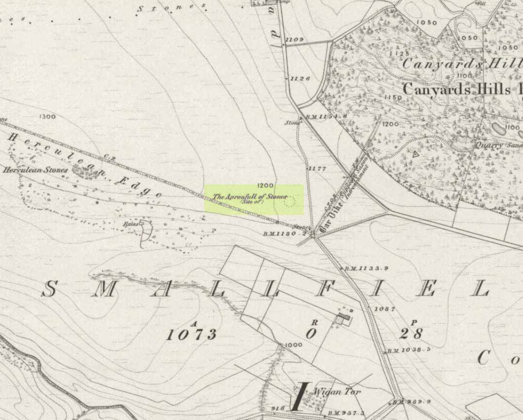
This was another example of the many giant cairns that scatter the upland moors on the Pennines, but much of it has been destroyed, with some halfwits in recent years cutting a track right through whatever remains there might have been! It was first described in John Watson’s (1776) essay on the local antiquities of Bradfield and district where, in relative conjunction with the curious Bar Dike, he told that “this is not the only curiosity on this common.” He continued: “there is on one part of it a large carnedde, called by the country people the Apron-full of Stones”, where he conjectured there laid a British tribal chief after he’d been slaughtered by the Romans. This might have been the folklore of the place, but we know such places were thousands of years earlier than the Romans.
It was later described in Joseph Hunter’s Hallamshire (1819) as a giant barrow, or ‘vast carnedde’, even then in the past tense; but some recent investigation here found “a few small stones and some lumpy turf which looked to be covering a few clumped stones.” The site requires further investigation by local people to assess the state of damage inflicted on this once great tomb.
Folklore
Said to have been the site of a local battle in ancient times; this is also another site which, as A.H. Smith (1961) tells, “is explained in folklore by tales of the devil undertaking some major building project and tripping up, only to deposit his apronful of stones” here. Does anyone out there have any more info on this place?
References:
Hunter, Joseph, Hallamshire: The History and Topography of the Parish of Sheffield in the County of York, Lackington: London 1819.
Smith, A.H., The Place-Names of the West Riding of Yorkshire, Cambridge University Press 1961-63.
Watson, John, “An Account of some Hitherto Undescribed Remains of Antiquity”, in Archaeologia, volume 5, 1776.
This lovely-looking 5-foot tall standing stone, marking an old boundary line in the Muasdale parish, is a curious one with elongated cups, some of which have the appearance of natural beach-side erosion caused by molluscs — unlikely though it may be. It first appears to have been described in an early PSAS article by Duncan Colville (1930), who told us:
“The writer was informed by the Rev. D.J. MacDonald, the minister of the parish, of the existence of this cup-marked stone forming a gatepost in the boundary wall between the arable and hill ground on the farm of Gaigean. The gate referred to is situated on the top of a steep bank on the south side of a small stream, a short distance uphill to the east of the farm steading of Gaigean. The front of a stone is now set an angle of about 45° to the ground facing almost southwest (105° magnetic across the face). Underneath the stone is another boulder similar in size, with several smaller stones wedged between the two, thus preventing further inspection.”
The North Beachmore stone
Some years later when the Scottish Royal Commission (1971) lads described the site in their Kintyre survey (monument no.97), they gave a more detailed description of the cup-and-rings, saying:
“The markings consist largely of plain cups, but one cup is accompanied by a partial single ring which measures 0.11m across. At the foot of the lower half of the stone four cups linked by broad gutters form a curious branched pattern, and a similar combination of three cups and gutters occurs in the upper half, while in two other instances a pair of cups are joined by a short straight channel to form a dumb-bell figure. The remainder of the markings comprise twelve oblong or kidney-shaped hollows measuring up to 0.15m in length by 0.064m in breadth, and thirty-one plain cups ranging from 0.038m to 0.076m in diameter, the largest being 0.019m deep.”
References:
Colville, Duncan, “Notes on the Standing Stones of Kintyre” in Proceedings of the Society of Antiquaries, Scotland, volume 64, 1929-30.
Royal Commission on the Ancient & Historical Monuments of Scotland, Argyll – volume 1: Kintyre, HMSO: Edinburgh 1971.


")