Dyke Stone, Burley Moor, West Yorkshire

Cup-Marked Stone:  OS Grid Reference –  SE 1395 4517

Getting Here

Sketch of the main design

Once you’re on Ilkley moorland itself, head over to the Little Skirtful of Stones giant cairn.  From here, walk due east for 115 yards where you’ll come across an overgrown dried-up (usually) dyke cut into the heath, which runs roughly north-south.  Walk over the dyke onto its eastern side and just a few yards in front of you, in a slight dip, you’ll found a female oval-shaped boulder amidst the heather.

Archaeology & History

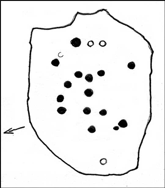
Rediscovered on Tuesday March 6, 2012, this medium-sized rounded (female) rock has somehow evaded all previous archaeological evaluations.  It is one of at least five previously unrecorded cup-marked stones found close to each other on the eastern section of Rombald’s Moor near the Little Skirtful of Stones.  The rock measures roughly 2 yards by 1½ yards and possesses at least 15 cup-marks that cover most of its surface.  Each cup-mark averages about 2 inches across and are less than ½-inch deep.  There is a natural ‘bowl’ in the southern section of the rock with a typical cup-mark in it and a smaller one in close association.

Dyke Stone cupmarks
and from another angle

The other cup-markings found close by, appear to be associated with the prehistoric cairns but this stone — the largest of the group — lacks any immediate relationship with such monuments.  Further ground explorations are required at other potential spots close by; plus we could do with getting back here when the sunlight’s better, so we can get some clearer photos!

© Paul Bennett, The Northern Antiquarian


Lanshaw Carving (335), Burley Moor, West Yorkshire

Cup-Marked Stone:  OS Grid Reference – SE 13440 45415

Getting Here

Carving 335, from above

From the Idol Stone carving, keep walking along the footpath that takes you up the hill and further onto the moor. Keep walking for another few hundred yards until you reach the old pits at Lanshaw Delves. Walk due east through the heather for 250 yards or so, until you hit the flat-topped cup-and-ring marked Lanshaw Stone. Walk 50 yards NNE from here, and keep diligent. You’ll find it!

Archaeology & History

…and from another angle

This is another carving which is troublesome to locate when the heather’s fully grown.  Like other cup-and-rings scattered along this geological ridge, it is associated with additional prehistoric features which local archaeologists have never bothered plotting: a real peculiarity, as this is a truly rich archaeological arena. Low walling and cairns are close by, all from the Bronze Age and possibly earlier. When we were children exploring this section of the moor, we also found a few flints scattered about (we threw ’em back into the peat, where they probably still remain).  The carving itself may be neolithic, but in all honesty until we get a decent archaeologist in the area willing to truly focus on our ancient monuments, we’ll never know the time periods of the remains here with any certainty.

When Boughey & Vickerman (2003) recorded this and other carvings nearby, they described it simplistically as:

“Medium-sized, rounded, triangular rock of medium grit, up to height of heather at centre. Two cups, of different size, and perhaps another.”

I’m not too sure about another to be honest, but I’d love to be wrong!  A curious straight line may run parallel to the cups, but this too may be natural.  I reckon the carving’s only gonna be of interest to the real rock-art fanatics out there.  But nearby, as you’ll find, are more impressive archetypal cup-and-rings…to be described later…

References:

  1. Boughey, Keith & Vickerman, E.A., Prehistoric Rock Art of the West Riding, WYAS: Leeds 2003.

© Paul Bennett, The Northern Antiquarian


Lanshaw CR-09, Burley Moor, West Yorkshire

Cup-Marked Stone:  OS Grid Reference – SE 13444 45444

Getting Here

Lanshaw Cup-marked Stone

A bit hard to locate. Take the route past the Haystack Rock onto the Idol Stone and Idol Rock, uphill, for a few hundred yards till you meet the distinct vegetational change and pits of Lanshaw Delves that run east-west. At this point on top of the path, walk to your left, due east, for 270 yards (247m), staying along the top of the ridge, then when you reach the flat-topped cup-and-ring marked Lanshaw Stone, head due north going down the heathery slope for about 50 yards until you find this reasonably large though flat earthfast stone. If you wanna locate it, you’ll find it!

Archaeology & History

Close-up of cupmarks

On an excursion that was exploring the relationship between prehistoric tombs and rock art in the area, this shallow carving was found that had, in a confusing way, been mis-catalogued in the archaeology registers – which confused us poor simpletons at the time!  Initial investigation indicated one primary cup-marking near the east-side of the stone, but when highlighted there was the possibility of another faint cup on the same section of the rock, just above the obvious one – but this still isn’t clear.

Cup-marks in better light

Found in association with other prehistoric remains close by, the carving is one that will probably be of interest just to those hardcore rock-art freaks amongst you.  However, there are a dozen other carvings close by, several of which are impressive cup-and-ring designs.  It’s one of around 50 cup-and-ring carvings on Rombald’s Moor that’s not in the Boughey & Vickerman (2003) survey — and this isn’t an easy one to see unless the lighting conditions are right.  This low rounded (female) rock has, since its initial discovery by the hardworking Mrs Potts, been stripped of its vegetation by members of the Ilkley CSI team when they found it for themselves.  Worth looking at if you’re exploring the other carvings nearby.

© Paul Bennett, The Northern Antiquarian


Brown Law (310), Ilkley Moor, West Yorkshire

Cup-Marked Stone:  OS Grid Reference – SE 13191 46512

Also Known as:

  1. Carving no.149 (Hedges)
  2. Carving no.310 (Boughey & Vickerman)

Getting Here

3 cups gently sleeping

Get to the Cow & Calf Rocks, go up across the car-park as if you’re gonna go up onto the moor and walk up the steep footpath uphill to the left of the crags.  Once you get level with the crags, take the footpath bending left and walk along here for 110 yards, keeping your eyes peeled for the low smooth rock on the right of the footpath, just where another path meets it. You’ll find it.

Archaeology & History

Close-up, from above

This quiet little stone has seen better days.  Nearly destroyed a few weeks ago when the Emmerdale Farm film-crew churned up sections of the moor right over the side of this carving—but thankfully it still remains intact (you or I would have been prosecuted for such damage).* The carving is a simple one in graphic terms, comprising simply of three cup-markings, all on the southern side of the rock.  Close to several other petroglyphs (the Wray Stone is 78 yards north and several other more ornate carvings are close by), the carving was first described in the Hedges (1986) survey as a “small, low smooth grit rock sloping slightly NW to SE in crowberry, bilberry, grass and bracken. Three clear cups.”  But it has to be said, one of them is fading fast.  Let’s hope this humble little carving doesn’t fall prey to those who are gradually turning our moorlands into a park.

References:

  1. Boughey, Keith & Vickerman, E.A., Prehistoric Rock Art of the West Riding, WYAS: Leeds 2003.
  2. Hedges, John, The Carved Rocks on Rombald’s Moor, WYMCC: Wakefield 1986.
* As the footpaths on Ilkley Moor continue to be widened and paved by those who reckon they like these moors, it’s obvious that more prehistoric sites up here are going to get damaged. It’s difficult to see what the local archaeologist or Natural England are doing to ensure that these environmentally-damaging schemes don’t encroach on the mass of rich prehistoric sites on the moors, most of which have never been adequately assessed (the philosophy of “if we don’t know it’s there, it doesn’t matter if we destroy it” seems evident in some of those working for the local council). Before any work or structures are dug on Ilkley Moor, an archaeological assessment is, I believe, supposed to take place – but I think this ‘work’ consists merely of looking at their own limited records, without any detailed fieldwork being undertaken. As we know from research undertaken by rock art students at TNA, CSI and elsewhere, there are still many cup-and-ring stones, cairns and archaeological features constantly being discovered on these moors that are not in the record books.

© Paul Bennett, The Northern Antiquarian


Beadle Hill, Extwistle, Lancashire

Earthworks:  OS Grid Reference – SD 8895 3420

Archaeology & History

The low hill called Beadle Hill is located about half a mile north of Swinden Reservoir between Worsthorne and Haggate in the area called Extwistle. It is just a short distance south of Monk Hall and a little east of Monk Hall farm. The earthworks are a long rectangular feature on a low hill (more of a mound really).

The earthworks are more noticeable on the south and west sides but less so at the eastern and northern edges of the mound. They can’t be said to be in any way defensive. The thinking is that this was a Romano-British farmstead or settlement from the late 4th century AD and, not as often thought a Roman camp. The name Beadle is apparently from the Anglo-Saxon/Old English word ‘Beado‘ or ‘Beadlo‘, meaning ‘battle.’  So could the hill be the site of some long forgotten skirmish from the time when the Romans were leaving the north of England? Or could it refer to the legendary ‘Battle of Brunanburh’ which was fought close by in 937 AD?  In that battle King Athelstan fought against, and defeated, the Danes and Scots who were moving south from Northumbria.

At the south side of Beadle Hill there is an ancient spring, and to the east is Twist Castle—a circular earthwork that could date from the same period as Beadle Hill.  Also, there are a number of tumuli and cairns in this area though these are prehistoric in date, probably Neolithic or Bronze-Age. I do not know whether the site has been excavated.  If it has, please let us know!

References:

  1. Cockburn, John Henry, The Battle of Brunanburh and its Period, Elucidated by Place-Names, Sir W.C. Leng: Sheffield 1931.
  2. Frost, Roger, A Lancashire Township – The History of Briercliffe-with-Extwistle, Rieve Edge Press: Briercliffe 1982.

© Ray Spencer


Thieveley, Holme Chapel, Lancashire

Tumulus (destroyed):  OS Grid Reference – SD 873 277

Archaeology & History

A prehistoric cairn or tumulus could once be found close to the grid-reference cited here, but all trace of it has long since been destroyed.  The site was mentioned briefly in Thomas Booth’s (1899) short survey on the prehistoric tombs of the area, telling:

“I have omitted to mention in its proper place a find which took place at Holmes Chapel about the year 1826.  The particulars are very meagre but, according to a local journal published some fifty years ago, called The Comet (edited by the late Abraham Stansfield), some workmen who were engaged in pulling down a barn at Thieveley discovered an ancient urn, whose contents were of a similar kind to those of other urns of this class.”

The “other urns” he mentions are those that have been found in prehistoric tombs on the north side of the same valley, including those at Cliviger Laithe, at Catlow, at Delf Hill and other sites close by.  Remains of another prehistoric cairn can be found close by on top of the hill at Thieveley Pike to the south, where a beacon was built, damaging the original tomb.

References:

  1. Booth, Thomas, Ancient Grave Mounds on the Slopes of the Pennine Range, R. Chambers: Todmorden 1899.

© Paul Bennett, The Northern Antiquarian


Carrot Hill, Inverarity, Angus

Cup-Marked Stone:  OS Grid Reference – NO 4545 4000

Getting Here

Newly found cup-marked stone

The stone is situated on the north-facing slope of Carrot Hill (almost equidistant with neighbouring Dodd Hill actually) at 225 m OD.  Use of a  GPS and the co-ordinates above are very definitely recommended for finding this stone which lies flat on a heather covered hillside.  You most likely won’t locate it without them.  There is ample car parking space at the popular viewpoint car park on Carrot Hill (NO 464 408), walk to the summit trig point and follow your GPS from there.

Archaeology & History

This cup-marked stone was first noticed in February 2012.   Remarkably, this stone seems to have been previously unrecorded despite lying just metres from a small path through the heather.

There are at least 15 cup marks on this sandstone boulder which was measured to be  1.2 x 0.7 x 0.2 m in size.  There is no evidence of any rings around any of the cups. 

The closest known examples of more rock art are just over four kilometers away to the west at Huntingfaulds where there is a cup and ring marked boulder.

© Stuart Anthony, 2012


Baildon Moor Carving (173), West Yorkshire

Cup-and-Ring Stone:  OS Grid Reference – SE 13844 40347

Also Known as:

  1. Carving no.40 (Hedges)

Getting Here

Carving 173, Baildon Moor

From Baildon go up onto the moor, turning left to go round Baildon Hill and onto Eldwick, stopping at the car park at the top of the brow where the Acrehowe circle once stood. Cross the road and walk along past carving 184, making sure you keep right sticking to the footpath that runs along the edge of the slope (not onto the flats & up to Baildon Hill itself). There are several carvings along here, but this one’s on the right-side of the widening path, another 300 yards past carving 184.  Keep your eyes peeled – y’ can’t really miss it!

Archaeology & History

Carving 173, looking S

In my 1982 notebook I described this as “a very well-preserved cup-and-ring stone, with two cup-and-rings and seven other cup-marks. There seems to be faint remains of other lines carved by some of the cups.”  And the description is as apt today as it was back then – though neither of the surrounding ‘rings’ are complete.  However, as the photos here indicate, adjacent to the main cup-and-ring near the centre of the stone another incomplete cup-and-ring is evident, emerging from the natural crack that runs across it.  In the subsequent surveys of Hedges (1986) and Boughey & Vickerman (2003) they somehow only saw one cup-and-ring on this rock.  Easily done I suppose!  In certain light there’s what may have been an attempted second surrounding ring starting on one of the cups…but I’ll leave that for a later date…

CR-173 (after Hedges)
Slippery when wet!

There may also have been intent to carve another ring around one of the other cups on the northern half of the stone.  This possible fourth ring and its position on the stone potentiates solar symbolism (not summat I’m keen on, tbh), which fits into the position and nature of several other cup-and-rings in this region and which I’ll expand on and highlight a little later on.  It is important to remember that this petroglyph and its nearby relatives were once accompanied by a series of tumuli, or prehistoric burial mounds: a feature that is not uncommon in this part of the world.  Well worth having a look at!

References:

  1. Bennett, Paul, Megalithic Ramblings between Ilkley and Baildon, unpublished: Shipley 1982.
  2. Boughey, Keith & Vickerman, E.A., Prehistoric Rock Art of the West Riding, WYAS: Wakefield 2003.
  3. Hedges, John (ed.), The Carved Rocks on Rombalds Moor, WYMCC: Wakefield 1986.
  4. Morris, Ronald W.B., “The Prehistoric Rock Art of Great Britain: A Survey of All Sites Bearing Motifs more Complex than Simple Cup-marks,” in Proceedings of the Prehistoric Society, volume 55, 1989.

© Paul Bennett, The Northern Antiquarian


Jeffrey & Joan, Portesham, Dorset

Standing Stones (destroyed):  OS Grid Reference – SY 6070 8701

Also Known as:

  1. Jefferey and Jone

Archaeology & History

Described in early field-name listings as ‘Jefferey and Jone’, this was another group of standing stones, whose precise nature is difficult to truly discern, that met with an untimely end in the middle of the 19th century.  They may have been part of a large tomb, or even a stone circle.  Marked on the early Ordnance Survey map of the area as ‘Standing Stones (site of)’, they appear to have been described firstly by John Hutchins (1774) close to other megalithic remains, who told that:

“A little north of Hell Stone near Blagdon are four upright stones, near to, and equally distant from each other, about two feet high, except that one is broken off even with the ground.”

In Warne’s (1866) classic text he mentioned these petrified monoliths,

“In a small valley, on the down of Portesham Farm, there stood within these last ten years, four upright stones… By the direction of the then occupier of the farm, Mr Manfield, these stones were built into an adjoining wall.”

A few years later another account by H.C. March, which referred to Mr Warne’s description, gave another report citing information from one who was present at the destruction of the site:

“Warne says they have been built into an adjacent wall: but a man who was present at the ceremony stated that, by the spot where they once stood, a hole was made for them, and they were decently interred.  The place where they are said to lie can be pointed out, as well as a wall which contains four large stones.” (Harte 1986:54)

Historian and folklorist Jeremy Harte (1986) concluded that the megaliths must obviously have been destroyed around the year 1855.  However, the historical references of Jeffrey & Jone being moved into the adjacent walling appears to be verified by independent researchers who’ve found standing stones hereby.

Folklore

Very probably the remains of petrified ancestors, a curious rhyme describes a forgotten folktale of these lost standing stones relating to them as possessing spirit, or once being alive.  They were thought of once as being a family who lived in the hills:

“Jefferey and Jone,
And their little dog Denty
and Edy alone.”

Sadly, I can find nothing further that might enrich the folktales that were obviously once spoken of these monoliths.

References:

  1. Harte, Jeremy, Cuckoo Pounds and Singing Barrows, Dorset Natural History & Archaeological Society 1986.
  2. Hutchins, John, The History and Antiquities of Dorset, John Bowyer & J Nichols: London 1774.
  3. Warne, Charles, The Celtic Tumuli of Dorset, John Russell Smith: London 1866.

© Paul Bennett, The Northern Antiquarian


Baildon Moor (184), West Yorkshire

Cup-and-Ring Stone:  OS Grid Reference – SE 14124 40447

Also Known as:

  1. Carving no.46 (Hedges)
Carving 184, Baildon Moor

Getting Here

From Baildon, take the road up onto the moors, turning left to go round Baildon Hill, then park-up at the small car-park on the brow of the hill at the edge of the golf course.  Cross the road and take the well-trod footpath diagonally right, heading onto Baildon Moor.  Walk along here for 300 yards and notice the large stone just to your right. You can’t really miss it!

Archaeology & History

Listed without real comment in several surveys, this large sloping rock that looks over the north and western landscapes of Rombald’s Moor and beyond, has several simple cup-markings on its surface, one with a faded ring around it.  In more recent centuries, someone began to add their own etching onto the stone but, thankfully, stopped before defacing the ancient markings.  I noted this carving in one of my early notebooks, saying only that it “lacked the central design found in others from this region,” being little more than a (seemingly) disorganized array of several marks.

Hedges 1986 drawing
Cups & faded ring

A greater number of other carved stones scatter the grassy flatlands west and south of here, some of which are found in association with prehistoric cairns and lines of walling; but no such immediate relationship is apparent with this particular stone.

References:

  1. Bennett, Paul, Of Cups and Rings and Things, unpublished: Shipley 1981.
  2. Bennett, Paul, Megalithic Ramblings between Ilkley and Baildon, unpublished: Shipley 1982.
  3. Boughey, Keith & Vickerman, E.A., Prehistoric Rock Art of the West Riding, WYAS: Wakefield 2003.
  4. Hedges, John (ed.), The Carved Rocks on Rombalds Moor, WYMCC: Wakefield 1986.
  5. Morris, Ronald W.B., “The Prehistoric Rock Art of Great Britain: A Survey of All Sites Bearing Motifs more Complex than Simple Cup-marks,” in Proceedings of the Prehistoric Society, volume 55, 1989.

© Paul Bennett, The Northern Antiquarian