Alcomden Stones, Stanbury Moor, West Yorkshire

Legendary Rocks: OS Grid Reference – SD 97313 35737

Also Known as:

  1. Oakenden Stones

Getting Here

The ‘druidic’ Alcomden Stones

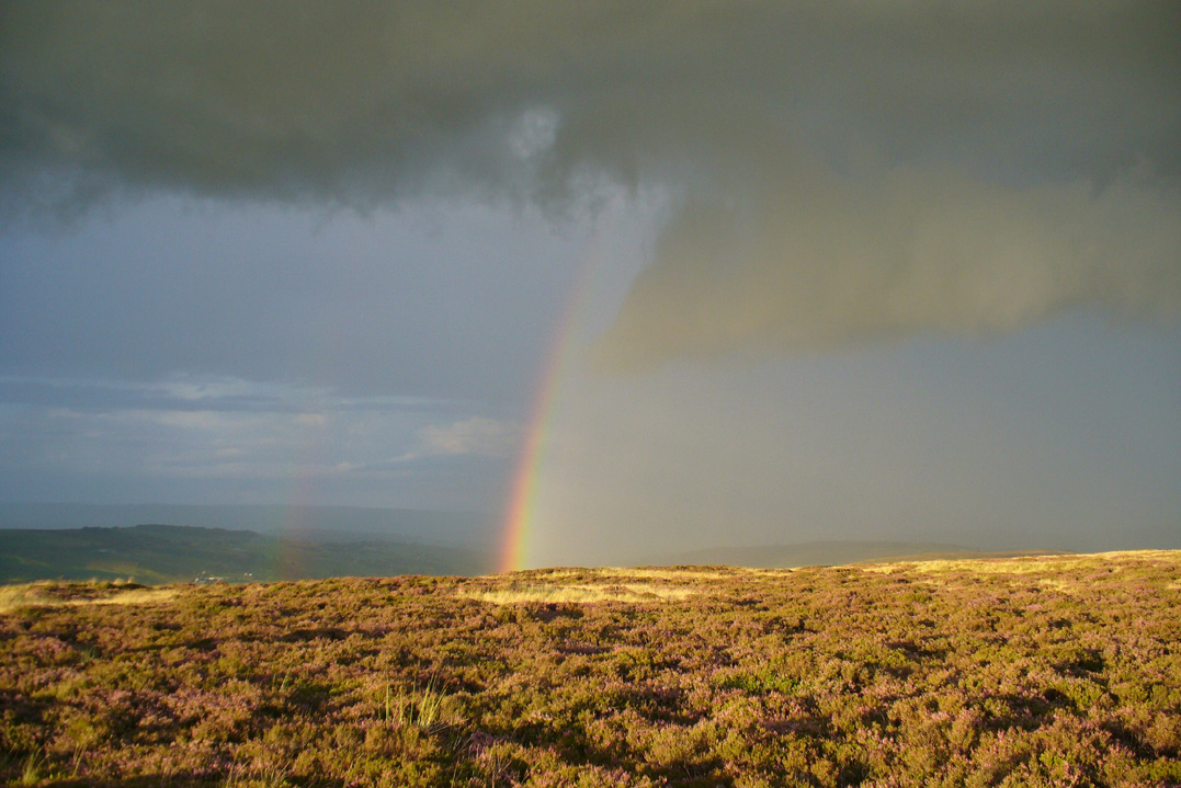
Takes a bitta getting to this spot, but it’s worth the effort!  Make a day of it and walk up here via the little-known Cuckoo Stones monoliths.  From here the walk gets steeper!  Follow the footpath from the standing stones, uphill, to the legendary Wuthering Heights building of Bronte-fame a half-mile ahead of you.  Then walk immediately up the slope at the side of the derelict house higher onto the moor (there’s no real footpath to follow) until the moorland levels out.  From here, look west and walk that way for a few hundred yards where you’ll be seeing a large rock outcrop ahead of you.  That’s where you’re heading! (if you reach the triangulation pillar, take the small path from there along the top of the moor towards this large rock outcrop)

Archaeology & History

Alcomden’s Altar Stone

To those of you who like a bitta wilderness, or healthy normal people I suppose, this is a stunning place!  Even though there’s little by way of archaeology here — save the usual expectations of a few flints and arrowheads — its geomancy, its position in the landscape, makes it excel as a once important ritual site for our ancestors in not-so-distant centuries.  Although local tradition gave these great rocks a prehistoric pedigree, the archaeological record doesn’t say as much — but that doesn’t really mean much up here.  We’ve found a singular Bronze Age cairn on the level at Middle Moor Flat 400 yards northwest (not in the record books), some prehistoric walling on the flat east of here (not in the record books), so a lot more attention is needed hereby to see what more may be hiding in this rocky heathland area.

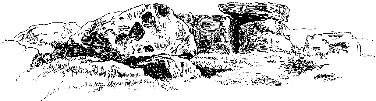
The main feature amidst this extensive scattering of rocks is the large rocking stone, said to weigh six- or seven-tons, resting upon other glacial deposits.  The rock itself can be made to rock very slightly.  It was described in Lewis’ Topographical Dictionary as a

“cromlech, an evident druidical remain, (which) consists of one flat stone, weight about six tons, placed horizontally upon two huge upright blocks.”

But the placement here was done by Nature and not humans — making it much more important to our ancestors.  This was a site for solace, for ritual and to commune with the gods themselves.  A few visits to this place show this quite clearly — unless you’re unable to relax that is! It’s a place I wanna spend more time working with, as the mythic history around these stones feels strong, despite their absence from written records.

The ‘altar’ resting on rocks
Alcomden’s “altar”

The druidic sentiments espoused by Lewis were all but echoed by our otherwise sober historian, J. Horsfall Turner, in his history of Haworth (1879), where he describes the Alcomden Stones as “the remains of a Druid’s Altar.”  On top of the main ‘altar stone’ are what could be ascribed as worn cup-markings, but it seems they’re Nature’s handiwork once again; though this wouldn’t deny them as having some significance to our ancestors.  A number of other boulders amidst this mass of rocks also have what seem like cup-markings, but none of them can be said with any certainty to have been carved by people.  Indeed, the entirety of this legendary rock outcrop seems to have been created solely by the spirits of Nature.

One view of Earth, from Alcomden
View of Earth, from Alcomden

It was first described as ‘Alconley’ in 1371, then in the 1379 Poll Tax returns as ‘Halcom’, the etymology of which is difficult.  Al- is a cliff or rock, many of which occur here; den is certainly a valley, over which we look to the northeast (to Ponden Kirk, 500 yards away); but the central element of ‘com‘ is the greatest puzzle.  Blakeborough (1911) tells of the old Yorkshire word ‘con’ — found in the 1371 spelling — meaning “to scan, or observe critically,” which one can certainly apply here in a topographical sense, i.e., “observation stones above a valley.”  It’s simple, succinct, and makes sense!

Folklore

As Elizabeth Southwart (1923) rightly said,

“Our forefathers, instinct and imagination more highly developed than knowledge, peopled their woods with fairies and their valleys with ghosts.  On the high, wind-swept spaces they built their altars to Unknown Gods.”

Turner's 1913 drawing
Turner’s 1913 drawing

And such she thought was done at this “heap of rocks called Oakenden Stones.”  It seems likely, as this place is superb for ritual magick and meditative systems.  But all we have are the repeats of numerous old historians, from Whiteley Turner (1913) and his namesake J. Horsfall, to James Whalley, J.W. Parker and more, who recorded what the old locals said: that is was a place of the druids.  There may be a grain of truth in it somewhere…

References:

  1. Bennett, Paul, The Old Stones of Elmet, Capall Bann: Milverton 2001.
  2. Blakeborough, Richard, Wit, Character, Folklore and Customs of the North Riding of Yorkshire, W. Rapp: Saltburn 1911.
  3. Parker, J.W., Guide to the Bronte Country, J.W. Parker: Haworth n.d. (c.1971)
  4. Southwart, Elizabeth, Bronte Moors and Villages: From Thornton to Haworth, John Lane Bodley Head: London 1923.
  5. Turner, J. Horsfall, Haworth, Past and Present, Hendon Mill: Nelson 1879.
  6. Turner, Whiteley, A Spring-Time Saunter round and about Bronte Lane, Halifax Courier 1913.

© Paul Bennett, The Northern Antiquarian


Rough Haw, Flasby, North Yorkshire

Hillfort:  OS Grid Reference – SD 963 558

Getting Here

Travel up the B6265 (Skipton to Grassington road) for a mile, watching on the small hills on your left (western) side, and then take the left turn up to Sandy Beck. You can’t miss the place!

Archaeology & History

Rough Haw, looking west

My first view of this place was from the hills east of here, atop of one of the great rock outcrops on the edge of Embsay Moor. The very first impression it gave me was – “That’s a bloody hillfort!”: an obvious worked rounded hill, with ridges typical of such monuments.  Subsequent investigation found that there were extensive remains of walling, more typical of the Iron Age period than the neolithic (which some modern archaeologists have proposed), clearly visible around the edges of this great hill.  The structure of the site is similar in size and design to the remains at the nearby Horse Close Hill above Skipton, aswell as another (officially unknown) site closer to Keighley.  A large overgrown cairn rests on the southern side of the hill, seemingly more of archaic import than a mere clearance or marker point. But I may be wrong…

Very notable at this site are the profusion of springs emerging from all round Rough Haw: the blood of seven such water sources comes from its edges on all sides and would obviously have been of some importance here.

References:

  1. Dixon, John & Phillip, Journeys through Brigantia – volume 1: Walks in Craven, Airedale and Wharfedale, Aussteiger Publications: Barnoldswick 1990.

© Paul Bennett, The Northern Antiquarian


Faweather, Baildon Moor, West Yorkshire

Cup-Marked Stone:  OS Grid Reference – SE 14263 41880

Also Known as:

  1. Carving no.48 (Hedges)
  2. Carving no.189 Boughey & Vickderman)
Sid Jackson’s early drawing

Getting Here

It is best approached from the track at the side of Weecher reservoir (site of the destroyed Weecher stone circle) on the east side of Rombalds Moor, where you should follow the natural curve of the track till you reach the tiny hamlet of Faweather where, on your right, just in the garden edge, you’ll see this faded old carving. This has only recently been incorporated into the garden (it used to sit on a small triangle of grass where three old tracks meet), but the people living here seem pleasant enough and will let you look at the carving if you ask.

Archaeology & History 

Hedges 1986 drawing

Just off the far-eastern edge of Rombald’s Moor and north of Baildon Moor, this faded cup-marked stone might only be for the real fanatics amongst you! I like it though.  Described in Sidney Jackson’s rare Bradford archaeology journal, the site was added to Hedges (1986) survey, and the subsequent Boughey & Vickerman’s (2003) work, neither of whom said much about it.  It’s a pretty basic carving though, consisting of several cups and lines that run over the top of the stone, some of which seems to be due to natural weathering — it’s hard to say for sure.

References:

  1. Boughey, Keith & Vickerman, E.A., Prehistoric Rock Art of the West Riding, West Yorkshire Archaeology Service 2003.
  2. Hedges, John (ed.), The Carved Rocks on Rombalds Moor, West Yorkshire Metropolitan County Council: Wakefield 1986.

© Paul Bennett, The Northern Antiquarian


Great Wood Laithe (019), Skipton, North Yorkshire

Cup-Marked Stone:  OS Grid Reference – SD 99620 50551

Also Known as:

  1. Carving no.3 (Hedges)
  2. Carving no.19 (Boughey & Vickerman)

Getting Here

Cowling’s 1964 drawing

From Skipton centre get to the Horse Close estate on the southern side of the town and look up to the fields on the sloping hill above it with the small woods above ’em.  Head up towards the trees, but before you get there go into the fields on your right, and in one of them you’ll see what looks like a pile of rocks near the middle.  Head for it!

Alternatively, follow the directions to reach the Horse Close Hill enclosure, then walk down into the field on its western edge.  You can’t really miss it!

Archaeology & History

This carving first saw the light of pen-and-paper in the early 1960s, soon after the Yorkshire antiquarian Eric T. Cowling (he of Rombald’s Way fame) was led to the site by his wandering nose and the aid of local people.  He sent a letter to the editor of the Bradford archaeology group at the time (a certain Mr Sidney Jackson), which told:

“South-west of the wood which gives its name to the Great Wood Laithe at the western end of Rombalds Moor and overlooking Skipton from the east, is a cup-marked boulder: NGR – SD 99625055.  In the middle of the field alongside the wood is an outcrop of rock which has been almost levelled with the adjacent field surface by the dumping of boulders from the surrounding ploughlands.

“The top of the outcrop rises to a dome-shaped projection which bears simple cup-markings.  These average two in diameter and total 17 in number.  The whole surface of the stone is weathered, and suitable light may reveal more details.”

And, faded though it is, in better lighting conditions it seems there may be more than twenty cup-marks on the rock.  Certainly this is what the surveys of Hedges (1986) and Boughey & Vickerman (2003) concluded.  There are other carvings close by and, on the hillside immediately above you, the denuded remains of a very impressive prehistoric settlement site known as Horse Close Hill.  Well worth having a look at!

References:

  1. Boughey, Keith & Vickerman, E.A., Prehistoric Rock Art of the West Riding, WYAS: Leeds 2003.
  2. Cowling, E.T., “Cup-and Ring Boulders,” in Cartwright Hall Archaeology Group Bulletin, 9:5, May 1964.
  3. Hedges, John (ed.), The Carved Rocks on Rombald’s Moor, WYMCC: Wakefield 1986.
  4. Ramm, H.G., “Yorkshire Archaeological Register, 1964,” in Yorkshire Archaeological Journal, volume 41 (part 163), 1965.

© Paul Bennett, The Northern Antiquarian 


Stanbury Hill (097), Bingley Moor, West Yorkshire

Cup-and-Ring Stone:  OS Grid Reference – SE 10970 43361

Also Known as:

  1. Carving no.78 (Hedges)

Getting Here

To get here, follow the same directions to reach the ornate Lunar Stone.  Once here, walk about 20 yards west towards where the brow of the hill begins to slope down.  Amble about and you’ll easily find it.

Archaeology & History

This is a fascinating carving.  Fascinating, inasmuch as it seemingly keeps changing appearance when Nature moves her daylight hues and whimsical unpredictability betwixt the hills, surrounding landscape and human observer.  Depending very much where you stand and when you look at this small rock — dappled with unacknowledged veils of sunlights, grey winds and other natural forces — determines what the stone shows you.  This carving as much as any upon this hill shows once again the hugely neglected dynamic between human purveyor and Nature’s powerful subtlety: an organic exchange of moods from stone to man and back again; very much how our ancestors saw things to be…

Pecked lines clearly visible on the far end of the rock
Carving from above

For if we were to merely pay attention to what the reference books tell us about this carving (good reference books though they are!), we’d simply be seeing a rock possessing a “cup and partial ring and two other possible cups”, as Boughey & Vickerman (2003) and other students might do.  But then, if conditions change, only subtly, and we gaze instead of study, other things can emerge.  And just such a thing happened when we came here yesterday…

On my first visit here I could only see a single cup-marking, with another ‘debatable’ close by.  The light of day wasn’t quite right it seemed.  But when we visited here yesterday, the sun, the light, the land and our ambling minds saw much more unveiled from this old grey surface.  Whilst two cups-and-rings seem to link with another cup on the lower end of the stone, amidst the natural cracks and fissures, on the higher end are very distinct carved pecked lines, one of which has been blatantly cut onto, or upon, the long curving crack which runs from one end of the stone to the other.  As this carved line emerges out of the natural crack, it heads upwards.  As it does so, another line has been pecked running off it to the left and then curves back down the sloping rock-face once again.  But in this previously unrecognised carved section, these lines may extend even further up the rock…..it’s hard to say for sure.  We could do with greater analysis of its surface, with further observations under yet more lighting conditions.

References:

  1. Boughey, Keith & Vickerman, E.A., Prehistoric Rock Art of the West Riding, WYAS 2003.
  2. Hedges, John (ed.), The Carved Rocks on Rombalds Moor, WYMCC: Wakefield 1986.

© Paul Bennett, The Northern Antiquarian


Baildon Moor Carving (169), West Yorkshire

Cup-and-Ring Stone:  OS Grid Reference – SE 13838 40138

Getting Here

Basic cup&ring design

From Shipley Glen, walk up to the Dobrudden caravan park on the western side pof Baildon Hill and then in the long grasses immediately north of here, on the Low Plain, this old carving could once be found.  I’m told it’s been moved in recent years (but have a mooch round anyway – there’s a number of other old cup-and-rings in the locale).

Archaeology & History

This small carving is not in its original position, having been moved to where it now sits a short distance northeast of the Dobrudden caravan park.  It was first described briefly in Mr Baildon’s magnum opus here, seemingly omitted from the Hedges (1986) and reclassified as ‘stone 169’ by Boughey & Vickerman (2003).  I’m not 100% certain that the illustration here by Joseph Rycroft and carving no.169 are one and the same – but they seem incredibly alike.  If anyone knows for sure, one way or the other, please lemme know and I’ll amend as necessary!

References:

  1. Baildon, W. Paley, Baildon and the Baildons – part 7, Adelphi Press: London 1913.
  2. Boughey, Keith & Vickerman, E.A., Prehistoric Rock Art of the West Riding, WYAS 2003.
  3. Hedges, John (ed.), The Carved Rocks on Rombalds Moor, WYMCC: Wakefield 1986.

© Paul Bennett, The Northern Antiquarian


Eclipse Stone (107), Bingley Moor, West Yorkshire

Cup-and-Ring Stone:  OS Grid Reference – SE 11164 42652

Also Known as:

  1. Carving no.107 (Boughey & Vickerman)
  2. Carving no.228 (Hedges)

Getting Here

From East Morton village, take the moorland road, east, and up the steep hill.  Where the road levels out there’s a right turn, plus (more importantly!) a trackway on your left which leads onto the moor.  Go up this track for a few hundred yards until you’re on the moor proper (by this I mean the track’s levelled out and you’re looking 360° all round you with all the moor in front of you).  Just before the track starts a slight downhill slope, go into the heather on your right, for about 80 yards.  You’re damn close!

Archaeology & History

I first came here many years back in my mid- to late-teens with an old school-friend Jon Tilleard, wandering about adventurously, occasionally stopping here and there when I found some stupid cup-mark or other seemingly innocuous scratch on the rocks, gerrin’ all excited and jumping about like a tit!  But when we visited the place again a few days back my response was somewhat different.  I was worse!  But for good reason…

Primary features of CR-107
Close-up of main features

The potential variations visible in this carving are peculiar, to say the least.  Ones first impression shows a carving similar in many ways to that shown in Hedges (1986) fine survey; but upon closer inspection a number of initial visual responses begin to look murky.  A seeming cup-with-double-ring aint what it seems!  To me at least (sad fella that I am!), it’s far more intriguing and far less certain, with a number of oddities still left.

The central feature of the carving is the lovely near-cup-and-double-ring!  As we can see in the photo here, there are some insecurities in the top-right of the outer ring.  To the upper right of this is another cup-with-partial-ring that was not included in the Hedges (1986) survey, nor Boughey & Vickerman’s (2003) updated work.  There are some obvious pecked carved lines — whose specific definition yet remains unclear — in and around this area of the petroglyph; but in the “official” illustration these elements or ingredients were somehow missed.

Eclipse Stone, looking west

When we visited the stone the other day, the naturally eroded lines on the rock seemed pretty obvious; but the more we looked, the less secure we were about some of them.  Thankfully the light kept changing about, allowing us to get different perspectives — and with the low sunlight of evening casting itself across the rock, some additional features seemed obvious.  In particular, what seemed like two natural “scratches” on the stone turned out to have been pecked and carved and the straight lines ran into the double cup-and-ring on the left-side.  One of these — the lower and shorter of the two — seems to run into the central cup, but this aint certain.  The longer top line has an even more circuitous venture: entering the outer ring, it passes onto the top-inner ring and then bends along its edge, before exiting again on the right-hand side, through the outer ring and heading out towards the large natural eroded cutting a few feet away (see my crappy drawing to get an idea).  Other faint aspects on this stone may have the hand of man behind them…

My shit sketch!
Hedges 1986 sketch

There are certainly a few other cups on the stone: one with a near semi-circle on its lower and right-hand side.  The long nature-worn cut, right-of-middle, may have had the hand of man cutting into the cup at the bottom; and another couple of “is it? — isn’t it?” enhanced natural cups seem possible on the left side of the rock.  There is also what looks like a distinct single cup-marking on the west-facing vertical face of the stone (you walk towards it from the track).  It looks pretty decent, but I’ll let them there “professionals” assess the validity or otherwise of that one!  But the other unmistakable and very curious ingredient is the deep, worn arc beneath the primary double-ring feature.  This is, as the photo shows, separated by a long natural crack running halfway down and along the stone, above which possibly the double-ring feature touches.  This large ‘arc’ feature gives the distinct impression of being a big smile!  However…

Turn the image of the central feature upside down and you get a very different effect indeed.  A rainbow above the surface of the Earth, with (perhaps) a pool in which the sun has reflected?  Or an underworld venture?  Looking at it from a few angles gives the impression of a comet moving across the sky, aswell as an eclipse with the diamond-ring effect.  But as with cup-and-ring in general, there are plenty of other potentials!  Which also begs the question: was it to be looked from the top or bottom (or left or right for that matter)?

I could waffle about this particular carving for much longer, showing that it had quite an effect on me.  Check it out and sit with it for a while… It’s superb!

References:

  1. Boughey, Keith & Vickerman, E.A., Prehistoric Rock Art of the West Riding, WYAS 2003.
  2. Hedges, John (ed.), The Carved Rocks on Rombalds Moor, WYMCC: Wakefield 1986.

© Paul Bennett, The Northern Antiquarian


Black Knoll Cross, Morton Moor, West Yorkshire

Cross:  OS Grid Reference – SE 1034 4465

Also Known as:

  1. Black Knowle Cross

Getting Here

Black Knoll on 1851 map

Get up to the Twin Towers right at the top of Ilkley Moor (Whetstone Gate), then walk east along the footpath, past the towers for about another 100 yards, looking out on the other side of the wall until it meets with some other walling running downhill onto Morton Moor.  Follow this walling into the heather for a few hundred yards.  Where it starts dropping down the slope towards the small valley, stop!  From here, follow the ridge of moorland along to your left (east) and keep going till you’re looking down into the little valley proper.  Along the top of this ridge if you keep your eyes peeled, you’ll find the stone cross base sitting alone, quietly…

Archaeology & History

This old relic, way off any path in the middle of the moor, has little said of it.  Whilst its base is still visible — standing on a geological prominence and fault line — and appears to taken the position of an older standing stone, christianised centuries ago, the site is but a shadow of its former self.  When standing upright may centuries back, the “cross” was visible from many directions. We discovered this for ourselves about 20 years back, when Graeme Chappell and I sought for and located this all-but-forgotten monument.  When we found the stone base, what seemed like the old stone cross lay by its side, so we repositioned it back into position on July 15, 1991.  However, in the intervening years some vandal has been up there and knocked it out of position, seemingly pushing it downhill somewhere.  When we visited the remains of the cross-base yesterday (i.e., Dave, Michala Potts and I) this could no longer be located.  A few feet in front of the base however, was another piece of worked masonry which, it would seem, may have once been part of the same monument.

Cross-base, looking north
Close-up of cross-base

Years ago, after Graeme and I had resurrected the “cross” onto its base, I went to visit the Bradup stone circle a few weeks later and found, to my surprise, the upright stone in position right on the skyline a mile to the northeast, standing out like a sore thumb!  This obviously explained its curious position, seemingly in the middle of nowhere upon a little hill.  This old cross, it would seem, was stuck here to replace the siting of what seems like a chunky 3½-foot long standing stone, lying prostrate in the heather about 10 yards west of the cross base.

Stuart Feather (1960) seems to be the only fella I can find who described this lost relic, thinking it may have had some relationship with a lost road that passed in the valley below here, as evidenced by the old milestone which Gyrus and I resurrected more than 10 years back.  Thankfully (amazingly!) it still stands in situ!

If you aint really into old stone crosses, I’d still recommended having a wander over to this spot, if only for the excellent views and quietude; and…if you’re the wandering type, there are some other, previously undiscovered monuments not too far away, awaiting description…

References:

  1. Bennett, Paul, The Old Stones of Elmet, Capall Bann: Chieveley 2001.
  2. Feather, Stewart, “A Cross Base on Rombald’s Moor,” in Bradford Antiquary, May 1960.
  3. Feather, Stewart, “Crosses near Keighley,” in Cartwright Hall Archaeology Group Bulletin 5:6, 1960.

© Paul BennettThe Northern Antiquarian


Tomb Stone (110), Stanbury Hill, Bingley Moor, West Yorkshire

Cup-Marked Stone:  OS Grid Reference – SE 11229 43143

Also Known as:

  1. Carving no.93 (Hedges)
  2. Carving no.110 (Boughey & Vickerman)

Getting Here

The larger stone in this cairn is the carved rock

From East Morton village, take the moorland road, east, and up the steep hill.  Where the road levels out there’s a right turn, plus (more importantly!) a trackway on your left which leads onto the moor.  Go up this track and keep walking till you hit a moorland ‘footpath’ signpost.  Just before this walk due west (your left) into the heather for about 10 yards.  Look around! (if the heather’s long and overgrown, you might have trouble finding it)  If you find carved stone 109, you’re less than 10 yards off this one!

Archaeology & History

First reported by Stuart Feather and described in a short note of the Yorkshire Archaeological Register* of 1977.  This was one of two small carved stones next to each other amidst the “denuded remains of a cairn 3m in diameter and 0.35m high.”  The stone we can still see here is a small one, seemingly near the very centre of the cairn, with its carved face looking northwards.  The carving is a simple double-ring surrounding a central cup: an almost archetypal cup-and-ring stone.

Crap photo of the double-ring

The other ancient carved stone that was once seen next to this (catalogued as carving 111) has in recent years been stolen by an archaeological thief no less!  Any information that anyone might have telling us who’s stolen this heritage piece, or where it might presently reside, can be emailed to me in confidence.  Or…the thief who’s taken it can return the carving to the site and put it back where it belongs before we find out where you live.  Simple as!

(Soz about the poor photo of this carving.  For decent ones of this stone you need to get here when the sun’s in a better position.  I’ll hopefully get some better images next time we’re up there when the light’s better.)

References:

  1. Boughey, Keith & Vickerman, E.A., Prehistoric Rock Art of the West Riding, WYAS 2003.
  2. Hedges, John (ed.), The Carved Rocks on Rombalds Moor, WYMCC: Wakefield 1986.
  3. Moorhouse, S. (ed.), “Yorkshire Archaeological Register: 1977,” in Yorkshire Archaeology Journal, volume 50, 1978.

* Does anyone have any idea who you report such new discoveries to so that they can be reported in Yorkshire Archaeology Society’s ‘Register’?  I’ve asked ‘em several times about a number of previously unrecorded sites that we’ve located, so that they can make a record of them, but I never get a reply.

©Paul Bennett, The Northern Antiquarian


Low Black Knoll, Morton Moor, West Yorkshire

Cup-Marked Stone:  OS Grid Reference – SE 104 445

Getting Here

Morton Moor carving

Takes a bitta finding this one.  From the Twin Towers at the top of the moors (Whetstone Gate), walk east along the footpath, past the towers for about another 100 yards, looking out on the other side of the wall until you meet with some walling running downhill onto Morton Moor.  Follow this walling for a few hundred yards till it drops down a small valley; then follow the valley down, keeping to its left-hand side, swerving a little round Black Knoll above you.  Cross the dried-up stream and about 100 yards ahead of you (southeast), heading towards the Sweet Well, zigzag about (once the heather’s grown back here, this’ll take some finding!).  Good luck!

Archaeology & History

Cup-markings, looking north

There’s no previous history to this site and archaeological records indicate no prehistoric remains in this region.  However, we (that is Dave, Mikki and me) found this and a number of other sites yesterday in a bimbling wander, to and fro, through boggy-heaths and deep heather.  It’s a previously unrecorded cup-marked stone, with what seems like an attached burial cairn right by its side (yet again!).  The cairn is 3 yards by 2 yards across.  Two very distinct cup-marks can clearly be seen near the top of the small stone, with a possible third just below.  A curious though natural yoni-like erosion can be seen on the lower side of the stone which may have some significance to people into that sorta thing!  Whether it had owt to do with the cup-markings is another thing altogether!

© Paul Bennett, The Northern Antiquarian