When water first emerges from the Earth they’re known as ’springs’ of water; those with stone troughs or basins into which the water falls are ‘wells.’ I don’t see much difference misself! And if water was of any importance to our ancestors (anyone who thinks it wasn’t is probably a bit slow…), such a clinical definition is of little importance. Many water-sites possessed great healing or therapeutic properties, as evidenced by chemical analyses (mainly in Victorian times, when a bittova craze on these wells was in vogue), aswell as folk-tradition, plus vast numbers of subjective encounters. To ancient societies – indeed, to myself – water is our blood, or the blood of the Earth. Treating this liquid as little more than a ‘commodity’, aswell as polluting it, should be a criminal offence – simple as!
My initial thoughts about this holy well, was that it had been destroyed—but thankfully I was wrong. It had been intruded upon by roadworks along the B9140, with the original water source affected, but it was re-routed and can still be found below the south-side of the main road. It was highlighted on the 1866 Ordnance Survey map of the area When the Royal Commission (1933) lads visited the site in 1927 they told that,
“It has no features of special interest. It is 4′ in diameter, but is so much filled up with stones and debris that it is now not more than 2′ deep.”
The site was mentioned in Ruth & Frank Morris’ (1982) survey, but with no additional information. I’ve not been able to find out whether the ‘lady’ of this well was a saintly woman of religious importance, or just one of us commoners! Does anyone know?
Royal Commission on the Ancient & Historical Monuments, Scotland, Inventory of Monuments and Constructions in the Counties of Fife, Kinross and Clackmannan, HMSO: Edinburgh 1933.
From Clackmannan Main Street, go down the Cattle Market and straight across at the junction, downhill. Keep going on the country lane for half-a-mile watching out for Grassmainston Farm on the left. Go past here and up the next dirt-track for a few hundred yards, watching out for a copse of trees on your left a coupla hundred yards away. Go to the very top corner of the copse, following the stream to its source. That’s it!
Archaeology & History
In a truly fascinating historical case of witchcraft (there was a lot of it in this area according to court and church records), heard in Clackmannan on 16th July, 1700, a certain spring of water, or well, was described, where acts of healing and sympathetic magick were performed and, it would seem, was quite well known to the people cited in the case. It seems very likely from reading the account, that the well in question had magical repute locally. The well was not named, but thankfully the information in the case has allowed us to identify the place in question. When I came here a month or two ago, the well was very overgrown (hence the poor photo above), so I’m gonna go back for another look at the place when Winter’s brushed back the vegetation.
The tale surrounding the well was included in Simpkin’s (1914) Folklore Society survey of Fife and Clackmannan a hundred years ago, and is as follows:
“John Scobie, younger, in Clackmannan, was called, who being of age thirty-eight, was sworn and interrogated if he went up with his uncle to a south-running well at Grassmainston. Deponed that he did go up with him, alone, the first night, and as his uncle was casting off his clothes at the well, the deponent saw a black man …coming from Kersemill; and when he came to the head of Robert Stupart’s folds there was a great squealing among the cattle. Also, when deponent had his uncle down to sprinkle him, he saw a brindled cat come out from among the corn within a little distance from him. He put magic powders upon his uncle when he was naked, which he had received from his said uncle’s wife, Margaret Bruce, who remarked to the deponent that the woman who directed (them), “would get a flee before he came back”; and that, at his return, at Goldney, he heard a terrible noise as of coaches, and that he was dripping of sweat when he came into the house.
“The said Margaret had forbidden them to speak in going or coming, which injunction they observed. When they came to call the deponent to go the second night he refused, till the deceased Robert Reid came and took him, and they both went with him, and saw the black man and the cat, and heard the cattle squeal as aforesaid and, when they were coming back again, there came a great wind upon the trees on the side of the Devon and, when he was crossing the Cartechy Burn his uncle’s foot slipped and he fell in the burn. Thereupon Robert Reid said, “The cure is lost. There is no helping of you now!” And so they spoke from thenceforth until they came home; for Margaret Bruce, the said James Scobie’s wife, told them that if he fell into the water he would not be cured. The witness further added that when they told Margaret that her husband had fallen into the water, she wept. ”
The magickal well in this case would appear to be one identified at the very top of the small copse of trees immediately north of Grassmainston farmhouse, just 3-400 hundred yards away up the slope. It is a “south-running well” as cited in the case and no other water source is immediately apparent. It would be good if any students or antiquarians living near Alloa could check local library records and see if there’s any further information about this site. A short distance north of here is the curiously-named ‘Serpent Wood’, with its old well, fallen stone and lost legends…
…to be continued…
References:
Simpkins, John Ewart, County Folklore – volume VII: Examples of Printed Folk-Lore Concerning Fife, with some Notes on Clackmannan and Kinross-Shires, Folk-Lore Society: London 1914.
Along the main street running through Alva, towards Tillicoultry, watch out for the roman catholic church on your left, then shortly past it the house of St. Serfs. Just next to this is the small road called Lovers Loan. Walk up here and just before the graveyard, walk right, into the overgrown boggy marshlands. The first presence of the holy waters here are about 12-15 yards into the grasses, where you’ll walk right into it!
Archaeology & History
A sacred well that was named after the little known character of St. Serf, who was said to have been the hermit and tutor of the more renowned St. Mungo.
Highlighted on the 1866 Ordnance Survey map of the area as St. Servanus’ Well, 100 yards southeast of the church, it was included in MacKinlay’s (1893) fine survey, though without comment. However it was said by Mr & Mrs Morris (1982) to be “near the south entrance of the churchyard.” The boggy remains of the spring can indeed be found at the southern edge of the graveyard, up Lovers Loan, just below the edges of a large mound. In Mrs Drummond’s (1936) survey of Alva, she too told that the “Well of St Servanus”,
“contained healing waters and was still to be seen in St. Serf’s Glebe in 1845, nbut it is now just a marsh on the west wisde of the lower cemetrary gate.”
The original waters have in fact been completely capped and the well is now covered by a modern concrete block, standing right next to the resurrected remains of one of Alva’s remaining standing stones.
References:
Drummond, Mrs A., The History of Alva and District from the Early Christian Period to 1900, in Transactions Stirling Natural History & Antiquarian Society, volume 58, 1936 (reprinted by Clackmannan District Libraries 1981).
MacKinlay, James M., Folklore of Scottish Lochs and Springs, William Hodge: Glasgow 1893.
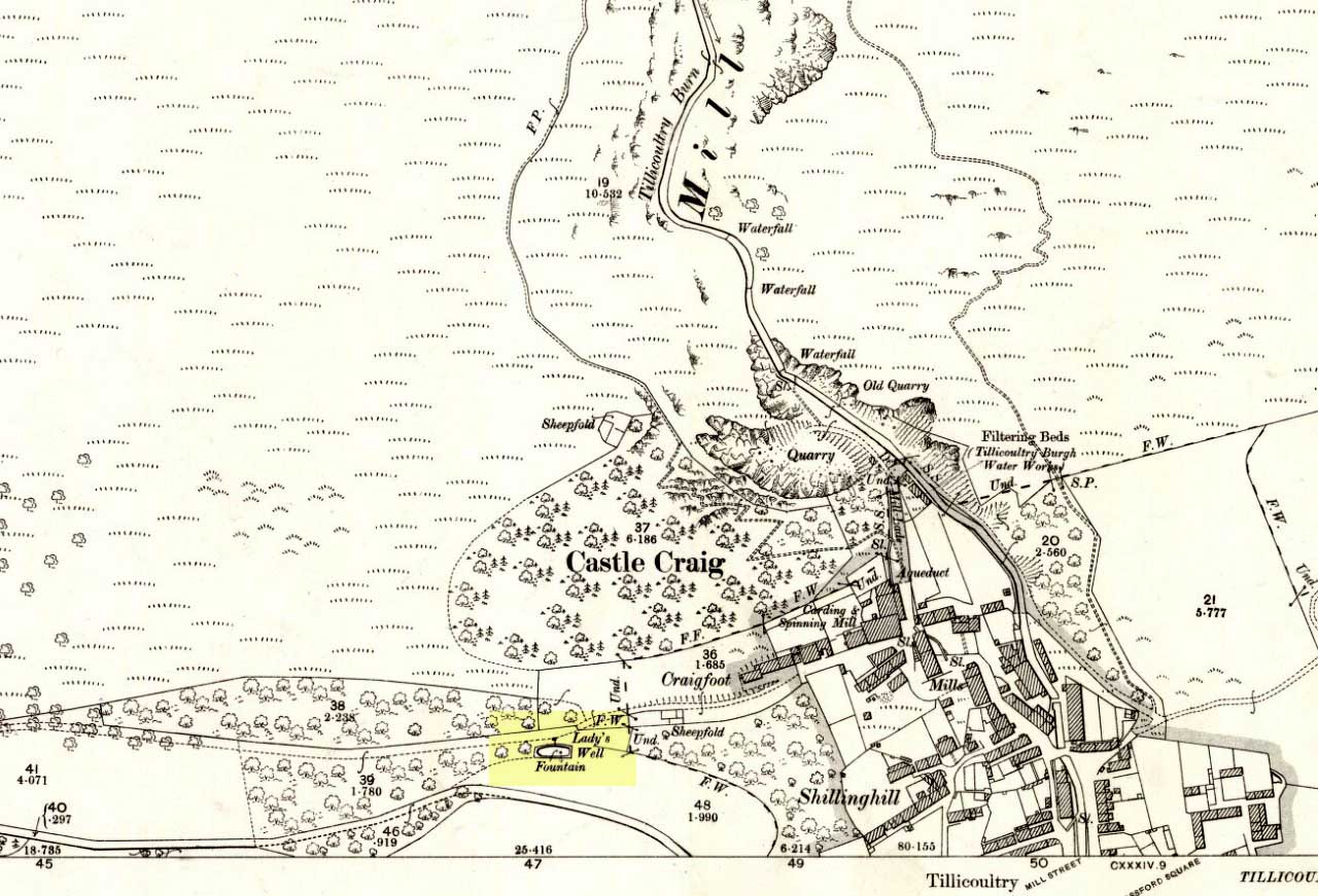
From the main road running through the town, head west towards Alva, and where the golf course begins, take the footpath uphill at its edge which heads towards the giant quarry. Where the dirt-track begins, keep walking along the edge of golf course, noting that where the open field starts, a gate on your right. Go through this, and walk up the side of the fence for some 30 yards, then go through the large gate. 10 yards in front of you, note the small stream crossing the track, and a scatter of overgrown rocks just on the other side of the wire fence. You’re here!
Archaeology & History
Thought by Angus Watson (1995) to have been possibly dedicated to ‘Our Lady’: in this context it’s difficult to know whether the dedication was to the christian Virgin, or to the heathen ‘Lady Alva’, whose web of snow and other natural garments clothe the mountains and glens of the Ochils hereby.
The first account of the place seems to be in William Gibson’s Reminiscences (1883) where he told that,
“In the year 1839, a Mr John Henderson built the only woollen mill…the water for the steam engine of which was got from the Ladies Well”,
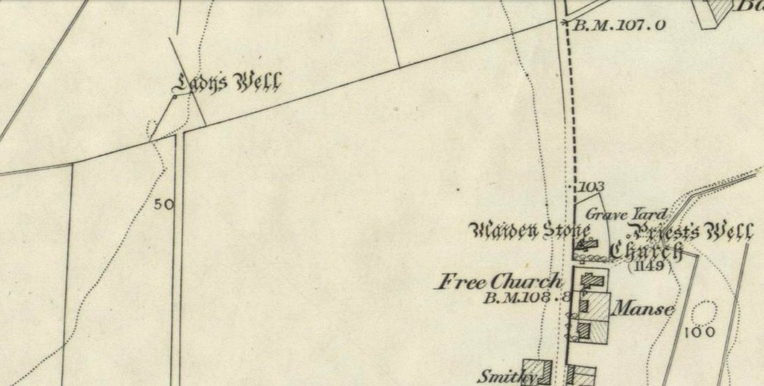
Ladys Well on 1899 map
which was barely 100 yards to the west. It was later highlighted on the OS-map in 1899 with an associated ‘fountain’, right by the track-side. A water-pumping station shown at the same time on another map was, of course, the one that was built to supply the mill with water.
The present water source is slightly higher in the field than when it was shown on the early OS-maps, and it does still flow continuously—although the source is much neglected and could do with being recovered: as the photo here shows, an ugly pipe appears to be taking much of the healing waters which are now mainly feeding a large pond in the garden just below.
References:
Gibson, William, Reminiscences of Dollar and Tillicoultry, Andrew Elliot: Edinburgh 1883.
The holy well/spring can be reached by following the Worsthorne road south from Haggate to Cockden Bridge over the River Don, then following the footpath due east beside the river for about a quarter of a mile. At the Ormroyd footbridge where the River Don becomes Thursden brook head in a north-easterly direction up the hillside. The well, or what’s left of it, can be found beside a trackway.
Archaeology & History
Around twenty-five years ago Calf Hey Well was described as being a square-shaped structure made of five stone slabs, one of which makes the roof. The water, which most probably had some form of mineral content, bubbles up into the large square basin which is a little lower than ground level. Today, the well is still there but I don’t know in what condition it is.
Folklore
According to Clifford Byrne in his book The Holy Wells and Mineral Springs of N.E.Lancashire,
“Calf Hey Well is a strong spring which rises out of the hillside, but in medieval times it was believed that the waters here had special qualities. Some people thought it was a holy well and reputedly many people visited Calf Hey on holy days when jugs of water were sold. A few accounts state that stalls were set up on a flat piece of land to the west of the well, Here vendors not only sold water but other things (food, religious objects and trinkets) and a market atmosphere must have pervaded the site”.
In 1819 the local water company took over the well and began to use its supply of water for the ever growing population of Burnley a few miles west of here. After this the fairie people were never seen again at the well – they were probably feeling very indignant at what had transpired.
Folklore has played its part here too. Fairies are said to have inhabited the well in days gone by – indeed they were often seen dancing around the well in the moonlight. These fairies or “little people” were not just creatures of the night which our ancestors delighted in when they could catch a rare glimpse of them. In fact these little people were quite normally formed although small in stature. Though not human they had the capacity to intervene in our human affairs – usually but not always for the good of it. They were known to steal little children and babies, supplanting them with their own offspring. So the parents of newly born babies had to be very vigilant and get their babies baptised as quickly as possible.
There are a few lesser-known wells in the same area as Calf Hey. These include The Jam Well at Worsthorne, Sweet Well at Holden Clough and Robin Hood’s Well at Black Clough, Thursden.
References:
Byrne, Clifford, The Holy Wells and Mineral Springs of Northeast Lancashire, MS copy in Nelson Public Library (Reference).
Frost, Roger., A Lancashire Township – The History of Briercliffe-with-Extwistle, Rieve Edge Press: Briercliffe 1982.
From Ilkley centre, take the road up to Cow & Calf, going past the hotel and along Hangingstone Road for a half-mile until you meet some walling on the right of the road. Stop and walk up the small beck, veering to the left as you approach the brow of the hill. Keep walking up the beck onto the moor where you’ll eventually reach its source, as shown in the photo here!
Archaeology & History
This once fast-flowing spring of fresh sparkling water has seen better days. The site has two openings in the Earth about 10 yards east and west of each other, both discernible by the notable difference in vegetation on the moors here, where richer hues of green created by the waters cut a small channel down the moorland slopes through the usual hues of heather.
The waters taste fine when they’re in flow, but much of the land here has fallen into shallow marsh and with the inevitable falling of the water table thanks to the stupid arrogant Industrialists, very little of the goodness is available. But it wasn’t always like this. Certainly when our prehistoric ancestors carved the rock art close by the source of the waters, then later constructed the large ritual enclosure immediately west of the springs, the waters would have been very important—and in much greater profusion—for simple nourishment and for rituals enacted at the site.
Whether you’re coming here from either Baildon, or Shipley, head for the Cricketer’s Arms on Green Road (ask a local). About 50 yards uphill from the pub, on the other side of the road, notice the small pool on the green surrounded by large rocks. That’s y’ spot!
Archaeology & History
First illustrated on the 1851 6-inch to the mile Ordnance Survey map of the region, this little known medicinal spring of water appears to get its name from the northern dialect word, crutch, meaning a plough, a plough-handle, a spade and variants thereof. (Wright 1898) There is another possibility of it deriving from “an ash or hazel pole” that were given as payment to workers each day in bygone times—a curious custom in itself! But we actually don’t know for sure and could even assume that people came here on crutches to be cured, or something along those lines.
The place has clear running water and had a chapel built near it in the early 19th century. The old public house across the road (Cricketer’s Arms) has spring water from this well running underneath it, which was said to never run dry and also keeps the drinks forever cool in warm weather! A few yards above the source of the spring, on the grass to the north is a small cup-marked stone. Another cupmarked rock listed by archaeologists as a prehistoric carved stone nearby on the same grass verge is probably of more recent industrial origin.
References:
Baildon, W. Paley, Baildon and the Baildons – parts 1-15, Adelphi: London 1913-1926.
Wright, Joseph, English Dialect Dictionary – volume 1, Henry Frowde: Oxford 1898.
Healing Well (lost): OS Grid Reference – TQ 315 817
Also Known as:
Fagge’s Well
Archaeology & History
First described in local church records from around 1190 AD (Webb 1921) as Fageswelle; then again a few years later in early crime records of the region (Hardy & Page, 1892) as Fackeswell, there were a number of other references to this lost water source, which could once be found near the Skinners Well and the more famous Clerks Well, Finsbury. Gover, Mawer & Stenton (1942) believed the site owed its title to some long-forgotten local name, though could give no specifics. (i.e., they didn’t know!) The old dialect word ‘fag’, relating to old grass is as good a meaning as any!
The site was described by John Stow in his Survey of London, 1603, saying it was “near unto Smithfield by Charterhouse, lately dammed up.” In Mr Foord’s (1910) excellent work on the subject, he told that,
“In 1197 certain lands are described as lying between the garden of the Hospitallers and Smithfield Bar, “super rivulum de Fackeswell,” and other lands as between that brook and ‘Chikennelane’… This fixes the position of Faggeswell Brook as approximately at the boundary of the City.”
Further information about this site would be much appreciated. The grid-reference for this site is an approximation.
References:
Foord, Alfred Stanley, Springs, Streams and Spas of London: History and Association, T. Fisher Unwin: London 1910.
Gover, J.E.B., Mawer, Allen & Stenton, F.M., The Place-Names of Middlesex, Cambridge University Press 1942.
Hardy, W.J. & Page, W. (eds), A Calendar of Feet of Fines for London and Middlesex, 1197-1569 – volume 1, Hardy & Page: London 1892.
Sunderland, Septimus, Old London Spas, Baths and Wells, John Bale: London 1915.
Webb, E.A. (ed.), The Records of St. Bartholomew’s Priory, and of the Church and Parish of St. Bartholomew the Great, West Smithfield – volume 1, Humphrey Milford: Oxford 1921.
Healing Well (lost): OS Grid Reference – TQ 313 822
Archaeology & History
Like oh so many of the healthy old springs and streams in that dreadful metropolis, the blood and natural health of Skinner’s Well was killed long ago by the self-righteous arrogance of Industrialists. Even its precise whereabouts seems to have been forgotten… So we thank the written words of antiquarians to keep its memory alive.
Mentioned as far back as 1197 AD in early fine records of the region (Hardy & Page, 1892) as Skinnereswell — and thereafter in various local history records from 1200, 1244, 1385 and constantly from thereon — the place-name authorities Gover, Mawer & Stenton (1942) told that the prefix ‘skinner’, “clearly derive from personal names,” from “the occupational name skinner, of Scandinavian origin.” But this isn’t to everyone’s etymological fancy! When A.S. Foord (1910) sought for information on this healing spring, he found the same 1197 account, in which
“Skinners’ Well is there described as lying in the valley between the Nun’s Priory and the Holeburn, in which was a large fish-pond… Strype, in his continuation of Stow’s Survey (1720) say, ‘Skinners’ Well is almost quite lost, and so it was in Stow’s time. But I am certainly informed by a knowing parishioner that it lies to the west of the church (of St. James, Clerkenwell), enclosed within certain houses there.’ The parish would fain recover the well again, but cannot tell where the pipes lie. But Dr Rogers, who formerly lived in an house there, showed Mr Edmund Howard…marks in a wall in the close where, as he affirmed, the pipes lay, that it might be known after his death.”
Mr Sunderland (1915) thought Skinners Well a probable holy well, “because Mystery Plays were were performed yearly around it by the Skinners of London.” Citing as evidence the earlier words of John Stow in his Survey of London, 1603, which he narrated:
“In the year 1390…I read, the parish clerks of London, on the 18th July, played interludes at Skinners Well, near unto Clerkes’ Well, which play continued for three days together; the king, queen and nobles being present. Also in the year 1409…they played a play at the Skinners Well, which lasted eight days, and was of matter from the creation of the world. There were to see the same the most part of the nobles and gentles in England, etc.”
Whether this “matter from the creation of the world” was a tale of a Biblical nature, or more related to indigenous creation myths of the waters and lands around Skinners Well, we have no way of knowing.
References:
Foord, Alfred Stanley, Springs, Streams and Spas of London: History and Association, T. Fisher Unwin: London 1910.
Gover, J.E.B., Mawer, Allen & Stenton, F.M., The Place-Names of Middlesex, Cambridge University Press 1942.
Hardy, W.J. & Page, W. (eds), A Calendar of Feet of Fines for London and Middlesex, 1197-1569 – volume 1, Hardy & Page: London 1892.
MacLagan, David, Creation Myths, Thames & Hudson: London 1977.
Sunderland, Septimus, Old London Spas, Baths and Wells, John Bale: London 1915.
From the B6265 valley road between Bingley and Keighley, just near Riddlesden Hall, take the road up and over the canal into Riddlesden, bearing left up past West Riddlesden Hall and up Banks Lane. As you reach the T-junction at the top, where you hit the Silsden Road that goes round the moors, park up.Cross the road and follow the footpath diagonally across the bottom of the field, then when you hit the track, follow it up through the closed gates into the woods. A half-mile along the track, watch out for the dark pool a few yards beneath you on your left. That’s it!
Archaeology & History
The spirit and feel of this pool is a curious one: still, calming, but with a slight sense of unease at times. It felt like this before the large forestry plantation was planted around it — so it’s good to know it’s kept its spirit intact. I’m not quite sure how long it will last though… The small spring of water from just above the edge of the pool which in part feeds it, tastes good and refreshing after a good downpour, but sometimes in recent years the waters have slowed somewhat compared to earlier decades — an unhealthy state of affairs that’s happening all over the world.
A favourite haunt for very colourful dragonflies, deer, pheasant and other animals, very little has been written about this site. Said by place-name authorities to get its name from an old oak that once stood by its side, the name must be pretty old as no remains of such a tree has been mentioned by any antiquarians in the last 200 years. But the first element in the place-name “riv-ock” is an intriguing puzzle. Does it mean simply a split oak? Or was it a more regal in nature, and derive from the old Gaelic Righ, (proncounced ‘ree’) meaning a King’s Oak? More probably the name relates to the “well by the twisted oak,” from the dialect word, rive, or ‘twisted’. However, when we begin exploring dialect variations on this word, a whole host of possible meanings emerge!
Ancient people who lived on these moors obviously used this well — and no doubt had old tales of its medicinal virtues, but sadly these are lost. All we have to remind us that our ancestors came here are the numerous cup-and-ring stones found at Rivock Edge itself, a short distance southeast of here…
References:
Whelan, Edna & Taylor, Ian, Yorkshire Holy Wells and Sacred Springs, Northern Lights: Dunnington 1989.


002")