For those who may not know, the terms ‘cairns’ and ‘tumuli’ are just prehistoric tombs. Another word we find as we move further north into Scotland is ‘cist’, which has a similar affiliation. A cairn is a pile of loose rocks and stones, which tends to be erected over a single or multiple burial or cremation – though without excavation we can never be sure which one it’s gonna be! A tumulus meanwhile (‘tumuli’ is the plural) is a heap of earth piled up over a burial or cremation. Small cairns and tumuli tend to cover single graves; whilst larger ones can have multiple burials therein. However we sometimes find that huge tombs have only one or two burials/ cremations inside. In such cases it’s likely that the people entombed there were of considerable importance: perhaps a tribal chief, a king, a queen, or powerful shaman. In many places across northern Britain, where there’s a profusion of cairns/tumuli we tend to find a good examples of prehistoric rock art, or cup-and-ring stones.
Follow the same directions to reach the Little Skirtful of Stones giant cairn. From here, walk 200 yards straight north until you hit the footpath at the top of the Woofa Bank crags. Walk left along the footpath and where it begins to slope downhill, note the large boulder right by the path and another 30 yards further on. Between these large rocks, turn left into the heather some 20 yards. You’re damn close!
Archaeology & History
Close-up of covered tomb
Rediscovered on March 17, 2012, this small untouched prehistoric stone cairn, measuring 3½ yards by 2½ yards across and about 1 yard tall, was found thanks to the moorland heather being burnt, which has stripped the covering vegetation from the monument. It rests just a couple of yards away from a small, almost dried-up stream, seemingly in isolation. There are scattered remains of medieval workings nearby, between here and the Little Skirtful—some of which have intruded upon and destroyed earlier sites—but this particular cairn has a prehistoric pedigree. An excavation here would be worthwhile sometime in the future; but the problem is, there’s so much neolithic and Bronze Age material all over this area, it’s hard to know where to start!
From Burley train station walk up the road, turning right as you meet the moorland road. Go on for a couple of hundred yards until you run parallel with the Coldstone Beck stream. Walk up here for about 800 yards until the full moorland begins to open up ahead of you. Walk up the slope on your right (west) about 30 yards above the first of the ruined grouse-butts, towards the scattered mass of rocks before the small crags. The small standing stone on the edge of the ruins will catch your attention!
Archaeology & History
A fascinating small cairn which initially had us puzzling as to its very nature. Was it a cairn? Or was it a section of prehistoric walling? The former would seem to be the more likely, though an excavation here would obviously be helpful.
Standing stone, cairn-spoil & Coldstone valley to rearColdstone Cairn 2, looking west
Scanning the Earth hereby we found no surface remains, merely a section of disturbed ground where the small stones were placed and, obviously, removed in some number not too long ago. Stones from the cairn had obviously been robbed to construct the grouse-butts close by (something the local council officials seem to find acceptable). It would appear to be consistent in structure with many of the other cairns on this moorland, some of which are neolithic, but the majority date from the Bronze Age.* This particular cairn seems to be Bronze Age in nature.
The most defining element in the cairn is the small standing stone, less than two feet tall above ground level, within the southwestern area of the denuded tomb. No carvings could be noted on the stone, nor marks of any significance on the other smaller stones. Another cairn of similar age but in much better condition—the Coldstone Beck Cairn 01—can be seen when the heather’s burnt back, some 20 yards north.
* More than 100 singular small cairns exist around here, most of which have never been archaeologically assessed.
From Burley train station walk up the road, turning right as you meet the moorland road. Go on for a couple of hundred yards until you run parallel with the Coldstone Beck stream. Walk up here for about 800 yards until the full moorland begins to open up ahead of you. Walk up the slope on your right (west) about 40 yards above the first of the ruined grouse-butts, towards the scattered mass of rocks before the small crags. You’ll have to scout about a bit when the heather’s deep, but it’s there, hiding away!
Archaeology & History
Cairn in centre, looking east towards Otley Chevin
Like many prehistoric tombs on this moorland, this one has never before catalogued. Found about 20 yards north of Coldstone Beck Cairn 02, this larger and more complete megalithic structure, probably Bronze Age in nature, is of the traditional construction for cairns in this region: of small to medium-sized rocks that can be carried quite easily and deposited over a specified site, beneath which we’ll find either a ruined clay urn, or skeleton, or ashes.
The cairn measures just over 3½ yards in diameter east-west, and 3 yards north-south; it rises nearly a yard tall above ground level at the centre. Much of the internal construction has been compacted through centuries of soil and vegetational growth, with only the outer rocks of the structure being slightly loose. There are several other prehistoric cairns of the same size nearby, none of which have been recorded by the regional archaeologist round here.
Tumulus (destroyed): OS Grid Reference – SD 873 277
Archaeology & History
A prehistoric cairn or tumulus could once be found close to the grid-reference cited here, but all trace of it has long since been destroyed. The site was mentioned briefly in Thomas Booth’s (1899) short survey on the prehistoric tombs of the area, telling:
“I have omitted to mention in its proper place a find which took place at Holmes Chapel about the year 1826. The particulars are very meagre but, according to a local journal published some fifty years ago, called The Comet (edited by the late Abraham Stansfield), some workmen who were engaged in pulling down a barn at Thieveley discovered an ancient urn, whose contents were of a similar kind to those of other urns of this class.”
The “other urns” he mentions are those that have been found in prehistoric tombs on the north side of the same valley, including those at Cliviger Laithe, at Catlow, at Delf Hill and other sites close by. Remains of another prehistoric cairn can be found close by on top of the hill at Thieveley Pike to the south, where a beacon was built, damaging the original tomb.
A prehistoric round barrow with an ancient literary pedigree, dating back to Anglo-Saxon records according to A.D. Mills (1989), when is was described in the boundary records of 833 AD as ‘on burg‘. It was described again in local records as Buleberwe in 1270, then more like the form we recognize today as the Bulbarowe in 1545, and variants thereof many times since then.
Measuring about 18 yards across and standing four feet high, Grinsell (1959) defined the monument as a ‘Bowl Barrow’, due to the shape of the mound. A brief description of the site by the Royal Commission (1970) lads told:
“Bulbarrow (77500574), bowl, lies at about 870ft above sea-level near the summit of the chalk escarpment, here known as Bulbarrow Hill. The centre of the mound has been dug into. Diameter 54tf, height 4ft.”
Grinsell and the Royal Commission both made note of a “sharpened bone of deer”, reported by Mr Woolls (1839), but pointed out there was an uncertainty whether the bone was dug “from this or the Bull Barrow in Holt” parish.
All early forms of the burial mound’s name strongly suggest it derived to a once great bull. The reason for this cannot be known for certain, but if we follow Conrad (1959) or Eliade’s (1986) rationale, the animal here was very likely a sacred bull — akin to the more famous Bull of Minos, or Apis, or Nandi. The religious importance of sacred animals was just as widespread in the British Isles as it was elsewhere in the world (examples of bulls relating to prehistoric remains scatter the British Isles with a similar association: see the Bull Stone, Guiseley; the Creagantarbh stones and hillfort, Argyll, etc.). It would be good to know of any local folklore relating to oxen or other bovines in the Woolland area.
References:
Conrad, Jack Randolph, The Horn and the Sword: The History of the Bull as Symbol of Power and Fertililty, MacGibbon & Kee: London 1959.
Eliade, Mircea, Zalmoxis, University of Chicago Press 1986.
Grinsell, Leslie V., Dorset Barrows, Dorset Natural History & Archaeological Society 1959.
Mills, A.D., The Place-Names of Dorset – part 3, English Place-Name Society 1989.
Royal Commission on Historical Monuments (England), An Inventory of Historical Monuments in the County of Dorset – Volume 3: Central Dorset, Part 2, HMSO: London 1970.
From Settle, take the same direction as if you’re visiting the giant Apronful of Stones cairn. Walk past it, keeping to the walling for 350 yards (319m) until you reach the gate on your right. Go through this and walk along the grassy footpath ahead of you for 75 yards (68.5m) and there, right by your left-hand side, you’ll see this low grassy circular embanked monument, or cairn circle.
Archaeology & History
This gorgeous, little-known cairn circle, hiding almost unseen beside the ancient grassy pathway that leads down to the haunted Borrins Wood, sits innocently, forgotten by those who would claim its importance. When this overgrown ring of stones was first built, the trees of Borrins Wood grew around the sacred court of this monument, watching rites committed to the ancestors, annually no doubt at the very least, under guidance of the Moon. But now such ways have been swept from the memory of those living, into worlds made-up of artifacts, linear time and dualist ideals, and our thoughts when brought here are encloaked by beliefs not worthy of such a place. Like many other small rings of stone, this was important for the rites of the dead. For here we can see a small stone-lined cist (grave) near the middle still growing from the Earth, with the small outer ring encircling the place of rites. It was obviously of ‘religious’ importance to those who lived here, probably even centuries after initial construction.
Embankment and central ‘grave’Central & southern section of the ring
Similar in size and structure to the Roms Law Circle on Burley Moor, this site on the hills above Giggleswick seems to be Bronze Age in nature. From outer-edge to outer-edge the rough circular monument measures approximately 14½ yards (13m) north-south, by 15½ yards (14m) east-west, with an outer circumference of about 49 yards (43m). The edges of the ring, as you can see in the photos, is made up of an embankment of thousands of small stones and rubble, measuring between 1-2 feet high and between 2-3 yards across. The old cist in the middle of the ring—about 1 yard by 2 yards—has been dug into at some time in the past and a small mound of stones surround this central grave. The entire monument is very much overgrown, but still appears to be in relatively good condition. A new excavation of this and nearby prehistoric monuments would prove worthwhile.
The ruined circle has a tranquil spirit, enclosed within a rich green panoramic landscape, enhanced with the breaking of old limestone and gnarled hawthorns. Other prehistoric cairns can be found nearby and the remains of a previously unrecorded prehistoric enclosure stands out on a small rise 164 yards (150m) southeast. We’ve found other unrecorded prehistoric remains in this arena which will be added to TNA, as and when…
References:
Speight, Harry, The Craven and Northwest Yorkshire Highlands, Elliott Stock: London 1892.
Tumulus (destroyed): OS Grid Reference – SP 641 715
Also Known as:
Oster Hill
Archaeology & History
At the northeastern edge of Torkington Lodge, nearly a mile east of West Haddon, the antiquarian John Bridge (1791) told of the existence of prehistoric barrow that was still visible here around the year 1720. Described by the Royal Commission lads (1981), when they visited the site they found that “no trace of a mound exists.” Just a few years earlier the place-name analysts, Gover, Mawer & Stenton (1975) told that:
“There is a tumulus here and it would seem most likely that the name goes back to Old Scandinavian austr, ‘east’, and haugr, hence “eastern barrow.”
Folklore
Mr J. Bridge (1791) reported how the local people said, “according to vulgar tradition, are buried several officers who fell in battle” within the tumulus. He also suggested the name of the mound derived from “the tumulus of Publius Ostorius”: a Roman statesman and general who governed Britain from 47-52 AD.
References:
Bridge, John, The History and Antiquities of Northamptonshire – volume 1, Thomas Payne: Oxford 1791.
Gover, J.E.B., Mawer, A. & Stenton, F.M., The Place-Names of Northamptonshire, Cambridge University Press 1975.
Royal Commission on Historical Monuments, England, An Inventory of the Historical Monuments in the County of Northamptonshire – Volume III: Archaeological Sites in North-West Northamptonshire, HMSO: London 1981.
Tumulus (destroyed): OS Grid Reference – SE 302 337
Archaeology & History
Remains from Briggate’s tomb
We don’t know for sure whether the burial site that once stood near Leeds city centre was a cairn, a tumulus, or just a stone-lined cist (stone grave), but due to the prevalence of similar prehistoric sites in the neighbourhood, it’s most likely to have been a small tumulus that once existed here. All trace of it has obviously gone. The most detailed reference we have of this place was the account given by the 19th century Leeds historian, James Wardell (1853), who thankfully gave us the drawing of remains found within the tomb and who wrote:
“In the year 1745, a most interesting discovery occurred, of an urn containing ashes, calcined bones, and a stone axe perforated for a shaft, which were found by a carpenter at a depth of about two feet, on sinking a tenter post, in a field near to the top of Briggate, in Leeds. The urn was of rude formation, imperfectly baked, and ornamented after the usual maimer of the Britons, with encircling rows of indentations; it measured about twelve inches in height, and was placed with its mouth upwards, having a cover, wliieh was broken by the workman. The whole of these artielt^s were taken pos- session of by Mr. Alderman Denison, the owner of the field, who resided near ; their subsequent fate is unknown, and their loss as a local one is to be deplored; but fortunately small sketches of them were made at the time, which has enabled me to give the drawings contained in Plate I. These relics lay claim to an earlier date…and have appertained to some warrior of the prehistoric period, whose simple, yet solemn funeral rites, were here performed, and in memory of whom the cairn, or the barrow was raised.”
There is a remote possibility that the position of St. John’s Church, a short distance north of Briggate, may have had some relationship with this sacred burial site. St. John was the christian church’s midsummer saint.
References:
Wardell, James, The Antiquities of the Borough of Leeds, John Russell Smith: London 1853.
Follow the same directions as if you’re visiting the Apronful of Stones giant cairn, above Giggleswick. Walk past the giant cairn for a coupla hundred yards until you reach the large section of fallen walling, which you can clamber over and head towards the small rise of the Sheep Scar enclosure 100 yards in front of you. Walk to the far end of this walled enclosure and look down the slope to your left, for 50-60 yards where you’ll see a small rocky mound rising above the edge of the hollow footpath. That’s it!
Archaeology & History
This lovely old overgrown prehistoric cairn seems to one of what were once the remains of many other old tombs that scattered this grassy rocky plain, on the western ridge between Stainforth and Settle. Although there are what seems to be the remnants of others nearby, this particular stone heap, its edges buried beneath centuries of earth, is a fine little-known specimen that deserves attention after so long a period in the sleep of ignorant moderns. The cairn is found within an area that Harry Speight (1892) called the “Field of the Dead”, where he came across “traces and remains of human graves which carry us back to the far dim ages of unwritten history.” Whether he saw this particular cairn rising up above the edge of the old track that winds up from Borrins in the valley below, he doesn’t say — but I’d be amazed if the diligent Speight missed it!
The overgrown cairn, looking NWCairn centre, with Sheep Scar enclosure above
Standing more than a yard high, when Paul Horby and I paced this old ruin, it measured 10 yards by 12 yards across — though so much loose and overgrown stone was beneath the surface that it could be much bigger. The top of the cairn had come loose, perhaps explored by some antiquarian in times gone by, exposing a considerable mass of small rounded and misshapen rocks, typical of such constructions. When Harry Speight found the place more than a hundred years earlier, he described the situation much as we’d found it, telling of,
“other mounds of similar and smaller dimensions within the same area, some of which have been examined, but others do not appear to have been disturbed. Many of the barrows or ‘raises’ have at some time or other been carelessly dug into in the hope of finding valuables, and as doubtless in most cases nothing was found but rude chests or coffins, containing bones, these were tossed aside and no record of them deemed worthy of preservation.”
A situation we find still prevalent thanks to the ignorance of some archaeologists in some regions of Yorkshire to this day (despite what they tell folk). We could see nothing of any note in our brief look at this old cairn, except that it had the usual hallmarks of prehistory in its form, probably Bronze Age. Possible remains of other similar-sized cairns can be seen a little further up the slope on the northeastern edges of the enclosure. The prehistoric Sheep Scar Cairn Circle and other ancient remains scatter the fields all round here; something indicated by the place-name Borrins found in the woods below the ridge, meaning simply, ‘burial place.’ (Smith 1956: 57-8)
References:
Smith, A.H., English Place-Name Elements – volume 1, Cambridge University Press 1956.
Speight, Harry, The Craven and Northwest Yorkshire Highlands, Elliott Stock: London 1892.
Cairn Circle (destroyed): OS Grid Reference – NM 2721 2371
Also Known as:
Angel Hill
Cnoc nar-aimgeal
Sithean More
Archaeology & History
There have long been rumours of stone circles on the druid’s isle of Iona, but many are dismissed as little more than errors on behalf of antiquarians, or false descriptions of hut circles and settlement remains. The stone circle of Sithean Mor however, does seem to have existed until only a century or two ago. It was first mentioned by the great traveller, Thomas Pennant (1776), who visited Iona more than once. He told us:
“On my return I saw, on the right hand, on a small hill, a small circle of stones, and a little cairn in the middle, evidently druidical, but called the hill of the angels, Cnoc nar-aimgeal; from a tradition that the holy man had there a conference with those celestial beings soon after his arrival. Bishop Pocock informed me that the natives were accustomed to bring their horses to this circle at the feast of St. Michael, and to course round it. I conjecture that this usage originated from the custom of blessing the horses in the days of superstition, when the priest and the holy-water pot were called in: but in latter times the horses are still assembled, but the reason forgotten.”
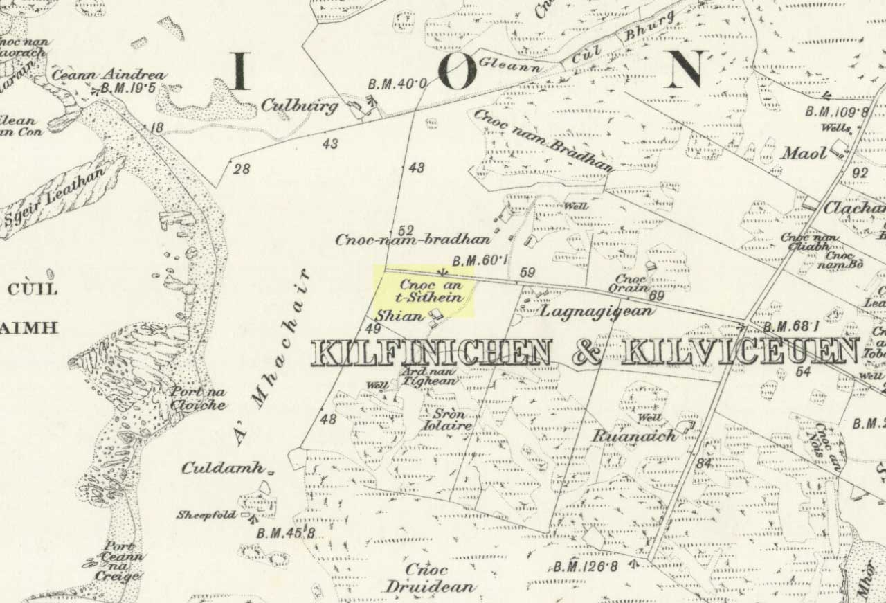
Site of the Sithean Mor on the 1881 OS-map
The day of the “feast of St. Michael” that Pennant mentioned was our indigenous heathen New Year, or Halloween, now usurped and misrepresented by countless plastic pagans and christians alike. It would appear from Pennant’s description that the circle in question was more likely a cairn circle. The fact that the heathen islanders celebrated annual rites here at Samhain, strongly implies there was once a hero-myth and a creation myth in evidence, but I am unaware of any remaining tales that may help confirm this. The coming of St. Columba may be responsible for this lack of oral tradition.
More than a century after Pennant’s visit here, the ring of stones had been destroyed. We know this from the description given by Archie MacMillan (1898) in his fine text on the antiquities of Iona, where he said,
“Angel Hill, called in the vernacular Sithean More. There was, not so very long ago, a circle of standing stones on the top of this hillock. They have been used for other purposes.”
Folklore
The most commonly recited tale of this grassy rise is that when St. Columba brought christianity to the island, he communed here with the angels. This is a simple displacement tale: of a new faith replacing an older one. The old name of the hill, Sithean Mor, tells that the littlepeople or fairy folk once held influence here.
References:
Cumming, C.F.G., In the Hebrides, Chatto & Windus: London 1883.
MacMillan, Archibald, Iona: Its History and Antiquities, Houlston & Sons: London 1898.
Pennant, Thomas, A Tour in Scotland, 1772 – Part 1, Benjamin White: London 1776.