From Balquhidder village, take the road east towards Auchtubh as if you’re gonna visit the Priest’s Stone, just past the house of Tom na Cruich on the right-hand side of the road. When you get to the house, if you ask the owners there how best to get to the stone, they are very friendly and very helpful in pointing you in the right direction.
Archaeology & History
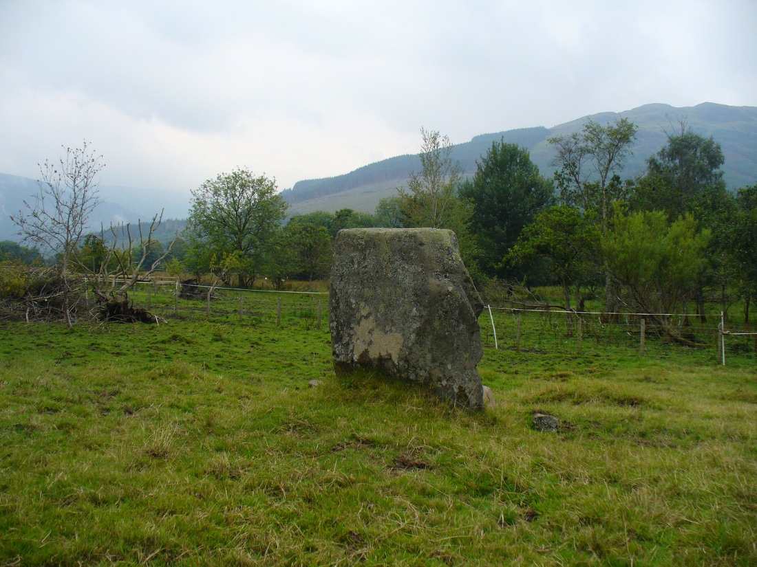
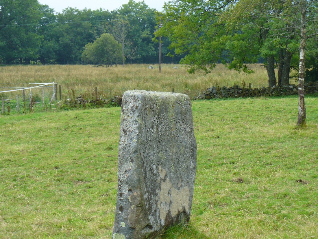
This solitary standing stone first seems to be mentioned in J.W. Gow’s (1887) essay on the prehistoric antiquities of this part of Rob Roy’s country. Found below the house and hillock where the old gallows used to be, he told:
“On the level ground below (Tom na Croich) …there is a prominent monolith, standing about 4½ feet above ground, quite flat, on the top. It is shaped like a wedge, with the edge to the east, and is famous in Balquhidder as the place where trials of strength took place.”
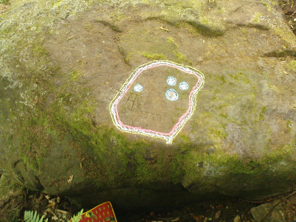
Note the stones in next fieldPuidrac Stone, looking N
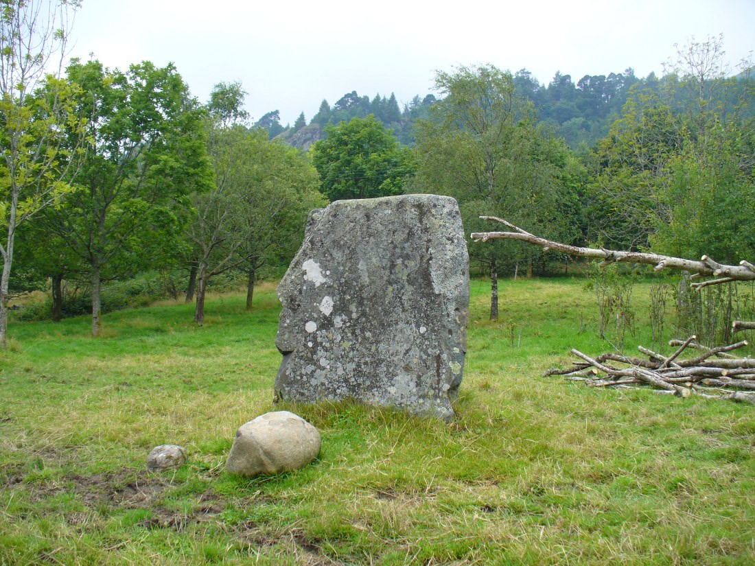
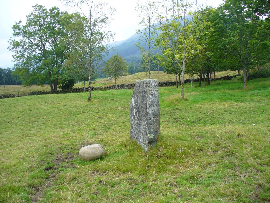
Below the standing stone is a small rock, whose predecessor played an important part in some local traditions relating to this site. (see ‘Folklore’ below) Also, due west of here in the next field, you will be able to see a couple of seemingly upright stones in the tall reeds 200 yards away, which early records say were part of a stone circle—now much in ruin—known as Clachan Aoraidh or the Worshipping Stones. There is the possibility that this single stone was an outlier to the circle. It’s astronomy might be worth checking….
Folklore
When we visited the stone last week, the owners of the house above asked if we’d managed “to lift the stone”—and I wondered what they meant at first, until they told us the folklore about the site. They narrated the tale almost exactly as it had been described first of all in J.W. Gow’s (1887) essay, which said the following:
A new ‘lifting stone’ in front of Puidrac
“It is shaped like a wedge, with the edge to the east, and is famous in Balquhidder as the place where trials of strength took place. A large round water-worn boulder, named after the district, ‘Puderag’, and weighing between two and three hundredweight, was the testing stone, which had to be lifted and placed on the top of the standing stone. There used to be a step about 18 inches from the top, on the east side of the stone, on which the lifting stone rested in its progress to the top. This step or ledge was broken off about thirty years ago, as told to me by the person who actually did it, and the breadth of the stone was thereby reduced about 8 inches. This particular mode of developing and testing the strength of the young men of the district has now fallen into disuse, and the lifting-stone game is a thing of the past. A former minister of the parish pronounced it a dangerous pastime. Many persons were permanently injured by their efforts to raise the stone, and it is said that he caused it to be thrown into the river, but others said it was built into the manse dyke, where it still remains. There were similar stones at Monachyle, at Strathyre, and at Callander, and no doubt in every district round about, but the man who could lift ‘Puderag’ was a strong man and a champion.”
The present stone that is positioned on the ground below the standing stone was put here in much more recent times.
References:
Gow, James M., “Notes in Balquhidder: Saint Angus, Curing Wells, Cup-Marked Stones, etc”, in Proceedings of the Society of Antiquaries Scotland, volume 21, 1887.
Acknowledgements: To Kenny and Laura for their help and guidance here. Huge thanks!
From Balquhidder village, take the road east towards Auchtubh as if you’re heading to the Clach nan Sul or Wester Auchleskine cup-marked stones. Before reaching either of these sites, a few hundred yards on the road as you pass Tom na Cruich on the right-side of the road, you need to look in the next field past this house. About 40 yards past here in the field, and less than 10 yards from the wall, you can see the large rock from the roadside. If not, you’re damn close! Ask the owners of the adjacent house, who are very friendly and helpful.
Archaeology & History
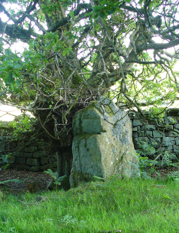
This curious, large, man-made cup-marking or bowl was first described in J.M. Gow’s (1887) essay on Balquhidder antiquities. He wrote:
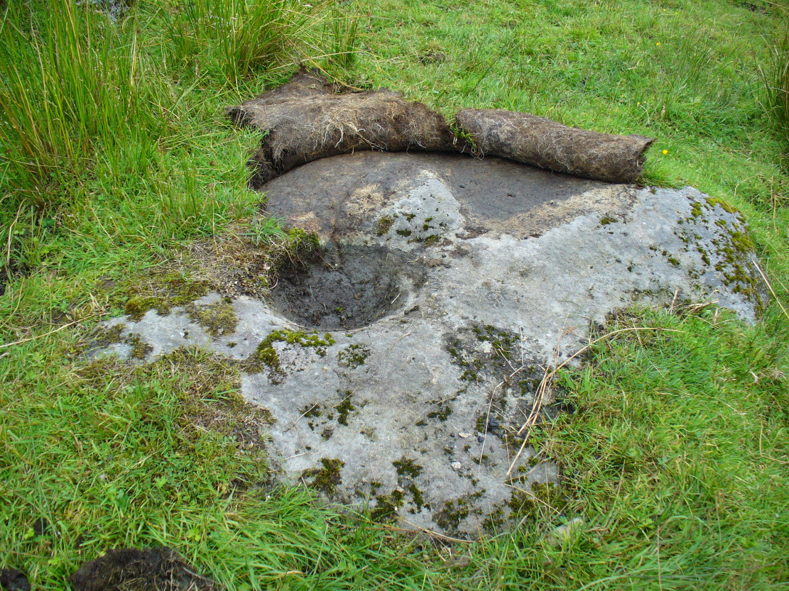
“Regaining the high road, and still going east, about 40 yards from the cottage of Mr Macdiarmid, there lies just inside the road dyke a large five-sided stone, about 8 feet long by 5 feet broad at the broadest part, and about 2 feet above ground. It is called “Basan an Sagairt” (the Priest’s Basin). When the present road and dyke were made, its name must have saved it. The hollow or basin is 18 inches in diameter and 6 inches deep, and is unmistakably artificial. The stone is the mica slate of the district, hard and granitic.”
Looking down on the basin
The large bowl here was also deemed to be artificial by members of Ordnance Survey and Royal Commission archaeologists who have inspected the site. It is thought to have been a healing stone of some sort, or at least possessed some religious function, but we have no records stating this with any certainty. In examples similar to this, the water which collects in the carved bowl is deemed to have curative properties. It may have been a christian attempt to take locals away from magickal healing stone practices enacted at the Clach nan Sul, or Stone of the Eyes, just a couple of hundred yards along the road east of here. Or it may have being a stone used by indigenous medicine men for other medicinal purposes.
Carved stone in one of the fields across the road
On the other side of the road from here, in the field immediately past Wester Auchleskine farm, as you go through the gate just ahead of you is a rounded earthfast stone with a similar man-made circular impression like the Priest’s Basin carved upon it. (NN 5451 2089) However, this carving doesn’t appear to have been finished. Whether it has any mythic relationship to the Priest’s stone or the cupmarked rocks at Wester Auchleskine in the same field, is not known.
References:
Gow, James M., “Notes in Balquhidder: Saint Angus, Curing Wells, Cup-Marked Stones, etc”, in Proceedings of the Society of Antiquaries Scotland, volume 21, 1887.
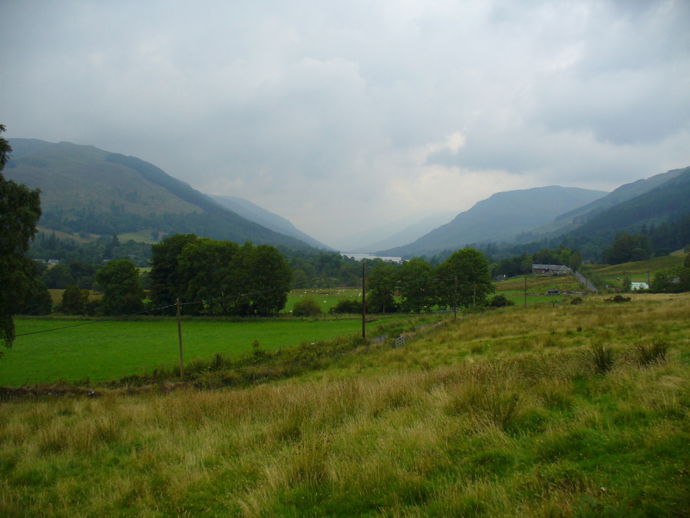
Looking down Balquhidder Glen from Clach nan Sul’s old home
Apparently destroyed, although some remains of the stone were said to be seen in the walling by the roadside; but when visiting this spot a few days ago the summer vegetation had completely covered any potential finds here. The stone fell foul of the usual self-righteous industrialists when the track alongside which it had sat for countless centuries was turned into a road and the stone was “blasted”. It was found some 20 yards below the large cup-marked stone known as Wester Auchleskine, seen amidst the clump of rocks in the field above.
The stone was described in MacKinlay’s (1893) fine survey on Scottish holy wells due to the healing properties of the waters that collected into the rock basin here. The earliest record of the site that I’ve found comes from the hallowed papers of the Scottish Society of Antiquaries, where—in J.M. Gow’s (1887) rambles just east of Balquidder—he told us the following:
“Going still further east to the first turning of the road beyond the farmhouse of Wester Auchleskine, and on the left-hand side, there used to be a large boulder with a natural cavity in its side, famous as a curing well for sore eyes. This stone was called “Clach nan sul” (the Stone of the Eyes). In 1878 the road trustees caused it to be blasted, as it was supposed to be a danger in the dark to passing vehicles. Its fragments were broken up, and used as road metal.”
Whether or not the site known as the Priest’s Basin, or Basan an Sagairt—a couple of hundred yards west by the roadside—was of a similar nature, or an attempt by christians to draw people away from the old healing Clach nan Sul and use this other one instead, we do not know. There are numerous accounts of other stones in this mountainous region of Scotland where rocks-with-hollows filled with water were attributed with healing properties, like the Whooping Cough Stone at Struan, the Measles Stone at Fearnan, and many others.
Folklore
The folklore described by Mr Gow was reiterated in MacKinlay’s (1893) survey. He also told how,
“The hollow in the Clach-nan-Sul at Balquhidder…contained small coins placed there by those who sought a cure for their sore eyes. Mr J. Macintosh Gow was told by some one in the district that ‘people, when going to church, having forgotten their small change, used in passing to put their hands in the well and find a coin.’ Mr Gow’s informant mentioned that he had done so himself.”
References:
Gow, James M., “Notes in Balquhidder: Saint Angus, Curing Wells, Cup-Marked Stones, etc”, in Proceedings of the Society of Antiquaries Scotland, volume 21, 1887.
MacKinlay, James M., Folklore of Scottish Lochs and Springs, William Hodge: Glasgow 1893.
Follow the directions to reach Panorama Woods carving 232. Barely a yard or two southwest across the small gap where the kids have their little den or hideout, this long curvaceous rock is the fella in question.
Archaeology & History
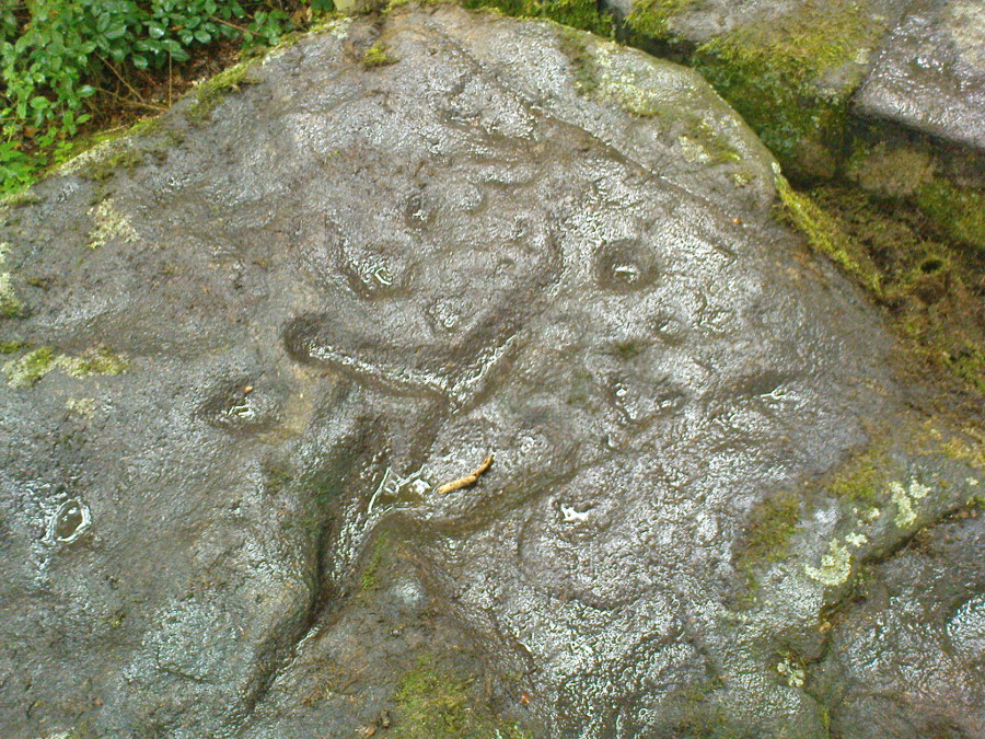
Cup-markings on the rock
Curiously not included in the ‘official’ records, this large piece of rock, living right in between the Panorama Woods carvings 231 and 232, has at least two, possibly three faint cup-marks etched in the top northeastern portion of the rock. Of the same style and probably period as the basic designs on stones 230 and 231, this is one in a cluster of petroglyphs that used to live at the edge of a prehistoric enclosure, destroyed at the end of the 19th century.
References:
Bennett, Paul, Of Cups and Rings and Things, unpublished: Shipley 1981.
Bennett, Paul, The Panorama Stones, Ilkley, TNA: Yorkshire 2012.
Take the Wells Road from Ilkley centre up towards White Wells, bending to the right as you hit the edge of the moor. Keep along the road, past the old college building with its lake and turn right up Westwood Drive. Keep going all the way up till you hit the small woodland on your right. Where the woodland ends – stop! Walk into the trees about 10-15 yards and you’ll see the large rocks ahead of you. Amongst other petroglyphs hereby, you’ll find this carving is on one of them.
Archaeology & History
Close-up of deep cups & grooves
Although only given the usual dry description by our academic catalogue chaps, there’s something about this design that I’ve always liked. We first came across it ourselves in the late 1970s, in search of the legendary Panorama Stones, and found instead this large enclosure design with at least three cups inside it, still clearly visible. It is one of a cluster of carvings hereby, all of which were once adjacent to a prehistoric enclosure, described in the 1880s and destroyed soon after. This and the associated carvings very probably had some archaeocentric relevance to the lost enclosure.
Large carved ‘enclosure’, recently chalkedDrawing of the carving (after Hedges 1986)
The carving is sandwiched in between its petroglyphic companions, stone 231 and stone 233. As can be seen on some of the photos here, more recent vandalism has been inflicted on this carving and the recent chalk colouring is what local archaeologists Gavin Edwards and Alex Gibson have termed “social history”, implying fallaciously that cup-and-ring art could be seen as little more than neolithic and Bronze Age scribblings on rock, without any meaning other than it being comparable to “Leeds United Rules OK.” They may be right (highly unlikely) – but in reading copiously about prehistoric petroglyphs in cultures beyond the UK, we find that traditional societies tell such carvings relate to their creation myths, or river spirits, or rock spirits, and are intrinsically related to wider animistic cosmologies and social customs. This indicates, to me at least, that modern archaeologists who think of rock art as little more than childish scribblings still have a great deal to learn and we should beware their uneducated musings about our ancient carvings.
Although the complete carved ‘enclosure’ and its internal cups were mistakenly drawn in John Hedges (1986) survey, he described as being a,
“Roughly incised ‘enclosure’ with five cups in it, twenty eight shallow cups or depressions, one large oval marking, three irregular basins.”
In the later work of rock art students Boughey & Vickerman’s (2003), they simply said of the site:
“Large flat-topped, upstanding rectangular rock. Twenty-eight shallow cups, a few enclosed in two groups by grooves; irregular small basins.”
References:
Bennett, Paul, Of Cups and Rings and Things, unpublished: Shipley 1981.
Bennett, Paul, The Panorama Stones, Ilkley, TNA: Yorkshire 2012.
Boughey, Keith & Vickerman, E.A., Prehistoric Rock Art of the West Riding, WYAS: Wakefield 2003.
Hedges, John (ed.), The Carved Rocks on Rombalds Moor, WYMCC: Wakefield 1986.
Take the same directions as if you’re visiting the multiple-ringed Agra Woods petroglyph (West Agra 8). From just below here, keep to the woodland side, and follow the line of tall drystone walling along to the east for a hundred yards or more, keeping your eyes peeled for the stone in question, just in front of a nice oak tree. You can’t really miss it!
Archaeology & History
Not too far away from the scattered cluster of West Agra’s cup-and-ring stones, can be found this very bulky six foot tall standing stone, near the edge of the old walling on the inner-side of the Agra Woods. It was rediscovered by Paul Hornby on a Northern Antiquarian outing in May 2011, who told it to be “quite a massive thing!” (I’ve yet to visit the site so can’t give my personal impressions of the site)
Get to Pubil at the top of Glen Lyon, then walk on the track on the north side of Loch Lyon. Several miles along you turn up Glen Meurain. When you reach the crossing of the stream, follow the waters up Allt Meurain for about 3-400 yards until you find a small flat section of marshland right by the streamside. You’ll notice rocky undulations of human remains here, and a distinct small cairn of rocks near the top of this section. Have a good rest here (and I’d advise avoiding the place in the summer months).
Archaeology & History
Remote indeed is this small cairn—less than 3 feet high and 4 feet across—sitting by the burn-side in a place many miles from any human habitation. It is found amidst a small cluster of other archaeological remains close to each other, as if indicating a settlement of sorts, abandoned probably around the time of the Highland Clearances. Although it is highlighted on modern OS-maps in antiquated lettering, the cairn here looks like it is only a few centuries old. A larger mass of rubble stone is found adjacent to the small pile of rocks, from which it may originally have been taken. Without archaeological analysis we will not know for certain the real age of this old tomb.
MacRee’s Cairn & adjacent rubble
Folklore
The small grassy hillside immediately across the trout stream here is known as Sith Trom’aidh – the Sad Fairy mound, whose history appears to have been lost. Alexander Stewart (1928) told that this cairn was the burial place of one of Colin Campbell’s dairymaids, found and slain here during a skirmish with cattle raiders in the 16th century.
References:
Stewart, Alexander, A Highland Parish; or, The History of Fortingall, Alex MacLaren & Sons: Glasgow 1928.
A very well-preserved prehistoric cist and cairn (grave), sat amidst a valuable prehistoric landscape full of megaliths and other important prehistoric remains. Megalith enthusiast and antiquarian, Nik Megalithic, told that:
“The cairn is about 12 m diameter and 1 metre high, and has a large Kist in the middle. The cist has side slabs about 2 metres long and spaced 1 metre apart, and it is about 0.7m deep. The large capstone is tipped off to the west, and can be seen protruding above the cairn from quite some distance away.”
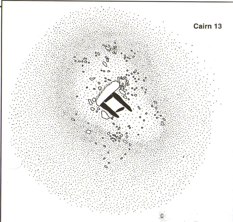
Described in association with the rich mass of other tombs and megalithic stone rows here, author Jeremy Butler told that,
“Cairn 13 is also in line with (cairns) 1-4, but just out of sight around the hillside 150m to the northwest. The mound contains a well-preserved cist, “a very fine example”, according to Worth, who cleared it out about 1900 but with “no result from excavation.” The displaced cover and massive side-slabs project well beyond its ends.”
Both Butler and Worth mention how cairn 13 is part of an alignment with two other cairns very close by.
Folklore
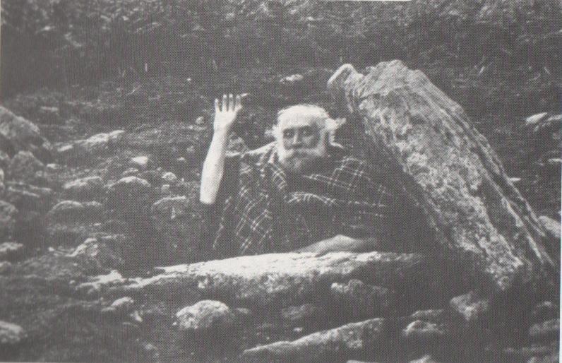
Spike Milligan in his tomb
Although legends of giants and pixy folk are well known round here, there is nothing specific I can find to this one site. One of the most important finds in recent years—as the photo above shows quite clearly—was the fact that before joining The Goons, the British comedian Spike Milligan used to live in this prehistoric tomb. When asked why he didn’t live in a house like other normal people, he invited us in for a cup of tea. Some historians believe that the person in the photo is in fact Mr R.H. Worth—author of Worth’s Dartmoor—but Mr Milligan insisted that Worth was an imposter!
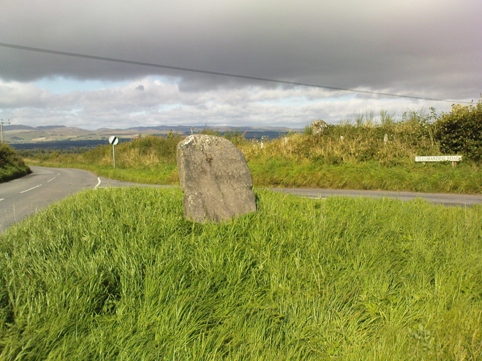
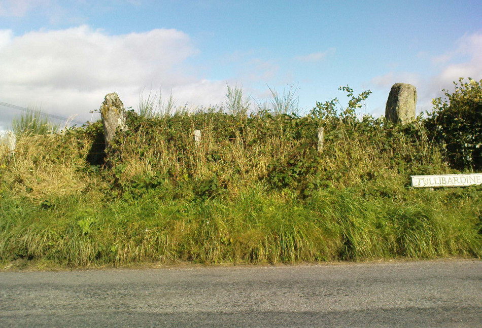
From Auchterarder’s A824 main street, going out towards the golf course take the Orchil Road on your right and then about fifty yards along, turn right again up Tullibardine Road. Park up somewhere about a hundred yards along, then just walk further down the road until you’ll see the standing stone right at the road junction. Look into the field on your right, above you, and another two are hiding in the brambles and grasses.
Archaeology & History
Included in Andy Finlayson’s (2010) fine local survey, this is an intriguing little group of three standing stones (and a fourth buried beneath the turf), all very close to each other. They are shown on the modern Ordnance Survey maps as “standing stones”, but have been catalogued by archaeologists as the denuded remains of a ‘Four Poster’ stone circle. Despite this, the circle wasn’t included in Aubrey Burl’s (1988) definitive work on the subject, nor his megalithic magnum opus. (Burl 2000)
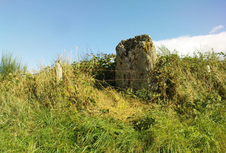
Northern hedgerow stone…and two in the hedgerow
Of the two uprights above the roadside at the field edge, a faint carved hand can be found on the upright west-facing side of the southernmost of the two standing stones. Although faint, this doesn’t appear to be ancient. Written accounts of these stones are few and far between it seems. The earliest seems to be in the lengthy essay written by Mr Hutchison (1893), in which he gave an excellent account:
“Less than a mile to the west of (Auchterarder)…is a fine group of stones, two only of which are now standing. These stand on the summit of what has been a well-defined mound, and the stones now lying where the roads unite seem to have stood originally at the same height. The road has been driven through the group at a lower level than the summit of the mound, and the stones have been thrown down and laid in the waste space at the point of junction. The small mercy to be thankful for is that they have not been broken up altogether and used for road metaL This has probably been due to the circumstances that one of these stones has a curious encircling groove running round it, which perhaps impressed even the vandal roadmakers with the idea that it might be worthy of preservation. It would be interesting to know whether, when the circle or group of stones was cut through, any cist or interment was found. One would expect such to be the case, but I have not yet got any information on the point. There are several stones lying on the spot which may or may not be pieces of the original standing stones. Two considerable bits of old red sandstone, at least, look as if they were fragments of an original whole. Two great stones, however, are unmistakably prostrate standing-stones; and from the positions in which they lie, it seems to me as if the persons who had uprooted them had laid them down as nearly as possible on the sites they had occupied (at the original higher level, of course) when standing.
“The direction in which both of the standing stones point is 236º, and a line taken from each of the prostrate stones to the opposite standing one gives very nearly the same angle (240º). The prostrate stones are of metamorphic schist. The northerly one measures 7 feet in length by 3 feet in width, and is from 12 to 18 inches thick. A grove or furrow, 2 inches deep at its greatest depth, and from 2 to 4 inches wide, appears to run right round it, at a distance of 2 feet 10 inches from the end, which may have been about the middle height of the stone when erect. The lower side of the stone cannot be seen, but the appearance at the edges indicates that the furrow is carried all the way round. It looks just such a hollow as might be worn in stone by the long continued attrition of an iron chain. The more southerly prostrate stone is 6 feet in length, 4 feet wide, and has an average thickness of 18 inches. The two stones still standing are on the high bank above the road, just inside the hedge. These are both of old red sandstone, thinnish slabs, facing in the direction already mentioned. That to the south is 4 feet 10 inches in height, 2 feet 8 inch broad at the base, and 10 inches thick. The other is 5 ft. 3 in. at its greatest height, 3 feet 10 inches wide, and from 13 to 15 indies thick. On its northern face it shows a number of depressions or indentations curiously resembling prints of human feet. These Mr Kidston considers to be due to natural weathering.”
Southern carved stone
Yet the “prints of human feet” are very much man-made. A closer examination of these carvings is obviously needed.
Whether these stones originally played a part in an old tumulus, a cairn circle, or a typical stone circle, is hard to say with any certainty now. We are in a landscape where megalithic remains were once in great excess: with the standing stones of Blackford to the south; the lost circle of Gleneagles nearby; the megaliths near Muthill and many many more…
References:
Burl, Aubrey, Four Posters: Bronze Age Stone Circles of Western Europe, BAR 195: Oxford 1988.
Finlayson, Andrew, The Stones of Strathearn, One Tree Island: Comrie 2010.
Hutchison, A.F., “The Standing Stones of Stirling District,” in The Stirling Antiquary, volume 1, 1893.
Strachan, Favid (ed.), A History of Blackford, Blackford Historical Society 2010.
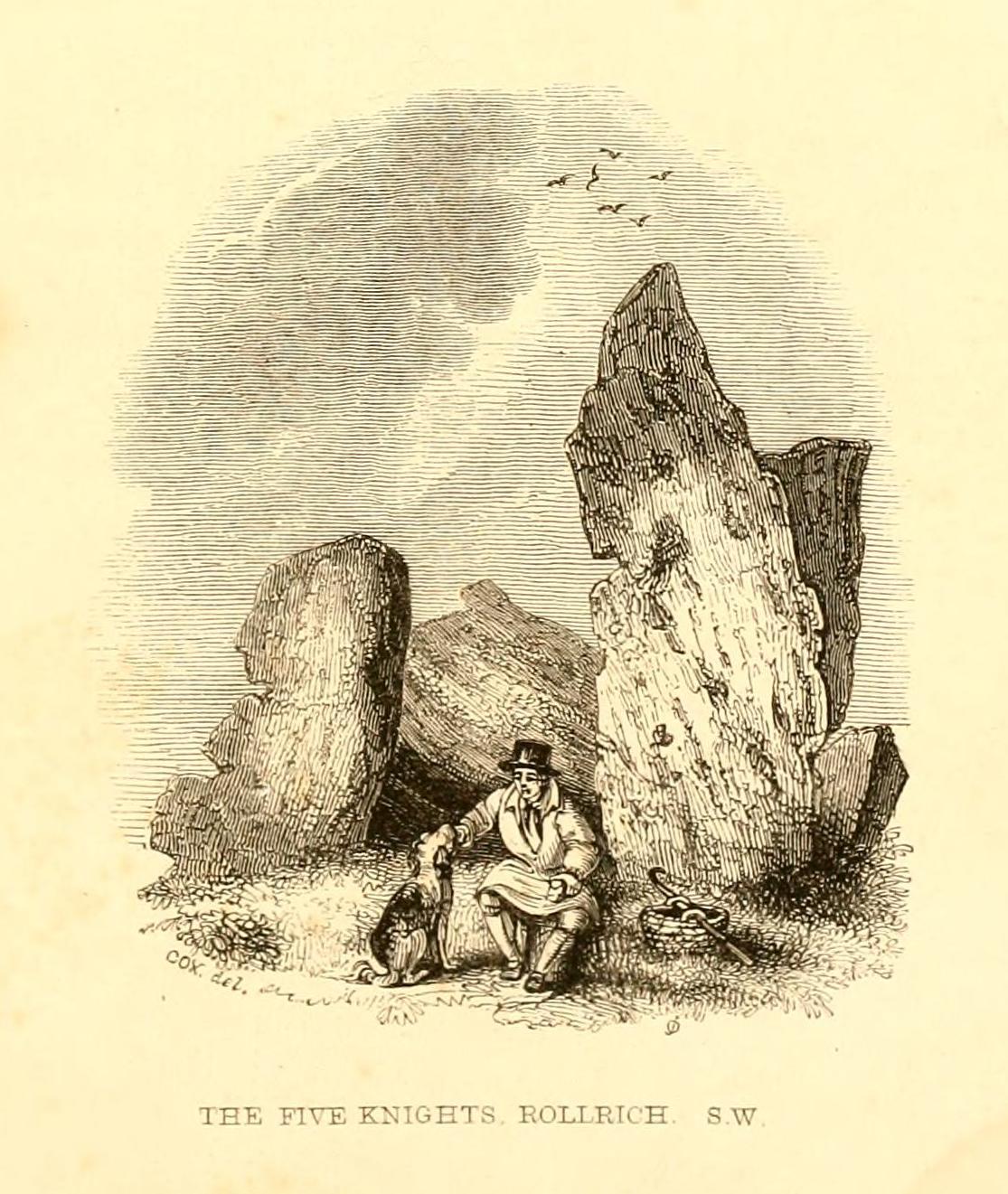
Follow the directions to reach the Rollrights stone circle, from Chipping Norton. Walk past the entrance to the circle along the road for a coupla hundred yards, keeping your eyes peeled looking into the field on your right. You’ll notice the large rocky mass of these Knights a hundred yards down in the field, which can be reached by a footpath running straight along the old hedge from the roadside straight to the collapsed tomb.
Archaeology & History
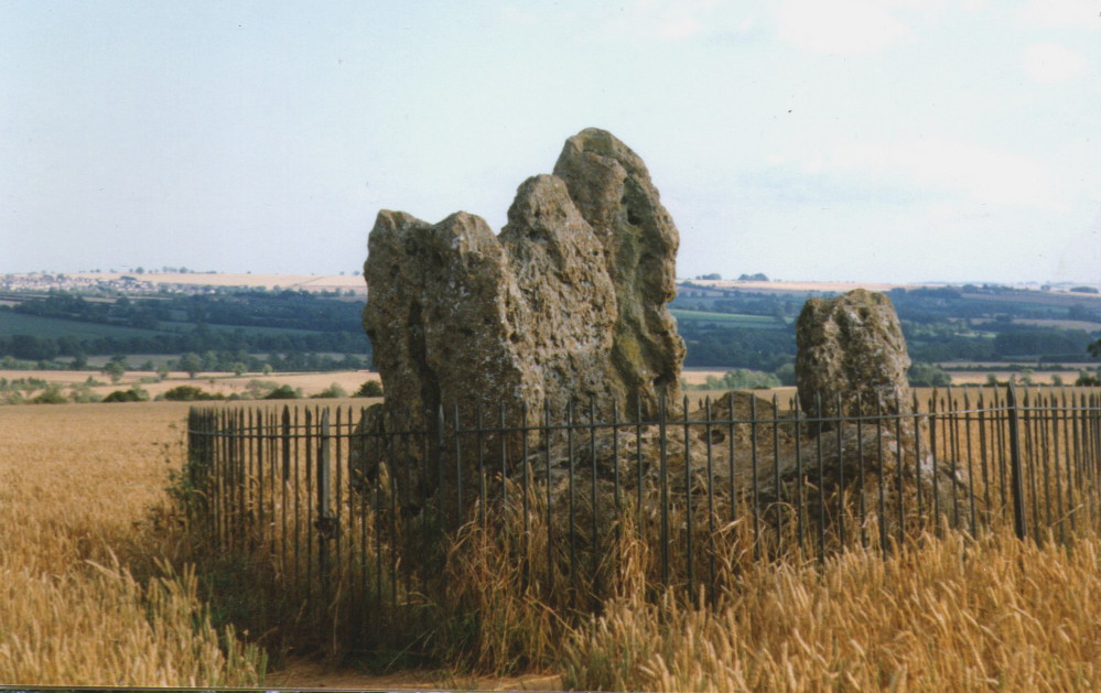
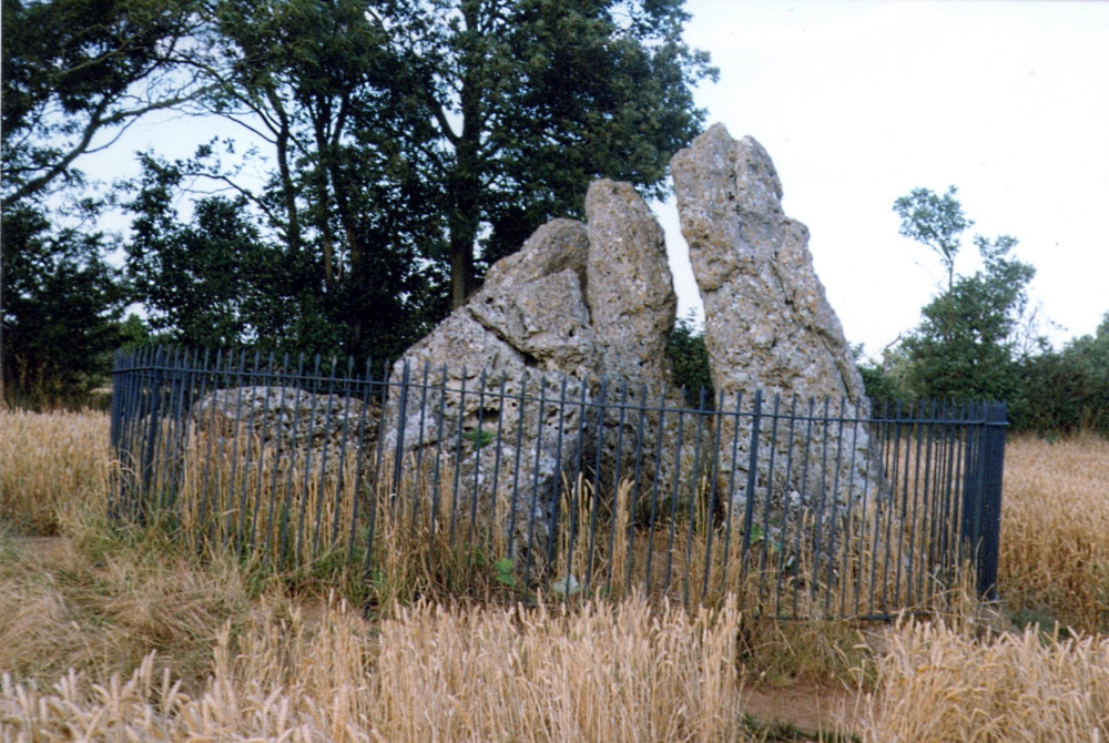
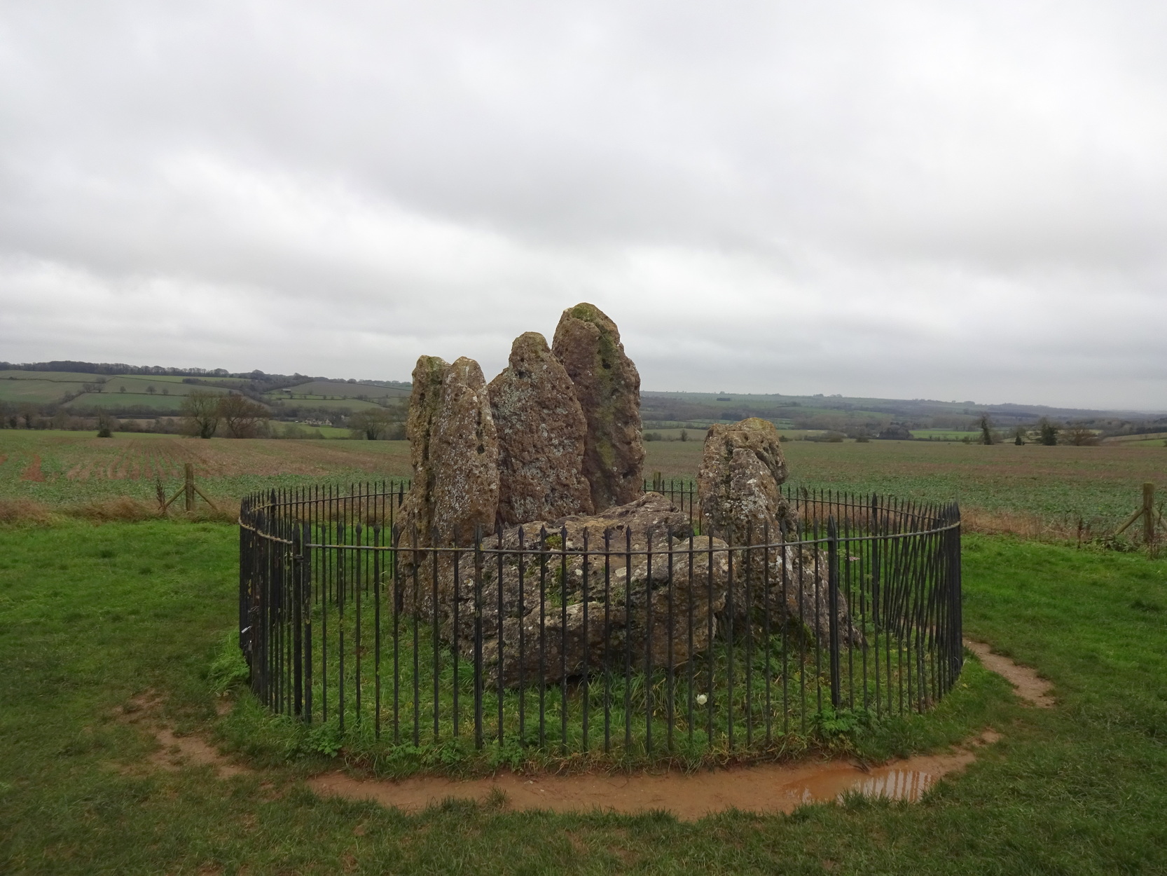
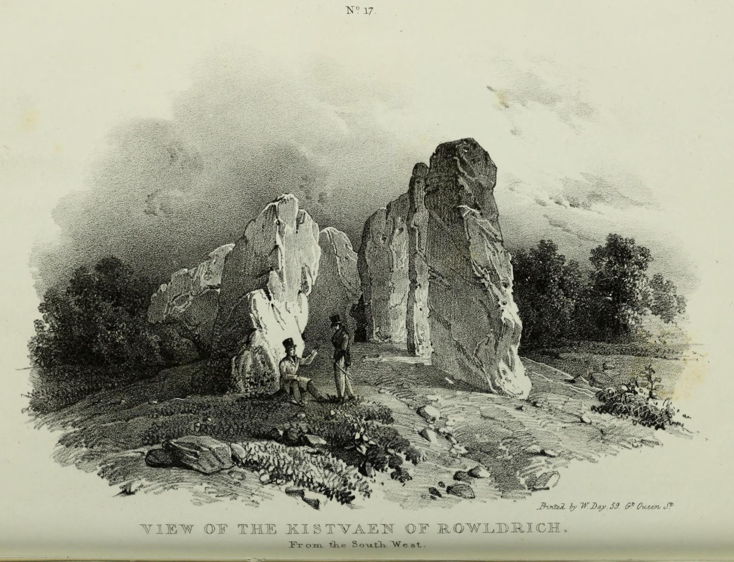
The Whispering Knights
A brilliant site—albeit nowhere like how it once was—where I slept a few times when I lived in the old hut at the Rollright stone circle down the road. A field-mouse lived here when I slept at the place and, hopefully, its ancestors still reside hereby (Rollright Trust’s poisons notwithstanding!). On my first encounter with the little fella, I felt him running into my waist-side whilst laying, dozing in the old tomb. He nudged into me—then again —and yet again; before I leaned over to see what was going on! And the little mouse looked up at me, without a care in the world, as if to say, “What are you doing lying on my path!? Can I get past please?” (though I’d not had a bath for a good 3 months, so didn’t smell like any modern human, which I think explained his total lack of fear)
Laying there, I smiled at the little fella, who then decided to jump up the side of my waist and walk over the top of me to get to the other side! He jumped down into the grasses and disappeared! However, a few minutes later, I felt another tiny ‘thud’ at my side and looked down to see the same lovely mouse wanting to go back along his obviously traditional route – and looking up at me again, whiskers twitching inquisitively, realised I was still here; and so once again took it upon himself to climb over the scruffy smelly human-sort who was blocking his route!
He was a gorgeous little mouse and we got to know each other quite well over the unwashed springs and summers I slept here….. But anyway, that’s not what you folks are interested in hearing about! Back to the archaeo-shit….
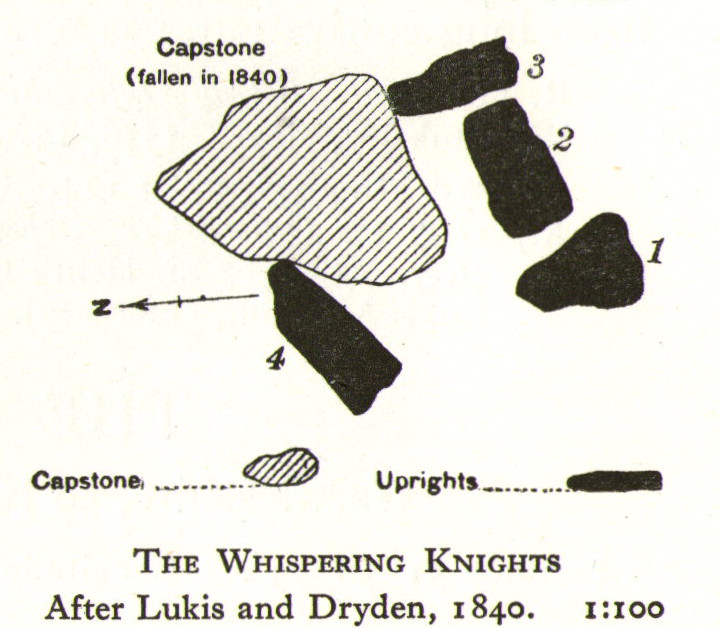
The Whispering Knights is one of the main sites in the cluster known collectively as the Rollright Stones, which also comprises of the standing stone commonly called the King Stone, plus the King’s Men stone circle a coupla hundred yards down the road from the Knights. They all sit atop of the ridge which separates the counties of Oxfordshire and Warwickshire along the edge of the prehistoric road known as the Jurassic Way. The sites are non-contemporaneous having been erected over a period of many centuries. The Whispering- or Five Knights are by far the oldest part of the complex dating from a period never previously anticipated. They comprise of four upright megaliths in close proximity, and a fifth fallen stone which is said to be the capstone on the original monument. This stone alone weighs some 10 tons.
The general archaeological opinion is that the place is a ‘portal dolmen burial chamber’ of which the capstone has fallen. The Oxford archaeologist George Lambrick (1988) postulated the stones to have been covered with a mound of earth, but any evidence supporting this has long since gone.
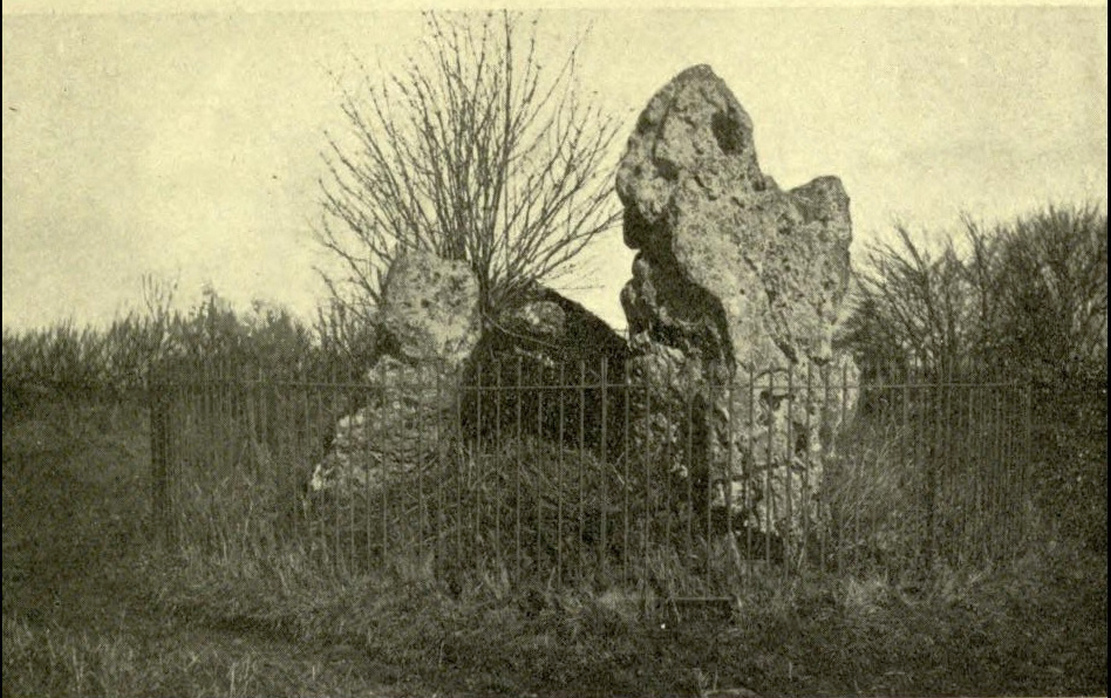
1920s postcard of the siteThe Knights in 1995
This great monument was initially thought by archaeologists to have been built sometime around 1800 BCE—a favourite date of academics for many an unexcavated site for many decades—until they turned their astute attention to the place in the 1980s. And what they found was astonishing. Well…astonishing for the archaeologists! Affirming the local folk tradition that the Knights were the “oldest monuments in Oxfordshire,” the dates truly went back. Way back! Datable remains at the site gave results from between 3500 and 3800 BCE: two thousand years earlier than anyone had ever expected of them.
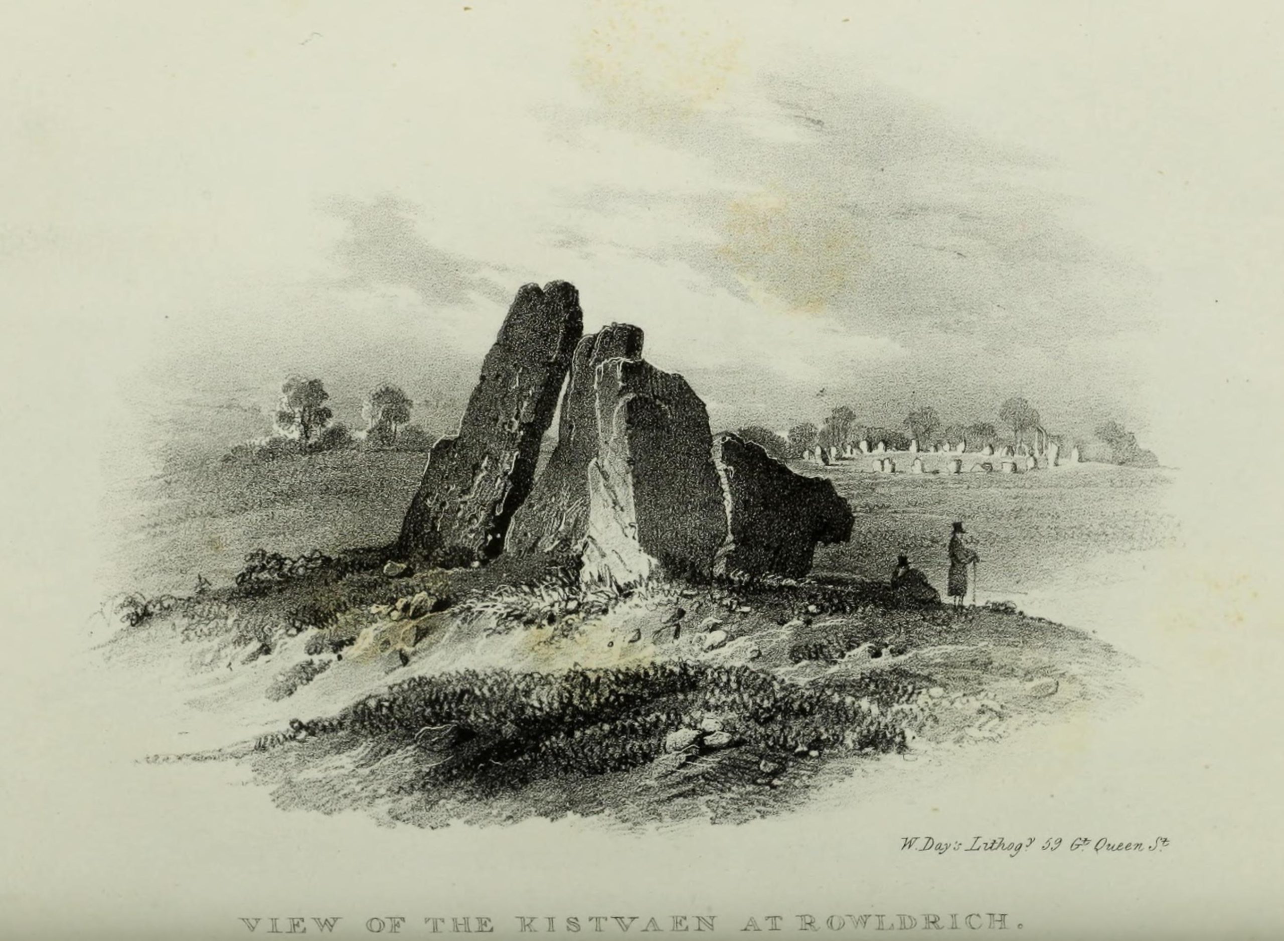
Although five stones remain of the site, when the great William Stukeley (1743) visited the Whispering Knights, he described six of them to be visible with the great stones here to be sat upon a tumulus, saying:
“Tis composed of six stones, one broader for the back part, two and two narrower for the sides, set square to the former; and above all, as a cover, a still larger. The opening is full west to the temple or Rowldrich. It stands on a round tumulus, and has a fine prospect southwestward down the valley, where the head of the Evenlode runs.”
O.G.S. Crawford (1932) told us of a description which Sir Henry Dryden gave of the Knights in 1898, when he wrote:
“About 356 yards E from the (Rollright) circle and S of the road, is the dolmen about to be described, called the Five Whispering Knights. It is in a ruinous state. It now consists of four stones, upright, or nearly so, and one prostrate, all of coarse limestone…
Height, 8ft 3ins (4ft by 2ft 6ins)
” , 7ft 3ins (3ft 6ins by 1ft 10ins)
” , 6ft 7ins (3ft 8ins by 1ft 4ins)
” , 5ft 4ins (4ft 9ins by 2ft)
Capstone (then fallen), 8ft 4ins by 5ft 9ins, by 2ft 4ins
“The chamber appears to have been about 5 feet 6 inches W and E, and the same N and S. If, as usual, there was an entrance, with or without a passage, it was probably to the ENE… There is not, so far as I know, any record of remains having been found in this dolmen. In a small stone pit about 700 feet NE by E from the circle it is stated that 12 skulls were found in 1835. In another stone pit near it was found in 1836 an urn and beads…”
1840 plan by Lukis & Dryden
During the last century, very little has really changed at the Knights. The ring fencing surrounding the stones has kept it pretty much protected, despite it ruining all sense of healthy ambience. But they have gained greater and greater attention the older they have got. Archaeologists are not the only ones exploring the site. Fascinated astronomers, engineers and architects have been and seemingly uncovered other mythic ingredients here.
Whispering Knights, 2016
When the legendary Alexander Thom came here, he used the archaeological data that was being espoused at the time, which said the Knights and the Rollright stones had both been built around 1750 to 1800 BC. With these dates as his guide, he found that someone standing at the centre of the Rollright circle, on the morning of the equinoxes—March 21 and September 21—the sun would rise right above the Whispering Knights. And the effect, he thought, was a notable one: with the light from the rising sun going straight through a hole in one of the stones in the circle as it rose up behind the Knights. It would have looked both spectacular and eerie in the rising mists of first light, like a laser cutting through the still morning air… However, although Thom’s measurements were very accurate, the archaeologists had got their dates wrong. Very wrong! For the Whispering Knights were about 1500 years older than the stone circle—and so the alignments Thom pronounced, based on the archaeologist’s erroneous proclamations, were also incorrect.
There may be other alignments connected to the Rollright complex. In a survey of the site as part of the Dragon Project experiments conducted here in June 1980, Leslie Banks and Christopher Stanley flew over the place and found, adjacent to the Whispering Knights, a quite distinct “trace of two dark green parallel lines in a field of ripening corn” running northwest to the roadside. To this day nobody quite understands the nature of this enigmatic alignment:
“In the absence of excavation we can only speculate,” said Stanley. “But the most likely explanation is that it is what archaeologists refer to as a Cursus. Cursuses are thought to be prehistoric religious processional ways.”
As with many of the alignments described here, the jury is still out on this one!
Folklore
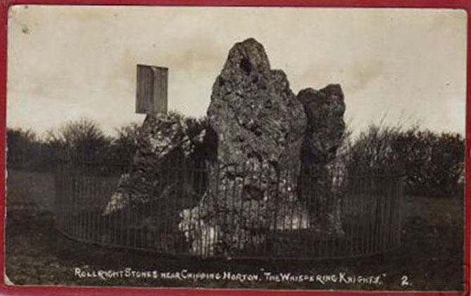
Whispering Knights, 1829
The folklore here is prodigious! The prime story of the neolithic tomb of the Whispering Knights tells that originally they were in fact a group of traitors who moved away from a King and his army in ages past, and who were plotting against him, when the great Witch of Rollright (a southern version of the great cailleach, found in more northern counties, Scotland and Ireland) turned them all to stone (this tale is intimately bound up with the King’s Men stone circle and the associated King Stone).
Whispering Knights, 1841
Another tale tells how the King Stone and the Whispering Knights venture, at midnight, less than half a mile south to drink from a spring in the small woodland at Little Rollright Spinney, although it is difficult to ascertain precisely which of the two springs the stones are supposed to visit. In some accounts, the stones reputedly drink from the well every night, but others tell that they only go there at certain times of the year, or on saint’s days. When Arthur Evans (1895) wrote of these tales he described there being a “gap in the bushes… through which they go down to the water,” but the terrain has altered since his day.
Other accounts imbuing the stones with life tell how they only ‘awaken’ when disturbed by humans. A story well-known to local people is that of when the Knights had its capstone removed one day by a farmer who used it to build a bridge across the stream at Little Rollright. As Evans told us,
“it took a score of horses to drag it down the hill, for at first it would not move, and they had to strain and strain to get it along till every bit of the harness was broken. At last they got it to the brook by Rollright Farm, and with great difficulty laid it across to serve as a bridge. But every night the stone turned over back again and was found in the morning lying on the grass.”
Three nights of this led the farmer to think he should replace the stone which, so the fable goes, took only one horse to move it back uphill and into position. A variation of the same tale was told by T.H. Ravenhill, who wrote:
“The Lord of the Manor of Little Rollright desired to possess the King’s Stone in order to bridge Little Rollright brook. So he dug it up and tried to cart it away, but found that he had not enough horses. He hitched on more, and yet more, and still he found that he could not move the stone. Finally he succeeded and hauled the stone away to the Manor House. The same night he was alarmed by strange sounds about the house, which he attributed to the presence of the King’s Stone, and decided, therefore, to replace it on its mound. No sooner had he harnessed the first horse to the cart than it galloped away up hill with ease, taking with it the stone, which leapt to position on reaching its resting place.”
There are still more variations that are worth mentioning. One from 1876,
“said that a miller in Long Compton, thinking the stone would be useful in damming the water of his mill, carried it away and used it for that purpose, but he found that whatever water was dammed up in the day disappeared in the night, and thinking it was done by the witches (at Long Compton) and that they would punish him for his impertinence in removing the stone, he took it back again; and, though it required three horses to take it to Long Compton, one easily brought it back.”
In yet another version, the stone was wanted by a local farmer for his outhouse. In taking it downhill, the horses that pulled his wagon died and the vehicle itself was irreparably damaged. It got even worse for the poor chap: his crops failed, his family were taken ill and his cattle died. Eventually when all but his last horse remained, he made another cart and it pulled the stone back uphill with ease. Thereafter, so the tale goes, all his adversities stopped and he lived a normal life. In one version of this tale, the great monolith was said to have been taken north-north-west down to the stream at The Hollows, Long Compton. Tales such as these are, once more, found throughout the world.
The truth of these stories was seemingly unquestionable to some local people in the 19th century,
“one man going as far as to say that there were those now living who had spoken to men who had helped to bring the stone down and up again.”
In William Stukeley’s day, one Farmer Baker was so troubled by his actions that he couldn’t rest until he returned the old stone.
The doyen of the early geodelic sciences or Earth Mysteries movement, John Michell, suggested how the legends of megaliths moving of their own accord harked back to ancient days when the people of those times were more attuned to the terrestrial magnetic flows of the Earth.
The Whispering Knights were also a place where “young girls of the neighbourhood (use it as) a kind of primitive oracle.” One local told Arthur Evans that around barley harvest the young women of the district visited the Five Knights to listen to them whisper. One at a time they would rest their ears against the strange shapes of stone and, if fortune and conditions were right, they would hear the future told. This mass of animistic lore is very revealing indeed, telling us much about the way our peasant ancestors viewed the living world around them. (Eliade 1958)
In more recent times, the site has been explored by dowsers and ley hunters, who claim to have found a veritable bags of fascinating lost material around the Knights. Although originally ‘leys’ were described by Alfred Watkins as quite acceptable prehistoric trackways linking site to site to site, in recent years the original theory has been ignored and superceded with a host of almost incredulous fluctuations. Leys these days can run just about anywhere – and do!
One writer who tells about the leys around Whispering Knights is Lawrence Main. (1997) He dowsed and found a ley running south to the famous White Horse at Uffington. Roy Cooper (1979) was the first person to write about this alignment and extended it further north to the impressive and legendary Brailles Hill. That one seems reasonable. However,
“Other leys I dowsed,” said Main, “Linked the King Stone, the stone circle, and the Whispering Knights with each other; the King Stone with Banbury Cross; the Whispering Knights with Hook Norton church; and the stone circle with the churches at Todenham and Stretton-on-Fosse.”
Another dowsing ley hunter is Dennis Wheatley (not The Devil Rides Out dood). He wrote a couple of short works on his lengthy experiments at the Rollright stones and reported how he found a
“tangential aerial energy course…across the country (which) latches on to a solitary standing stone, six miles south, known as the Hawk Stone.”
Perhaps of greater importance here is that Wheatley also discovered how,
“all of the Rollright ring’s stones engage in aerial energetic cross-talk with the King Stone producing a triangulation of energy lines.”
This cross-talk of Wheatley’s involves more than seventy energy lines running between the circle and the King’s Stone. He tells us that a greater “aerial cross-talk” also occurs between the circle and the Knights; and “a lesser energetic triangulation” runs between the King and the Knights.
Along similar lines are the findings of the dowser Reginald Smith. (1980) Beneath the Whispering Knights he claimed to have found,
“a concealed spring which runs underground to the northwest and may betoken a consecrated site; but 100 feet to the east there seems to be another blind spring with issue to the northeast.”
References:
Bennett, Paul & Wilson, Tom, The Old Stones of Rollright and District, Cockley Press: London 1999.
Burl, Aubrey, Great Stone Circles, Yale University Press: New York & London 1999.
Cooper, Roy, ‘Some Oxfordshire Leys,’ in The Ley Hunter 86, 1979.
Crawford, O.G.S., Long Barrows of the Cotswolds, John Bellows: Oxford 1932.
Devereux, Paul, Places of Power, Blandford: London 1990.
Devereux, Paul, The Sacred Place, Cassell: London 2000.
Eliade, Mircea, Patterns in Comparative Religion, Sheed & Ward: London 1958.
Evans, Arthur J., ‘The Rollright Stones and their Folklore (3 parts),’ in Folklore Journal, 1895.
Gelling, Margaret, The Place-Names of Oxfordshire – volume 2, Cambridge University Press 1971.
Graves, Tom, Dowsing: Techniques and Applications, Turnstone: London 1976.
Grinsell, Leslie V., The Ancient Burial Mounds of England, Methuen: London 1936.
Lambrick, George, The Rollright Stones: The Archaeology and Folklore of the Stones and their Surroundings, Oxford Archaeology Review 1983. (Reprinted and updated in 1988.)
Main, Lawrence, Walks in Mysterious Oxfordshire, Sigma: Wilmslow 1997.
Ravenhill, T.H., The Rollright Stones and the Men Who Erected Them, Little Rollright 1926.
Robins, Don, Circles of Silence, Souvenir Press: London 1985.
Smith, Reginald A., ‘Archaeological Dowsing,’ in Graves, Tom (ed.), Dowsing and Archaeology (Turnstone: Wellingborough 1980).
Stanley, Christopher C., ‘A Rollright Processional Way?’ in The Ley Hunter 90, 1981.
Stuart, Sheila, Lifting the Latch, Oxford University Press 1987.