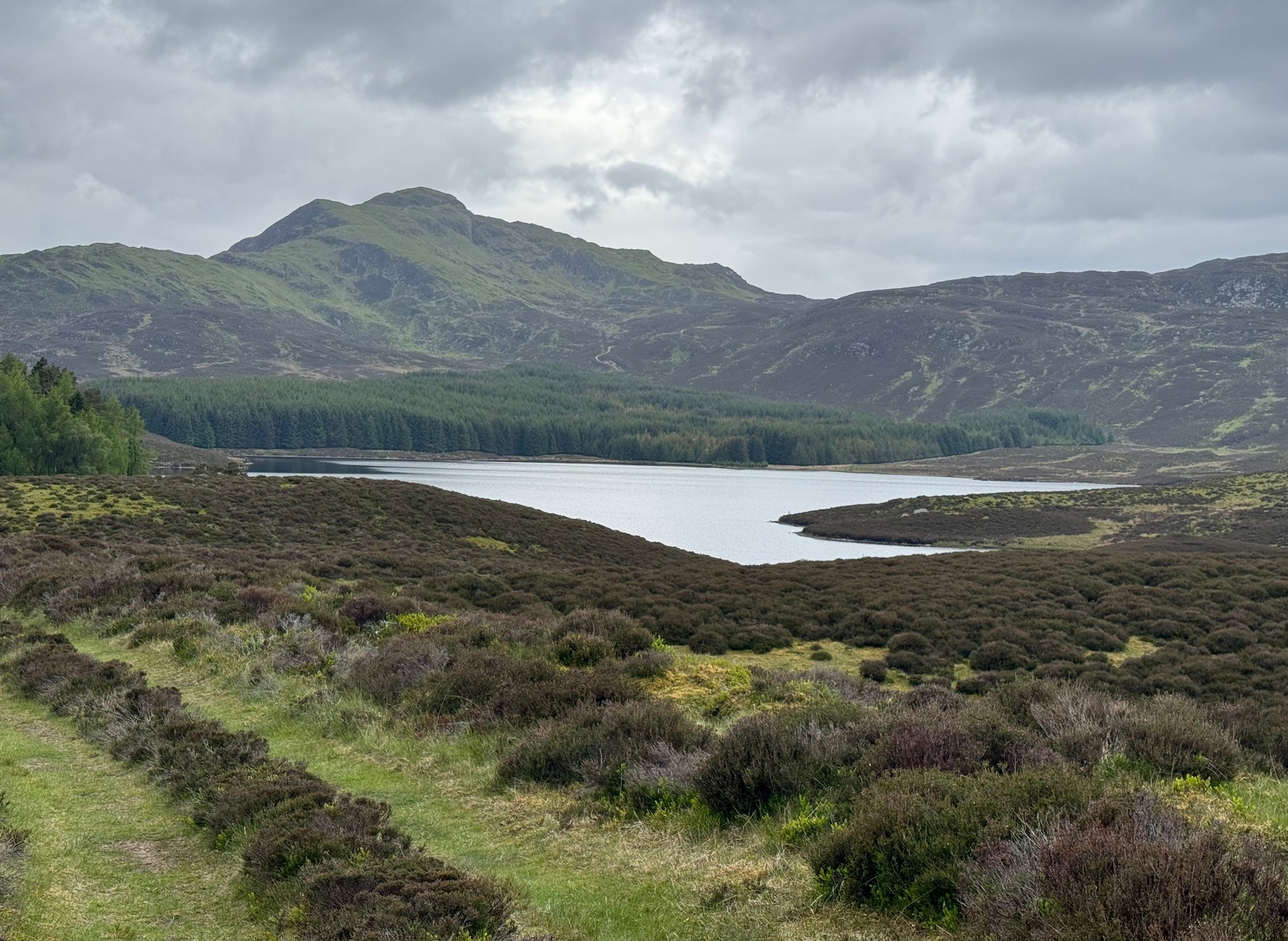
Although this upland loch is today renowned as little more than a decent fishing spot, the waters here were long known to be haunted and the abode of a legendary water spirit. In local tradition, the loch is said to be named after “an ancient Chief of Pictish origin” — whose burial mound is nearby — and in James Kennedy’s (1928) fascinating folklore work he also told that,
“Loch Dereculich was the habitation of a ‘Tarbh Uisge’ (water bull), the dangerous water demon… This dreaded monster, as the Norwegian peasant will gravely assure a traveller, demands every year a human victim, and carries off children who stray too near its abode… Less than one hundred and twenty years ago, the Loch Derculich Water Bull was seen sauntering along its shores. At peat-making times it was observed very frequently.”
References:
Kennedy, James, Folklore and Reminiscences of Strathtay and Grandtully, Munro Press: Perth 1928.
From the north side of Killin, take the minor road next to the Bridge of Lochay Hotel at Killin, past the hydroelectric station, through the wooded section until the fields open out again. The first gorgeous old house you come to is on the right-hand side of the road. Stop here! (I could really do with living here misself – tis a truly superb place!) You can ask the lady at the house where the carvings are and she’s very happy to point them out – they’re on the rocky crag near the bottom-end of the field on the other side of the road.
Archaeology & History
R.W.B. Morris sketch of the main carvings
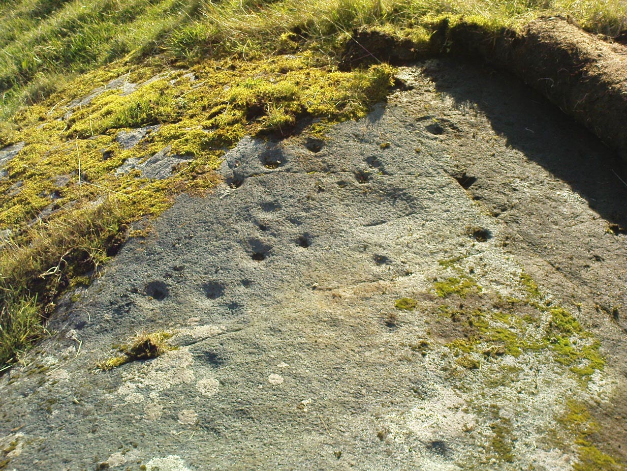
What a brilliant setting and clump of carvings we have here! As you get to the rocky hillock in the field, you see that there are numerous rocks visible along the ridge, a number of which have carvings on them – some with just cups, but most possess a number of cup-and-rings. It’s an excellent spot! Depending on the time of year when you come here will determine whether or not you get a better look at the carvings or not. I’d recommended April and May as the best time, as the vegetation is at its lowest then. Visiting the site near the end of summer doesn’t give you as good a view — but even then, if you like your rock art, you’ll still love it! The rocks here are mainly quartzite schist, with a number of the surfaces being almost pure quartz. Intriguingly, none of the pure quartz sections appear to have been carved on.
The carvings here were first mentioned in an article by D. Haggart (1895), who described them as “a very remarkable set of incised rock sculptures…discovered lately in this neighbourhood by Mr John McNaughton.” And remarkable they are indeed! In Ronald Morris’ (1981) survey of this site — which he labelled Duncroisk 1 — he counted eight separate rock surfaces that had been carved, marking them as carvings a-h, but there are at least eleven of them here; and in all honesty, if we could strip the surface of the hill of its vegetation, we’d probably find a few more hidden away!
Cup-marked stone
As you’ve walked across the field from the road, past the first unrecorded cup-marked stone near the start of the rocky rise, we reach Mr Morris’s ‘stone A’ near the easternmost end of the ridge, which is just a small slab of stone with “at least 6 cup-marks” on its surface. It’s easily missed in poor light, so watch out. However, if you reach ‘stone b’ (described below), just walk back ten steps and you’ll see it.
Carved Stone B
Ten yards west is ‘Stone B’, seemingly split into two sections, whereupon we find “a cup-and-two-rings and at least 12 cups-and-one-ring, up to 19cm in diameter – some rings gapped, others not, some with and some without a radial groove from the cup, and some with a “runner” or cup in a ring. There are also at least 58 cups” on this section of rock. ‘Stone C’ can also be missed, this time due to its size and the fact that the larger cup-marked surfaces are ahead of you. But assuming you don’t miss it, this carving consists of “a well-preserved cup-and-two-complete-rings 25cm in diameter, and a cup.”
Carved Stone D
‘Stone D’ is just next to ‘stone C’, but with rather more ornate designs etched upon it. This is one of the more archetypal petroglyph designs that are found in the photo-guides and textbooks. Morris (1981) told that it consisted “of a cup-and-two-complete-rings and 2 cups-and-one-complete-ring up to 20cm in diameter, also a cup-and-one-complete-ring and 2 cups.” The photo here shows it pretty clearly.
Carved Stone ECurious ‘bowl’, top-centre
‘Stone E’ is the next one along, just a foot or two away and Mr Morris (1981) told that the carving consists of “2 cups-and-one-ring up to 13cm in diameters, 1 complete, the others gapped, joined by groove to a cup, and at least 33 cups (C.G. Cash counted 42 in 1911).” Most of the carved elements on this rock are around the edges of the stone. A very large faded circular depression, man-made, is also visible on this section of the petroglyph (above left), suggestive of lunar symbolism.
Carved Stone F
‘Stone F’ is less than 10 yards further west and has the greatest number of cup-markings of the entire group here, as Morris described: “3 cups-and-one-complete-ring up to 9cm in diameter, and at least 80 cups, a few of which are widely scattered over a big area sloping steeply further south, beyond the attached diagram.” It’s perhaps the most notable of the carved rocks along the ridge here — not by virtue of its design, more its geological physique than anything else.
Carved stone G
‘Stone G’ is next along and has a curious look about it, suggestive of more modern times. At first sight it doesn’t seem to have quite the magnitude that Morris’ description affords it, but on closer inspection by rolling some of the covering turf back away from the rock, you can see what he meant. This stone has “10 cups-and-one-complete-ring, up to 10cm diameter…and also 15 cups.” One of the cup-and-rings on this section was found by Morris to have been “the smallest so far recorded by the author in Scotland.”
Then we reach ‘stone H’ at the eastern end of the carved ridge, consisting of simply 3 cup-markings. One of them has a faint arc pecked around it. Further along the rock, a complete cup-and-ring is visible close to the edge.
This entire line of petroglyphs is a fine place in a fine setting, perfect for meditative practices! Other carvings can be found close by: Duncroisk 3 is a coupla hundred yards east across the field just over the fence by the riverside; and Duncroisk 2 is on the other side of the fence down towards the River Lochay on the same side of the adjacent burn less than 100 yards away (though this is trickier to reach). Other prehistoric sites can be found not too far away…
Folklore
Local people tell of having seen curious lights flitting along the edges of the field, river Lochay and roadside close to the carved rocks hereby.
Go through Killin past the Bridge of Lochay pub, turning immediately down the small lane by its side. After about 3 miles you’ll cross over the small river past Duncroisk. Keep going for another few hundred yards (if you reach Tullich you’ve gone too far), watching out for the gate on your left. Walk up to the top of this field, over the wall and up again. You’ll see a couple of tall trees with distinctive walling next to them, just on a ridge above you. That’s where you’re heading!
Archaeology & History
This is a fine-looking example of a prehistoric enclosure, perched on the edge of one of the grassy knolls on the far western extremities of the deserted village of Tirai. If you walk towards it from the derelict village east of here, the elliptical form of the site gives you the distinct impression that you’ve just chanced upon a seemingly unknown stone circle nestled upon the edges of this gorgeous Scottish glen; but this initial excitement is soon dispelled once you get into the heart of the site!
Southern line of wallingLooking east
Although you’ll find a couple of derelict post-medieval buildings on the western side of this structure, the lay-out of this monument would seem to be Iron Age origin, perhaps earlier. It certainly has all the hallmarks of a walled structure from that period and typifies many others that I’ve explored down the years.
The eastern and southern sections of the walls are in very good states of preservation, although the ground has obviously grown up and around the bases of the stonework. It has a total outer circumferences of about 95 yards (87m), with the many upright stones measuring between 12 inches to more than 3 feet in height. The western section of the enclosure is mostly overgrown but easily traced on foot. Near the centre of the site is a large flattish stone that gave the impression of having an oratory function from where one could speak to the rest of the people sat around the inner edges of the enclosure — but this was a purely subjective impression.
NE sections of enclosureOuter section & ‘standing stone’
On the southern side of the elliptical structure is another, outer line of walling, or a stone alignment of some sort just a few yards long, consisting of just a few upright stones — one of which stands considerably taller than all the others hereby, giving the impression of a standing stone. It has a large natural cup-marking on its southern face.
To my limited knowledge there’s been no excavations here, so one wonders whether or how or if the people of Tirai made use of this much earlier building. The Canmore entry of the place tells:
“The N side of this enclosure is a low turf and stone bank of height 0.3m and is 20m long, spread to about 1.2m. The E side is outlined by large stones set on edge with no evidence of intermediate stone walling or turf. A bank of similar more continuous stone extends to the W from the S of the main enclosure down sloping ground. This type of walling is different from any other on Tirai. The large stones set on end have suggested a prehistoric date for this enclosure.”
References:
Johnstone, A. & Wood, S., “Tirai (Killin Parish), Pre-Enclosure Settlements,” in Discovery & Excavation in Scotland, 1990.
Although this great and legendary cathedral is today a christian centre, it seems that the site had been deemed as sacred by a much earlier, indigenous culture — though on a scale much more humbling than the grand edifice we see standing here today! For in the northwest corner of the church grounds in 1928, a small burial cist was located. Years later, on October 2, 1975, following work here by the North of Scotland Hydro-electric Board to uncover the main supply “in an area adjacent to the north wall of the Lady Chapel,” they found a slab of stone which, when they lifted it up, covered what appeared to be a burial cist. Messrs Gordon & Gourlay (1976) narrated:
“The stone slab which the workmen had removed proved to be the western section of a larger slab which at some period had been fractured and the eastern section lost. As the interior of the cist was filled with soil similar to that surrounding it and containing a considerable quantity of dispersed human bone fragments, it was suggested that the eastern section of the covering slab had been lost when the drainage and/or electricity services were being installed. The upper surface of the slabs western section was c.35cms below ground surface. The dispersed bones in the cist were at first considered intrusive — possibly from old burials when the public services were installed — and an undisturbed deposition of bones at the base of the cist seemed to confirm this. However, an examination of the bones by Dr A. Young…and Dr D. Lunt…showed that the deposit contained remains of two adults and one child and that many of the dispersed bones could be matched with those in the undisturbed group. In fact, the deposition suggested a re-use of the cist.
“The cist measured internally 1.20m by 0.44m by 0.28m. It lay 8.4m east of the door of the Lady Chapel and 1.44m from the wall of the same. The cist was constructed from ten irregularly-shaped sandstone slabs, with one fractured slab forming the floor. On the south side, two smaller slabs had been placed on the inside of the wall to support the covering slab which only just fitted the cist, and to give extra strength to the wall since they overlapped the vertical joins of the three slabs of the south wall. The north wall slanted to meet the west-end slab 12cm from its edge, giving the cist a coffin-like appearance. The north wall was still vertical; the narrowing was probably intentional as the covering slab was only 33cm wide at that point and the bones lay apparently undisturbed, parallel to the north and south walls. It proved impossible to examine the old ground surface because of the public installations, but it did appear that the ground sloped to the west as the cist certainly did.”
Although the remains found here were not dated, it was initially thought that the cist may have been made around the period when the Lady Chapel was erected around 1250 AD.
“However, Mr J. Stevenson of the Royal Commission for Ancient and Historical Monuments pointed out that the dimensions and construction of the cist accord well with cists of known prehistoric dates in the area; the cist (therefore) would seem to be placed early in the sequences of cist development, assuming it to be prehistoric.”
References:
Cockburn, James H., The Celtic Church in Dunblane, Society of Friends of Dunblane Cathedral: Dunblane 1954.
Gordon, Alistair R. & Gourlay, Robert B., “A Cist Burial, Dunblane Cathedral, Perthshire,” in Glasgow Archaeological Society Bulletin, No.2, 1976.
This large cup-marked stone was known by local people as the Clach na Sithean, or the stone of the fairies. Its smooth surface and well-cut grooves was said to be due to the fairies sharpening their knives upon it, and the straight cuts or grooves were tests of the keenness of their blades.
In addition to the fairies having hold over this stone, a brownie creature also roamed between here and the burn of Allt Mor. Although a dutiful creature, he commonly used to scare the women when they returned from the ceilidhs by chasing them and screaming a curious noise at them. But as well as this, he would also enter the local houses and farms after nightfall and, when the local folk were asleep, would clean the supper dishes and put them in their rightful places. But if there was no work to be done once he had entered their homes, he would take the dishes out and place them on the floors where they would be found in the morning by perplexed householders. Then they’d know that the brownie had visited. Sometimes he was a great help to the housewives, other times a nuisance. He became known to local people as Puddlefoot, or Cas an Lubain, but so offended was he by the name when he heard it, that he let out an almighty scream and vanished, never to be seen again.
References:
Kennedy, James, Folklore and Reminiscences of Strathtay and Grandtully, Munro Press: Perth 1927.
From Killin, take the Glen Lochay Road past the Moirlanich Longhouse, but keep on for another mile, and take the track on the left up to Murlaganmore cottages. As the track turns right of the tree-line, cross the field (left) up towards the open gate as if you’re going to the Murlaganmore 2 carving, where you’ll see this large flattish rock in the grasses about 100 yards before it.
Archaeology & History
When we visited this old boulder last week, we had the misfortune of grey days and dark clouds throwing their faded light across this cup-marked rock, not really letting us see with any clarity the many cups which pepper (mainly) the edges of the rock. But the cups are faded anyway, so accounts tell, and the 15 which we counted were same 15 recorded about 100 years ago in C.G. Cash’s (1912) survey. There, he described this old stone as,
“about 200 yards south of the house, in the middle of the uppermost pasture. It is a large block of quartz schist stuck thick with garnets, and bearing fifteen cup-marks, only one of which — 3 inch in diameter and 1 inch deep — is really well defined, and several of which are faint.”
Faint cups barely visibleC.G. Cash’s early drawing
But despite the grey day (She was absolutely teeming with rain half of the time!), I found the setting here absolutely gorgeous, with the many shades of old trees and the clear blood of pure waters falling through the landscape. And, without doubt, there are other carved stones nearby that have yet to capture the attention of surveyors. You can smell them!
References:
Cash, C.G., ‘Archaeological Gleanings from Killin,’ in PSAS 46, 1911-12.
Royal Commission on Ancient & Historical Monuments, Scotland, The Archaeological Sites and Monuments of Stirling District, RCAHMS: Edinburgh 1979.
Take the same direction to reach the Murlaganmore Footprint, continuing up past the cottages. 100 yards on, where there’s a bend in the track, cross the field on your left and go thru the gate higher up the slope. Stick to the small rough ‘path’, past the Murlaganmore 1 carving for nearly 100 yards, where a small rocking-stone-like rock is ahead of you. That’s it!
Archaeology & History
Close-up of cup-marks
This stone’s in a lovely setting, with the craggy rise of Creag Mhor and the waterfall of Airigh an Fhraoich up the rich coloured slope behind it. But the carving here is a simple one, with perhaps only 2 cup-markings etched on the stone’s upper surface, as the photo here shows. Tis a lovely setting though, and there are other carved rocks living nearby which aint yet seen the pages of any record-books.
It was first mentioned in C.G. Cash’s (1912) essay on the antiquities of Killin and district, who told that here was “one well-cut cup, 3 inches in diameter and 1½ inches deep, and also a doubtful or faint one.” The carving was later listed in the Royal Commission’s Stirling District report (1979) as simply “a boulder bearing cup-marks.”
References:
Cash, C.G., ‘Archaeological Gleanings from Killin,’ in PSAS 46, 1911-12.
Royal Commission on Ancient & Historical Monuments, Scotland, The Archaeological Sites and Monuments of Stirling District, RCAHMS: Edinburgh 1979.
From Killin, take the small road to the Moirlanich Longhouse, but keep on for another mile. Just before the road crosses the river, stop! In the fields above you to the left are a few trees and some rocks. Walk uphill till you’re nearly level with the cottages at Murlaganmore (the gate’s about 10-15 yards away) just above the gorze bushes and check out the long rock. If you can’t see it at first, bimble about till you find it. You’re just about on it!
Although shown on modern OS-maps as a ‘Sculptured Rock’ and included in the Canmore survey, when we visited this site a few days ago I have to say that unless evidence to the contrary can be obtained, this ‘site’ should be declassified as an archaeological remnant of the prehistoric period. It appears to be natural — though could have had some agricultural purpose or origin in centuries past.
The ‘footprint’ appears to have been described first of all by F.W.L. Thomas (1879) in his essay on the inaugural seat of Kings at Dunadd, where a similar footprint is found at the top of the fort. Thomas thought that this curious footprint could have had a similar function — though even folklore hereabouts seems silent on such a matter. The site is included in Ron Morris’ 1981 survey, where he too described it as “probably natural but just possibly man-improved.”
References:
Morris, Ronald W.B., The Prehistoric Rock Art of Southern Scotland, BAR: Oxford 1981.
Thomas, F.W.L., ‘Dunadd, Glassary, Argyllshire: The Place of Inauguration of the Dalriadic Kings’, in Proc Soc Antiq Scot, vol.13, 1879.
Truly troublesome if you aint into walking. Many ways up, but the easiest has to be the zigzagging trackway up from the valley bottom just by The Green a few hundred yards past Lochay Power Station, up the southern edge of Creag na Cailleach. At the end of the trackway, take the stream uphill for a few hundred yards and watch out for the rocky rise to your right (east). Head for it and check out the rocks there. You’ll find it!
Archaeology & History
Single cup-marked rock below Creag na Cailleach
I’m not sure that anything’s previously been written about this curious single cup-marked boulder. I say ‘curious’, simply because of the location and position of the clear cup-mark on this near-gigantic piece of embedded stone. We walked upon the rocky outcrop south of Creag na Cailleach (above the tree-line where the land levels out) and first saw the cup-marking at the top-end of this huge rock (amidst a number of others) on the large rise a coupla hundred yards west of Allt na Ceardaich. And as the carved cup was on the top-end of the boulder, I was expecting to find much more of the rock with other motifs scattering its body — but was amazed to find that this was the only single cup-marking on an otherwise huge stone. A mixture of bewilderment and disappointment came over me as I shook my head in disbelief that only a single cup had been scribed into an otherwise massive rock.
Close-up of the cup-marking
However, the light was poor with low cloud and it was nearing sunset, so there may have been other aspects to this carving which we missed out on. One other ‘possible’ cup-mark might have been done, but it seemed very dubious even in the poor light. I was all for having another look at it the following day; but wandering halfway up a mountain just to see if this was the only cup-marking on this outcrop was summat my daughter wasn’t into doing! So the site must await another mad cup-and-ring-crazed traveller on another day to get a more detailed inspection! George – are you out there anytime soon!?
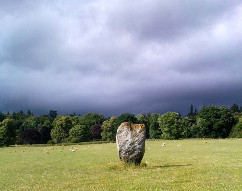
Going thru Pitlochry town, turn up the A924 road for about a mile till you hit the Moulin Inn on your left-hand side. Just past here, take the road left and continue for 2-300 yards until the stone in the field stands out on your right-hands side. Y’ can’t really miss it!
Archaeology & History
I should mebbe have this site entered as a ‘stone circle’ and not just an old monolith, as numerous other standing stones were in close attendant not too long ago and it was said to have been a circle. Certainly when the great Fred Coles (1908) talked about this place, he
“was informed by the tenant, Mr Reid…that many years ago, in his grandfather’s time, “there were several more stones standing”, all smaller than this monolith and that, upon the orders given by Mrs Grant Ferguson of Baledmund, some of these were saved from total demolition, and are supposed to be lying half-buried in the field to this day.”
…and here’s the big man close-up
Though I imagine these remnants have now been removed. Aerial images, when conditions are just right, might prove fruitful here.
But the solitary stone still standing here is quite a big fella. Heavily encrusted with quartz and more than 7 feet tall, it’s a nice fat chunky thing, with its lower half being somewhat slimmer than the top. Well worth having a look at!
Folklore
Once an old moot site, folklore also tells that an old market was once held here (there was some other folklore I had of this place, but can’t for the life of me find it at the moment!).
“Loch Dereculich was the habitation of a ‘Tarbh Uisge’ (water bull), the dangerous water demon… This dreaded monster, as the Norwegian peasant will gravely assure a traveller, demands every year a human victim, and carries off children who stray too near its abode… Less than one hundred and twenty years ago, the Loch Derculich Water Bull was seen sauntering along its shores. At peat-making times it was observed very frequently.”