Follow the same directions to reach the other Ellers Woods carvings, staying on the western-side of the river close to where it meets with Snowden Beck, just north of the footpath. Check it out in winter and early Spring — any later in the year and it might be a little overgrown.
Archaeology & History
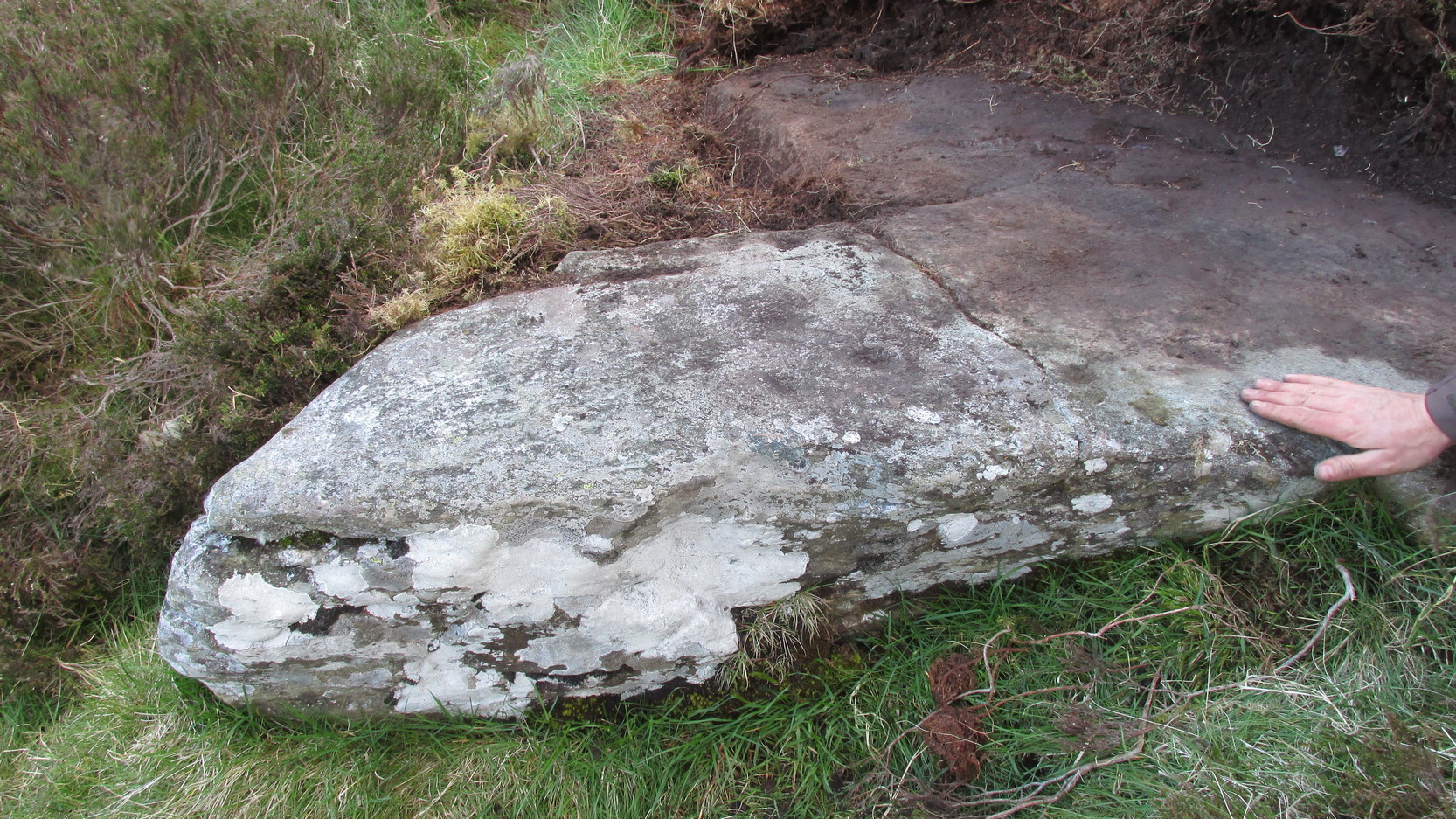
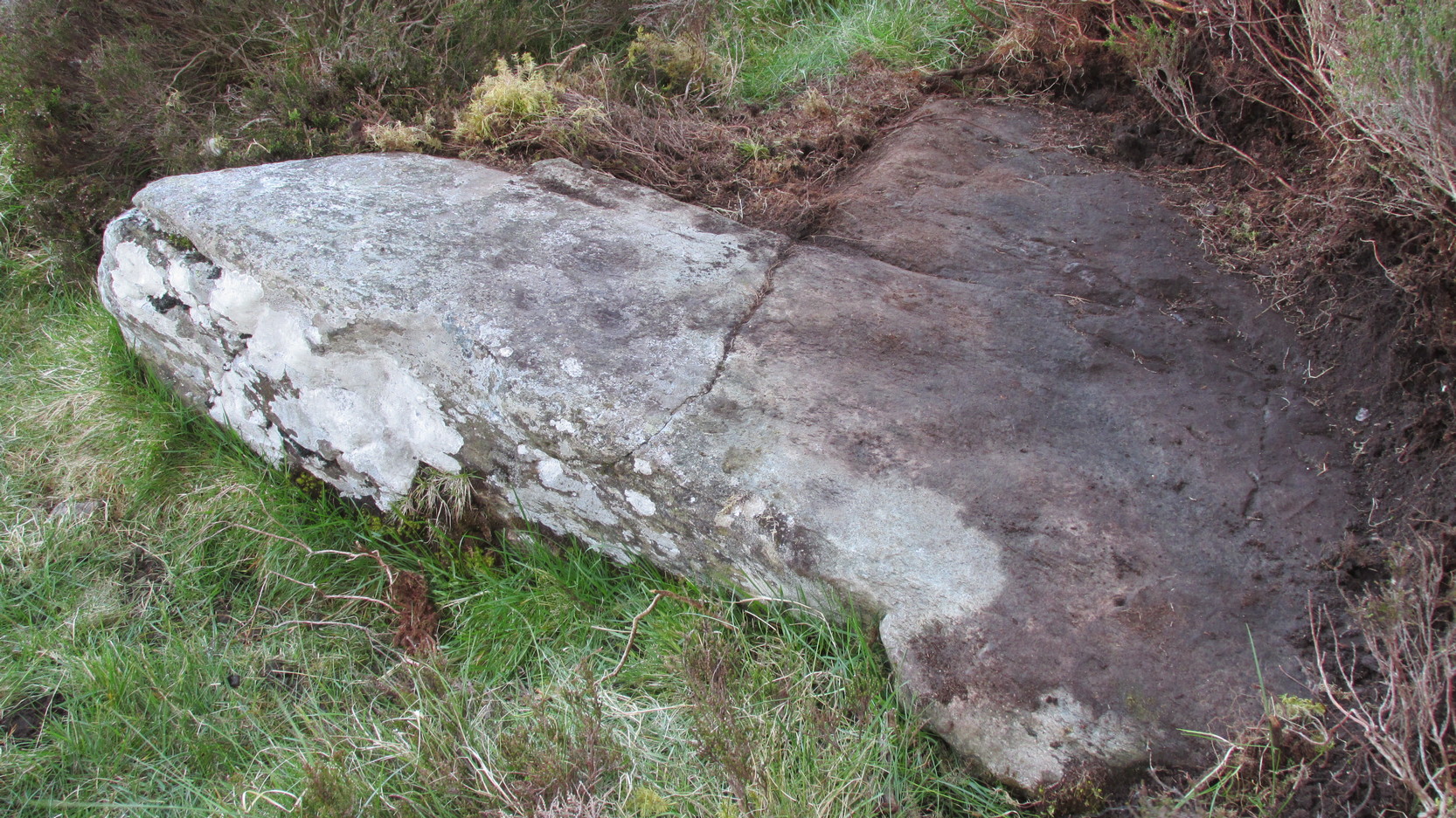
A truly lovely, lichen enriched carved rock in a lovely little part of the Fewston valley. The place has a distinct genius loci that’s very different from its carved rock companions on the moorland hills a short distance away. As I’ve said elsewhere: the surroundings of trees and richer fertile growth is something we must remember to ascribe to these carvings when we encounter them, as the landscape in places such as Ellers Wood is much closer to the scattered forested landscape that profused when first these stones were inscribed.
Section of CR-618
First described by Cowling & Hartley in 1937, it was later included in Cowling’s (1946) more extensive prehistoric survey of mid-Wharfedale. There may be as many as 38 cup-markings cut onto the rock here, along with several lines and grooves. A meditative dreaming site indeed…
References:
Boughey, K.J.S. & Vickerman, E.A., Prehistoric Rock Art of the West Riding, WYAS: Exeter 2003.
Cowling, E.T., ‘A Classification of West Yorkshire Cup and Ring Stones,’ in Yorks. Arch. Journal 1940.
Cowling, Eric T., Rombald’s Way, William Walker: Otley 1946.
Cowling, E.T. & Hartley, C.A., ‘Cup and Ring Markings to the North of Otley,’ in Yorks. Arch. Journal 33, 1937.
Grainge, William, The History and Topography of the Forest of Knareborough, J.R. Smith: London 1871.
Grainge, William, History and Topography of the Townships of Little Timble, Great Timble and the Hamlet of Snowden, William Walker: Otley 1895
Once to be seen on the highest point of the island, this impressive 9-foot tall standing stone is thought to have been removed during construction of the old lighthouse around 1833. First described by a traveller here in 1784, it was mentioned just once again during survey work in 1829. The monolith appears to have recorded the midwinter sunset.
References:
Royal Commission on the Ancient & Historical Monuments of Scotland, Argyll – volume 2: Lorn, HMSO: Edinburgh 1975.
Found a few miles south of Banbury and running in a southeast to northwest alignment, Paul Devereux wrote that,
“the crop marks of this cursus fragment were first photographed by James Pickering in 1972…between the villages of East Adderbury and Bodicote…close to the River Cherwell. The southeast end is square; the other terminus is unknown.”
References:
Pennick, Nigel, & Devereux, Paul, Lines on the Landscape, Hale: London 1989.
Go up the A93 road from Blairgowrie, after 5 miles turn right at the Bridge of Cally and up Glen Shee. After another 3½ miles, keep your eyes peeled for the iny road on the right signposted to the Drumturk Cheese farmshop. Go up this long tiny winding road, a mile up past the cheese place (which are gorgeous btw!) and onto the open moors. Keep on this road for another 2¼ miles where you can park up near the entrance to the huge wind-farm. Walk up the track to the windmills, bearing right at the first junction, then right again at the next one. From here, walk to the second windmill and from its base walk down, east, into the heather for about 80 yards. You’re damn close!
Archaeology & History
Drumderg (3) carving
On this T-square-shaped earthfast stone, a hundred-and-twenty yards north of the impressive Drumberg (2) petroglyph and just 10 yards below the remains of an impressive hut circle, we find this somewhat plain cup-marked design. It was covered pretty deeply beneath the heather when we came here and it took some time before we could see what we were looking at. The grey skies and poor daylight didn’t help matters either, as the cups were difficult to make out at first, but, thankfully, you can just about see them in the photos.
There are between five and seven shallow but distinct cup-markings on the flat surface, one of which may have a faint ring around it. In truth, this carving’s only gonna be for the real geeks amongst you.
An old stone-lined burial cist could once be seen in this locale: reported in 1953 to have been “discovered in the southwest corner of a field south of Druimyeonbeg farmhouse.” When it was uncovered by the farmer, the covering capstone was missing. Any relics that may have been there were destroyed and there’s now no trace of anything.
References:
Royal Commission on the Ancient & Historical Monuments of Scotland, Argyll – Volume 1: Kintyre, Glasgow 1971.
From the north-end of Loch Tay at Kenmore, follow the road (A827) round down the lochside, through the village of Fearnan and then another 4 miles down. If you park up at the pub at Lawers, walk back up the road for ½-mile, keeping your eyes peeled up the slope on the left where you’ll see the circle visible from the road.
Archaeology & History
Much has been said of this fine old place – also known as Lawer’s Mill – which seems to have been first described by Thomas Pennant in his rambling Tour in Scotland (1772). The local writer William A. Gillies (1938) told that after
“a recent examination of the ground around the circle…suggests that at one time there was an outer circle of stones concentric with the existing one. Most of the stones were removed in order to make more of the field available for cultivation, but there are still large stones buried within a few inches of the surface.”
Folklore
In J. McDiarmid’s Folklore of Breadalbane (1910) he tells of a man from Killin who, on passing by this old circle, heard haunting fairy music. Being inquisitive, he walked up to see what was going on and walked into the circle where the little people were playing. He was obviously lucky and the faerie-folk enjoyed his company, for when he left he was given the gift of a strong, fast, white steed.
Solar folklore may be…?
References:
Gillies, William A., In Famed Breadalbane, Munro Press: Perth 1938.
This minor cursus monument was etched into the landscape in neolithic times. Found to the south of Abingdon and close to the River Thames, one report showed finds from the site dating from 2900 BC. There is also a neolithic henge monument very close to its northern terminus and a plethora of other Bronze Age remains all round. Paul Devereux (1989) described how crop marks revealed,
“a substantial former cursus immediately to the east of Drayton: its crop marks extend southwest to northeast for a little over a mile, and are 225 feet (68 metres) wide. The cursus has a squared south end, but the northern terminus has not been found. The crop marks are not evident in the middle portion of the cursus, as it was formerly overlaid by a Saxon village. There is a plethora of other crop marks within and around the cursus… The northern section…which has a slightly different orientation to the southern segment, points squarely to the ancient heart of Abingdon.”
References:
Ainslie, R. & Wallis, J., ‘Excavations on the Cursus at Drayton, Oxon’, in Oxoniensis 52, 1987.
Barclay, A., Lambrick, G., Moore, J. & Robinson, M., Lines in the Landscape, OAU: Oxford 2003.
Loveday, Roy, Inscribed Across the Landscape, Tempus: Stroud 2006.
Pennick, Nigel & Devereux, Paul, Lines on the Landscape, Hale: London 1989.
Takes a bitta finding and aint too accessible for those of you who need footpaths! Below the eastern slopes of Addlebrough Hill, by the present source of the Gill Beck right beneath the Dove Stones (the water tastes gorgeous), are the ruinous remains of an old sheepfold. In the field immediately behind (south) of here are a number of small rocks. Look around and you’ll find the stone in question!
Archaeology & History
Unless you’re a real rock-art-freak, I can’t imagine too many of you checking this one out! When Richard Stroud and I visited this spot a few years back (2006), it was a mixture of love and madness that brought us here!
Dove Stones Carving
Amidst the many stones scattered hereabouts, one of them possesses two clear cup-marks on a stone measuring roughly 3ft by 2ft, along the line of a much ruined ancient wall. This might be the one that Beckensall and Laurie (1998) described in their Prehistoric Rock Art of County Durham, Swaledale and Wensleydale, as “a rock with several cups (which) has recently been noticed on Thornton Rust Moor, near the Dovestones” — though it seemed blatantly apparent to us that there were only two cups here, not “several”. However, Brown (2008) appears to list the site, citing it as having “two cups”, just like the one we found, and being “found in prehistoric low field settlement wall,” which fits the picture perfectly — although Brown gives a slight difference in grid-reference to the one Richard Stroud took. It looks a good area to scout around and, I reckon, find previously unrecorded sites.
References:
Beckensall, Stan & Laurie, T., The Prehistoric Rock Art of County Durham, Swaledale and Wensleydale, County Durham Books 1998.
Brown, Paul & Barbara, Prehistoric Rock Art in the Northern Dales, Tempus: Stroud 2008.
Nowadays marked on modern Ordnance Survey maps as part of a ‘Neolithic Sacred Complex,’ this linear monument was part and parcel of the Dorchester Big Rings henge complex and was associated with a number of other important prehistoric sites, many of which have been destroyed by ecological disfigurement projects in recent years. In Gordon Copley’s (1958) description of the monument, not long after its initial discovery, he said that this “was a cursus which consists of parallel ditches some 4000 feet long with 210 feet between them.” In more recent times Paul Devereux (1989) described how the cursus here,
“ran for three-quarters of a mile (1.2km) in a northwest to southeast direction on the north side of the Thames and was 210 feet (64 metres) wide. The cursus was part of a complex of crop marks, the most notable being” the henge. “The northwest end of the cursus remains unknown; the southeast end was rounded. The southeast segment…was on a slightly skew alignment compared to the rest of the feature, though it may have been the earliest part of the monument – bones found there were radio-carbon dated to around 3000 BC. The southern ditch of the cursus ran through and connected two earlier sites which shared a different alignment. Deposits of cremated bones, a stone arrowhead, fragments of pottery, a polished flint axe, and a circle of pits, probably the remains of a ‘woodhenge’ structure, were all found with the cursus.”
Dorchester cursus plan 1985
Jean Cook (1985) told that later excavations on the site in 1981, found that the shallow ditch which surrounded the entire cursus, “was interrupted by a central entrance on the southeast side. The southeastern terminal ditch respected a small prehistoric monument which has been dated to approximately 2000 BC.” This and other factors has led to the thought that the cursus may not all have been built at the same time. And indeed excavations at other sites scattering the northwestern ends of the cursus (shown in the plan here, Ed.) proved that a D-shaped enclosure “pre-dates the rest of the structure.” Other mortuary sites scattered the edges of the cursus that were added in the centuries which followed, but which need excavation work to uncover their secrets. Although much of this was done in the Atkinson digs, they were summarised well by Jean Cook (1985), who told:
“Site VIII, excavated in 1948, was a monument known as a mortuary enclosure. Sometimes such structures take the form of long barrows, but this one was a rectangular enclosure bounded on all four sides by a ditch with an internal bank. There were narrow entrance gaps on the two longer sides and a wider entrance in the centre of the shorter southern side. It is dated by the substantial sherds of Ebbsfleet ware (pottery) which were found in the upper filling of the ditch; part of a human jaw from within the enclosure helps to confirm the mortuary function.
“Site XI, excavated in 1949, consisted of three or more concentric ditches, of different dates, enclosing an incomplete ring of 14 pits. The middle ditch seems to have surrounded an oval barrow or enclosure and to have then been converted to a circular plan. Some of the pits contained animal bones, one contained an antler pick and one contained a complete human cremation, but there were no accompanying grave goods.
“Both these sites were in existence before the cursus was built. (my italics, Ed.) This is shown by the fact that the southernmost ditch of the cursus cuts through Site VIII and abuts Site XI. These two earlier sites seem to share the same alignment, but once the cursus was constructed it set a new alignment which may have been of significance until the end of the 3rd millenium BC. Three monuments built after the construction of the cursus were located inside it, two of them being along the central axis, and two others were just outside the southernmost ditch of the cursus but shared the same general alignment.
“Sites IV, V and VI, which were also excavated in 1949, have a similar overall plan and all of them contained a number of cremation deposits suggesting that amongst other things they acted as cemeteries. All three sites had a circular plan and consisted of an outer bank, to define the central area, and an inner ditch, the purpose of which seems to have been to provide earth for the bank. In Site IV the ditch was made up of eight oval pits, enclosing an area of about six metres in diameter. There was a broad entrance gap on the southeast side. Inside the enclosed area there were 25 deposits of cremated bones. An arrowhead was found with one of the cremations. Site V was very similar in construction, except that the entrance gap was on the northwestern side and contained 21 cremation deposits. No grave goods were found. Site VI again had a similar plan with the entrance gap to the north. There were 49 cremation deposits , one accompanied by a flint fabricator, an arrowhead and burnt flint flakes.
“Site 1 was excavated in 1946 and consisted of a small square ditch, enclosing another more or les circular ditch with an internal bank. Inside this ditch were 13 holes, forming a ring with an entrance gap on the western side. There were no entrances in the surrounding ditches. A crouched burial was found within the entrance to the ring of holes but there were no accompanying grave goods. Four cremations were found, two accompanied by fragmentary bone pins, in or besides four of the central holes. At a later stage in the neolithic period, parts of the ditch may have been enlarged to make temporary shelters: it is not clear to which period of use the cremations belong.
“Site II, also excavated in 1946, consisted of a causewayed (interrupted) ring ditch which was enlarged on two occasions. The third ditch had an internal bank in which were 19 cremation deposits. Two more cremations were found at the centre of the enclosed area. There was no evidence for any gap. Bone pins were found with four of the cremations as were flint fragments. In addition, antlers and other flint fragments were found, as well as pieces of pottery.
“In 1981 a small semi-circular enclosed ditch was excavated within the southeast terminal of the cursus. Though sited off-centre, the ditch shared the same alignment with the cursus. An antler (dated to c.2000 BC) was found close to the bottom of the ditch. After the ditch had virtually filled up with silt, the surviving low central mound was used for cremation deposits, one of them associated with a heavily burnt flint blade.”
Paul Devereux (1989) pointed out how one of the archaeologists studying this site found that if the axis of the monument was extended southeast, across the river, it lined up perfectly with another set of perfectly straight lines which were thought “likely to be a Roman trackway.” Unfortunately much of this area has been destroyed through the self-righteous ignorance of modern industrialism.
References:
Atkinson, R.J.C. et al, Excavations at Dorchester, Oxon, Department of Antiquities: Oxford 1951.
Barclay, A., Lambrick, G., Moore, J. & Robinson, M., Lines in the Landscape, OAU: Oxford 2003.
Cook, Jean, “The Earliest Evidence,” in Dorchester through the Ages, Oxford University 1985.
Cook, Jean & Rowley, Trevor (eds.), Dorchester through the Ages, Oxford University 1985.
Copley, Gordon J., An Archaeology of South-East England, Phoenix House: London 1958.
Loveday, Roy, Inscribed Across the Landscape, Tempus: Stroud 2006.
Pennick, Nigel & Devereux, Paul, Lines on the Landscape, Hale: London 1989.
Easy one this! Go up thru Baildon, on towards Baildon Moor over the cattle-grid. Take your first left and go up for several hundred yards past the reservoir until you reach the track on the left which takes you onto the Low Plain, Baildon Moor.
Archaeology & History
1845 plan of Cairns & Earthworks on Baildon Moor (after J.N.M. Colls)
In the year 1845, on the Low Plain on the western side of Baildon Hill, an intrepid archaeologist and historian, Mr. J.N.M. Colls, came across extensive earthworks and a number of prehistoric tombs in a very small area. Upon excavation, the ‘earthworks’ were found to be what sounds like neolithic walling running parallel to each other in a roughly north-south direction (north is the traditional direction for death). Scattered amidst these lines he found more than a dozen cairns and barrows, along with remains of “a circle, or ring.” Although the majority of what Colls wrote about has been destroyed, leaving only scanty remains of a once considerable archaeological arena, his lengthy description deserves being reprinted in full. He wrote:
“This level (the Low Plain) bears numerous traces of earthworks or other embankments running in many cases parallel with one another, at distances varying from 50 to 80 yards apart, and intersected by other works of similar construction. These earthworks can be remembered to have been from four to five feet in height; their bases nearly invariably appear to have been eight feet in diameter, composed of loose blocks of calliard, or close-grained sandstone, and earth. The greater part of the stone has been torn away to make and repair the roads of the neighbouring district; and the surface of the earth has been so nearly levelled that it is only by the scattered and disfigured remains, carefully delineated upon my plan, that any idea can be formed of their original character.
“In connection with these earthworks, and upon the north side of them, immediately above a steep fall to the next lower level (approx SE 1372 4020, Ed.), is a circle, or ring, formed originally of earthworks of precisely similar character, size and construction to those I have just described. The diameter of this ring is about fifty feet; its interior area is perfectly level; but the earthwork forming its circumference has been defaced and torn up for a considerable extent for the stone it contained. Circles of this nature have generally been termed druidical, from their presumed use as places of worship or sacrifice. I therefore opened its centre, in the hope of finding some trace of fire confirmatory of its character; and commenced clearing away a layer of peat earth, of from 10-11 inches in depth. I then found a layer of calliard boulders one-and-a-half feet in depth, the lower ones slightly burned, and resting upon a deposit of peat-ashes three inches in depth and from 2-3 feet in diameter (see Barrow No.8 in plan, Ed.). This I should have concluded to be the remains of a beacon fire, but, upon continuing the excavations, I found about three feet SSE of this deposit of ashes (at point b on the plan) a rude urn standing in an upright position, at a depth of two feet from the surface, a layer of calliard stones having been removed from above it, one of which appeared to have covered it. This urn was 12 inches in diameter and 9-10 inches in depth, of a circular or bowl shape, the upper stage of it being rudely ornamented by incised lines crossing each other at acute angles: it was filled with calcined bones (some remaining tolerably perfect), ashes and charcoal; and I selected some half-dozen of them as specimens, which Mr Keyworth, surgeon and lecturer on anatomy at York, has examined… He is of the opinion that they belonged to a very young subject, perhaps from 9-12 or 13 years of age; he thinks it possible however, that they may all have belonged to the same subject… The urn in which the were placed appears to have been rudely formed by the hand, without the assistance of a lathe; in substance about half-an-inch…it appears pretty evident that this urn has been formed of the black earth of the mountain and coal measures of which Baildon Hill is formed…
“A little to the west by south of the circle…are the almost obliterated remains of another circle (fig.9 on the plan), which I had not an opportunity of thoroughly examining; the slight traces remaining bear strong testimony of its character being similar to that of fig.8.
“Scattered over the surface of the Plain, and at irregular distances, cairns or heaps of stones, composed of bare sandstone and calliards (and not mixed with earth), frequently occur; they are generally about twenty feet in diameter and appear to have been originally 4 or 5 feet in height: these remains still require examination. In passing over them, I remarked that some of the stones of which they and the earthworks near them were constructed, had marks, or characters, but so rude that a doubt remains whether they may not have been caused by the action of the atmosphere on the softer portions of the stone.”
Urns found near Dobrudden
This final remark seems to be the very first written intimation of the cup-and-ring marked stones which can still be found amidst the grasses in the very area Mr Colls described. Sadly, much of the other remains shown in the drawing have been all but obliterated, or grown over. However, the decent concentration of cup-and-ring stones in this small area (see other Baildon Moor entries), highlights once again an associated prevalence of these carvings with our ancestor’s notions of death.
Sadly, year by year, the important neolithic and Bronze Age english heritage remains across this upland ridge are slowly being destroyed. The lack of attention and concern by regional archaeologists and local councillors, and the gradual encroachment of human erosion are the primary causative factors. Hopefully there are some sincere archaeologists in the West Yorkshire region who will have the strength to correctly address this issue. Under previous archaeological administrators, Bradford Council have allowed for the complete destruction of giant tombs, stone circles and other important prehistoric remains in their region—a habit that seems not to be curtailed as they maintain a program of footpath “improvements” on local moors without any hands-on assessment of the archaeology on the ground.
…to be continued…
References:
Baildon, W. Paley, Baildon and the Baildons – volume 1, St. Catherine Press: Adelphi 1913.
Barnes, Bernard, Man and the Changing Landscape, Eaton Press: Wallasey 1982.
Colls, J.N.M., ‘Letter upon some Early Remains Discovered in Yorkshire,’ in Archaeologia, volume 31, 1846.


")


