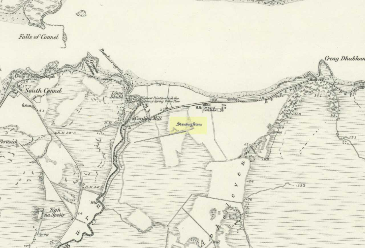
The Royal Commission for Historic Scotland (1974) recorded this “stone that formerly stood within the area now occupied by Connel Station,” which was thought to have been destroyed shortly before construction of the said building. Thankfully the Ordnance Survey lads recorded its position on their cartographic ventures here in 1871. Mr R.A. Smith (1874) also mentioned the site, albeit briefly, in his fine series of essays on the antiquities of Loch Etive, telling us:
“Above Connell Ferry we come to a small brook called Lusragan, and a few houses with a mill called Clachaleven. To the east, in a field above the road, is a large standing stone, and around it marks where others, well remembered, lately stood.”
But sadly it seems, these have all gone.
References:
Royal Commission for Ancient & Historical Monuments, Scotland, Argyll – volume 2: Lorn, HMSO: Edinburgh 1974.
The Scottish Royal Commission (1971) reported a very large
“standing stone that stood 185m NNW of Achmore House (that) was removed at the beginning of the 19th century. It was reported that is measured 4.9m in height (16ft), 1.2m in breadth and 0.2m in thickness.”
A prehistoric cairn seemed to have accompanied this monolith—as reported by Thomas Pennant in 1772—but it too has been destroyed. Pennant told us how the monolith was,
“a great rude column, sixteen feet high, four broad and eight inches thick.”
Not bad at all! It was still extant, although leaning to the southwest in the year 1790 (OSA 1791-9); appearing to have been removed about 1800. No trace of it remained when the Ordnance Survey lads looked here in 1869.
References:
Royal Commission for Ancient & Historical Monuments of Scotland, Argyll – volume 1: Kintyre, HMSO 1971.
Stone Circle (destroyed): OS grid-reference – SD 821 613
Also known as:
Druid’s Hill Circle
Druid’s Circle
Archaeology & History
Speight’s 1895 map – showing position of circle
Not included in any previous archaeological surveys of megalithic rings, this circle of stones was apparently visible from quite a distance away, sitting on the hillside where now there is woodland. It was described by the great Yorkshire historian Harry Speight (1892, 1895), though today it seems that all remains of it have vanished.
An early description of it came after an excursion to the site by local antiquarians, who told that “at Cleatop, about a mile to the south of Settle, are the remains of an ancient stone circle.” (Horsfall-Turner 1888) A few years later, Mr Speight gave us more details of the place, saying:
“A little above Cleatop Farm (near Rathmell)…is Cleatop Wood. Cleatop derives its name from the A.S. cleof, a rocky aclivity; Latin clivus, a bank or slope. Near the northeast side of the wood there was once a very noticeable Druid’s Circle, about 60 feet in diameter; indeed, Mr Thomas Brayshaw of Settle, informs me that within the memory of persons still living, it was so regular and well-defined that one or two gaps caused by the removal of stones could be easily distinguished. The eminence at the rear of the site has, from time immemorial, been known as Druid’s Hill.”
Some years later, that very same local historian Tom Brayshaw (1932) wrote:
“The Ordnance map marks, on the steep slope to the north of Cleatop Wood, ‘site of Stone Circle’. It needs a very keen eye to identify the few stumps that remain today, and it is deplorable that this most interesting monument, after enduring for so many centuries, has been destroyed during the last eighty years. In 1847 a description of the circle, as it then was, was sent to Captain Yolland of the Ordnance Survey.
“”I suppose the circle of stones in Cleatop High Park to be aboriginal British or Druidical remains from the following appearances: the circle is complete and the large stones are set on end, some of them several tons weight. The stones are twelve in number now standing, beside several others that seem to be rolled a short distance, as it is placed on the ascent of a steep hill and commands a beautiful and extensive prospect (more so than any given point of the same altitude in the vicinity). The circle is 36 feet in diameter.”
“A few stones were still standing in 1883. The hill above long bore the name Druids Hill. The Enclosure Acts passed towards the end of the 18th century greatly increased the number of drystone walls in the parish, and it is probable that many old stone monuments were destroyed in making them and in their subsequent repair”.
We have no references of burials or other excavations here to give us any idea of whether human remains had ever been found. It’s an intriguing place in the landscape though…and worthy of further explorations…
References:
Brayshaw, Thomas, A History of the Ancient Parish of Giggleswick, Halton & Co.: London 1932.
Horsfall-Turner, J. (ed.), ‘Antiquarian Excursion to Giggleswick and Settle,’ in Yorkshire Folklore Journal, vol.1, T. Harrison: Bingley 1888.
Speight, Harry, The Craven and Northwest Yorkshire Highlands, Elliott Stock: London 1892.
Speight, Harry, Tramps and Drives in the Craven Highlands, Elliot Stock: London 1895.
Also known as the ‘Stones of Islay,’ these two old stones can be found on the west side of the road between Port Ellen and Ardtalla, up the steepish wood-covered slope, just south of the conical fairy hill of Cnoc Rhaonastil.
Archaeology & History
In recent years, the Scottish Royal Commission commented that “they do not appear to be of prehistoric date,” yet include it in the Argyll survey (vol.5:65), just in case! The larger of the two monoliths is nearly 6 feet long (it was on the floor when I came here, many years back), and its smaller companion about 3 feet long (also on the deck!).
Folklore
In 1794, in the Statistical Account of Scotland, it was said that these two curious standing stones marked the grave of Yla or Yula, “a daughter of one of the kings of Denmark,” which is most unlikely. Between these two stones, folklore tells, is known as the Tomb of Yla – a Danish princess whom legend tells gave Islay its name.
The hill above these old stones was long known to be the place of the faerie-folk. Indeed, the Queen of Faerie herself lived here. Otta Swire told a fascinating old folktale of this place, whose nature will be know to some:
“The Queen was much troubled by the stupidity of human women, for in the fairy world wisdom is chiefly possessed by the women, since it is they who hold the Cup. After much thought, She decided to try to improve matters, so she sent out an invitation to all the women of the world to visit Her in Her hall in the knoll on a certain date. The invitation spread over the wide Earth – it was carried by the winds and the sea waves, by birds and by fish, even the leaves of the trees whispered it. And the women of the world were very much interested and they talked eagerly together. Some laughed at it, some said they were wiser by far than the Little People, some held that the Little People were cleverer and more powerful than they and that this might be a trap. Indeed, the word of women ‘heaved like hive of bee or hill of ant or byke of wasp.’ Soon, women from all over the isles began to arrive in Islay. Some came to see, many more to be seen, and a few came truly seeking wisdom.
“When the day dawned the hill opened, and into the wonderful hall within streamed the women. And a very wonderful hall it was, hung with bright cloths woven from nettles and fairy lint and dyed with blood of shell-fish and sap of plants in such colours as only the Little People can achieve. Skins of beasts were spread on floors and seats, a banquet set on shells of pearl lay ready on the many tables of wood and stone, and for each guest there was placed ready a beautiful cup formed from a blue-eyed limpet’s shell. A soft green light pervaded the hall. When all were ready and the watchers saw no more coracles on the waters or maidens climbing the green slope, the doors to the outer world were closed and in walked the Queen Herself. She was smaller than any of Her guests but far, far more impressive. She wore a dress of long ago but it suited well Her gentle, kindly dignity and Her face shone with a strange and lovely light. She carried in Her two hands a wonderful flagon and after her came her maids, each holding a similar one. Other maids hastily distributed the cups of shell and then the Queen walked slowly by, pouring into the cup of each of those who, in her heart truly desired wisdom, a few drops of the precious fluid from Her flagon, which held the distilled wisdom of the world throughout the ages. And as each woman drank those few drops she suddenly grew wise and saw and understood much she had never known before. Some were able to see much, others but a little, yet all benefited in their degree. At last, all who sought wisdom had received it and the elixir was finished. Just as the ceremony ended there came a hammering on the walls and the doors. The Little People looked out and, behold!, their hill was covered with late-comers who had arrived after the doors were closed and so had been unable to enter and were now too late to receive the gift. There is still a saying in Gaelic about a stupid woman: ‘She was out on the knoll when wisdom was distributed.'”
A saying I remember my old grandad telling a few folk a few times when I was young!
References:
Royal Commission on the Ancient & Historical Monuments of Scotland, Argyll – volume 5: Islay, Jura, Colonsay and Oronsay, HMSO: Edinburgh 1984.
Swire, O.F., The Inner Hebrides and their Legends, Collins: London & Glasgow 1964.
Although the lads at the Scottish Royal Commission (1974) initially described this site as a ‘Standing Stone’, it is in fact,
“an erratic boulder of granite roughly shaped in the form of a cross… It measures 0.8m in height, 0.6m in width at base, and 0.4m in width at the top…(and) the stone is supposed to have marked a boundary.”
The site was evidently of some mythic importance, as the great Cathedral of St. Moluag was built next to the stone — unless the giant cairn of Cnoc Aingil, 500 yards away, was to blame. A holy well of this saint’s name (an obvious heathen site beforehand) is also nearby.
Folklore
Although this stone was dedicated to swans, I’ve not found the story behind the name. There were no buried swans here, but local tradition told that this old boulder could give sanctuary to anyone who touched it, or ran round it sunwise. The Hebridean folklorist Otta Swire (1964) told that,
“anyone who claimed such sanctuary had his case considered by ‘the Elders.’ If they considered his plea justified, they ‘came out and walked sun-wise round the Swan Stone.’ If they did not approve of his right to sanctuary, they walked round it anti-clockwise and the man was then given over, not to his enemies, but ‘to Authority’ to be tried.”
This old tradition derives from well known pre-christian rites. Swire also reported that even in the 1960s here, “at funerals the coffin is always carried round the grave sun-wise before being laid in it.” An old cross placed in the Field of the Cross next to the stone was an attempt to tease folk away from heathen rites of the stone, but failed.
References:
Royal Commission on the Ancient & Historical Monuments of Scotland, Argyll – volume 2: Lorn, RCAHMS: Edinburgh 1974.
Swire, O.F., The Inner Hebrides and their Legends, Collins: London 1964.
Troublesome really, as it’s got lost somewhere amidst the undergrowth. From the valley bottom at Apperley Bridge, take the road-then-track which goes up thru the Calverley Cutting (as locals call it), turning left along the dirt-track just as the track begins to slope uphill. Go past the detached house in the edge of the trees and shortly past there is a small footpath taking you into the trees on your left, Walk down and along here, near the bottom of the tree-line above the walling. If you find it, let us know!
Archaeology & History
Included in Boughey & Vickerman’s (2003) survey as ‘stone 12’ – it was first described by Sidney Jackson in 1954, who later gave us a map and drawing of the stone. I looked for it several times x-number of years back, but never found it (though was led astray a little by the profusion of Amanitas in the locale!). Comprising at least 18 cup-markings on a generally flat rock surface, to this day the carving remains unfound, though is probably under the herbage hereabouts. The same fate seems to have befallen the West Woods 1 and West Woods 2 carvings in another part of the same woods. Does anyone know what’s become of them?
References:
Bennett, Paul, “The Undiscovered Old Stones of Calverley Woods,” in Earth no.2, 1986.
Boughey, Keith & Vickerman, E.A., Prehistoric Rock Art of the West Riding, West Yorkshire Archaeology Service 2003.
Jackson, Sidney (ed.), ‘Calverley Wood Cup-Marked Rock,’ in Bradford Cartwright Hall Archaeology Group Bulletin, 1:1, 1954.
Jackson, Sidney (ed.), ‘Cup-Marked Boulder in Calverley Wood,’ in Bradford Cartwright Hall Archaeology Group Bulletin, 1:7, 1955.
Jackson, Sidney (ed.), ‘Cup-and-Ring Boulders near Calverley,’ in Bradford Cartwright Hall Archaeology Group Bulletin, 1:16, 1956.
Legendary Rocks (destroyed): OS Grid Reference – SE 187 545
Archaeology & History
The original position and nature of this site was difficult to ascertain and left us wondering whether the place was once a monolith, stone circle or legendary rock outcrop, as seemed that there were no remains left of the place. Aswell as that, the only reference we had that describing this place is from William Grainge’s History of Knaresborough (1871), where he wrote:
“At Busky Dike, a place between Cragg Hall and Fewston, according to the report of tradition, there once existed a Druidical altar; and that same venerable authority declares that the same place is the haunt of a Bharguest; and many of the country people yet tremble as they pass that place in the dark, for fear they should meet that strange and terrible beast.”
The latter remark would indicate that something decidely pre-christian was once of renown here. But it seems that an old rock outcrop was the place in question here, found in the now wooded area on the south side of the Busky Dike Road, just northwest a half-mile outside of Fewston itself. It would be good to hear more about this place…if anyone knows owt…
References:
Grainge, William, The History of Harrogate and the Forest of Knaresborough, 1871.
Grainge, William, The History and Topography of Little Timble, Great Timble and the Hamlet of Snowden, William Walker: Otley 1895.
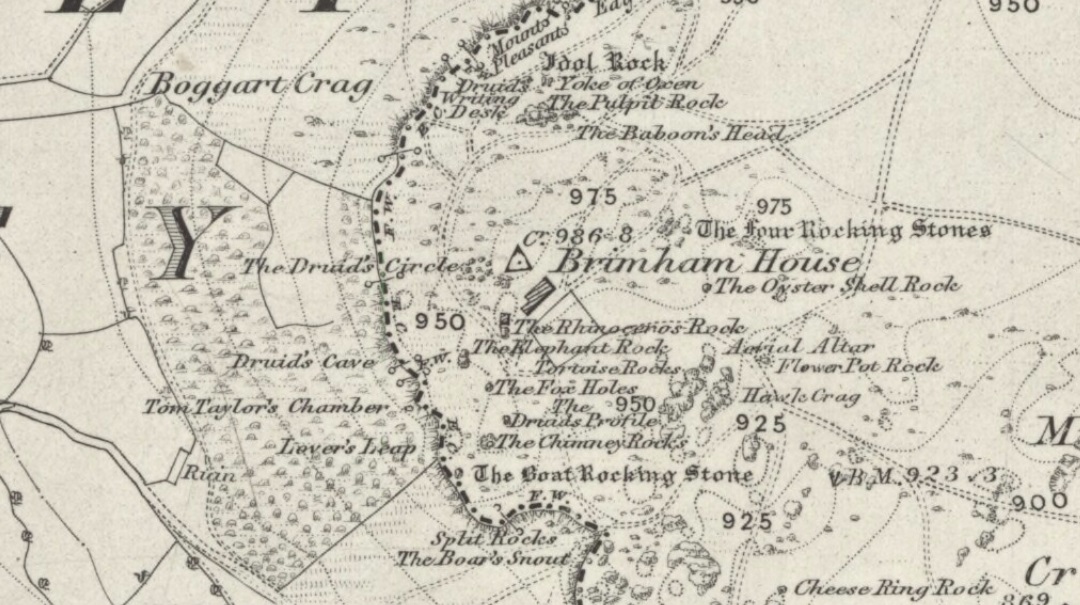
A site that was illustrated by the early Ordnance Survey lads between the haunted Boggart Crag and Brimham Rocks to the south, I haven’t thoroughly explored this area so don’t know if anything at all remains of what was described. It may or may not have been an early folly. The earliest reference to this missing circle comes from Mr Hayman Rooke’s (1787) essay on the Brimham Rocks complex in Archaeologia journal. Described in context with other prehistoric remains in the locale, Mr Rooke said,
“About a quarter of a mile further to the west (of Brimham Rocks) is a Druid circle, with a vallum of earth and stones, thirty feet diameter. It is exactly of the same construction as those on Stanton Moor, in the Peak of Derbyshire. There are likewise several small tumuli. Thirteen of them are ranged in a kind of circle, the largest not above eighteen feet in diameter. They are formed of earth and large stones. Two of these I opened; towards the bottom the effects of fire appeared on the stones; and ashes were scattered about, but there were no urns to be found.”
This description was echoed a few years later by Ely Hargrove (1809) and reiterated by Godfrey Higgins (1829) in his work on the Druids, but neither authors added anything new (strongly implying they never actually saw this ‘circle’). The last description I’ve found of the site is in Mr Speight’s (1906) survey — which gives the reality of the site considerably more credence! He told us:
“About 80 yards west of the Cannon Rock is a large tumulus, and about 300 yards still further is a Druid’s Circle, thirty feet in diameter, mentioned by Hargrove in 1809.”
But that’s it! Nowt else! It would seem from Hooke’s initial writing, that we are perhaps looking at a lost cairn circle in this locale, but until someone finds it we will never know for sure.
Intriguingly, there are a number of other prehistoric remains not far from this seemingly lost ‘circle’. There’s a large standing stone not far away on Standing Stone Hill a half-mile south (kinda gives the game away really, dunnit!?) which I first saw as a kid; some cup-and-ring stones nearby; and the seemingly lost tumuli of Graffa Plain, southeast of Brimham Rocks, showing that prehistoric folk were up to the usual tricks nearby. But the ‘circle’ is seemingly lost. Is there anyone out there who knows anything more about yet another one of Yorkshire’s lost stone circles? More information about the circle or the tombs would be very welcome!
References:
Hargrove, Ely, The History of the Castle, Town and Forest of Knaresborough, Hargrove & Sons: Knaresborough 1809.
Higgins, Godfrey, The Celtic Druids, R. Hunter: London 1829.
Rooke, Hayman, “Some Account of the Brimham Rocks in Yorkshire,” in Archaeologia journal, volume 8, 1787.
Speight, Harry, Upper Nidderdale, with the Forest of Knaresborough, Elliot Stock: London 1906.
Stone Circle (destroyed): OS Grid Reference – SE 426 099
Archaeology & History
On the southern outskirts of Brierley and the northeastern edge of Grimethorpe is the curiously-named site of Ringstone Hill. I say “curiously,” as there are no physical remnants of anything which would presently tell us of there ever being such a ring of stones here — well, nothing authentic anyway! Some doods stuck a modern ring of stones here, but it’s pretty obviously a recent construction (apparently 1990-ish); but sometime in the not-too-distant past another circle, very probably prehistoric, could be found here…
First mentioned in 1591, the original stone circle which gave this place its name has seemingly gone; but the hill which preserves its name is a prominent place in the landscape, and this was very probably of some relevance to the builders. On the eastern side of the hill were two large oak trees known locally as Adam & Eve, or the Well-Bred Oaks: the first name implying a creation-myth story which may have related to the ring of stones. It also stands at the edge of the old boundary line along which, somewhere, was another tree called the Gospel Thorn, “where the gospel was read when beating the bounds.” (A.H. Smith 1961: 1:269)
This was a theme explored and developed in Mr Gomme’s (1880) old work on ancient meeting, or moot spots. He told:
“Ringston Hill, an eminence partly natural and partly artificial, is near a point at which meet the three wapentakes (district boundaries, PB) of Strafford, Stancross and Osgodcross. This mound appears to be connected in some manner with the early political state of this district. It was a place of rendezvous in the time of the Civil War; for in the accounts of the township of Sheffield in 1645 occurs this entry: ‘In money, coats and the charging of a guard which went to Ringston Hill with five men that were pressed, £4, 13s, 3d.’ (Hunter’s South Yorkshire ii, 407)”
From Otley go north straight over the river and upwards into the countryside for nearly two miles (past the TV mast on the right). As you reach near the top of the hill, there’s a turn to your right. Go on here for a hundred yards or so, then walk along the footpath to your right. After a few hundred yards, keep your eyes out for the stone just through the gate, in the walling on your left.
Archaeology & History
Although we see named on the 1853 Ordnance Survey map the respective place-names of Bride Cross House and Bride Cross Allotment, the first literary reference to any site here as a standing stone appears to be Eric Cowling (1946) who, when commenting on the pagan tradition and folklore of ancient sites, told that
“The name of Bride Cross Farm, Dob Park, is very significant, for at the meeting place of several tracks to the south-east is a squat standing stone built into a wall and marked as a boundary stone, which was probably Brides Cross.”
Bride Stone, Farnley MoorBoundary markers on top
Although I’d read about this place as a kid, it was Graeme Chappell who first brought me here some twenty years back, in one of our many exploratory forays into the prehistory of this area. It’s a nice fat squat standing stone, similar in stature to the more famous Bull Stone near Otley Chevin, a few miles to the south — though our Bride Stone here is about half as high. Only about three-feet tall, it stands by the gate at the wall-side about 200 yards down the footpath from the Dob Park Lodge road and does seems to have been used as a boundary marker, as the letters “F.F.” are carved deeply on top of the upright (possibly denoting the Fawkes family of Farnley).
Cowling’s assertion that this old stone accounts for the ‘Bride Cross’ place-name is probably right, as the site is roughly midway between the respective place-names of the House and Allotment. There is an old field-name of Crosse Close in the vicinity, from 1692, but I haven’t located it. If such a cross ever existed nearby (most likely, it’s gotta be said), it’s obviously the relic which left the place-names — though the standing stone was certainly here first! As yet, we’ve found no references to this place before 1853…which can’t be right…
Folklore
Seems to be a petrification legend in here somewhere. Although the short tale doesn’t say as much, it is supposed to have got its name through “the murder of a bride, rejected by a suitor, on her return from a wedding.” Indeed, I’d go so far as to say ‘fertility’ as well!
Eric Cowling (1946) really stuck his neck out and reckoned sacrifices occurred here in the not too distant past. This may relate to the nearby Haddock Stones, a few hundred yards south, thought to derive its name from a cairn and ‘altar stones.’
References:
Bennett, Paul, The Old Stones of Elmet, Capall Bann: Milverton 2001.
Cowling, E.T., Rombald’s Way, William Walker: Otley 1946.
Phillips, Guy Ragland, Brigantia — A Mysteriography, RKP: London 1976.
Smith, A.H., The Place-Names of the West Riding of Yorkshire – volume 5, Cambridge University Press 1961.
")