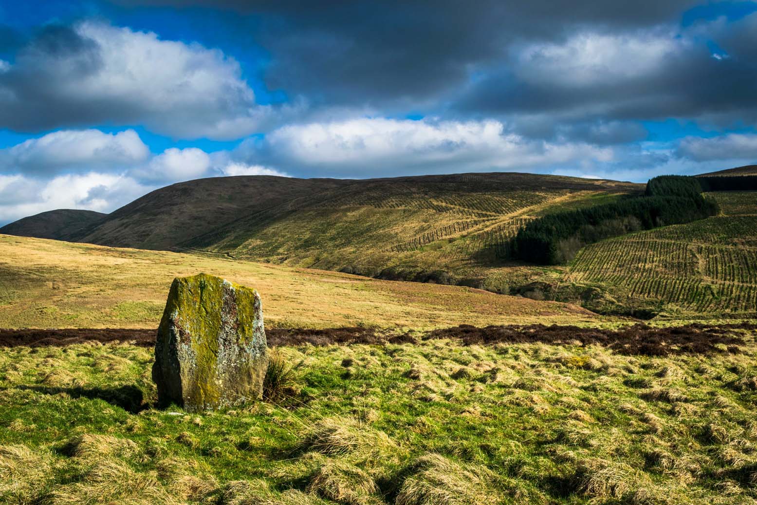
If you’re not into the walk, get the bus running NE between Dunblane and Greenloaning — the A9 — getting off at the Little Chef on the dual carriageway and cross the road, walking up the track to Upper Whiteston Farm (the owners here are very helpful). As you walk up the track you’ll notice the large upright in the edge of the field a coupla hundred yards to your right. That’s the one!
Archaeology & History
This is a mightily impressive site if you’re into yer megaliths! When it was visited and measured by Mr Hutchinson (1893) in the 19th century he found it to be 9ft 4 in tall; and although it seems quite isolated at first sight, we find that there is another large stone companion laid down not far to the north of here which may have had some relationship with it . But that aside… There are also as many as eight cup-markings on the stone’s eastern face: one large one and seven smaller ones, in no particular order as usual! It was these cup-marks that gave me the impression there was once a burial associated with the stone, but the archaeology records seem silent on such a matter; though folklore tradition tells another story…
Folklore
Mr Hutchinson (1893) told that the legend attached to this stone appears to be “of quite recent date.” He said how,
“In the district the stone is known as the MacGregor Stone, and the tradition accounting for the name is to the effect that here a countryman was sacrificed by the followers of Rob Roy, when forming for the engagement on Sheriffmuir, in order to satisfy the ancient Highland superstition that first-blood was an infallible omen of success… The tradition is precise enough to state that a man of the name Dawson was seized in the adjoining hamlet of Whiteheadston (for such is the orignal name) as a whig, and therefore a foeman and proper victim. Dawson, however, suspecting the intentions of the captors, vehemently professed himself a supporter of King James and was left off. But another inhabitant of the hamlet not so acute or not so hypocritical, was immolated at the stone.”
Hutchinson however, doubts the accuracy of the tale and suggests that the local name of the MacGregor’s Stone derives from the fact that the monolith stands upon land once owned by the MacGregors of Balhaldies, countenancing that the stone “is of much earlier date than the MacGregors of Balhaldie or any other sept of the Children of the Mist.” I think he’s got a point!
References:
Hutchinson, A.F., “The Standing Stones of Stirling District,” in The Stirling Antiquary, volume 1, 1893.
From the Askwith Moor Road parking spot, walk up the road for about 500 yards and head to your right (east) onto the moor. Walk past the upper side of the disused quarry and through the heather for about 200 yards until the moorland slopes down and you’re on another flat moorland ridge. You should now be stood on the edge of the Snowden Crags Necropolis or cairnfield. There’s a large patch of bracken near the top of Snowden Crags in the middle of the prehistoric cemetery. That’s the spot!
Archaeology & History
Very little has been written of this site and for years several of us have wondered whether or not a stone circle was the antiquity that was being described in the only singular reference of the place, mentioned almost in passing in Mr Cowling’s (1946) fine survey of this area more than fifty years back, where he reported:
“A large circle of heavy material, some thirty feet in diameter, is isolated on the shelf above Snowden Crags to the west.”
But despite the various explorations of me and a number of other students on these moors over the last 20-30 years, Cowling’s curious singular reference (which some have taken as an error of judgement on his behalf) has remained a mystery. Until now!
South & west portion of the ring (photo credit: Geoff Watson)The complete circle, looking NW (photo credit: Geoff Watson)
Thankfully, with the help and attention of the hardworking Keighley volunteer Michala Potts on Thursday, 20 May, 2010, this large and very well-defined antiquity has been relocated — and a damn fine find it is indeed! It would appear (unless someone has notes to the contrary) that when Cowling did his extensive walkabouts on these and adjacent moors, this Snowden Crags Circle was much overgrown in heather and bracken; and I think we can safely assume this due to him making no further remarks regarding the site. Indeed, it would seem that Cowling’s consequent silence on the matter would lend us to think he never caught good sight of this “large circle” ever again. And upon these moors, that’s easily done when the heather gets deep up here! (numerous cup-and-ring stones on these and other northern moors still lay hidden amidst moorland undergrowth, awaiting rediscovery as a consequence of the deep vegetation) But thankfully now we have a good view of the place.
Wrongly ascribed by Neil Redfern of English Heritage to be a part of Scheduled Monument Record number 28065: Cairnfield, Enclosures, Boulder Walling, Hollow Way and Carved Rocks (it’s actually a short distance north of SMR 28065), the site here was relocated during one of The Northern Antiquarian exploratory walks, assessing the extensive walling, settlement pattern and prehistoric graveyard that scatters the central and northwestern section of the moors here. Michala Potts stopped and shouted for Dave Hazell and I to come and have a look at something she’d found whilst we were carefully peeling turf back from a previously unrecorded site about 100 yards away.
“What is it?” I asked; expecting just another small tomb or new cup-and-ring stone. But her tone of voice was different this time.
“I think you’d better take a look at this,” she emphasized.
As we walked through the shallow heather towards her, it became obvious she was standing in a rough circle of dead bracken, unbroken by the lack of rain over the previous months. We’d actually walked past it a couple of times the previous week and gave it no attention due to the depth of the dead vegetation covering the area. But this time it was different. I got within 50 yards of where Mikki was stood and my footsteps slowed; a couple more steps perhaps; then I stopped dead in my track. My arms lifted up and I held my head gazing at what she appeared to be stood in.
“Aww my god….” I said — transfixed at what was in front of me (I’m easily pleased aswell!).
Snowden Crags circle, looking west (photo credit: Geoff Watson)
I’m not quite sure how long I stood there with my head in my hands. Ten seconds or so. I couldn’t really say. I think it was when Dave caught up to where I stood, rooted, and appeared at my side. We walked a bit closer to make sure that what we could see wasn’t just another one of those curious shapes in the landscape that you find when seeking out prehistoric sites and turn out to be bugger all — but it wasn’t. Instead, Mikki Potts had stumbled upon an average-sized ring of stones, between 1-3 feet tall, and about 13 yards across, with what seemed like an entrance on its southern side, seemingly untouched in the middle of the mass of decaying bracken! It was an exciting find — as it’s not everyday that you come across a previously unrecorded stone circle. But, once we’d calmed down and walked round and round the site to make sure that something man-made was under our feet, we decided to make our way home (we’d been on the moors all day) and get back up to have a more detailed look at the place in a few days time. On Tuesday, May 25, we went back up for a second time and had a better look at the place…
It was another lucky day. For before we even reached Askwith Moor, Mikki pointed out what looked like a small cup-marking on a stone yards from the edge of the River Wharfe. We brushed off a bit of the dusty earth and were greeted the single cup-marked stone we’ve named the Riverbank Stone. It sat there all alone and dusty and we were very tempted to look for more potential carvings along the riverbank, but the Snowden Crags site was calling for attention and so up the hill we walked.
The ring of stones was still covered in a carpet of dead bracken and also had the new shoots of Spring emerging from the Earth, so we spent the next few hours picking up much of the dead bracken and carrying it beyond the outskirts of the circle, hence enabling us to see with greater clarity the monument Mikki had found a few days previously. The hot sun shone down on us all day and it took longer than we expected to shift all the bracken; but eventually, once we’d done it, we were looking at a very distinct man-made circular monument, measuring 13 yards by 12 yards across and, at its highest point, not even three feet above the present ground level. But today’s ground level is certainly much higher than it was when these stones were first placed here — at least 12 inches higher.
Rubble bank, NE-SE section (photo credit: Geoff Watson)
When Mikki first clapped eyes on the place, only a few small upright stones were sticking up amidst the mass of compacted bracken, but once all this had been brushed off we could see the stony earthworks averaging 18 inches high around the edges; and in places this outer ring is nearly 6 feet across. The ring consists mainly of smaller packing stones (perhaps thousands of them) between a number of larger upright stones — a dozen of them — making up the perimeter; but much of this perimeter is still considerably overgrown in compacted vegetation that’s prevented us seeing the ring in its proper glory: what archaeologists in the past have called a rubble bank. On its southern side is what appears to be an entrance, i.e., in this part of the circle there are no larger stones at all and only a handful of small stones have been noticed; but we must take into account the fact that we’ve done no excavation work here and this “entrance” may in fact be illusory, as the centuries of compacted vegetation (in all probability at least 12 inches deep) could be overlaying an unseen portion of the ring. This “entrance” is about 2 yards across.
The circle has similarities in size and design to the better-known site of Roms Law on Ilkley Moor. The difference between the two however is Roms Law has been robbed, whilst the Snowden Crags circle hasn’t even been catalogued. Yet there is a distinct anomaly here.
As we walked through the southern “entrance” and into the circle, we noticed what seemed to be some form of internal walling running roughly north-to-south. This “walling” started about three yards between the southern “entrance” and the inside of the ring, but then it ran roughly through the centre and all the way to the northern perimeter. This was indicated by a distinct rise in the ground which, as you walked over and stomped your feet, proved to be a mass of numerous small stones seemingly a few inches under the ground, some of which were poking through the Earth’s surface. This ingredient alone made me stop and wonder about the nature of the site. Had we come across a cairn circle of some sort? Or were we in fact stood in the middle of a small walled enclosure, which itself sits in the middle of this prehistoric graveyard? Indeed, was this walled enclosure a potential living quarter: some sort of large hut circle with a wall through the centre splitting it in two? It was hard to say for sure. On another visit to this site a couple of weeks later, in the company of Geoff Watson, Paul Hornby and Dave Hazell, this potential internal walling was given a bit more scrutiny.
We were dying to get our hands and feet digging at the heart of this ring of stones but — as yet! — we’ve managed to restrain ourselves. Although carrying off the mass of dead bracken has dislodged a couple of the small fist-sized stones at the edge of the ring (we carefully placed ’em back into position; yet it was only as much as you’d unintentionally disturb if you walked over the place a few times), we needed to use a couple of small brushes to have a look at this apparent internal walling running through the middle of the ring. But after carefully brushing off the dry dead earth, we found this “walling” was nothing of the sort! Instead, it seemed, someone at some time in the past had beaten us to this place! The central walling was, in fact, where someone had dug into the central region of the circle — probably looking for treasure or other wealthy valuables — and in doing so had dislodged a great number of the small stones that were initially in the middle of the ring, and in doing so pushed them up into small piles of stones, away from their original central position, creating an obvious long line of rocks which, once covered with dead vegetation, gave the impression of it being a length of walling. We also found that the mass of rocks that were around the centre of the ring also spread outwards covering all of the ground inside the outer kerb of stones — probably thousands of them. Geoff called this trench in the middle, the Robber’s Trench!
This begged the question: who the hell had been here, dug out a trench in the middle of this cairn circle (possibly taking out whatever remains were in the middle) centuries before the site had even been catalogued? It didn’t seem like it could have been Mr Cowling, as the covering vegetation was much more than a mere 50 years of age; and Cowling would very likely have reported any finds that he might have made here. So it is a mystery that needs solving.* Again, an accurate archaeological excavation would be invaluable here — but I wouldn’t hold your breath. Archaeological officials don’t seem interested in helping here. I was informed by Neil Redfern of the archaeology department of English Heritage for North Yorkshire that they are unable to support any funding that might help towards any decent analysis of this important archaeological arena (probably spent all their cash on prawn sandwiches and tedious autocrats, as usual).
So what we have so far is this: a large flattened circle consisting of at least a dozen upright stones that define the edges. Between these uprights are hundreds, perhaps thousands of smaller stones, making a rubble bank of a near unbroken circle, apart from where there seems a small entrance on its southern side. Inside the circle is a scattered mass of many small stones, typical of cairn material, filling the entirety of the monument; but the central region has been dug into at some time in the past, by persons unknown. It sits on a flat plain of moorland amidst the Snowden Crags Necropolis with around 30 other small cairns. But this particular site is several times larger than all the others, probably indicating that whoever was buried/cremated here was of some considerable importance in the tribal group: a local king, queen, tribal elder or shaman. Whoever it was that this monument was made for, the landscape reaching northwards from here looks across to the giant morphic temples of Brimham Rocks and the heavenly landscape beyond and above them. It is very likely that the Lands of the Ancestors this way beckoned…
References:
Cowling, Eric T., Rombald’s Way: A Prehistory of mid-Wharfedale, William Walker: Otley 1946.
Huge thanks for the help, assistance and photographs of this newly discovered site — and others nearby — to Michala Potts, Dave Hazell, Paul Hornby and Geoff Watson.
* There is a legend that tells of gold and treasure found at a nearby pre-christian well, but this site is a mile to the north of here. Another nearby treasure legend is that of a chap called “Robinson”, who came upon tons of wealth from an unknown source, enabling him to build the eloquent Swinsty Hall a mile northwest of here (though such a chap didn’t actually build Swinsty!). Perhaps there’s some grain of truth somewhere down the line about someone finding some treasure hereby…perhaps here…perhaps not!
AN APPEAL TO SOME DECENT RICH CHAP FOR SOME MONEY TO ENABLE EXCAVATION HERE!
This site and the surrounding monuments have received no archaeological attention of any worth. If it wasn’t for the fact that us amateurs had explored these (and adjacent) moors, this cairn circle would remain unknown, many of the cup-and-rings upon these moors would remain unknown, the extensive enclosures and walling (of indeterminate age and function) would remain unknown, many prehistoric tombs would remain unknown, etc. It is clearly evident that we have quite extensive domestic and ritual remains covering this small moorland region, from the neolithic period onwards. In the event that anyone reading this with a healthy financial backing behind them could work out a financial strategy enabling us to accurately excavate this and the adjacent monuments, please get in touch. We need an archaeologist to be paid for in order that we can do the duties correctly, but there is a group of a dozen volunteers willing to put a lotta work in to do the right job in this and the surrounding sites. Is there anyone out there who has the finance to enable this? I’m serious! Or are these important sites merely going to be left alone for the elements to consume and disappear over time? Surely there are one or two rich antiquarians left in this country who, as in times of old, are willing to help in the investigation of our country’s ancient monuments? Does anyone out there know how we can get the ball rolling?
An intriguing entry inasmuch as we don’t know the full history and nature of the site. Whether this site was the “druidical circle” mentioned in the 1791 Old Statistical Account of Scotland ” upon the heights of Sheriffmuir,”(vol.3, p.210), we cannot be sure. The site was certainly described by Mr Hutchinson (1893) more than a century ago as a “stone circle”, but earlier still in a short piece in the Stirling Journal of May 5, 1830. It read:
“About eight miles from Stirling by the Sheriffmuir Road, near a place called Harperstone, there is a remarkable circle of stones, supposed to have been a druidical place of worship of old. The site of this circle is rather uncommon in this country — being on the back summit of a high hill, one of the Ochils called the Black Hill, and exposed to every wind that blows. It is about two english miles south of the present roadway.”
The writer’s notes then told of some curious finds by this circle, giving the impression that it may have had another function: perhaps a cairn of sorts; perhaps an ancient building — we may never know. Nevertheless, his information is intriguing.
“Tradition records two remarkable circumstances connected with this druidical circle, which may perhaps be worthy of being preserved. About the middle of last century (c.1750) there were dug up at the foot of the larger stones three vessels of clay of antique shapes, containing coins of very ancient date, which were long preserved by Monteath of Park, but are now, we regret to say, lost. So late as 1770, these coins were, it is said, to be seen at Park House, all of gold. About the year 1715, some stones on which had been engraved inscriptions were dug up at the same place; and at a previous period specimens of ancient Pictish armour were dug up from the bowels of this hill, which had been carefully deposited of yore some feet below the surface in crypts of curious description.”
When Mr Hutchinson came to explore this region in search of the stone circle, his nose took him to a site a few hundred yards north of nearby Harperstone Farm, where he found a large stone:
“It is 9 feet long by 6 feet across on the top, is 3 feet thick and measures 26 feet round. This appears to have been a centre stone, and a surrounding circle is traceable more or less distinctly — moreso to the west and north, less so to the east and south. The radius of the circle is about 15 yard, and a similar distance separates each of the larger stones yet traceable in the circle. The ground beside the great central stone appears to have been excavated…”
Black Hill, Sheriffmuir, looking eastArc of 3 stones in large ellipse
But it would seem that Hutchinson’s site and the one described in the Stirling Journal of 1830 are two distinctly separate items if their relative topographical descriptions are to be accepted. No doubt — like many a-local who’s found these same written accounts — when we visited and wandered back and forth over the Black Hill site in Autumn 2010, we were as puzzled as others before us in finding nothing on the named Black Hill. Nothing that could remotely be viewed as the circle described was anywhere in evidence. The only thing that we found of any potential was on the flat below the southern ridge of the hill, heading towards the small copse of trees, where is a possible ring of seven stones, albeit a low one, in an ellipse formation. The ground was much overgrown and a spring of water emerged from the edge of where might have been an eighth stone. The photo shown here was the best we could get of the site. It’s unlikely to be the place which Messrs Hutchinson and company wrote about.
A more detailed examination of the landscape around this ‘Harperstone Circle’ is needed.
References:
Hutchinson, A.F., “The Standing Stones of Stirling District,” in The Stirling Antiquary, volume 1, 1893.
Following excavation work on this denuded megalithic ring in 1974 and 1975 under the joint auspices of the Islay Historical Works Group (IHWG) and the Hunterian Museum of the University of Glasgow, under the direction of archaeologist Dr Euan MacKie (1976), with the intent of actually restoring the site to what they thought was its former glory by resurrecting the fallen monoliths in this ring of stones, some intriguing facts came to light. Dr MacKie wrote:
“This site stands on a low, shallow knoll about a mile from the sea and with an extensive peat bog to the west. Before excavation the stone ring consisted of a rough oval of two standing stones and ten fallen ones, the latter being partly or nearly completely buried under the turf. The dimensions of the ring were about 45 by 40 yards. The excavations were based on a 6m grid and the ain was to explore as much as possible the perimeter of the ring and part of the interior. In this way it was hoped to identify the sockets from which the prone monoliths were assumed to have fallen and thus to discover the exact positions at which they were to be re-erected…
“It soon became clear that the prone monoliths had not in fact fallen out of their sockets. All of them lay on the old ground surface under the peat which had evidently begun to grow — in the 8th century BC according to one C-14 date — after the site had reached its present condition. Some stones had no socket next to them and a number of sockets were found without adjacent stones. Several stones lay next to sockets in such a position as to make it clear that they had never been set up. The site had evidently been abandoned in the middle of construction and those sockets already dug were allowed to fill slowly with rubble and silt. One socket was discovered which had been deliberately filled up, confirming that some change of plan had occurred before the final abandonment. Cultoon is the only stone circle apart from two phases of Stonehenge to have revealed evidence of never having been completed. (my italics, Megalithix)
“The finds were few and consisted of mesolithic flint microliths and some larger, presumably neolithic flints. The former were all on and in the buried topsoil — the circle builders’ ground surface — while the latter were on the land surface and in the lower part of the peat; these last included scrapers and are hollow-based points of Bronze Age type. Of particular interest was the discovery of caches of flint flakes in the peat next to the two standing stones. They appear to be deliberate offerings and suggest that the site retained its sanctity for some centuries after its abandonment.”
…to be continued…
References:
MacKie, Euan, “Cultoon, Islay,” in Glasgow Archaeological Society Bulletin, No.2, 1976.
From Sabden village, walk up the Clitheroe Road towards the hairpin Nick o’ Pendle, but take the turning left 100 yards before the Nick. Walk along the dirt-track for less than 100 yards, watching for the small upright on the right-hand side of the track. You can’t really miss it!
Archaeology & History
The Coffin Stone
To be found on the far southern flanks of Pendle Hill, the Lancashire writer and historian, John Dixon,* brought us to this little-known stone a few days back — and gave us the history of the place. (Dixon 1993) He pointed out how it’s situated right alongside the legendary cross-Pennine prehistoric route that was labelled ‘Rombald’s Way’ by Eric Cowling. (1946): an important trackway which ran from coast to coast, allowing for the passage and transmission of flints, salt and early metals carried for barter and other uses. What may be another standing stone is on the nearby skyline a couple of hundred yards east; and on the slopes either side of here are the prehistoric tombs of Jeppe Knave Grave and the Devil’s Apronful (amongst others). A fine little standing stone!
Folklore
The name derives from it being a place where, in bygone days, when coffins were carried along the ancient routeway hereby, it was rested by this stone. As John Dixon (1993) told:
“It was used to mark a resting point for coffins en route from Pendle Forest to Whalley, allowing the mourners to refresh and pray by the curative Marion well, in a time before the ‘Newchurch’ of St. Mary was established at Goldshaw Booth in 1544.”
…and from another angle
The Marion Well he mentions is more popularly known as Our Lady’s Well and can be found a hundred yards up the hillside above our Coffin Stone. If you walk up the slope you’ll see the site emerging where a small boggy pool appears on the hillside, and the course of the small stream marked by the reeds growing down the grassy slopes. Although it became very much a Roman Catholic practice to venerate the Virgin Mary by this old well, the ritual was of course a much older heathen one.
John has also reminded me to mention “the fossil markings on the side of the stone – some plant from a former age” which you can see curving up from the bottom of the upright.
References:
Cowling, Eric T., Rombald’s Way: A Prehistory of Mid-Wharfedale, William Walker: Otley 1946.
Dixon, John, Journeys through Brigantia – volume 9: The Ribble Valley, Aussteiger Publications: Barnoldswick 1993.
* John is the author of many fine historical travel guides, including the Journeys through Brigantia series. See the titles in the Lancashire Bibliography and Yorkshire Bibliography for a more complete listing of all his books to date. If you wanna buy any of his works, or make enquiries regarding them, email John at: lancashirebooks@fsmail.net – or write to him direct, at: John Dixon, Aussteiger Publications, 21 Lowergate, Clitheroe, Lancashire BB7 1AD.
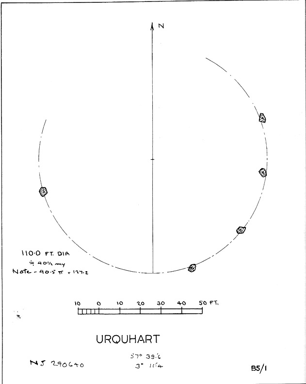
Described in early local history journals, this stone circle of many names is composed of mainly small upright stones — though one of them stands nearly six feet tall — yet it has quite a large diameter of 110 feet (or 40.4 megalithic yards). Alexander Thom (1980) measured its circumference as being precisely 127 megalithic yards. It is thought to have originally consisted of twelve stones, but today only five remain. And in a landscape where recumbent stone circles reign supreme, Aubrey Burl (in Thom, Thom & Burl 1980) thought the lay-out of the site suggestive of just such a monument, saying:
“The apparent grading of the stones towards the S-SSW and the 19th century reference by the Minister of Urquhart to “nine tall stones in a circle, two of them at the entrance to the altar” suggest that this may have been a recumbent stone circle, from which the recumbent and its flankers have subsequently been removed. It is noteworthy that the westernmost stone has several small cupmarks on it, a pillar which would have been close to the recumbent in that restricted area where cupmarks are to be found in recumbent stone circles.”
A singular TNA profile entry of the said cup-marked stone will be added in due course. The middle of the circle was dug sometime prior to 1870, but no human or other remains were found.
Folklore
Described by two local ministers as ‘Nine Stanes’ back in Victorian days, with at least one of the stones being recumbent, it was the great Fred Coles (1906) in one of his many articles on the megalithic remains of Scotland who narrated the following tale, told to him first-hand by a local man called Mr T. Geddie, after some of the standing stones from this circle were removed in the nineteenth century.
“One of the stones,” wrote Mr Geddie, “was to be taken away to be built into a new steading at Viewfield. Mr Brown thinks this was prior to the building of the Innesmill steading, which dates from 1843. No sooner had the Stone been deposited in the toon, however, than uncanny signs and omens began to manifest themselves, and it was resolved to get rid of it. While it was being taken back to its original position, the horse stuck or fell when taking a somewhat steep little brae, and the Stone was taken no further, but buried where it was. The spot it about 80 or 100 yards from the circle.”
Grinsell (1976) also tells the tale that if you visit the circle at midnight and walk round the circle three times, the devil can appear.
References:
Coles, F.R., ‘Report on Stone Circles Surveyed in the North-East of Scotland, Chiefly in Banffshire’, in PSAS 40, 1906.
Grinsell, Leslie V., Folklore of Prehistoric Sites in Britain, David & Charles: London 1976.
Thom, A., Thom, A.S. & Burl, Aubrey, Megalithic Rings, BAR 81: Oxford 1980.
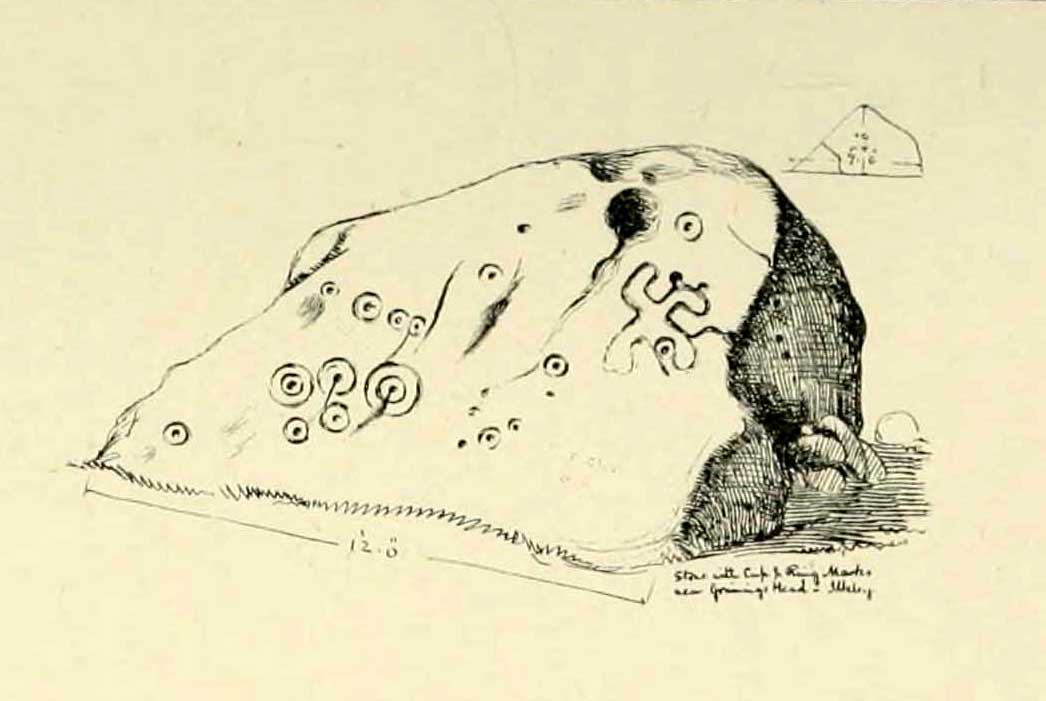
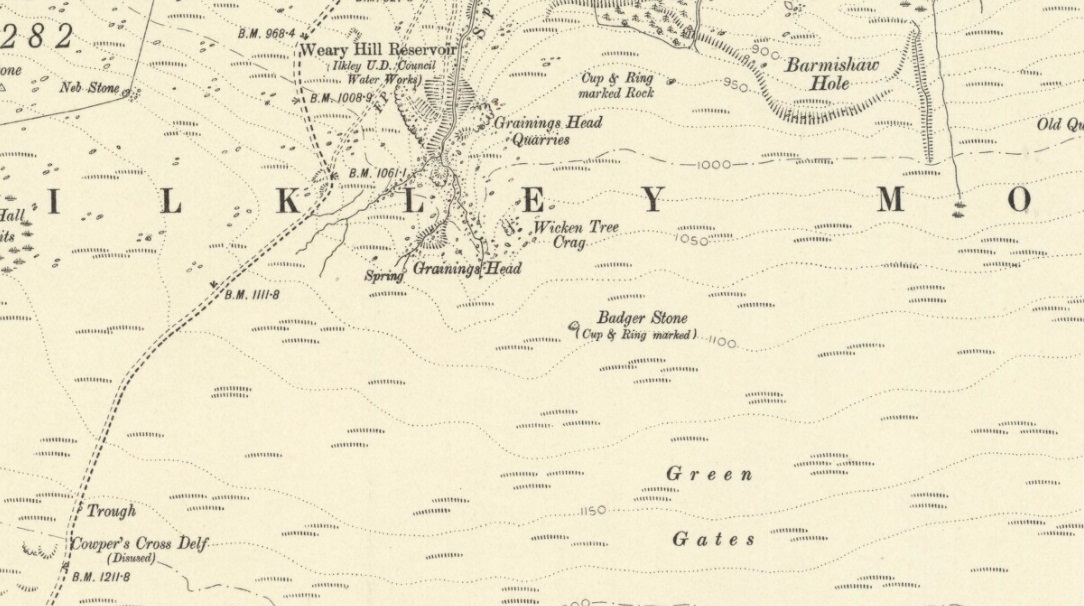
Although there are several routes to this site, for those who are not used to walking or find maps difficult to read [get a life!], it is best approached from the Ilkley side of the moor. Follow the old track that cuts the moor in half past the remains of Graining Head quarry where the moor begins to level out. Once here cut straight east until you find the footpath which, after a while, you will see leads to a wooden seat right in the middle of nowhere. Here is our Badger Stone.
Archaeology & History
An eroded but quite excellent cup-and-ring stone — one of the very best on Ilkley Moor — comprising nearly a hundred cups, ten rings, what seems to be a half-swastika design, plus a variety of other odd motifs. It’s one of the best carvings on the entire moor and has been written about by many folk over the years. First described in an early essay on cup-and-ring stones by J. Romilly Allen (1879) — who must have visited it in poor light, as some elements of the carving weren’t noticed — he described it as a “sculptured stone near Grainings Head”, saying:
“This stone…is a block of gritstone 12ft long by 7ft 6in broad, by 4ft high. The largest face slopes at an angle of about 40° to the horizon, and on it are carved nearly fifty cups, sixteen of which are surrounded with single concentric rings. At the west end of the stone are a group, three cups with double rings and radial grooves. At the other end, near the top, is a curious pattern formed of double grooves, and somewhat resembling the “swastika” emblem… At the highest part of the stone is a rock basin 8in deep and 9in wide. On the vertical end of the stone are five cut cups, three of which have single rings. This is one of the few instances of cup and ring marks occurring on a vertical face of rock.”
Badger Stone on 1910 map
The title “badger” dates back to at least medieval times when, as the Yorkshire historian Arthur Raistrick (1962) explained, the word represented “a corn dealer, corn miller or miller’s man.” It is likely that this traditional title goes much further back, probably into prehistory, as grain was one of the earliest forms of trade. Very close to this sacred old stone are place-names verifying this, like Grainings Head and Green Gates. A little higher upon the moor is the twelfth century Cowper’s Cross (which used to have cup-markings etched upon it) where, tradition tells, a market was held that replaced an older one close by.
The Badger Stone carvingClose-up of cup-and-rings
Our Badger Stone rests beside the prehistoric track which Eric Cowling termed “Rombald’s Way” (after the legendary giant, Rombald, who lived with his old wife upon these hills): an important prehistoric route running across the mid-Pennines. This ancient route runs east-west, traditionally the time of year when agricultural needs are greatest at the equinoxes. This may have been the time when any ancient grain traders met here. (In modern times a number of archaeologists have emphasized such routes as “trade routes”: a notion that derives from the modern religion of Free Market Economics in tandem with the rise of Industrialism and social Darwinism, much more than the actuality of them as simple pathways or means of accessible movement).
There are accounts from other places in Yorkshire about these badger men. We find a number of other “badger” stones, gates, ways, stoops and crosses on our Yorkshire hills. One of them in North Yorkshire, wrote Raistrick (1962), “is an ancient trade way.” In Richmond, North Yorkshire, around the time of the autumn equinox, Badger men from across the Dales followed the old routes over the hills into town, held annual festivities and sold their grain. (see Smith 1989; Speight 1897) It is perhaps possible that our old Badger Stone would have been a site where some form of indigenous British Demeter was revered.
Sketch of Badger Stone carving
Some elements of the Badger Stone carving have what could be deemed as primitive human images (anthropomorphic) mainly on the northwestern side of the rock, emerging from the Earth Herself. And certainly amidst the same portion we have a very distinct ‘solar’ symbol, very much like the ones found at Newgrange and, for that matter, many other parts of the world.
Some New Age folk have given the fertility element to the Badger Stone a deeper status, using imagination as an aid to decode these old carvings. When feminist New-Age writer Monica Sjoo visited Badger Stone she described it as “erotic”, with the carvings giving her a distinct impression of “vulvas” and she also thought orgies of sorts had been enacted here. (Billingsley & Sjoo, 1993) The vulva imagery is a well-known idea to explain cup-and-rings and in some cases this will be valid; but when I passed an illustration of this rock-art to a number of people (all women), there was not a vulva to be mentioned — merely the OM symbol, sperm entering the egg, a snail, a bicycle, a willy, a paw-print, eyes, a face, a tadpole, cartoon breasts, the rear end of a dog, grapes, letters, numbers, ears and a snake! Awesome stuff! Take a look at the design yourself and see what you can see in it. Answers on a postcard please! (The dilemma of making specific interpretations of these carvings is that we tend to approach them with dominant ego perspectives, many of them reflecting little more than our own beliefs or search for identity, imposing unresolved journeys and conflicts on that which we encounter, as with the above case.)
As with prehistoric rock-art in general, they are a number of things: functional, ritual, history, spirit; different at each and every site. As if to exemplify this at Badger Stone, note how the detailed carvings have been executed mainly on the southern face of the stone. The northern face has little if anything to show on it. It would suggest therefore, that this stone had some mythic relationship with events during daylight hours. But we have to be careful here…
At sunrise on a good morning, we note how the eastern edges of this stone show up very clearly indeed. If Nature’s conditions are damp and wet (as they tend to be each morning on the hills), the visible outline of these cup-and-rings show up very clearly indeed. Oddly, as the sun then passes through the daytime sky each and every day on its cyclical movement, the petroglyphic content becomes a little less visible unless the stone is wet. Indeed at sun-high (midday period) the carving doesn’t show up as well as it did in the morning light. And we find the same characteristic as the sun goes to set in the west: where that part of the carved stone shows up very clearly again — much clearer than during full daytime hours. If rain has fallen, the glyphs stand out very clearly indeed.
As all cultures imbued the natural world with animistic, living qualities, it seems probable that these periods of the day (sunrise and sunset) were significant at this particular carving. It may be, very simply, that the Badger Stone “came to life” with the sunrise and its mythic nature was alive during this period; whereas with many other carvings (both on these moors and elsewhere in Britain) their strong mythic associations related to the northern Land of the Dead. But then, I could be talking bullshit!
The Badger Stone is also a strong contender for it being a painted stone. Many petroglyphs like this in other cultures were ceremonially coloured-in using lichens and other plants dyes at certain times of the day or year, relating specifically to important mythic relationships between the people and the spirit of the rock at such places. This probably occurred here.
References:
Allen, J. Romilly, “The Prehistoric Rock Sculptures of Ilkley,” in Journal of the British Archaeological Association, volume 35, 1879.
Bennett, Paul, The Old Stones of Elmet, Capall Bann: Milverton 2001.
Billingsley, John & Sjoo, Monica, “Monica Sjoo in West Yorkshire,” in Northern Earth Mysteries, no.53, 1993.
Boughey, Keith & Vickerman, E.A., Prehistoric Rock Art of the West Riding, WYAS: Leeds 2003.
Hedges, John, The Carved Rocks on Rombald’s Moor, WYMCC: Wakefield 1986.
Cowling, Eric T., Rombald’s Way, William Walker: Otley 1946.
Raistrick, Arthur, Green Tracks on the Pennines, Dalesman: Clapham 1962.
Smith, Julia, Fairs, Feasts and Frolics: Customs and Traditions in Yorkshire, Smith Settle: Otley 1989.
Speight, Harry, Romantic Richmondshire, Elliot Stock: London 1897.
From Skipton centre get to the Horse Close estate on the southern side of the town and look up to the fields on the sloping hill above it with the small woods above ’em. Head up towards the trees, but before you get there go into the fields on your right, and in one of them you’ll see what looks like a pile of rocks near the middle. Head for it!
Alternatively, follow the directions to reach the Horse Close Hill enclosure, then walk down into the field on its western edge. You can’t really miss it!
Archaeology & History
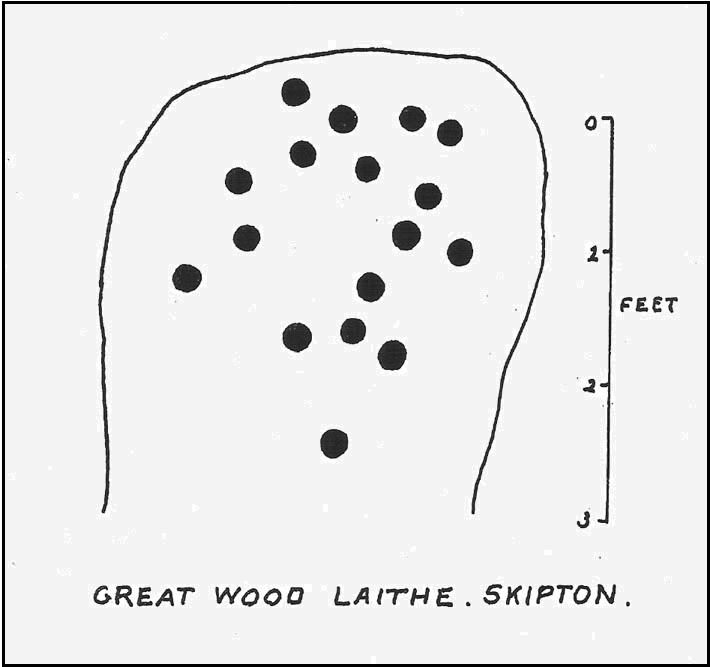
This carving first saw the light of pen-and-paper in the early 1960s, soon after the Yorkshire antiquarian Eric T. Cowling (he of Rombald’s Way fame) was led to the site by his wandering nose and the aid of local people. He sent a letter to the editor of the Bradford archaeology group at the time (a certain Mr Sidney Jackson), which told:
“South-west of the wood which gives its name to the Great Wood Laithe at the western end of Rombalds Moor and overlooking Skipton from the east, is a cup-marked boulder: NGR – SD 99625055. In the middle of the field alongside the wood is an outcrop of rock which has been almost levelled with the adjacent field surface by the dumping of boulders from the surrounding ploughlands.
“The top of the outcrop rises to a dome-shaped projection which bears simple cup-markings. These average two in diameter and total 17 in number. The whole surface of the stone is weathered, and suitable light may reveal more details.”
And, faded though it is, in better lighting conditions it seems there may be more than twenty cup-marks on the rock. Certainly this is what the surveys of Hedges (1986) and Boughey & Vickerman (2003) concluded. There are other carvings close by and, on the hillside immediately above you, the denuded remains of a very impressive prehistoric settlement site known as Horse Close Hill. Well worth having a look at!
References:
Boughey, Keith & Vickerman, E.A., Prehistoric Rock Art of the West Riding, WYAS: Leeds 2003.
Cowling, E.T., “Cup-and Ring Boulders,” in Cartwright Hall Archaeology Group Bulletin, 9:5, May 1964.
Hedges, John (ed.), The Carved Rocks on Rombald’s Moor, WYMCC: Wakefield 1986.
Follow the same directions as to reach the cup-marked Sheriffmuir Carving, which is just a coupla hundred yards away to the southwest. On a clear day you can see this standing stone from the pub by the roadside, a few hundred yards away!
This is alleged to be just one standing stone in a straight line of five once-upright monoliths. Starting at the southwestern end of this row we have the 7ft-long cup-marked Sheriffmuir Carved stone — which certainly looks as if it stood upright in the not-too-distant past — and as we move up the line we pass another that’s been split in half. Another earthfast-looking rock is the next contender, before we reach our famous Wallace Stone, standing upright and proud on this moorland ridge. It’s about 6ft tall and 3ft across at its widest and certainly acts as a marker for the line of stones that allegedly stood upright here. And if we walk just a bit further up we have another big stone laid on the ground which is alleged to be a part of the same alignment.
If it is an authentic megalithic row, it’s not included in either the Thoms’ (1990) two-volume work on the subject, nor Aubrey Burl’s (1996) compendium a few years later. And though the alignment looks good, I’ve found ones just like this in the Pennines where we have just one upright left and then a line of other seemingly prostrate stones running dead straight either side of the singular upright (and have kept mi gob shut about ’em for sensible reasons), so I’m not too sure what to think.
But, alignment aside, the Wallace Stone itself is a damn good standing stone and well worth checking out. It’s highly probable that other prehistoric remains still lurk, undiscovered, amidst these heaths…like the lost stone circle to be found nearby…
Folklore
A slight variation on a theme about this spot: in both accounts the stone was named after the legendary Scottish independence fighter, Sir William Wallace. The folklore tells that he and his fighting clans gathered here in 1297 preceeding the Battle of Stirling Bridge; whilst the variation tells that the stone here was actually erected around that time to commemorate the event. This tale was first narrated by a local story-teller called Blind Harry and was found by local historian A.F. Hutchinson (1893) to be a case of mistaken identity!
References:
Burl, Aubrey, From Carnac to Callanish: The Prehistoric Stone Rows and Avenues of Britain, Ireland and Brittany, Yale University Press 1993.
Heggie, Douglas C., Megalithic science: ancient mathematics and astronomy in north-west Europe, Thames & Hudson: London 1981.
Hutchinson, A.F., “The Standing Stones and other Rude Monuments of Stirling District,” in Transactions of the Stirling Natural History and Antiquarian Society, 1893.
Royal Commission on the Ancient & Historical Monuments of Scotland, Archaeological Sites and Monuments of Stirling District, Central Region, Society of Antiquaries of Scotland 1979.
Thom, A., Thom, A.S. & Burl, Aubrey, Stone Rows and Standing Stones – 2 volumes, B.A.R.: Oxford 1990.
From Dunblane, head up the Glen Road for nearly a mile, turning left up the Sheriffmuir Road and all the wya on till you reach the pub near the T-junction another couple of miles on. OK – get thru the gate and onto the moor, roughly in a straight line with the pub behind you for about 400 yards. You’re damn close! (if you find the nice standing stone known as the Wallace Stone, walk 250 yards southwest from here).
Archaeology & History
Almost nothing has been written of this cup-marked stone, found at the southern end of what’s alleged to be an authentic megalithic stone row alignment, running northeast to southwest — although this alignment isn’t included in either Aubrey Burl’s (1993) or Alexander Thom’s (1990) textbooks dealing with such matters.
Cup-marks highlighted in ice!Cup-marked rock with the Wallace Stone in the distance
When we came here last winter in temperatures of around -6°C (one helluva good day!), curiously only this and the other stones along this “stone row” were actually uncovered on the moorland. Quite bizarre to be honest! Many of the other rocks scattering this small moorland edge were covered in several feet of snow. We were lucky I s’ppose…though I’ve gotta get back up here again shortly and see the site in summertime (midges up mi crotch, cleggs-a-biting – oh such joy!) cos I can’t believe this is the only cup-marked stone hereby.
The rock itself is more than seven-feet long and has at least twenty archetypal cups carved into its slightly-slanting face — although when we visited the stone, several of these were difficult to see and, as the images show, even more difficult to photograph (of the 20 I took of this stone alone, only one was of any value in highlight the cups) . The stone gave the impression that it may have stood upright in the not-too-distant past — which would of course give the notion of this as part of megalithic avenue a considerably more potent status.
Some dood alleged that this potential stone row, with this cup-marked stone at its southwestern end, marked an astronomical alignment — but for the life of me I can’t remember who it was! (it’s my age creeping up on me at last!)
References:
Burl, Aubrey, From Carnac to Callanish: The Prehistoric Stone Rows and Avenues of Britain, Ireland and Brittany, Yale University Press 1993.
Heggie, Douglas C., Megalithic science: ancient mathematics and astronomy in north-west Europe, Thames & Hudson: London 1981.
Thom, A., Thom, A.S. & Burl, Aubrey, Stone Rows and Standing Stones – 2 volumes, B.A.R.: Oxford 1990.