Sacred Well (lost): OS Grid Reference – NA 100 000
Also Known as:
Well of Eternal Youth
Folklore
An old story told in previous centuries by the indigenous folk of Hirta (St. Kilda) described a long-lost well that was thought to be an abode of the little people, known as the Well of Eternal Youth. Not to be confused with the Well of Virtues near the Amazon’s House less than a mile west, the rough whereabouts of this site is cited by J. Sands (1878) in the folklore section of his otherwise historical account on these faraway Atlantic islands. He wrote:
“Once on a time an old fellow, in going up Connagher with a sheep on his back, observed a Well which he had never seen or heard of before. The water looked like cream, and was so tempting, that he knelt down and took a hearty drink. To his surprise all the infirmities of age immediately left him, and all the vigour and activity of youth returned. He laid down the sheep to mark the spot, and ran down the hill to tell his neighbours. But when he came up again neither sheep nor well were to be found, nor has any one been able to find the Tobair na h-oige to this day. Some say that if he had left a small bit of iron at the well—a brog with a tacket in it would have done quite well—the fairies would have been unable to take back their gift.”
Explorations of old maps and texts has failed to show with certainty where this legendary well may have been (the grid-ref is an approximation), but it was reported in Mrs Banks’ Scottish Calendar Customs (1937) to have been “issuing out of the face of a rock on the north-side of the east bay…only accesible by the inhabitants, no stranger daring to climb the steep rock.” Some of us would try!
References:
Banks, M. MacLeod, British Calendar Customs: Scotland – volume 2, Folklore Society: London 1937.
Holy Well? (destroyed): OS Grid Reference – NT 27534 75794
Archaeology & History
Despite this site having a number of albeit brief literary references, from the early 19th century onwards, the history and traditions of this Well are very scant indeed. It figures in various texts that detail the historical ‘Battle of Leith’, but there is little additional information in such tomes. Even local history works pass it by with brevity.
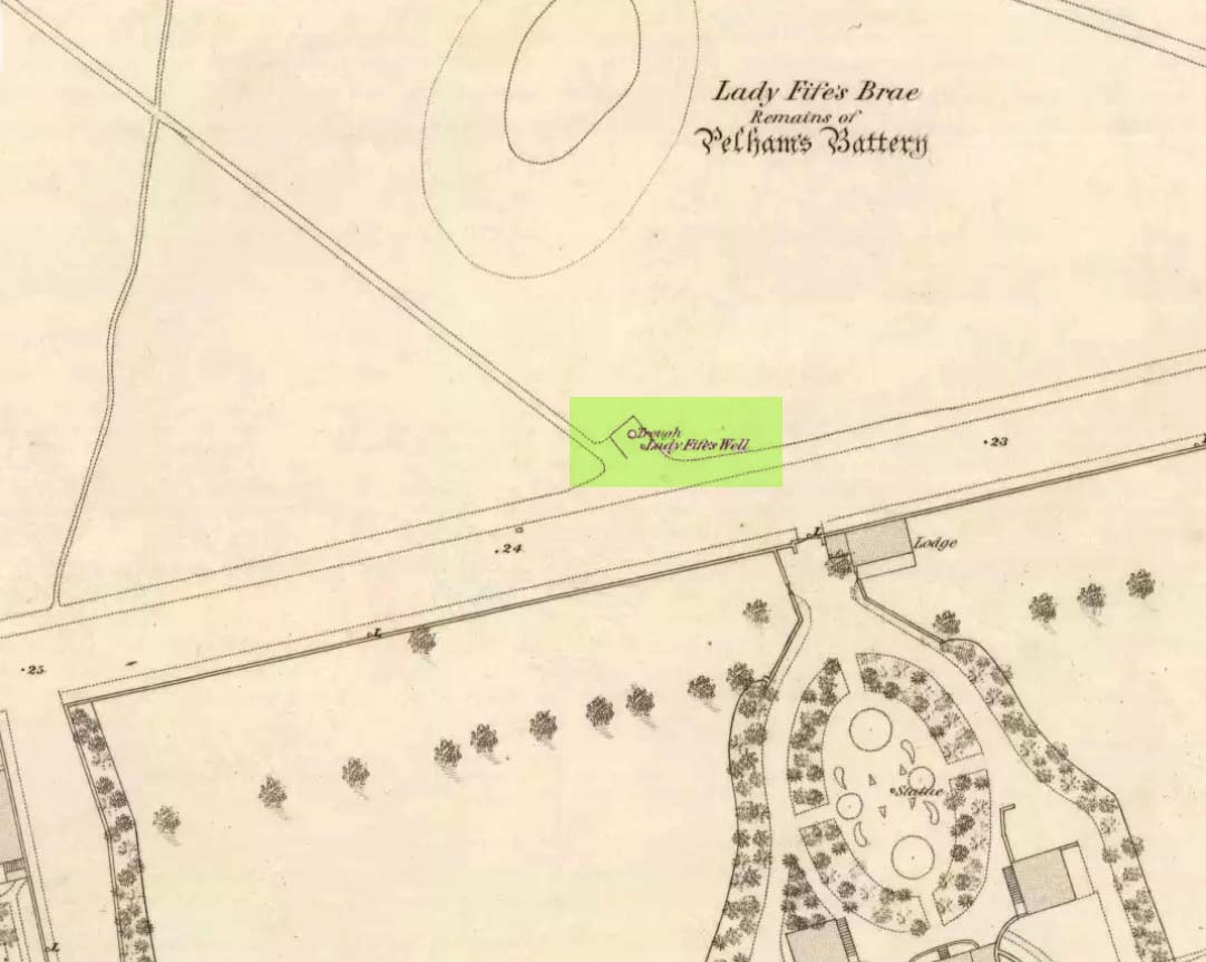
Lady Fifes Well on 1852 mapLady Fifes Well on 1853 map
Its present name derives from the Countess of Fife who, in the 19th century, lived in the nearby mansion of Hermitage House (and who also grafted her name onto the nearby mound of Lady Fife’s Brae); but this title seems to have been grafted onto the earlier ‘Ladie Well’, implying it had a dedication to St. Mary or more probably an earlier heathen female spirit at the waters. Although it is shown on the OS-maps of 1852 and ’53, and described in Grant’s 1883 work as being there in his time, all subsequent maps after this date seem to indicate that it had gone.
All that we know is that the waters ran into a small stone trough and that Lady Fife enjoyed her evenings here, partaking of the waters.
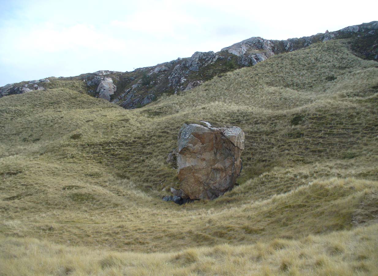
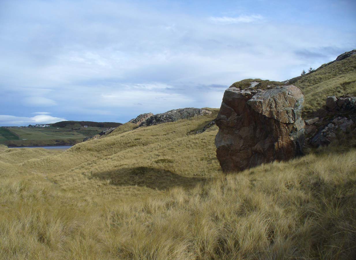
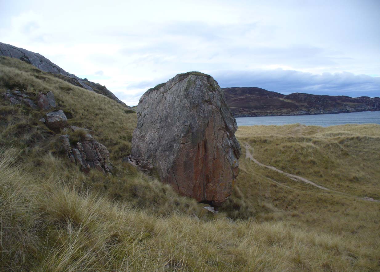
Along the A836 road between Tongue and Bettyhill, turn down towards Skerray at Borgie Bridge for 1.8 miles (2.87km) until you reach the little information sign at the roadside. Walk downhill and cross the little bridge and wander onto the west side of the beach. You’re likely to end up daydreaming… so once you’ve re-focussed, head into the middle of the beach and walk up the steep-ish sand-banks to your right (south). Once at the top, you’ll see a gigantic rock—the Ringstone—nearly as big as a house.
Folklore
This gigantic boulder is part of one of Sutherland’s archaic Creation Myths as they’re known: ancient stories recounted by archaic societies about the nature and origins of the world. Such tales tend to be peopled by giants, gods, huge supernatural creatures, borne of chaos, eggs, darkness and primal oceans. Thankfully we still find some examples of these tales in the northern and northwestern mountainous regions of Britain, as the Church and Industrialism never quite destroyed the hardcore communities—despite what they might like to tell you…
The face of the RingstoneThe Ringstone, gazing east
The following folktale was written by the local headmaster, Alan Temperley (1977), who wrote down many of the oral traditions in Scotland’s far north before they disappeared forever from the tongues of local people (as is sadly happening in these mountains) as they’re slowly, sadly, being erased by the influx of incomers with no connection nor sincere love of old tales and ways. It is typical of stories found other large geological formations from aboriginal Australia, to Skye, to everywhere on Earth where people have settled. Mr Temperley wrote:
“Many years ago there were two giants, the Naver giant from the river at Bettyhill, and the Aird giant from the hill above Skerray. Normally they got on quite well, but one afternoon they became involved in a heated argument about some sheep and cattle, and both grew very angry. The Aird giant was standing on top of the hill above Torrisdale bay with the animals grazing around him, and the Naver giant stormed across the river to the beach below.
“Those are my sheep,” he roared up the hill.
“No they’re not,” the Aird giant said. “At least not all of them.”
“You stole them. You’re a thief!”
“No I didn’t. They came up here themselves. Anyway, you owe me fifty sheep from last year.”
“You’re not only as thief, you’re a liar!” shouted the Naver giant. If you don’t send them down this minute, I’ll come up and see to it myself.”
At this the Aird giant gave a disparaging laugh and made a rude face, and picking up a great boulder flung it down the hill at his friend.
The Naver giant was speechless with fury, and picking the stone up himself, hurled it back up the hillside, making a great hole in the ground.
The Aird giant saw things had gone far enough.
“I’ll send them back if you give me that silver ring you’re always wearing,” he said.
“Never!” roared his friend, his face all red and angry.
“Suit yourself then,” said the Aird giant, and picking the stone up again he tossed it back down the hill.
For long enough the rock kept flying between them, and in time the giant from Naver grew tired, because he was throwing it uphill all the time.
“Will you give me the ring now?” said the Aird giant.
For answer the Naver giant tried one more time to throw the stone up the hill, but it only got halfway, and rolled back down to the shore.
“Come on,” said the giant from Aird, for he wanted to be friends again. “Give me the ring, and I’ll let you have it back later.”
“No!” said the Naver giant from the bottom of the hill. “I’ll never give it to you!” His eyes began to fill with tears.
“Oh, come on, please!” coaxed the Aird giant. “Just for a week.”
“Never, never, never!” shouted the giant from Naver, and pulling the ring from his finger he threw it on the ground and jammed the great boulder down on top of it. Then he sat down on top of the stone and stared out to sea. Every so often he sniffed, and his friend, looking down at his broad back, saw him lift the back of a hand to his eyes.
They never made friends again, and after a long time they both died.
The ring is still buried under the stone, and so far nobody has ever been able to shift it.”
The giant’s face, in profile
When I got back from visiting this immense rock a few weeks ago, a local lady Donna Murray asked me if I’d seen the face of the giant in the rock. I hadn’t—as I was looking to see if the name ‘Ringstone’ related to any possible cup-and-rings on its surface, which it didn’t (although I didn’t clamber onto the top). But in the many photos I took from all angles, Donna pointed out the blatant simulacra of the giant’s face when looking at it from the east.
However, on top of the slope above the Ringstone (not the Aird side), I did find a faint but distinct ‘Ringstone’ carving (without a central cupmark). Whether this ever had any mythic relationship to the tale or the stone, we might never know. The rocky terrain above Aird now needs to be looked at…
References:
Eliade, Mircea, Patterns in Comparative Religion, Sheed & Ward: London 1958.
Long, Charles H., “Cosmogony,” in Eliade, M., Encyclopedia of Religion – volume 4, MacMillan: New York 1987.
MacLagan, David, Creation Myths: Man’s Introduction to the World, Thames & Hudson: London 1977.
Temperley, Alan, Tales of the North Coast, Research Publishing Company: London 1977.
Acknowledgments: Massive thanks again to Donna Murray, for her help and for putting up with me amidst my wanderings up in Torrisdale and district.
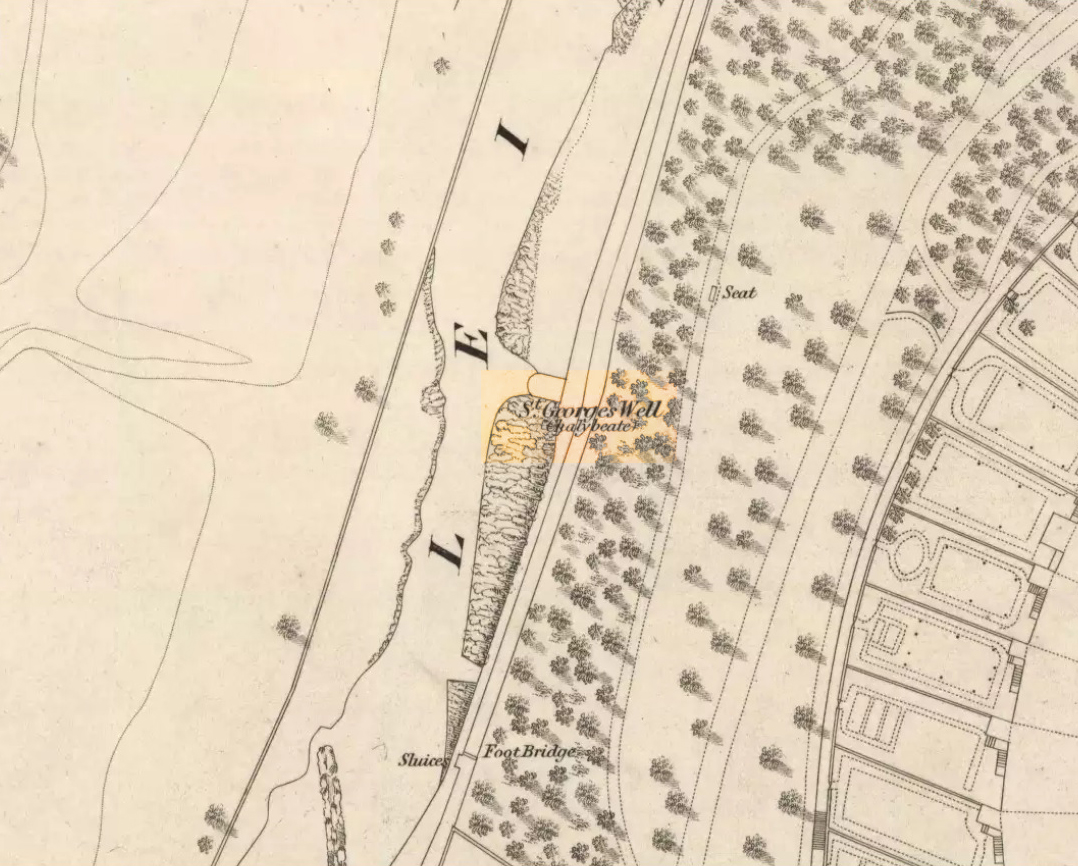
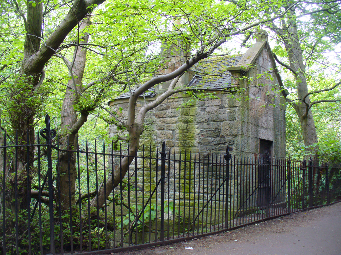
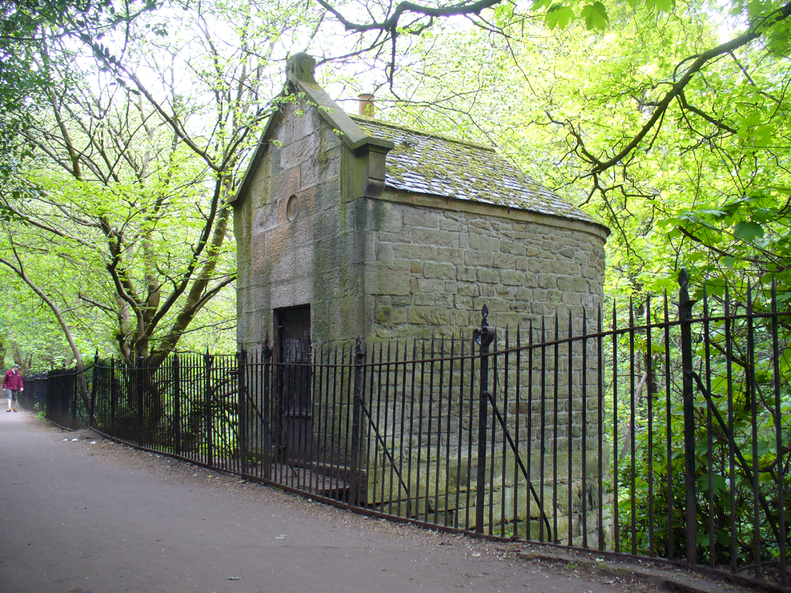
In Edinburgh, get to the west-end of Princes Street (nearest the castle), and where there’s the curious mess of 6 roads nearly skewing into each other, head down Queensferry Street for 450 yards until, just before you go over the bridge, walk down Bells Brae on your left, then turn right down Miller Row where you’ll see the sign to St. Bernard’s Well. St. George’s Well is the small, dilapidated spray-painted building right at the water’s edge 200 yards before St. Bernard’s site.
Archaeology & History
Compared to its companion holy well 200 yards downstream, poor old St. George’s Well is a paltry by comparison, in both historical and literary senses. The site was said to have been “set up in competition with St Bernard’s Well but never achieving its purpose”, wrote Ruth & Frank Morris (1982)—which is more than a little sad. Not on the fact that it failed, but on the fact that some halfwits were using local people’s water supply to make money out of and, when failing, locked up the medicinal spring and deny access to people to this day!
In Mr Grant’s Old & New Edinburgh (1882), the following short narrative was given of the site:
“A plain little circular building was erected in 1810 over (this) spring that existed a little to the westwards of St. Bernard’s, by Mr MacDonald of Stockbridge, who named it St. George Well. The water is said to be the same as the former, but if so, no use has been made of it for many years…”
St George’s Well, looking NSt George’s Well, looking SW
The association to St. George was in fact to commemorate the jubilee of King George III that year. If you visit the place, the run-down little building with its grafitti-door has a small stone engraving etched above it with the date ‘1810’ carved.
As the waters here were found to possess mainly iron, then smaller quantities of sulphur, magnesia and salts, it was designated as a chalybeate well. Its curative properties would be very similar to that of St. Bernard’s Well, which were very good at,
“assisting digestion in the stomach and first passages … cleansing the glandular system, and carrying their noxious contents by their respective emunctories out of the habit, without pain or fatigue; on the contrary, the patient feels himself lightsome and cheerful, and by degrees an increase to his general health, strength and spirits. The waters of St. Bernard’s Well operates for the most part as a strong diuretic. If drunk in a large quantity it becomes gently laxative, and powerfully promotes insensible perspiration. It likewise has a wonderfully exhilarating influence on the faculties of the mind.”
Royal Commission on the Ancient & Historical Monuments, Scotland, Inventory of the Ancient & Historical Monuments of the City of Edinburgh, HMSO: Edinburgh 1951.
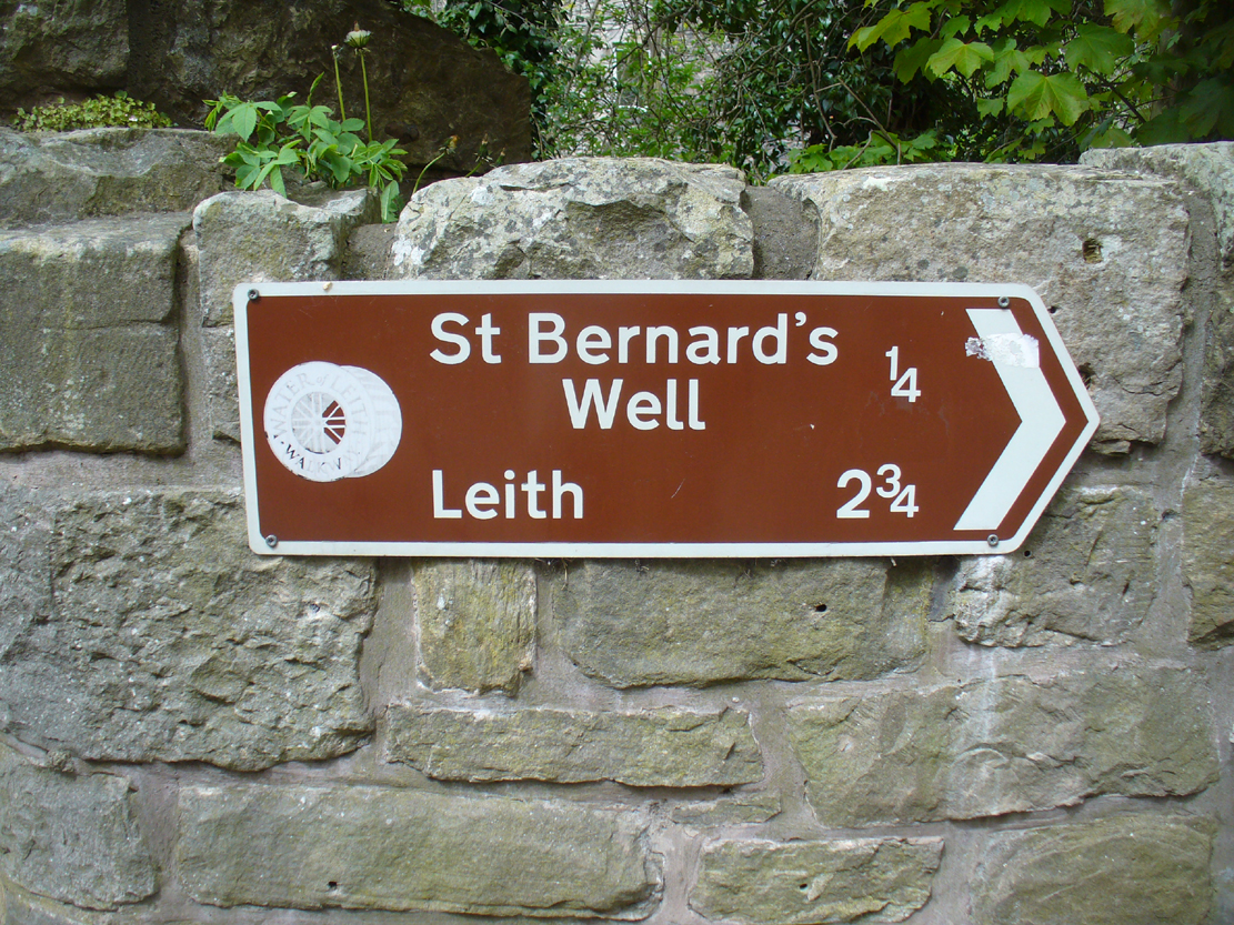
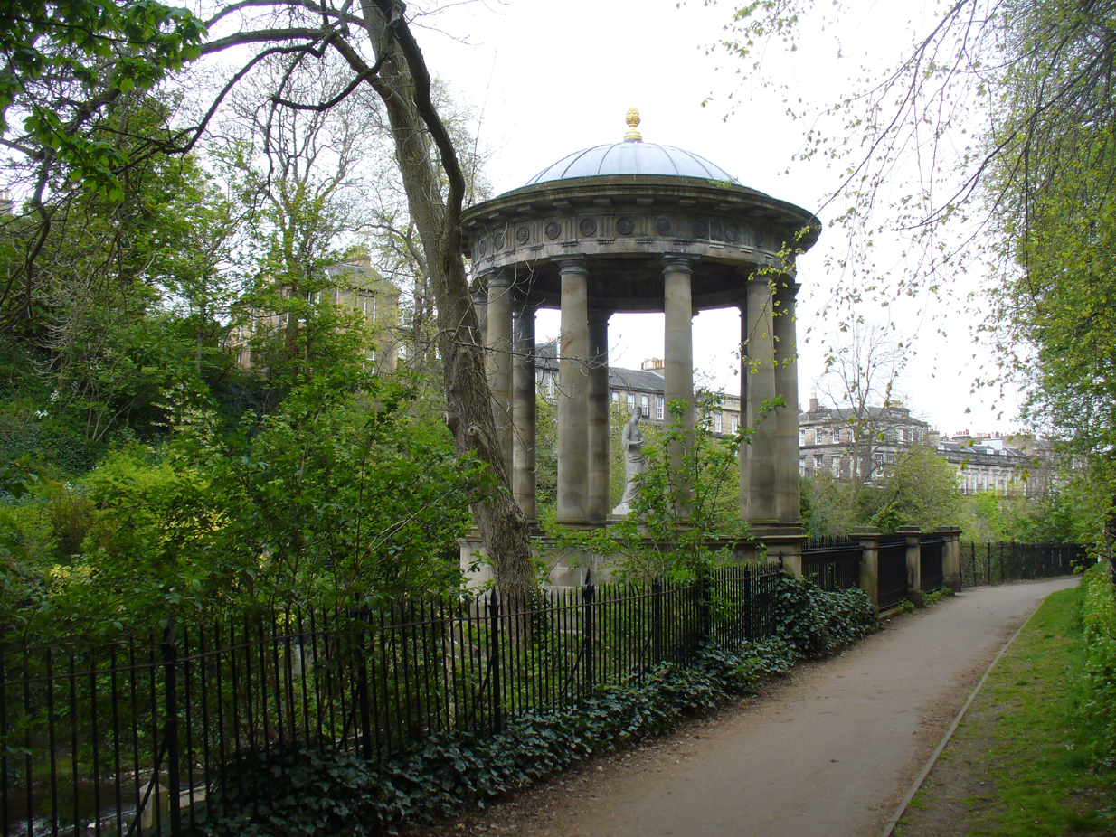
So you’re in Edinburgh. Get to the west-end of Princes Street (nearest the castle), and where there’s the curious mess of 6 roads nearly skewing into each other, head down Queensferry Street for 450 yards until, just before you go over the bridge, walk down Bells Brae on your left, then turn right down Miller Row to the river where you’ll see the sign pointing the way! Walk alongside the river, past St George’s Well for another coupla hundred yards until you reach the large Romanesque domed building right by the riverside on your left. Steps take you down to it.
Archaeology & History
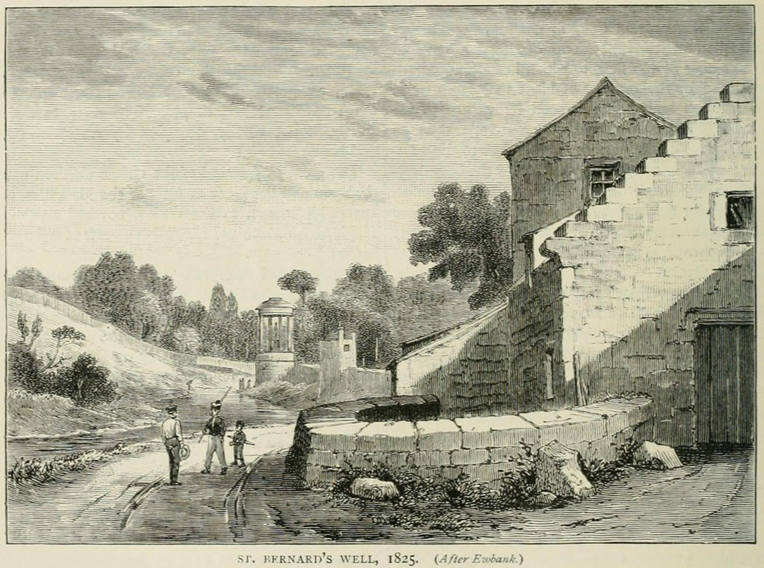
St Bernard’s Well, 1790
When J. Taylor (1790) wrote his singular book on St Bernard’s Well, this sacred site could be seen in landscape that was described as “a wild, romantic, and very pleasant appearance.” How things change! Although the waters of Leith below which the well arises give the region, still, that air of romanticism that Taylor described, on either side of the waters the stone buildings of the Industrialists have grown, denouncing Nature. But to be honest, it’s still a fine place, considering it’s near the middle of a city!
Small spring above the well
In the shrubs and small trees on the slopes just above the architectural edifice that now covers St Bernard’s Well, after rainy days you can see several small springs of water running down the slope and onto the modern path. In earlier centuries there were six of these springs next to each other which ran a short distance down the slope and converged into two, which then ran into a small stone trough. Local people used these fresh waters, not only for basic needs, but for medicinal purposes too.
It seems that the earliest mention of what Stuart Harris (1996) called “this fancy name” of St. Bernard’s Well appeared in an article in The Scots Magazine of September 1760. It clearly shows how the Scottish Freemasons played their part in bringing the waters of this healing well to the fore:
“A mineral well has lately been discovered between the village and the Water of Leith and Stockbridge, about half a mile north of Edinburgh, which is said to be equal in quality to any of the most famous in Britain. To preserve the well from the injury of the weather, and prevent its being overflowed by the Water of Leith, on the banks of which it is situated, a stone covering is to be erected over it. The foundation-stone of this building was laid September 15th (by a deputation from the Earl of Leven, the present Grand Master of Scotland), by Alexander Drummond, brother of Provost Drummond, lately British Consul at Aleppo, and Provincial Grand Master of all the Lodges in Asia and in Europe, out of Britain, holding of the Grand Lodge of Scotland. He was attended by many of the brethren, in their proper clothing and insignia, preceded by a band of music, and the ceremony was performed in the presence of a great number of spectators. It is called St. Bernard’s Well.”
The following year, the poet James Wilson Claudero wrote a poem about the laying of the foundation stone at the well, in which the medicinal virtues of the waters were described. A section of the poem is as follows:
“When heaven propitious to grant his desire
To the utmost extent his heart could require,
For the health of the poor sent this sanative well,
A blessing to all that around it do dwell;
This water so healthful near Edinburgh doth rise
Which not only Bath but Moffat outvies.
Most diseases of nature it quickly doth cure.
“It cleans the intestines and appetite gives
While morbific matter it quite away drives.
Its amazing effects can not be denied,
And drugs are quite useless where it is applied,
So what doctors can’t cure is done by this spring
Preserved till this year of great Drummond’s reign.”
St Bernards Well, looking NSt Bernards Well, looking SW
A few years later in 1786, the construction we see today which now covers the medicinal waters, began to be built. The ‘fashion’ of the rich and wealthy acquiring healing wells used by local people was in vogue at the time and the place became frequented by the usual snooty class of doods who played their social gatherings here. The Scots Magazine gave a brief resumé of what unfolded—intriguingly at Beltane (perhaps the day when its waters were of greatest repute, as is the case at the majority of sacred wells), telling:
“On the 1st of May, the foundation-stone of the mineral well of St Bernard’s, in the vicinity of Edinburgh, was laid in the presence of several gentlemen of the neighbourhood. A plate of metal was sunk into the stone, with the following inscription:
Erected For the benefit of the public at the sole expense of Francis Garden, Esq. of Troop A.D. 1789 Alexander Nasmith, Architect, John Wilson, Builder.
This building is erected in the most picturesque spot in the neighbourhood of Edinburgh, and when finished, from the elegance of the plan, and the excellent quality of the materials, will long be an ornament to the city, and prove a lasting monument of the refined taste, liberality, and public spirit of the honourable founder.”
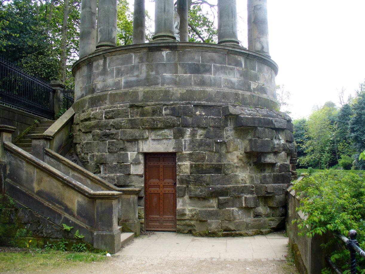
As the reputation of the place spread amongst those who could read and had money, so the day-to-day habits of local people, who kept drinking the waters and collecting them for domestic use, became increasingly frowned upon. Some rich doods bought the land and, thereafter, local people were only allowed to use the well at certain times and in certain ways. I kid you not! This is a familiar tale at a lot of city sites. After the construction of the Romanesque building that still covers the well (based on an ancient temple at Tivoli, Italy, with a statue on top of the goddess of Health, Hygeia) which, to this day, hides the waters inside behind lock and key, the land-owner Lord Gardenstone appointed and paid a ‘keeper of the well’. The ‘keeper—George Murdoch of Stockbridge —had a series of rules to abide by, for which he got paid a tidy sum. Gardenstone wrote to him:
“George — From long experience I entertain a very favourable opinion of your honesty and decent manners. I, therefore, am resolved to make a trial of your capacity to perform properly the duties of a trust which is of a public nature, and requires good temper, patience, and discretion.
“I hereby authorise and appoint you to be Keeper of St Bernard’s Well during pleasure, and you are to observe punctually the following directions and rules, or such other regulations as may be found more expedient and may be hereafter prescribed:
“I. You are to furnish proper glasses and cups for drinking the water.
“II. During the proper season you are to attend the well, at least from six till nine, every morning. During the above period none shall have access to drink or use the water but those who shall pay at the moderate rates subjoined.
“III. Such as choose to subscribe for the season, from the 1st of May to the 1st of October, shall pay down, before they begin to drink, at least five shillings sterling.
“IV. Persons who do not choose to subscribe, but choose at their pleasure to drink the water any time of the morning period, occasionally, shall pay before they begin to drink every morning — for grown persons each one penny, and for children each one halfpenny; or at the rate of sixpence and threepence per week respectively.
“V. For water drawn from the well to be used at a distance, in bottles or other vessels in the mornings, payment must be made at the rate of one halfpenny for every Scots pint.
“VI. No person shall be allowed, on any pretence, to bathe their limbs or sores at, or in sight of, the well during the morning period.
“VII. All persons who are either unable or unwilling to pay as above, shall have free access to the use of the waters from ten to one every forenoon; and those who have once paid may return and use the waters at any time of the day.
“VIII. The keeper shall attend from five to seven o’clock in the afternoon for the service of all who have paid; and after seven for all without distinction.
“IX. Upon a proper certificate from any regular physician, surgeon, or apothecary of Edinburgh, the keeper shall supply poor persons with water at any time prescribed.
“X. The proper and customary method of drinking at mineral waters is, that persons after drinking a glass or cup of water retire immediately and walk about, or take other exercise for an interval of at least five minutes, both as a benefit to themselves, and to make way for other water drinkers. A contrary practice prevails at St Bernard’s, and sometimes a crowd of people continue at the well till they have drunk their quota. Hereafter every person must retire as above, and the keeper must require them to do so, this regulation being very necessary.
“XI. Another irregularity, prejudicial to the credit and use of the waters, has prevailed and must also be corrected, which is that quantities of the water are carried to distant parts in open vessels. All mineral waters should be transported in well- corked bottles or other close vessels. The keeper must strictly adhere to this regulation, and suffer no water to be carried off in open vessels.
“Hints and observations for the better regulation and public use of those waters will be thankfully received by the proprietor.
“Some accounts of the virtues of this mineral water, and of certain remarkable cures performed by the proper use of it, will soon be published by a medical gentleman of character and experience.
“N.B. — The effects of this water when used in making either tea or punch are remarkably agreeable.
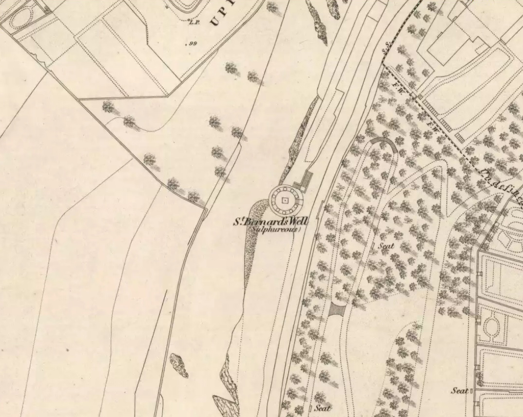
St Bernards Well on the 1819 Kirlands map
This must have caused some friction amongst locals, and no doubt given Mr Murdoch problems at times, as he would be denying the people who were born and bred here access to their drinking and medicinal spring. And so a missive was written on July 4, 1810, which instructed the keeper “to supply the poor with water gratis each day from eleven to twelve o’ clock noon.” Sensible…..
By now, the properties and reputation of the waters were widespread among the elitists and money-addicts. St Bernard’s Well was being compared with the famous healing waters of Bath, Harrogate, Strathpeffer and more. Its cause was encouraged by a series of scientific reports that showed a variety of health-giving minerals in good quantities; and many cases of ‘cures’ were reported by those who drank here. When the local doctor, J. Taylor (1790) opened his treatise on this very issue, he began,
“In the course of my practice, having occasion to visit most of the families in Stockbridge, especially of the poorer sort, I was informed that St Bernard’s Well had been of great benefit to people that resorted to it for various complaints…”
Entrance to the wellSt Bernards Well on 1851 map
Many more cases were to follow. It was the chemical constituents in St. Bernard’s waters that did the trick—although most modern folk would squirm at the very look and whiff of them, as Taylor reported how “the peculiar odour of this water is somewhat nauseous”! That’s because they are primarily sulphurous in nature, along with good traces of iron, magnesia and salts. I’ve drank such waters at some of Yorkshire chalybeates and found them damn invigorating – but most folk won’t touch them with a barge-pole! (chlorinated flouridated tap-water seems most folk’s preference these days) Dr Taylor told how St. Bernard’s Well was very good at,
“assisting digestion in the stomach and first passages … cleansing the glandular system, and carrying their noxious contents by their respective emunctories out of the habit, without pain or fatigue; on the contrary, the patient feels himself lightsome and cheerful, and by degrees an increase to his general health, strength and spirits. The waters of St. Bernard’s Well operates for the most part as a strong diuretic. If drunk in a large quantity it becomes gently laxative, and powerfully promotes insensible perspiration. It likewise has a wonderfully exhilarating influence on the faculties of the mind.”
He thereafter cited a number of cases of people with various ailments whose illnesses were cured by these waters. I recommend a perusal of his work and the other references below for specifics on such matters. The writings on this one sacred site are plentiful indeed, and the bibliographic references are but a morsel of works that describe it.
Folklore
St Bernards Well in 1825
Local tradition ascribed the discovery of the medicinal waters here by three local boys from Heriot, years before the legendary St. Bernard got in on the act; and, despite the wishes of many, St. Bernard of Clairvaux was not in any way related to the legendary Nursie of Blackadder fame (can anyone find a short link so as to educate the unenlightened on this matter?). His hagiography (biography of a saint) tells that his saint’s day was August 20, and his symbols were: a white dog, a chained demon and beehives. Whether any of these symbols related to any indigenous myths at the site is difficult to say.
Mr Cumberland Hill (1887) told the story of how this spring acquired its christian title:
“There is an ancient oral tradition in the district (we read of it also in an old book when we were young) that St Bernard visited Scotland. There are different ways of telling the legend, but the following appears to be the general version. St Bernard, while preaching the second crusade in France and Germany, was advised to go to Scotland as a country rich in faith and fighting men. He was disappointed with his reception at court. In grief, aggravated by ill-health, he withdrew and lived in a cave in the neighbourhood of the spring. There certainly was a cave of considerable dimensions in the steep cliffs to the westward. Its entrance was covered up by the building of the wall that bounds the back of Randolph Crescent, but when it formed part of Lord Moray’s grounds we, and the other boys of Stockbridge, knew that cave well. The saint’s attention was attracted by the number of birds that resorted to the spring. He drank of its healing waters, and, soothed by the sound of the river and the beauty of the scenery — the valley, still very beautiful, must then have been surpassingly fair — his health and serenity of mind returned. He called the inhabitants of the district to the spring, revealed to them its virtues, and, after bestowing upon the people his blessing, he returned to his place of public duty. Christendom concurs that this was the blessing of a good man. He was canonised by the Roman Catholic Church, but as canonisation is growing to be an invidious distinction, we quote Luther’s opinion: “If there ever lived on the earth a God-fearing and holy monk, it was St Bernard of Clairvaux.” We give the tradition as a tradition, not as history, though it is as credible and certainly more creditable than many of the legends of the saints.”
Royal Commission on the Ancient & Historical Monuments, Scotland, Inventory of the Ancient & Historical Monuments of the City of Edinburgh, HMSO: Edinburgh 1951.
The archaeology and traditions ascribed to this ancient tree (exact position unknown) is based on words that were first penned two hundred years ago. It was thankfully recorded with a reasonable description when William Nimmo wrote about the great Sir William Wallace in the second edition of his Stirlingshire (1817) work. Known about in oral tradition by local people, Nimmo told how:
“Torwood was a place where he and his party, when engaged in any expedition in this part of the country, often held their rendezvous, and to which they retreated in the hour of danger. Here is still to be seen an aged oak, well known by the name of Wallace’s Tree; which seems to have been, even then, rotten and hollow within, and is said to have often afforded a lodging to him and a few of his trusty friends. It is supposed to have been one of the largest trees that ever grew in Scotland. It is now almost quite decayed; but, from its ruins, appears to have been of an uncommon size. The remaining stump is no less than eleven or twelve feet in diameter. It stands upon the summit of a small eminence, which is surrounded on all sides by a swamp. A rugged causeway runs from the south through the swamp, and leads up to the tree. Some other vestiges of the stonework are discernible, surrounding the tree in a circular form, and leading to the conjecture that this oak is of a very high antiquity; and that, having been much frequented by Druidical priests, amongst whom the oak was sacred, the causeway had been laid for their approach to it, and the performance, underneath its branches, of religious rites.”
Nimmo may have a point here. Not necessarily of druids (although druidic traditions and reality is known from many old tracts to have continued in many of the hidden places in Scotland), but certainly in relation to the paved track leading to a what may have been a recognised moot-hill, on top of which this great oak once stood. Great trees and ancient meeting places were held in high esteem, not only in the legends of druidism and more established animistic pantheons, but in the recognised pragmatism of local tribal gatherings, in Scotland, Wales, England and in traditional cultures all over the world. (Gomme 1880) The traces of stonework leading to the hill strongly implies an archaeological site in the paving alone; but moreso, as an important site in the traditions of the Scottish people. The fact that these stone ruins were still visible when Nimmo visited the site in the latter-half of the 18th century in the context he describes, implies it may have been the remains of a possible crannog; or a moot hill; or even, with its great oak surmounting, a sacred grove! In my mind, it was probably being used as a gathering place long before William Wallace and his men gathered here…
In 1880, a 3rd edition of Nimmo’s Stirlingshire was published and edited by R. Gillespie. Herein were additional notes about Wallace’s Oak that had been uncovered by Mr Gillespie. Although he’d visited the place,
“Not the smallest vestige…of the Wallace oak remains. Even the ” oldest inhabitant” can say nothing of it save what he has gathered from tradition. Sir Walter Scott, in his Tales of a Grandfather, speaks of having seen some of its roots eighty years ago; and recently we were shown a treasured morsel of the tree in the Chambers’ Institute at Peebles. Wallace, undoubtedly, often chose the solitude of the Torwood as a place of rest for his army, raised and roused to oppose the tyranny of Edward. Here he concealed his numbers and his designs, sallying out suddenly on the enemy’s garrisons, and retreating as suddenly when afraid of being overpowered. While his army lay in these woods, “the oak” was his head-quarters. Within it, the illustrious hero generally slept, the hollow trunk being huge enough to afford shelter both to himself and one or more of his associates.”
When John Gibson (1908) came to write about it, he told that “Wallace’s Oak, which stood on another part of Woodside (low Torwood), has…vanished.” No roots, no lingering trunk—nothing. But although the tree has long since gone, William M. Stirling pointed out in 1817 that,
“A young tree is pointed out in the neighbourhood, as having sprung from an acorn of Wallace’s Oak.”
If and when we can locate the old toll-house of Broomage at Larbert, we get much closer to identifying the exact location of this long lost oak. Then, perhaps, a commemorative plaque should surely be placed there to remind people of their great history, and included on tours of sites relating to Sir William Wallace.
Holy Well (destroyed?): OS Grid Reference – TF 6753 0817
Archaeology & History
Once found in the small woodland known as the High Plantation, this holy well has, seemingly, long since fallen back to Earth. Mary Manning (1994) included it in her survey where she told that in earlier days it could be seen
“in a field which has drainage ditches and cultivation. Here was formerly marshy land draining to the Nar and lying on the south slope of the Nar valley.”
She thought that the title ‘Silver Well’ meant it was a holy site, but others told that it was due to a silver scum that formed on the surface of the waters—and it was a chalybeate (or iron-bearing spring) this is possible.
It was described in Francis White’s (1854) Directory of Norfolk for Shouldham:
“On Mr. Cotton’s estate is a fine chalybeate spring, called Silver Well, which gives rise to a small rivulet which passes through the village. Near this a new spring was discovered about 20 years ago, and both of them possess similar properties to those of Tunbridge Wells.”
This secondary “spring” was another chalybeate well, above which a stone obelisk was erected in 1839.
Folklore
In relation to the object found in the well, Manning (1994) thinks “the objects found could have been pagan votive offerings in a venerated well.” She also told that:
“The well is the subject of a local legend, which takes two forms. One version is that at the Dissolution, treasure from one of the abbeys was hidden in the well. The second says that workmen repairing the well brought up a container/box of silver ware, which was inadvertently dropped back and never recovered. Both tales attribute the silver colour of the well water to the effect of passing over silver treasure.”
A variation on this was noted by folklorist W.B. Gerish (1892) who told that the silver which the workmen dropped back into the well, did so as a result of the devil fighting them over it, and they fled!
References:
Anonymous, Kelly’s Directory of the Counties of Cambridgeshire, Norfolk and Suffolk, Kelly’s Directories Ltd 1925.
Gerish, W.B., Norfolk Folklore Notes, 1892.
Hope, Robert Charles, Legendary Lore of the Holy Wells of England, Elliott Stock: London 1893.
Manning, M., Taking the Waters in Norfolk, NIAS: Norfolk 1994.
White, Francis, Gazetteer and Directory of Norfolk, 1854.
Of all the ancient wells in the city of Glasgow, this has to be one of the most intriguing! Descriptions of it are few and far between, but it is the name of the site which is of interest, to folklorists and occult historians alike. For the word ‘Bogle’ is another term for a ‘boggart’ or goblin of some sort! The well is mentioned in Andy MacGeorge’s (1880) excellent study in his description of ancient wells in the city. Citing notes from the 17th century, amidst many sites,
“Another was Bogle’s Well, in regard to which there is a minute of the town council “that Bogillis Well should be assayed for bringing and convoying the water of the same to the Hie street according to the right the town hes thereof,” and the magistrates are recommended to arrange for having this done “by conduits of led.””
…Obviously in the days when they were clueless about lead-poisoning! The word ‘bogillis’ is the early plural form of the bogle, or bogill (Grant 1941:201). But where exactly was this old well? Are there any other records hiding away to help us locate its original position? It seems to have been one in a cluster of legendary and holy wells in a very small area scattered between Glasgow’s cathedral, down the High Street and to the northern banks of the River Clyde… (the grid-reference given for this site is an approximation)
In a less esoteric fashion, the occult historian Jan Silver suggested that the name of the Well may relate to the family name, ‘Bogle’. This could indeed be the real story behind the well’s name.
Folklore
Traditionally ascribed in the lower counties of England to be an evil malicious sprite, in more northern counties and in Scotland the creature was said by Katherine Briggs (1979) to be a more “virtuous creature”, akin to the helpful brownies or urisks of country lore. This was said to be the case in William Henderson’s (1868) Folklore of the Northern Counties. Whether this well was haunted or the home of a bogle, we do not know as the folklore of this site appears to be lost; so I appeal to any students who might be able to enlighten us further on the place. The Forteans amongst you might have a cluster of ‘hauntings’ hereby, perhaps….
There are two ways into this glen by road. Whichever route you take (from Crieff side, or via the long Dunkeld route), when you hit the flat bottom of it, where the green fields are right by the roadside, walk along till you find the road meets the river’s edge. On the south-side of this small roadside section of the river, you’ll see a single large boulder 10-20 yards away. That’s the spot!
Archaeology & History
Described in some of the archaeology texts as just a ‘cist’, this giant stone is obviously the remains of much more. For a start, as the 1834 drawing illustrates here (coupled with several other early descriptions of the place), other visible antiquarian remains were very much apparent at Ossian’s Stone before a destructive 18th century road-laying operation tore up much of this ancient site. A marauding General Wade of the English establishment was cutting through the Scottish landscape a “military road”, to enable the English to do the usual “civilize the savages”, as they liked to put it. This curious “Giant’s Grave” was very lucky to survive.
Skene’s 1834 sketch, showing surrounding ringOssian’s Stone in the Sma’ Glen
The earliest description of events surrounding the site, as well as the attitude of the Highlanders when they saw the disrespectful English impose their usual disregard, is most insightful. In a series of letters written by a Captain Edward Burt (1759) in the first-half of the 18th century to the english monarch of the period, we read a quite fascinating account which must have been very intriguing to witness first-hand.
General Wade and his band of marauders had reached the Sma’ Glen at the end of Glen Almond and were about to continue the construction of their road. Burt (1759) wrote:
“A small part of the way through this glen having been marked out by two rows of camp colours, placed at a good distance one from another, whereby to describe the line of the intended breadth and regularity of the road by the eye, there happened to lie directly in the way an exceedingly large stone; and, as it had been made a rule from the beginning, to carry on the roads in straight lines as far as the way would permit, not only to give them a better air, but to shorten the passenger’s journey, it was resolved the stone should be removed, if possible, though otherwise the work might have been carried along on either side of it.
“The soldiers, by vast labour, with their levers and jacks, or hand-screws, tumbled it over and over till they got it quite out of the way, although it was of such an enormous size that it might be matter of great wonder how it could ever be removed by human strength and art, especially to such who had never seen an operation of that kind: and, upon their digging a little way into that part of the ground where the centre of the base had stood, there was found a small cavity, about two feet square, which was guarded from the outward earth at the bottom, top, and sides, by square flat stones.
“This hollow contained some ashes, scraps of bones, and half-burnt ends of stalks of heath; which last we concluded to be a small remnant of a funeral pile. Upon the whole, I think there is no room to doubt but it was the urn of some considerable Roman officer, and the best of the kind that could be provided in their military circumstances; and that it was so seems plainly to appear from its vicinity to the Roman camp, the engines that must have been employed to remove that vast piece of a rock, and the unlikeliness it should, or could, have ever been done by the natives of the country. But certainly the design was, to preserve those remains from the injuries of rains and melting snows, and to prevent their being profaned by the sacrilegious hands of those they call Barbarians, for that reproachful name, you know, they gave to the people of almost all nations but their own.
“…As I returned the same way from the Lowlands, I found the officer, with his party of working soldiers, not far from the stone, and asked him what was become of the urn? To this he answered, that he had intended to preserve it in the condition I left it, till the commander-in-chief had seen it, as a curiosity, but that it was not in his power so to do; for soon after the discovery was known to the Highlanders, they assembled from distant parts, and having formed themselves into a body, they carefully gathered up the relics, and marched with them, in solemn procession, to a new place of burial, and there discharged their fire-arms over the grave, as supposing the deceased had been a military officer.
“You will believe the recital of all this ceremony led me to ask the reason of such homage done to the ashes of a person supposed to have been dead almost two thousand years. It did so; and the officer, who was himself a native of the Hills, told me that they (the Highlanders) firmly believe that if a dead body should be known to lie above ground, or be disinterred by malice, or the accidents of torrents of water, &c. and care was not immediately taken to perform to it the proper rites, then there would arise such storms and tempests as would destroy their corn, blow away their huts, and all sorts of other mis-fortunes would follow till that duty was performed. You may here recollect what I told you so long ago, of the great regard the Highlanders have for the remains of their dead…”
Ossian’s Stone in his landscape
We can rest assured that the ‘Roman officer’ idea proclaimed by our early narrator is most probably wrong and that the nature of this site, when seen at ground-level even today and moreso by referencing Skene’s 1834 drawing of the place, above (which shows a more complete low surrounding ring of stones) indicate this to be of prehistoric provenance. Of intrigue to me, is the ritual of the incoming Highlanders, who took the relics onto another place and re-interred them in their own customary manner. We do not know where the Highlanders moved these (probable) prehistoric relics and I can find no supporting folklore to show precisely where they went—but a likely site would be the prehistoric cairn on the mountaintop southwest of here (at NN 8899 3018), or a site that has sometimes been confused with Ossian’s Stone a short distance to the south in the Sma’ Glen, known as the Giant’s Grave (at NN 9050 2956). This latter site would seem more probable.
Anyway…. many years after Edward Burt’s initial Letters defined the site for outsiders, one Thomas Newte (1791) came a-wandering hereby. He found that the account of General Wade’s intrusion was still on the tongues of local people, along with additions of further giant-lore and Fingalian tales, typical of the Creation myths of our early ancestors. In typically depreciative English manner Newte told:
“In that awful part of Glen Almon, already mentioned, where lofty and impending cliffs on either hand make a solemn and almost perpetual gloom, is found Clachan-Of-Fian, or monumental Stone of Ossian. It is of uncommon size, measuring seven feet and an half in length, and five feet in breadth. About fifty years ago, certain soldiers, employed under General Wade in making the Military Road from Stirling to Inverness, through the Highlands, raised the stone by large engines, and discovered under it a coffin full of burntbones. This coffin consisted of four gray stones, which still remain, such as are mentioned in Ossian’s Poems. Ossian’s Stone, with the four gray stones in which his bones are said to have been deposited, are surrounded by a circular dyke, two hundred feet in circumference, and three feet in height. The Military Road passes through its centre.”
Cole’s 1911 plan of stone & surrounding ringOssian Stone by Fred Cole
From hereon, many other writers and travellers came to see this great legendary stone within the depleted remains of its embanked circle—and thankfully it hasn’t been disturbed any further, still being visible to this day. The greatest ‘archaeological’ attention the site has received was from the early pen of great antiquarian Fred Coles (1911). On his journey here, after travelling past a large white stone which was mistakenly named as Ossian’s Stone by the usual contenders, he and his friend reached the right place:
“close to a strip of ground where the river and road almost touch each other, and immediately below the steepest of the crags of Dun More on the eastern side and the debris slopes of Meall Tarsuinn on the west, a most impressive environment, be the stone a prehistoric monument or not! The spot is interesting for itself, apart from all legend; and the remains consist of a mighty monolith…and a narrow grassy mound…to its east, with a few earthfast blocks set edgewise near its eastern extremity. Close to the roadside, but at the same level of 690 feet above the sea, there is a slab-like stone set up, measuring 3 feet in width, 1 foot 3 inches in thickness, and about 2 feet 6 inches in height. A space of 63 feet separates this block…from the huge rhomboidal mass called Ossian’s Stone. Five feet east of the latter is the base of the grassy mound which measures about 12 feet in length, 4 feet in greatest breadth, and 3 feet 10 inches in height. To the north and the south in a slightly curving line are set the six small slabs shown. There seems also to be a vague continuation of this strange alignment in both directions. All over the ground between A and B, are many strangle low parallel ridges of smallish stones having a general direction of nearly north and south. The rest of the ground is grassy, and here and there a little stony. In the plan all the stones are drawn larger than exactly to scale.
“The great stone is 8 feet high and has a basal girth of 27 feet. Several small stones lie near it. Such are the facts as at present to be observed on the ground.”
Section of outlying grass-covered low ring, just visibleGeological cup-marks?
There are two small conjoined cup-marks on top of the stone, but these seem to be geological in nature. The precise nature of the site is difficult to ascertain without excavation; but the Royal Commission lads reckon it to be a prehistoric ‘cist’ or grave in their own analysis, based mainly on the quoted literary texts. The surrounding ‘ring’ of small stones doesn’t seem to have captured their attention too much; but the site needs contextualizing within this damaged circular enclosure, which appears to have been a cairn circle initially, of some sort, with Ossian’s huge stone resting over the grave of one late great ancestral character, probably placed here thousands of years back in the Bronze Age… A truly fascinating place in truly gorgeous landscape.
Folklore
The glen itself has a scattering of giant lore associated with Finn and/or Ossian. A nearby cave was one of the places where this legendary character, and subsequent bards, were said to have spent time.
There are a small number of heavy rocks presently placed on top of Ossian’s Stone. These may be due to the site being used as a “lifting stone”: a sort of rite of passage found at a number of sites in the Perthshire mountains and across the Highlands to indicate a boy’s strength before entering manhood. Not until they have lifted and deposited a very heavy rock onto the boulder can they rightly become chief or leader, etc.
The poet William Wordsworth wrote about Ossian’s Stone, calling it “Glen Almein, or The Narrow Glen”:
In this still place, remote from men,
Sleeps Ossian, in the Narrow Glen;
In this still place, where murmurs on
But one meek streamlet, only one:
He sang of battles, and the breath
Of stormy war, and violent death;
And should, methinks, when all was past,
Have rightfully been laid at last
Where rocks were rudely heaped, and rent
As by a spirit turbulent;
Where sights were rough, and sounds were wild,
And everything unreconciled;
In some complaining, dim retreat,
For fear and melancholy meet;
But this is calm; there cannot be
A more entire tranquillity.
Does then the Bard sleep here indeed?
Or is it but a groundless creed?
What matters it? I blame them not
Whose Fancy in this lonely Spot
Was moved; and in such way expressed
Their notion of its perfect rest.
A convent, even a hermit’s cell,
Would break the silence of this Dell:
It is not quiet, is not ease;
But something deeper far than these:
The separation that is here
Is of the grave; and of austere
Yet happy feelings of the dead:
And, therefore, was it rightly said
That Ossian, last of all his race!
Lies buried in this lonely place.
References:
Anonymous, Tourists Guide to Crieff, Comrie and the Vale of Strathearn, Crieff
1874.
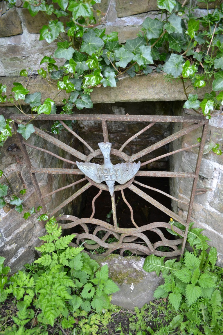
A stone’s throw from Ikea and found off the B600 main road. Travelling to Greasley from Watnall, take first turning on the left after Royal Oak Wood. Travel up Trough Road, past the woods where it is best to park, then walk up Trough Lane and the well can be found on the right hand side, opposite a house called The Springs.
Archaeology & History
I am of the opinion that the ‘holy’ element of this well is a romanticism of the 1800s, but there is a possible record in the ‘The Manor of Bevall in the County of Nottingham’ document, commissioned by the Honourable Dame Elizabeth Capell in 1653. Amongst the records it appears a number of times as:
‘Holy Well Furlong 2 lands bounded with John Richards west and William Hickton east’.
Plaque at the wellFront of the well
A 1724 Capps Survey of Watnall Cantelupe notes that Joseph Richards had some lands lying in a close called the Flatts or Holliwell, which understandably relates to ‘Holy Well’. There is also note of a Holwell Croft field name in the 1500s at Greasley, which again may describe this site or another and such suggests that it derives from O.E. hol, meaning ‘hollow’, a common misconception when identifying prospective holy wells. Jeremy Harte (2008) in his English Holy Wells suggests that those sites called ‘Holy Well’ are pre-Medieval in origin so perhaps this site is one of the most ancient in the county.
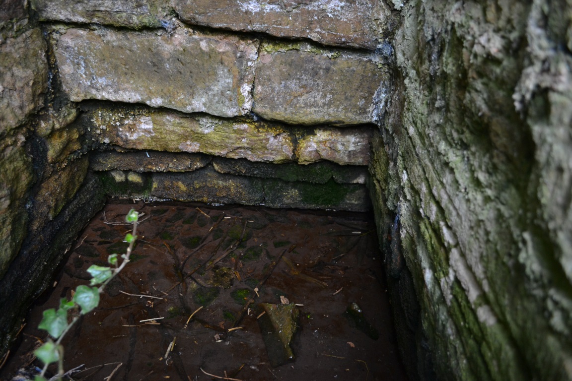
The sacred waters
On my first visit to this site I was told by an elderly man that he was baptised there (or water used from it used for his baptism), before attempting inexplicably in trying to discourage me from finding it (due to his wariness of me I failed to discover the nature of his baptism or of what denomination). According to locals in the lane the plaque and present state of the well dates from the 1980s and was done in partnership with the local council.
The house opposite is called ‘The Springs’ was this name of the well before the ‘present’ name and so it is ‘modern’ holy well per se, although I think the 18th century survey is significant.
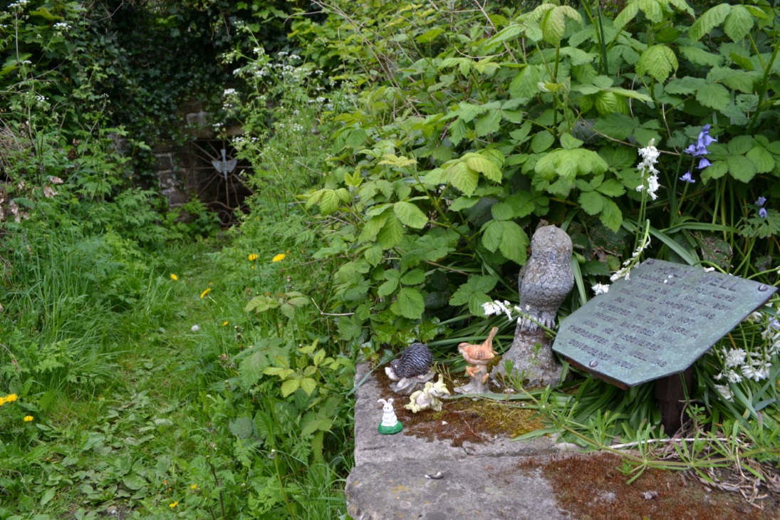
The well itself, is enclosed in a stone recess with a rusty iron gate with a dove affixed on it bearing the legend Holy Well. It is approached by a path walled along both sides which are adorned by a wide range of gnomes and garden ornaments..almost so you could be pixy led!
Folklore
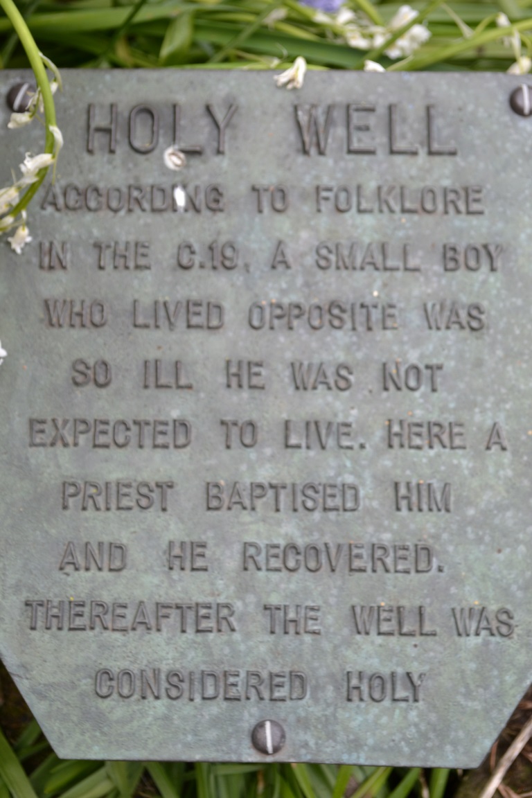
A plaque near the well’s entrance has a local piece of folklore recorded. This relates that a local boy who lived opposite was very ill and bedridden. A local priest called for water to be drawn for the boy from the well. This was done and the boy became well.
Interestingly it’s the only legend of this type—one which records a cure—in all the Nottinghamshire holy wells. It is a shame one cannot find a date or check its provenance, a fact supported by local history author Mr. John Lee. The use of priest is significant. Does the story may indicate the Catholic revival in holy wells in the 19th century? However, the only Catholic associations locally are that of Hilltop at Greasley for there was, and is, only a Methodist chapel in Watnall.
Extracted from Parish, R.B (2008) Holy Wells and healing springs of Nottinghamshire