Oliver’s Mound, Richmond Park, Surrey

Tumulus (destroyed):  OS Grid Reference – TQ 192 735

Also Known as:

  1. Oliver’s Mount

Archaeology & History

Roque’s 1746 map

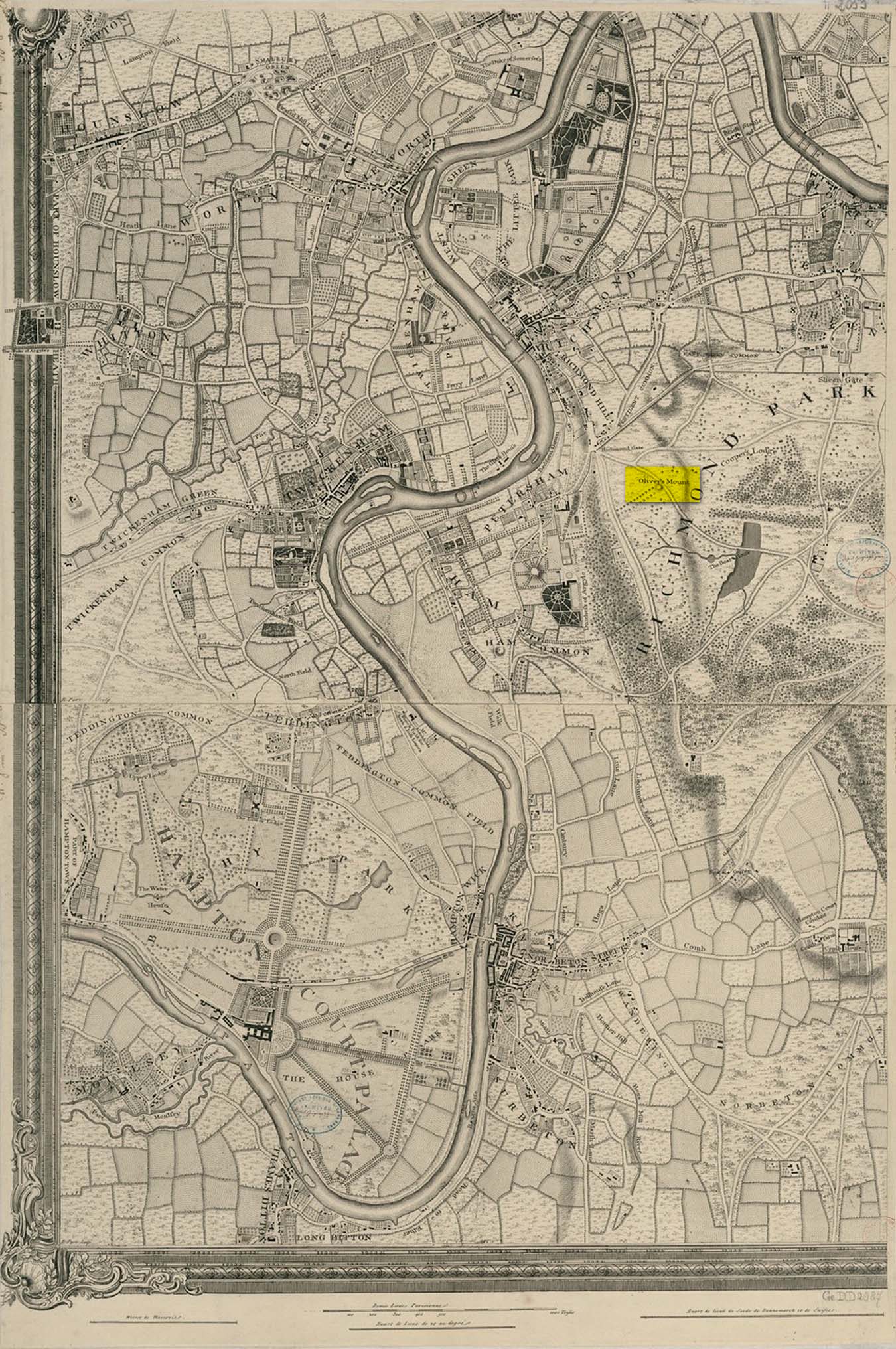
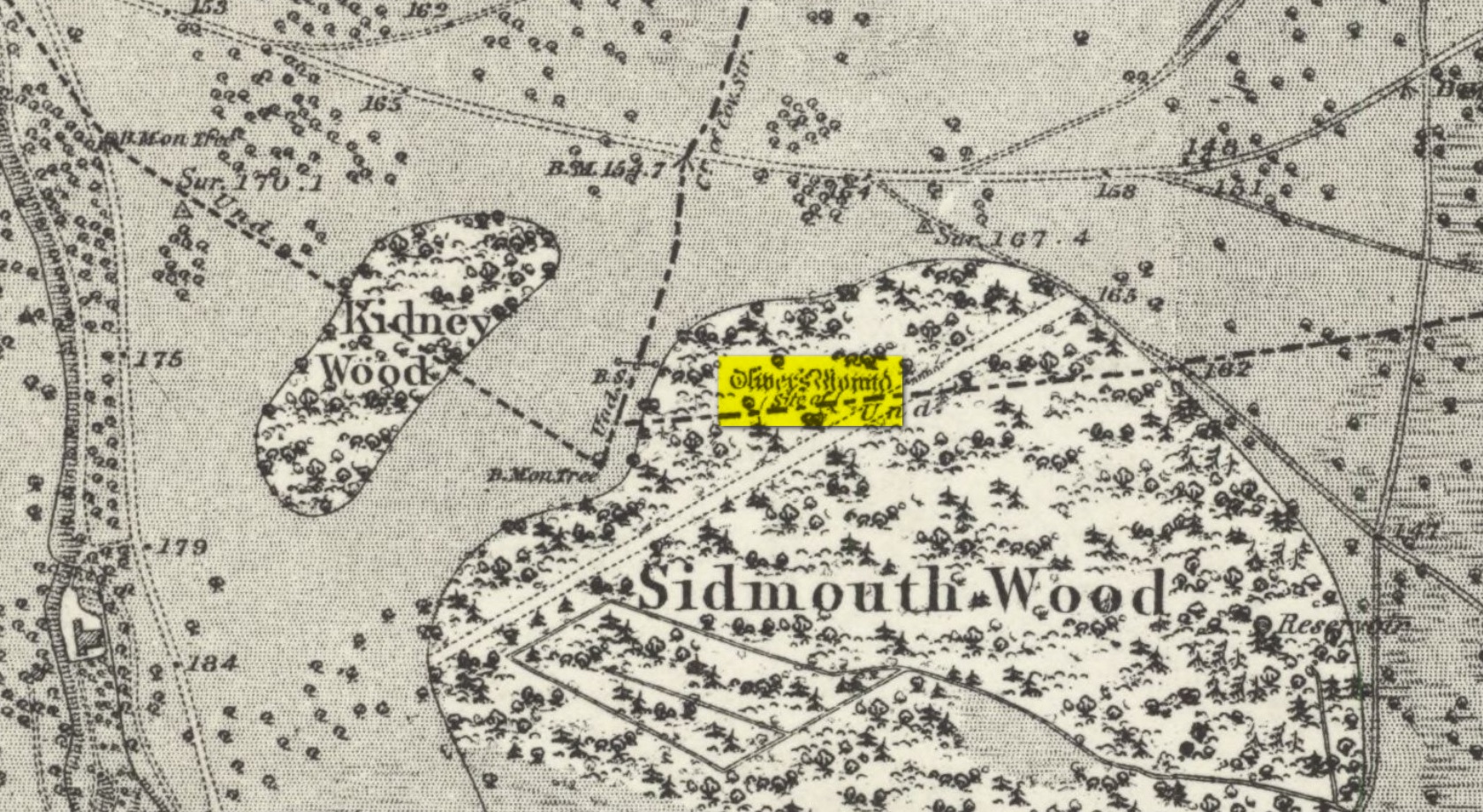
Oliver’s Mound was highlighted as early as 1746 on John Roque’s map of the Country Near Ten Miles Round (London) as still standing.  One hundred and fifty years later, when the Ordnance Survey lads came to map the area, it had gone.  We don’t know exactly when it was demolished, so Historic England (not necessarily a good measure of accuracy) tell us its demise occurred “between 1760 and 1868”, so giving themselves at least some degree of safety!

As we can see in Mr Roque’s old map, an avenue of trees led up to the barrow.  This avenue will have been created when Richmond Park and its gardens were laid out.

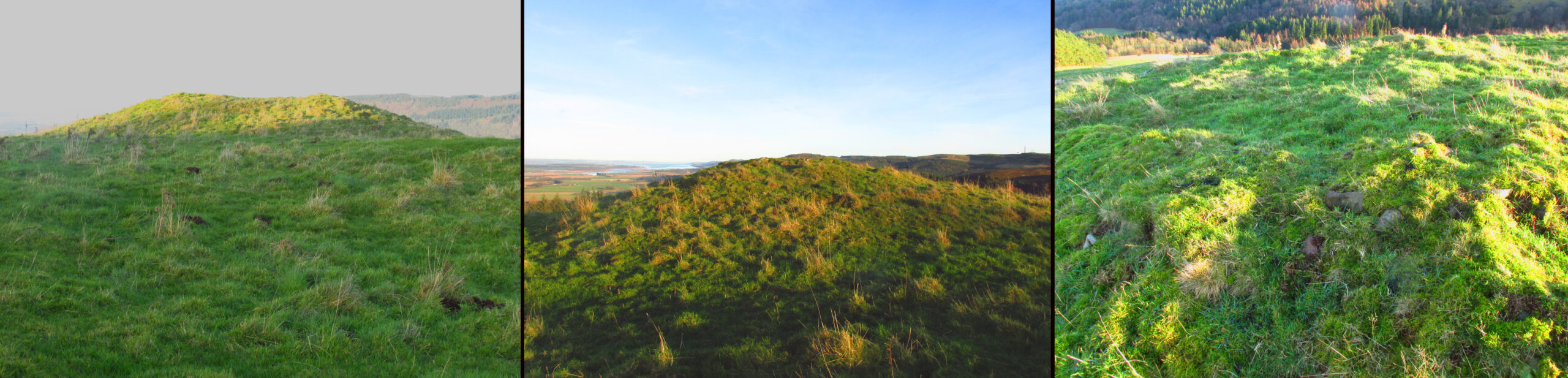
The round barrow was most likely Bronze Age in origin.  The historian and folklorist Walter John (1093) reported that in 1834, three skeletons were found at a  depth of a yard beneath the surface.

Folklore

Site shown on 1873 map

Traditional tells that the name of this barrow comes from when the religious extremist, Oliver Cromwell, and his men, set up camp here.  A slight variant tells that Cromwell stood here to watch a skirmish.

References:

  1. Cundall, H.M., Bygone Richmond, Bodley Head: London, 1925
  2. Grinsell, Leslie V., The Ancient Burial Mounds of England, Metheun: London 1936.
  3. Johnson, Walter, Neolithic Man in North-East Surrey, Elliot Stock: London 1903.
  4. Johnson, Walter, Folk Memory, Clarendon: Oxford 1908.

© Paul BennettThe Northern Antiquarian

St. Fillan’s Tree, Killin, Perthshire

Sacred Tree:  OS Grid Reference – NN 5708 3249

  1. St Fillan’s Ash

Archaeology & History

Long since gone, this great olde ash tree could once be found on the south side of Killin’s Mill building, close to the bridge at the Falls of Dochart.  It was deemed to be ‘sacred’ by local people – just as all trees were, once upon a long time ago.

In John Shearer’s (1883) wonderful book on the ancient ways of the Perthshire people, he described the tree as being adjacent to the earthfast rock known as St. Fillan’s Seat:

“At the side of it grows a large ash tree which is held sacred by the natives as no person will burn any of the branches although fallen to the ground nor destroy them in any manner.  However, there was one who had the hardihood to take one of the branches for a caber to repair his house.  Strange to tell the first fire that was kindled burned it to the ground as a punishment for this impious sacrilege.  Of course no person since has troubled it or taken any of the wood.  The branches that fall lie till they rot.”

The brilliant Killin historian, W.G. Gillies (1938) reported that the tree was still standing until it was “blown down by a gale in 1893″—but it didn’t quite kill it off for good; for in September 1911, C.G. Cash visited Killin and this was one of the many places he looked for and, despite local folk telling him about the more famous St Fillan Stones (still in existence and found at the Mill), he saw the last remnants of this great Ash, telling simply that,

“the mere dead stump of St Fillan’s Ash-tree still stands against the south post of the mill gate.  And quite near it is a young ash, said to be its descendant.  This younger tree has an out-curving branch that was said to have been the gallows-branch in olden days; but it is obviously too young and too weak.”

…So, does anyone know precisely which is the “descendant” of St. Fillan’s Ash and where happens it to be growing?

In Norse myth, the ash tree Yggdrasil was the tree of Odin and was one of the primal ingredients in their Creation myths.  It stood at the centre of the cosmos: an axis mundi no less, linking the many worlds and was the abode of the gods.  Its mythologies are extensive.  In Scotland, the myths of the ash are not so well known, but there’s little doubt that it possessed a sanctity and certainly has many traditions of it own, which are unfortunately outside the remit of this site profile.

References:

  1. Cash, C.G., “Archaeological Gleanings from Killin,” in Proceedings of the Society of Antiquaries of Scotland, volume 46, 1912.
  2. Elders, E A., “Saintly stones in a Perthshire village,” in Country Life, December 1962.
  3. Gillies, William A., In Famed Breadalbane, Munro Press: Perth 1938.
  4. Shearer, John, Antiquities of Strathearn, D. Phillips: Crieff 1883.

© Paul BennettThe Northern Antiquarian

Cow and Calf Stones, East Bierley, West Yorkshire

Crosses / Legendary Rocks (destroyed):  OS Grid Reference – SE 1975 2909

Archaeology & History

Site location at Cross House

Not to be confused with a much more renowned namesake above Ilkley, this was the name given to two old stones that once existed in the middle of the East Bierley hamlet (as it was then) southeast of Bradford.  They were two large boulders next to each other, not far from the early farmstead of Cross House (see map, right) and were described in James Parker’s (1904) historic collage of the area, where he informed us that:

“On the village green (are) the primitive large stones locally called the “Cow and Calf stones,” which used to be in days gone by a Preaching Cross and Market Cross.”

When William Cudworth (1876) described the place nearly thirty years prior, he only mentioned a single cross, telling us:

“There is a lane which has long been called Kirkgate at Birkenshaw, leading up to an ancient cross on the hill.  The fact of this cross being on the hill must have given rise to the name Kirk (church) gate, as there was not, until a few years ago, any church at Birkenshaw.  In a previous paper we had occasion to notice the existence of the cross as an evidence of a pre-church period.”

The meaning behind the name Cow & Calf is unexplained by our respective authors, although Cudworth’s citation of “the cross as an evidence of a pre-church period” is probably not without merit here.  It seems very likely that the animal names of the two large stones—akin to the Cow & Calf Rocks at Ilkley and others of the same name elsewhere in the country—that sat near the top of the hill, probably possessed a creation myth similar to others of the same name.  From this, it seems logical that local folk held the rocks as important, which would have obviously attracted the regressive attention of Church—so they stuck a cross here to christianize the place and in doing so ensured that local people could continue using the place as a meeting place.  This practice (as if you didn’t already know) was widespread.

Although Mr Cudworth seems to give the first real account of the place, field-name records of 1567 listed a ‘Cowrosse’, which may have been the “cross on the Cow” stone.  A.H. Smith (1961) listed the site and suggested the element –rosse may derive from a local dialect word meaning a marsh, but a ‘cow’s marsh‘ seems a little odd.  It is perhaps just as likely that an error was made in the writing of rosse instead of crosse.

References:

  1. Cudworth, William, Round about Bradford, Thomas Brear: Bradford 1876.
  2. Parker, James, Illustrated History from Hipperholme to Tong, Percy Lund: Bradford 1904.
  3. Smith, A.H., The Place-Names of the West Riding of Yorkshire – volume 3, Cambridge University Press 1961.

© Paul BennettThe Northern Antiquarian 

Thistle Brig, Stanley, Perthshire

Legendary Rock: OS Grid Reference – NO 10842 32040

Getting Here

The easiest way to see the site is to stop at the car park at Craighall on the B9099 south of Stanley, and follow the path to the river.  The remains of the Brig will be seen on the other side of the Tay from the riverside walk.

Archaeology & History

The Thistle Brig was described in the nineteenth century Ordnance Survey Name Book as:-

‘A remarkable spot in the River Tay, when the breadth of the river becomes suddenly narrow by the protrusion of a bed of trap rock which crosses it at this place.’

Thistle Brig & the quarries for its hard stone on the 1901 25 in OS-map

According to local historian Alexander Scott, the Thistle Brig formed a convenient place to ford the Tay until  much of it was blasted away by explosives some time in the mid-nineteenth century in order to improve the flow of the river.  Old maps imply that an actual bridge may have spanned the Tay hereabouts at some time in the past.  The seemingly little known folklore of this site relates to an invasion by the Danes in the early mediaeval period. Elsewhere there are similar stories, so the truth or otherwise depends on where you are in Scotland, but this one may have more validity as the tale seems to give its name to the place!

The name ‘Thistle Bridge’ has been applied on old postcards to a stone footbridge over a side channel or lade between the road and the River Tay to the south of the Brig, and is not the subject of this profile.

The remains of the Thistle Brig – a hard basalt dyke on the east bank of the River Tay

Folklore

Alexander Scott, writing of the Brig:-

“…tradition holds that here the thistle received the distinction  of becoming the national emblem of Scotland.  In one of the many invasions the country suffered from foreign armies, the Danes, on one occasion, having landed on the east coast sacked the town of Montrose and continued on their march across the country, burning and pillaging as they went.  While crossing the Tay at this ford at night, the incident occurred of one of the leading soldiers arriving on the opposite side suddenly coming in contact with a thistle with his bare leg, which caused him to emit a shreik of pain.

“The noise was heard by the Scots, who had been encamped nearby, and the alarm thus given was the means of securing a victory over their enemies. The thistle was thereafter honoured as the national badge.”

Reference:

  1. Scott, Alexander, St Martins and Cambusmichael, A Parochial Retrospect, Munro & Scott 1911.

Link:

  1. Ordnance Survey Name Book

© Paul T Hornby 2021

Blind Well, Sutton-in-Holderness, East Yorkshire

Healing Well:  OS Grid Reference – TA 1204 3306

Archaeology & History

Site of well on 1855 map

We don’t know for certain the precise whereabouts of this long lost healing well, but it would seem to be the one highlighted here (right) on the 1855 OS-map.  However, I think it equally possible that the small unnamed building, roughly halfway between the highlighted ‘Well’ and Spring Cottage, where the walling meets, could be the site in question.  It’s one or the other!

Folklore

When Thomas Blashill (1896) wrote of the Blind Well in his standard history work of the area, memory of it was already falling away.  In discussing where local people could wash and look after their health, he told that

“There was one place in the parish where washing seems to have been practised as a curative measure.  Down in the East Field, near to Spring Cottage Farm, was the Blindwell, to which the people had access. If they used its waters freely when suffering from sore eyes, their faith would probably be rewarded.”

References:

  1. Blashill, Thomas, Sutton-in-Holderness, William Andrews: Hull 1896.

© Paul BennettThe Northern Antiquarian

St Everilda’s Well, Everingham, East Yorkshire

Holy Well (destroyed):  OS Grid Reference – SE 80528 42531

Also Known as:

  1. St Everildis Well

Archaeology & History

Shown on the 1855 Ordnance Survey map as a ‘pump’, in the grounds of Everingham Priory, the ‘seat’ of the lord of the manor, it was in an enclosure formerly open to the people of the village. It was filled in prior to 1923. The water was described as ‘abundant and excellent.’ Graeme Chapman, in his Yorkshire Holy Wells website states:

‘A few metres to the south of the site of the well the modern OS map marks the start of a stream (SE 8055 4250) which could be the original source of the Holy well’s water.’ 

The well shown on the 1855 6″ OS Map.

The present writer has not been able to verify this from the materials available to him.

Everilda, also known as Everild and Averil, is recorded in the York Breviary, printed in 1493. She was a mid Yorkshire Saint who died around 700 CE.  According to this source she was of a noble Wessex family who went to Yorkshire with companions Bega and Wulfreda, settling on land called Bishop’s Farm, an estate of the Bishop of York, St Wilfrid , which he gave to them, the place being then called Everildisham. There they established a nunnery, of which all trace is now lost. Her Saint’s day is July 9th. The name of St Everilda has been changed to ‘Emeldis’ in the dedication of the church at Everingham. Some historians claim the village is not named after her, but as a derivation of ‘ham of Eofor’s people’. The only other church known to be dedicated to her is at Nether Poppleton, some 17 miles north west of Everingham.

Folklore

The water of the village and the mothers of Everingham are said to have been blessed by St Everilda, and the Reverend Smith wrote that over a fifty year period, no mother had died in childbirth.

References:

  1. Farmer, David, The Oxford Dictionary of Saints, Oxford University Press, Oxford, 1987
  2. Raine, James, The Dedications of the Yorkshire Churches, The Yorkshire Archaeological and Topographical Journal, Vol II, 1873
  3. Salisbury, Matthew Cheung, The Use of York: Characteristics of the Medieval Liturgical Office in York, Borthwick Institute, York, 2008
  4. Smith, Rev William, Ancient Springs & Streams of the East Riding of Yorkshire, A.Brown & Sons, London, Hull & York, 1923
  5. Stanton, Richard, A Menology of England & Wales.., Burns and Oates, London, 1887

Link:

  1. St Everilda’s Well on Yorkshire’s Holy Wells

© Paul T Hornby 2021

High Cross, Aberford, West Yorkshire

Cross (destroyed):  OS Grid Reference – SE 433 390

Archaeology & History

Mentioned only in passing in the Becca and Aberford Enclosure Act of 1825, all remains of this site have gone.  It was subsequently referred to by Edmund Bogg (1904) in his journey through Elmet as previously standing where the Roman road veered off to the northeast from the “new road”, as it was then.  Bogg’s brief description told that from Nut Hill,

“A little distance south, where the old and new roads part, formerly stood a cross; Highcross Cottage keeps its memory green.”

References:

  1. Bogg, Edmund, The Old Kingdom of Elmet, James Miles: Leeds 1904.

© Paul BennettThe Northern Antiquarian 

Holy Well, Halifax, West Yorkshire

Holy Well (destroyed):  OS Grid-Reference – SE 100 254

Archaeology & History

This sacred site seems to have been destroyed sometime at the end of the 19th century.  It was located on the great slopes heading up to Beacon Hill.  In 1787, a property survey showed six houses here called Holy Well Cottages and on the 1852 OS-map a “Well” is highlighted at the bend in the pathway of the Old Bank as you’re going uphill, which is the place in question.  On my last visit here about thirty years ago, its position was preserved under a large manhole. 

References:

  1. Heginbottom, J.A., “Early Christian Sites in Calderdale”, in Proceedings Halifax Antiquarian Society 1988.

© Paul BennettThe Northern Antiquarian

St John’s Well, Dunrobin, Golspie, Sutherland

Holy Well:  OS Grid Reference – NC 8505 0081

St Johns Well, 1879 map

Archaeology & History

Very little has been written of this site due to the fact that little seems to known about it.  A few of the usual ‘official’ on-line catalogues mention it but information on the site is truly scant.  It is shown on the earliest Ordnance Survey map of the region and the same cartographers describe it in the Ordnance Name Book (1873), saying briefly how St John’s Well,

“Applied to a very deep pump well situated in the court of the ancient portion of “Dunrobin Castle”.  No information respecting the dedication or origin of this name can be obtained in the District.”

But an earlier reference than this is cited in Fraser’s (1892) work, telling us that,

“In the midst of the court within the castle there is one of the deepest draw-wells in Scotland, all lined with ashlar-work, which was built and finished before the house was begun.  The well was known as that of St. John.  In the year 1512 sasine (i.e. delivery of feudal property) of the earldom and castle was taken at the well.  At other times sasine was taken at the castle, at its gates, or near the well.”

Subsequent to this, we read in Cumming’s (1897) definitive folklore work of the region how,

“(it) looks as if there had been a chapel of St. John on Drumrabyn.  In that case it may have been one dependent upon Kileain (=Kirk of John) on Loch Brora, which was only ½ a mile further than Kilmalin.”

Having not visited the castle, I’m unsure whether or not the well can still be seen.  Does anyone know…?

References:

  1. Cumming, Anna & Bella et al, Golspie – Contributions to its Folklore, David Nutt: London 1897.
  2. Fraser, William, The Sutherland Book – volume 1, Edinburgh 1892.

Acknowledgements:  Big thanks for use of the 1st edition OS-map in this site profile, Reproduced with the kind permission of the National Library of Scotland

© Paul BennettThe Northern Antiquarian

Edmund’s Grave, Dron, Perthshire

Cairn: OS Grid Reference – NO 14676 14519

Also Known as:

  1. Balmanno Hill
  2. Canmore ID 28087

Getting Here

Take the Glenfarg road out of Bridge of Earn, cross the motorway and park at the layby past the bend. Go through the gate opposite and follow the track up to the telecoms mast, you can’t miss it..

Archaeology & History

Shown on the 1866 OS Map

Visible from the lowlands below, it is described in the official listing as a cairn of prehistoric date, a funerary monument dating to the late neolithic to early Bronze Age. It is a broadly round stony mound, partially overgrown with turf on the north eastern (mid-summer sunrise) slope of Balmanno Hill, where it has extensive views over the surrounding country.  It is 1.8m (6′) high, 17m (56′) across on the N-S axis and 16m (52′ ) on the E-W axis.

The top of the cairn has a depression in it: possibly the result of treasure-seeking long ago, but there is no evidence of any burial cist.

So who was ‘Edmund’?  Was this a place of heathen ritual Christianised with the designation of St Edmund during the Anglo-Saxon incursions of the early middle ages, or the name of a local landowner?  It is lost to history. The name ‘Balmanno’ can be interpreted as ‘Place of the Big Man’ – so have we an echo of a lost giant legend here in an area of Scotland where such legends abound, and long pre-date the construction of the cairn?  Did later people name their local mythic giant ‘Edmund’?

An alternative meaning of ‘Balmanno’ is given by David Dow in the Old Statistical Account – the ‘Town of the Monk’.

Left – View from South, Centre – View from west looking towards Firth of Tay, Right – The disturbed summit.
© Paul T. Hornby, 2020

Folklore

The Ordnance Survey inspectors of the early 1860s were told that the cairn is where one of the Roman Generals of Agricola’s time was buried.

References:

  1. Dow, Rev. David, The Statistical Account of Scotland 1791-99, Vol. XI, EP Publishing, Wakefield, 1976
  2. Jamieson,John, An Etymological Dictionary of the Scottish Language, Vols.I & III, Alexander Gardner, Paisley, 1880
  3. Ordnance Survey Name Books Perthshire, Volume 21 OS1/25/21/11, 1859-62
  4. http://portal.historicenvironment.scot/designation/SM9458

© Paul T Hornby 2020