Tumulus (possible): OS Grid Reference – TQ 2856 7555
Also Known as:
Mount Nod
Archaeology & History
Located on the old boundary line between Clapham and Battersea, what might have been a forgotten tumulus, whose memory was thankfully preserved by the renowned folklorist and historian Walter Johnson (1903), was described in his work on prehistoric Surrey. He seemed to think it serious enough to add to his survey, where he told us that,
“there still exists, near Cedars Road, Clapham, what may possibly be a round barrow. It is in the garden of a house opposite St. Saviour’s Church, and is visible to anyone passing along the old, narrow passage called Wix’s Lane. Mr. J.W. Grover, who brought the matter before the Archaeological Association in 1884, had been struck by the discovery that old maps marked the spot ‘Mount Nod Fields.’ …The mound must originally have been 70 or 80 feet across, but had been tampered with on one side for the construction of an ice-house. Mr. Grover suggested that the mound may be of Celtic date. To us, the height—some 12 feet or more—together with marked signs of reconstruction at a comparatively modern date, indicate the necessity of withholding judgment. The original tumulus may simply have been increased in height, but…digging alone could settle the question.”
Local historian Michael Green (2010) has found that there were prehistoric tombs on Clapham Common only 500 yards away, so this one along Cedar Road was not in isolation. Is the site named on the boundary perambulation records? Has it been explored since Johnson wrote about it and, if so, has its veracity as a prehistoric tomb been ascertained, or is it merely the remains of some post-medieval creation?
Healing Wells (destroyed): OS Grid Reference – TQ 3094 7889
Also Known as:
Lambeth Spa
Near Well and Far Well
Archaeology & History
This once famous healing or spa well has long gone. It was located where the buildings that now constitute 104-105 Lambeth Walk presently stand: an area which the great London historian William Thornbury (1878) told was already “a favourite resort of Londoners, and celebrated for the variety of sweet-smelling flowers and medicinal herbs growing there,” complementing the healing waters before and during the spa craze. The great herbalist John Gerard did his collections here.
I can find no information regarding its early use by our peasant ancestors, so its written history simply begins when it had been appropriated by those well-to-do up-market types who took this medicinal spring for their commercial gain in the early days of the trendy spas. Supplied by two separate springs known as the Nearer and Farther Wells respectively, the Well House built here was “formally opened in April 1696” and subsequently had almost daily accompaniments of music, including French and country dancing! But as the popularity of the Lambeth Spa increased, so did its problems. Phyllis Hembry (1990) told that by July 1715, one visitor to the spa,
“was so depressed to find that the many people there were mostly rakes, whores and drunkards, idlers such as Guard officers, or young pleasure-seeker like attorneys’ clerks, mingling with loose women of the the meanest sort. The Lambeth Wells also became a public nuisance, so a dancing license was refused in 1755.”
The so-called Great Room which had been the place of great occasions by spa users ended up being the meeting place “for Methodist meetings.” Oh how the winter nights must have flown by…..
There was a decided improvement in the years that followed and social events at the spa increased again. It became what Thornbury said “was another place of amusement.” The Lambeth Wells, he wrote,
“were held for a time in high repute, on account of their mineral waters, which were advertised as to be sold, according to John Timbs, at “a penny a quart, the same price paid by St. Thomas’s Hospital.” About 1750, we learn from the same authority, there was a musical society held here, and lectures, with experiments in natural philosophy, were delivered by Dr. Erasmus King and others. Malcolm tells us that the Wells opened for the season regularly on Easter Monday, being closed during the winter. They had “public days” on Mondays, Thursdays, and Saturdays, with “music from seven in the morning till sunset; on other days till two!” The price of admission was threepence. The water was sold at a penny a quart to the “quality” and to those who could pay for it; being given gratis to the poor. We incidentally learn that there were grand gala and dancing days here in 1747 and 1752, when “a penny wedding, in the Scotch manner, was celebrated for the benefit of a young couple.”
By this time, a rival St. George’s Spa of had been created a short distance away on the parish boundary and with it, the popularity and attendance at Lambeth Wells began to decline. By the end of the 18th century, the rot had truly set in and its days were finally numbered.
As for the medicinal properties of these wells, little seems to have been recorded. Aside from repeating the common description of them being mineral waters, William Addison (1951) simply added that they were also purgative.
References:
Addison, William, English Spas, Batsford: London 1951.
Crosses / Legendary Rocks (destroyed): OS Grid Reference – SE 1975 2909
Archaeology & History
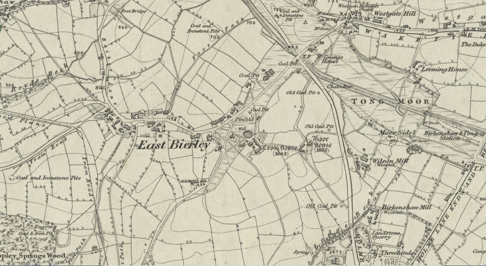
Site location at Cross House
Not to be confused with a much more renowned namesake above Ilkley, this was the name given to two old stones that once existed in the middle of the East Bierley hamlet (as it was then) southeast of Bradford. They were two large boulders next to each other, not far from the early farmstead of Cross House (see map, right) and were described in James Parker’s (1904) historic collage of the area, where he informed us that:
“On the village green (are) the primitive large stones locally called the “Cow and Calf stones,” which used to be in days gone by a Preaching Cross and Market Cross.”
When William Cudworth (1876) described the place nearly thirty years prior, he only mentioned a single cross, telling us:
“There is a lane which has long been called Kirkgate at Birkenshaw, leading up to an ancient cross on the hill. The fact of this cross being on the hill must have given rise to the name Kirk (church) gate, as there was not, until a few years ago, any church at Birkenshaw. In a previous paper we had occasion to notice the existence of the cross as an evidence of a pre-church period.”
The meaning behind the name Cow & Calf is unexplained by our respective authors, although Cudworth’s citation of “the cross as an evidence of a pre-church period” is probably not without merit here. It seems very likely that the animal names of the two large stones—akin to the Cow & Calf Rocks at Ilkley and others of the same name elsewhere in the country—that sat near the top of the hill, probably possessed a creation myth similar to others of the same name. From this, it seems logical that local folk held the rocks as important, which would have obviously attracted the regressive attention of Church—so they stuck a cross here to christianize the place and in doing so ensured that local people could continue using the place as a meeting place. This practice (as if you didn’t already know) was widespread.
Although Mr Cudworth seems to give the first real account of the place, field-name records of 1567 listed a ‘Cowrosse’, which may have been the “cross on the Cow” stone. A.H. Smith (1961) listed the site and suggested the element –rosse may derive from a local dialect word meaning a marsh, but a ‘cow’s marsh‘ seems a little odd. It is perhaps just as likely that an error was made in the writing of rosse instead of crosse.
References:
Cudworth, William, Round about Bradford, Thomas Brear: Bradford 1876.
Parker, James, Illustrated History from Hipperholme to Tong, Percy Lund: Bradford 1904.
Smith, A.H., The Place-Names of the West Riding of Yorkshire – volume 3, Cambridge University Press 1961.
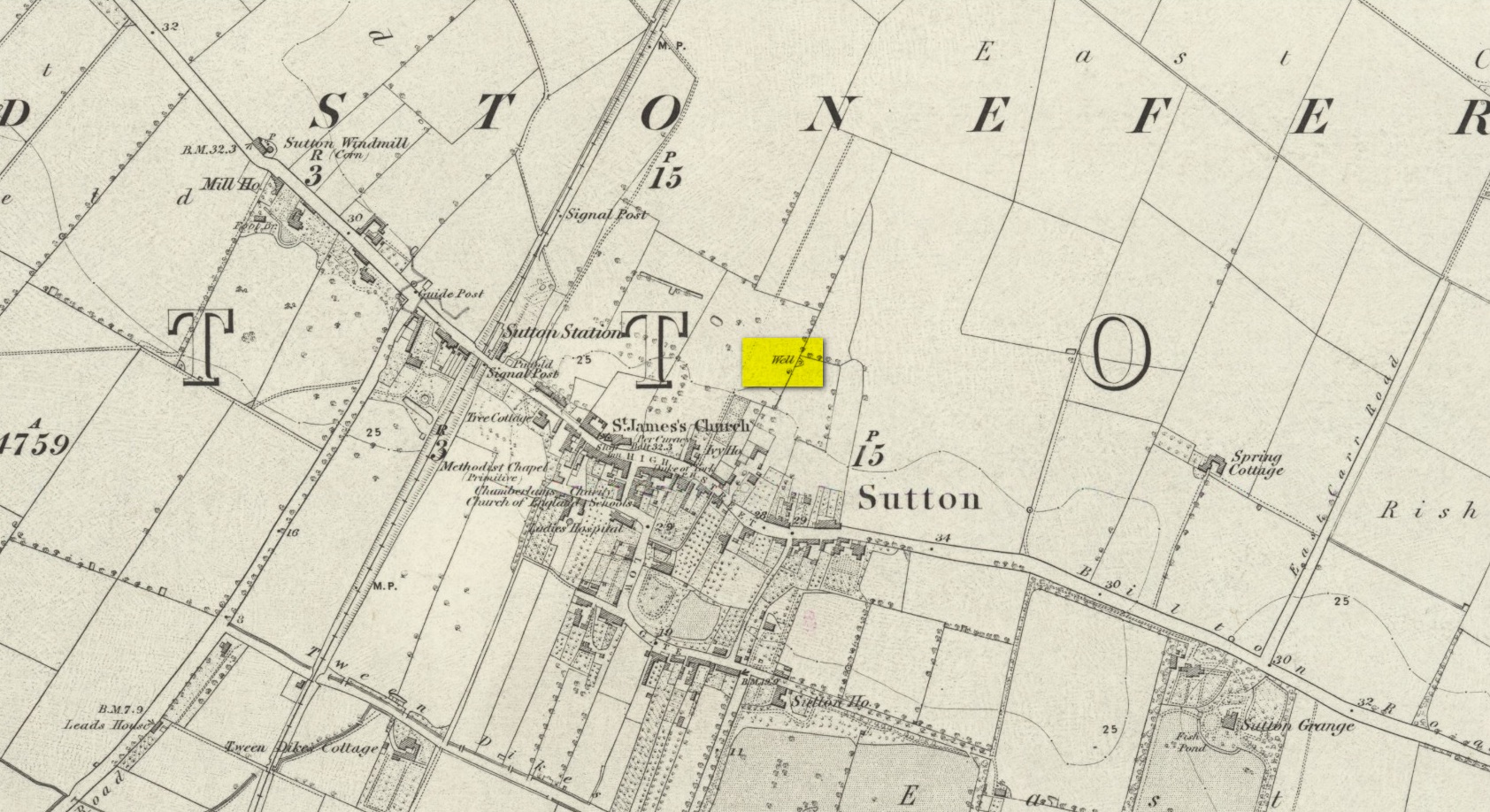
We don’t know for certain the precise whereabouts of this long lost healing well, but it would seem to be the one highlighted here (right) on the 1855 OS-map. However, I think it equally possible that the small unnamed building, roughly halfway between the highlighted ‘Well’ and Spring Cottage, where the walling meets, could be the site in question. It’s one or the other!
Folklore
When Thomas Blashill (1896) wrote of the Blind Well in his standard history work of the area, memory of it was already falling away. In discussing where local people could wash and look after their health, he told that
“There was one place in the parish where washing seems to have been practised as a curative measure. Down in the East Field, near to Spring Cottage Farm, was the Blindwell, to which the people had access. If they used its waters freely when suffering from sore eyes, their faith would probably be rewarded.”
Holy Well (destroyed): OS Grid Reference – SE 80528 42531
Also Known as:
St Everildis Well
Archaeology & History
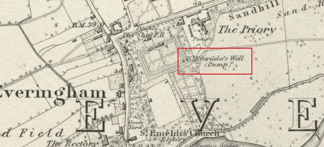
Shown on the 1855 Ordnance Survey map as a ‘pump’, in the grounds of Everingham Priory, the ‘seat’ of the lord of the manor, it was in an enclosure formerly open to the people of the village. It was filled in prior to 1923. The water was described as ‘abundant and excellent.’ Graeme Chapman, in his Yorkshire Holy Wells website states:
‘A few metres to the south of the site of the well the modern OS map marks the start of a stream (SE 8055 4250) which could be the original source of the Holy well’s water.’
The well shown on the 1855 6″ OS Map.
The present writer has not been able to verify this from the materials available to him.
Everilda, also known as Everild and Averil, is recorded in the York Breviary, printed in 1493. She was a mid Yorkshire Saint who died around 700 CE. According to this source she was of a noble Wessex family who went to Yorkshire with companions Bega and Wulfreda, settling on land called Bishop’s Farm, an estate of the Bishop of York, St Wilfrid , which he gave to them, the place being then called Everildisham. There they established a nunnery, of which all trace is now lost. Her Saint’s day is July 9th. The name of St Everilda has been changed to ‘Emeldis’ in the dedication of the church at Everingham. Some historians claim the village is not named after her, but as a derivation of ‘ham of Eofor’s people’. The only other church known to be dedicated to her is at Nether Poppleton, some 17 miles north west of Everingham.
Folklore
The water of the village and the mothers of Everingham are said to have been blessed by St Everilda, and the Reverend Smith wrote that over a fifty year period, no mother had died in childbirth.
References:
Farmer, David, The Oxford Dictionary of Saints, Oxford University Press, Oxford, 1987
Raine, James, The Dedications of the Yorkshire Churches, The Yorkshire Archaeological and Topographical Journal, Vol II, 1873
Salisbury, Matthew Cheung, The Use of York: Characteristics of the Medieval Liturgical Office in York, Borthwick Institute, York, 2008
Smith, Rev William, Ancient Springs & Streams of the East Riding of Yorkshire, A.Brown & Sons, London, Hull & York, 1923
Mentioned only in passing in the Becca and Aberford Enclosure Act of 1825, all remains of this site have gone. It was subsequently referred to by Edmund Bogg (1904) in his journey through Elmet as previously standing where the Roman road veered off to the northeast from the “new road”, as it was then. Bogg’s brief description told that from Nut Hill,
“A little distance south, where the old and new roads part, formerly stood a cross; Highcross Cottage keeps its memory green.”
References:
Bogg, Edmund, The Old Kingdom of Elmet, James Miles: Leeds 1904.
Holy Well (destroyed): OS Grid Reference – SJ 836 985
Archaeology & History
Long since lost beneath the metal and concrete of modern times, even references to this forgotten place are very faint indeed. I expected to find something of it in Henry Taylor’s (1906) giganteum, but it even slipped through his considerable work; and, even where mention of it exists, it is only in passing. In William Proctor’s (1874) survey of early Manchester, he found deeds relating to the land and its early owners wherein the one and only mention of this well appears. It was located near the middle of the city centre, between the Law Courts and Manchester cathedral, in the area known today as the Parsonage Gardens on the east-side of the River Irwell. In earlier centuries this was the abode of a Christian minister, or parson, and the water from this well supplied his religious abode. Proctor wrote:
“Crossing over to the Parsonage, we find that, in 1780, one of its residents was Mr John Quincey, linen-draper, uncle to the English Opium-Eater. In the previous year Mr Quincey was married to Miss Martha Goodyear, of Ardwick. His residence was bounded, it seems, on the north and west by “a narrow street or passage called Black Fryars”; while on the other points of the vane his prospect is thus shown by an extract from a lease dated 1758: — “The orchard or garden plot adjoining the river; it is now fenced out with hedges and ditches.” Some years earlier mention is made of a summer-house, fruit trees, and plants in abundance, with “free liberty of way to the spring or well called the Parsonage Well.” In 1686, Thomas Heyrick of Manchester, gentleman, leased a “tenement and parcel of land abutting upon a messuage and garden heretofore in the possession of George Tipping, deceased, and now the dwelling-house of the warden [Richard Wroe] of the said College; bounded on the east part with the old Parsonage ditch adjoining to the tenement of Mr John Oldfield. Close by are or were the residences of John Nield, Hugh Boardman, Richard Haworth, Esq., and lately Jane Haworth, his widow.” A worn parchment proves the existence, in 1698, of “Parsonage Croft;” another of “Parsonage Pool;” and an order of the Court Leet, 1594, required the tenants to “go along the hedge-side, keeping the footway towards the Parsonage style, for their fetching of water from the river.” In 1765, an advertisement in the Mercury mentions “the sign of the Grey Horse in or near Parsonage Brow.” St Mary’s Church covers the ground once known as the Parsonage Green.”
Holy Well (destroyed): OS Grid-Reference – SE 100 254
Archaeology & History
This sacred site seems to have been destroyed sometime at the end of the 19th century. It was located on the great slopes heading up to Beacon Hill. In 1787, a property survey showed six houses here called Holy Well Cottages and on the 1852 OS-map a “Well” is highlighted at the bend in the pathway of the Old Bank as you’re going uphill, which is the place in question. On my last visit here about thirty years ago, its position was preserved under a large manhole.
References:
Heginbottom, J.A., “Early Christian Sites in Calderdale”, in Proceedings Halifax Antiquarian Society 1988.
Tumuli (destroyed): OS Grid Reference – TL 584 600
Archaeology & History
The precise location of two prehistoric burial mounds at place with the conspicuous name of Beacon Hill, has yet to be satisfactorily located. Their existence is recorded way back, in 1279 according to P.H. Reaney (1943), when they were described as Tweynhowes, being on the boundary of Swaffham Priory. Information on them is scant and scattered with the earliest seeming to be an account by Thomas Kerrich (1817), who reported their removal and finds therein, in 1815. The editor of Archaeologia told us:
Beacon Hill urn, 1817
“The Rev. Thomas Kerrich…exhibited to the Society, an Urn, which had been found a few days before by some labourers who were employed to remove one of the Barrows upon Newmarket-heath, called the Beacon Hills. “It stood upon what probably was the surface of the earth before the tumulus was raised. The diameter of the barrow was near thirty yards, and the perpendicular height probably about eight or nine feet. There are more of these tumuli remaining, some of them very near to the place on which this, out of which the urn came, lately stood. They command an extensive view over the town of Cambridge, Gog-Magog Hills, &c.”
Subsequently a short piece in the Cambridge Chronicle in 1846 told the following:
“Two of the barrows on the edge of Newmarket Heath, belonging to the group called the Beacons, were examined in May 1846 by a party from Cambridge. In one of them nothing was found as it appeared to have been previously opened; in the other the remains of a British interment, consisting of rude vase (now in the Cambridge Antiquarian Museum), a few bones and some ashes, were discovered.”
This was echoed nearly forty years later in a survey by Charles Babbington (1883), who gave little by way of extra information; and was echoed again in Cyril Fox’s (1923) huge archaeological survey. Herein, Mr Fox told us that the two barrows were located at the “east end of a four-mile racecourse.” The only additional lore we’ve had since then is a collation of by the Royal Commission lads who thought that the respective tombs were located more precisely as the grid-references TL 5839 5998 and TL 5850 6004 respectively.
Reaney, P.H., The Place-Names of Cambridgeshire and the Isle of Ely, Cambridge University Press 1943.
Royal Commission Ancient Historical Monuments, Inventory of Historical Monuments in the County of Cambridgeshire – Volume 2: North-East Cambridgeshire, HMSO: London 1972.
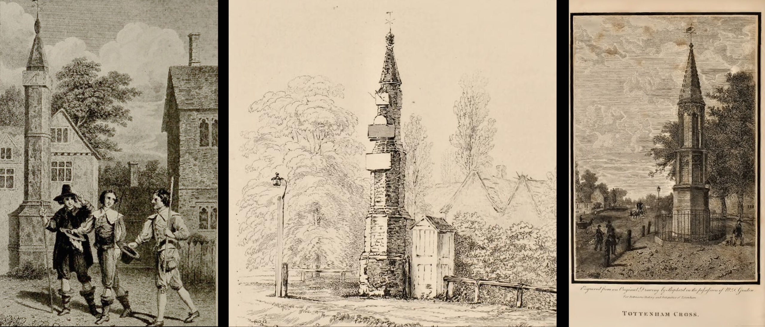
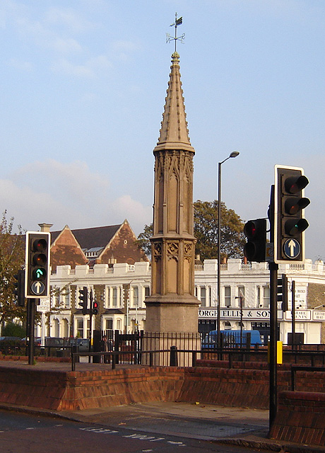
The Cross is on the east side of the A10 Tottenham High Road, on the traffic island at the Monument Way Junction.
Archaeology & History
Cross shown on 1873 map
One of the earliest records of what was called the “hie crosse” is contained in a court-roll of 1456. It was at that time a wooden wayside cross, but there are hints that its origins may go back to Roman times. The Cross is next to what was the southern end of Ermine Street, built by the Romans where there was no pre-existing roadway and described as the most important thoroughfare in Britain: built to give direct communication to the main centres of the military occupation at Lincoln and York. Writing of Roman land survey marks, the now discredited early 20th century Middlesex historian Sir Montagu Sharpe (1932) thought Tottenham Cross possibly marked an earlier (i.e. Roman) stone, although no archaeological evidence has been found to support this. As it was next to Ermine Street it could equally have been a milestone or ceremonial pillar. After the Romans left it may have become a local heathen shrine which, with the coming of Christianity, was ultimately replaced by a wooden cross—but this is speculation, and we will probably never know why and when the original cross was placed where it was.
Originally in the historic County of Middlesex, the settlement of Tottenham surrounding the Cross was known from mediaeval times to the 19th century as ‘Tottenham High Cross’. Local historian William Robinson writing prior to 1840 thus describes the Cross:
“About the year 1580, a column of wood was standing, with a square sheet of lead on the top to throw off the water, supported by four spurs: these, being decayed and rotten, were taken down, about the year 1600, by Dean Wood, Dean of Armagh, who at that time resided in a house on the east side of it, and who erected on its site an octangular brick column, pointed at the top and crowned with a weathercock, and the initials of the four cardinal points, and under the neckings, small crosses, which were called tau-crosses, according to the true cross or Greek letter T.
“Tottenham High Cross, as it appeared in 1788, was an octangular brick pillar, divided into four stories, viz.: a double plinth, first portion of the pillar; second portion, of the same; and a pinnacle; each plinth and story rendered distinct one from the other by certain appropriate mouldings ; and the whole design appeared without any kind of ornament, pointed at the top and crowned with a weathercock. The Cross having fallen into decay, several of the inhabitants of the parish entered into a subscription, in the year 1809, for the purpose of putting it into a proper state of repair, and about the sum of £300. was raised. It was accordingly repaired, and covered with Parker’s cement. The octangular plan, and the proportions of the Cross in its four stories, have not been departed from ; but in other respects it is a new work ; some of the decorations seem to be formed from the exterior and interior of the chapel of Henry VIII; the double plinths or pedestals are as plain as before, but the intermediate mouldings are new; the first portion of the pillar consists of angular pilasters at each cant done with a pointed head; compartment of five turns, connecting itself with another compartment; above it diamonded, with a shield containing an imitation of the black letter. As there are eight faces to the upright, of course there are as many shields, each bearing a letter of the same cutting, beginning at the west face, TOTENHAM: in consequence of there being but eight shields, one of the T’s in the spelling has been necessarily dispensed with. The mouldings between this story and the second are worked into an entablature, with modern fancy heads and small pieces of ornaments alternately set at each angle.
“Second story—small buttresses at the angles of the octagon, with breaks and pinnacles, but no bases. The face of each cant has a compartment embellished with an ogee head, backed with narrow pointed compartments. The mouldings between this story and the pinnacle, making out a fourth story, give, at each angle, crockets, and its termination is with a double finial, but not set out in geometrical rule to the crockets below : there is at the top a vane, with N. E. W. S. The base is surrounded with a neat iron railing on Portland stone curb. The date at which these alterations were made is not placed in any conspicuous part of the structure.”
(left) engraving based on Samuel Wale’s 1759 illustration to Compleat Angler; (centre & right) 19th C views pre- and post-renovation
The craftsman who carried out the modernisation was a Mr. Bernasconia, working to the designs of a Mr. Shaw. Not everyone was pleased by the transformation. A regular contributor identified only as ‘An Architect’ made these caustic comments in the November 1809 edition of the Gentleman’s Magazine:
“Tottenham High Cross has this summer been covered over with Compo: it previously bore a simple appearance, but is now rendered of a very rich and elaborate cast, doing away in the first instance the Architectural history of the erection; and allowing it possible that there might once have been on the spot an Eleanora Cross, holding in contempt, by a want of due imitation, the characteristic style of decoration prevailed at at the time of the Queen’s demise. But according to the system of our Professional innovators, to destroy a sacred relick of antiquity, and to restore it as it is called, upon a model quite in a different style and nature, is one and the same thing. “Any thing is Gothick.”
“….Surveyed November 1809. Entirely covered with the proclaimed everlasting stuff, Compo; a stuff now the rage for trowelling over our new buildings, either on the whole surface, or in partial daubings and patchings; it is used in common with stone work, for instance, on an arcade, half one material, half the other; “ making good,” as it is called (abominable expedient) the mutilated parts of Antient Structures, there sticking on until it reverts (after exposure to the air for three or four years, more or less) to its first quality, dirt and rubbish, and then is seen no more….
“Provided this Compo effort had been advanced on any other occasion, and on any other piece of ground, where no piece of Antiquity was to become the spoil, such as an object to mark the centrical point of three or four counties, a general standard of miles or any other common document for the information or amusement of travellers, all would have been well, and some praise might have been bestowed, for its tolerable adherence to the above style, if not for the material wherewith it is made up. But as nothing of this sort will come in aid of the innovators, and only the barefaced presumption, “ alter or destroy, what was,” is to be encountered, let the detail of parts, put this matter to issue….”
Folklore
A modern view (Wikipedia Creative Commons)
The Cross stood in front of the Swan Inn, a place frequented by fishing writer Izaak Walton in the 1640s when he would go to fish in the nearby River Lea. In 1653 he published The Compleat Angler describing his fishing activities in the classical form of a philosophical dialogue between him as ‘Piscator’ and ‘Venator’ (hunter) and other passing characters, starting and ending his adventures at the High Cross. The 1759 edition of Compleat Angler contains the earliest illustrations of the Cross, with some slight artistic licence, by Samuel Wale.
Afterword
As the Cross now stands in the maelstrom of North London’s traffic, it is worth recalling American traveller Nathaniel Carter’s 1825 observation when travelling north from London:
“Passing Tottenham Cross, we entered a rich agricultural country, possessing the usual charms of English landscape.”
References:
An Architect (pseud.) – Architectural Innovation No. CXXXIX – The Gentleman’s Magazine, November 1809
Anonymous – Tottenham High Cross, The Gentleman’s Magazine, April 1820
Blair, John, The Church in Anglo Saxon Society, Oxford University Press 2005
Carter, Nathaniel Hazeltine, Letters From Europe..in 1825 ’26 & ’27, G & C & H Carvill, New York, 1829
Margary, Ivan D., Roman Roads in Britain, 3rd Ed., John Baker: London 1973.
Robinson, William, The History & Antiquities of the Parish of Tottenham, 2nd Ed., Nicholls & Son, W. Pickering, W.B. Hunnings: London 1840.
Sharpe, Montagu, Middlesex in British, Roman & Saxon Times, 2nd Ed., Methuen: London 1932.
Walton, Izaak, The Compleat Angler, Facsimile of the 1st Ed., containing illustrations from the 2nd US edition by John Major, No imprimatur, 1907.