Long Barrow (destroyed): OS Grid Reference – SO 169 357
Also Known as:
Croesllechau
Archaeology & History
It appears to have been Theophilus Jones who first mentioned this all-but-lost megalithic tomb, more than 200 years ago. He told that,
“In a field called Croeslechau about two miles eastward of (Talgarth), but in the parish of Bronllys and on a farm called Bryn-y-groes, is a cromlech, not merely interesting on account of its antiquity, but from the circumstance of a white thorn growing close, and indeed under part of it, which has gradually raised the horizontal or covering-stone several inches out of its original position; it is therefore not only venerable as a relic of very ancient days, but as a natural curiosity.”
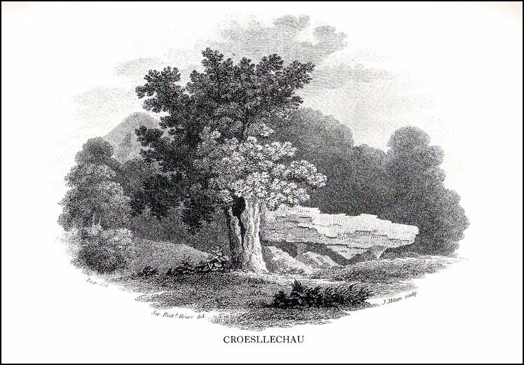
Croesllechau tomb in 1809
Thankfully he gave us the fine old drawing of the tomb, here reproduced.
Although shown on an 1832 map of the region, when Crawford (1925) came to describe this old tomb it had already been destroyed. He told that,
“the site is unknown and all memory of it is has completely vanished in the neighbourhood. Mr Evan Morgan had visited the site and reports that no traces of the ‘cromlech’ were visible; nor were enquiries of the farmer at Bradwys any more successful in identifying the site. It is not unlikely that the monument was destroyed when a new road was made…”
References:
Crawford, O.G.S., The Long Barrows of the Cotswolds, John Bellows: Gloucester 1925.
Jones, Theophilus, History of the County of Brecknock, volume 2, George North: London 1809.
It seems that very little remains of this site, and there is some doubt over its authenticity. Described in Alex Gibson’s (1999b) essay on the cursus monuments of Wales, he said this ‘cursus’ consists of,
“A cropmark of two parallel ditches orientated SE-NW, 15m apart and traceable for some 130m. It runs perpendicular to the present course of the River Wye 50m to the NE. No terminals are visible, but there is a large ring ditch across the river 450m to the NW. A closely-grouped cluster of some 8 ring ditches is visible on a gravel terrace some 150m to the E,” but adds finally that “the identification of this site is suspect and may represent a fossil field system.”
The likelihood of the site being genuine seems to come from the “cluster of eight ring ditches on the gravel terrace some 150m to the east.” Gibson (1999) also thinks how “the parallel ditches seem to be aligned on a ninth large ring-ditch 450m to the northwest and across the river.” Ley-hunters have been scorned by archaeo’s for making such confounded comments! The presence of a long cairn south of the cursus was also thought to add weight to the sites veracity.
Does anyone know what the present position on this site happens to be?
References:
Gibson, Alex, The Walton Basin Project, CBA: York 1999.
Gibson, Alex, ‘Cursus Monuments and Possible Cursus Monuments in Wales,’ in Barclay & Harding’s Pathways and Ceremonies, Oxbow: Oxford 1999b.
Much has been written about this ancient site. Indeed, the archaeologist Alex Gibson (1999) told that, “the ritual complex at Sarn-y-bryn-caled has been extensively studied…and a development sequence based on relative and absolute chronologies, as well as site analogy, has been proposed.” Created over a lengthy period spanning nearly 2000 years, Gibson (1999b) described this monument as a
“cropmark showing as two parallel ditches, 12m apart, running SW-NE for a distance of 370m. Causeways are visible through both side ditches. The terminals are not readily visible on the aerial photographs but have been proven with geophysical survey. The terminal ditches are straight and at right angles to the side ditches. Excavations proved the ditches to be 2m across at the gravel surface and c.0.8m deep. Charcoal from the base of the ditch provided a C14 date of 4960<>70BP. Silting patterns in both ditches and the raised profile of the gravel surface suggest external banks. Towards the NE end of the cursus is a cluster of circular ritual monuments comprising a large pit, timber circle, two ring ditches and a pennanular ring ditch. A possible second pennanular enclosure was located towards the SW end by geophysical survey.”
Less than 200 yards north of the northeast terminal is a second cursus-looking monument, ascribed in Gibson’s (1999b) survey as Sarn-y-bryn-caled II and which runs dead straight for 250 yards. Although being nearly 40 foot across, Gibson thinks this long stretch is more likely to be the remains of an old trackway or road, telling that the very title — Sarn-y-bryn-caled — or “road by the hard hill”, may derive from this secondary linear feature.
Folklore anyone…?
References:
Gibson, Alex & Simpson, Derek (eds.), Prehistoric Ritual and Religion, Sutton: Stroud 1998.
Gibson, Alex, The Walton Basin Project, CBA: York 1999.
Gibson, Alex, ‘Cursus Monuments and Possible Cursus Monuments in Wales,’ in Barclay & Harding’s Pathways and Ceremonies, Oxbow: Oxford 1999b.
Easy enough this one. Take the B4066 west of Woodchester past the Boundary Court and over the cattle grid for 100 yards or so. Note the fence up the slope to your left (south) up the field here head for the triangulation pillar. Once there keep walking for about another 100 yards. You can’t miss it!
Archaeology & History
The mad craniologist John Thurnam (1810-73) was one of several old-school fellas who helped to excavate this grand site on one occasion. Thinking that human sacrifice lay behind virtually all of the burial mounds, Thurnam was part of the Cotteswold Field Club group who investigated the place; and, because of his intellectual capacity in cranial investigations, was listened to by the budding archaeo’s of the day cos he was cleverer than them (hero worshipping). A bit naive of them, but such is the way of some folk! Yet their early account of this site (devoid of Thurnam’s weird notions) is quite invaluable, even today. Described in an address by their President in the Proceedings in 1865, the article tells:
“The Club met at Stroud. The principal work of the day was the opening of a ‘barrow’ on Bown Hill…which had formed the subject of discussion towards the end of the previous season when, the period of the year being too far advanced, the work of exploration was deferred. Workmen had been employed under Dr Paine and Dr Witchell on the two previous days; but beyond the discovery of the entrance to the sepulchral chambers no great progress had been made in the excavation of the mound which, from its size and solidity, proved to be a very laborious operation. In order, therefore, to expedite matters, a strong force of labourers, 22 in number, had been employed from an early hour on the day of the meeting. The mound, which measured about 60 yards in length by 17 in extreme width, was seen to be constructed of angular masses of stone, heaped together without any order or regularity, amongst which were scattered blocks of considerable size and weight.
“The excavators had opened a trench about 100 feet in length, in a direction due east and west by compass. The western extremity was the broadest, the mound gradually diminishing in width to the opposite end. The workmen had struck upon the entrance which, when exposed, showed a chamber formed of five large, unhewn stones, two on each side and one placed transversely, the dimensions of which were 4 feet in width by 8 feet 6 inches in length. There was no covering stone, but the entrance was flanked on either side by a wall of dry masonry, very neatly fitted, forming a segment of a circle, which, if completed, would have enclosed a well-like chamber in front of the entrance to the tumulus. This wall had been abruptly broken off; but there were amongst those present some who thought they detected signs of it having been at one time continuous. It was evident that the whole structure had been thoroughly ransacked and broken up by former explorers; and so completely had the work of devestation been accomplished that hardly one stone was left upon another. The chambers, with the one exception already noted, had been entirely demolished, and but a few bones scattered throughout the whole tumulus remained, all more or less in a fragmentary condition. These fragments comprised one fully developed frontal bone, male; portions of two male lower jaws, and portions of two female skulls; several thigh bones, and bones of the leg and foot, including the remains of children, but all much broken. There were found the remains of six indiiduals at the least, viz, two men, two women and two children, the latter between six and eight years of age. There were several bones of cattle and calves; teeth of horse and ox; a portion of the bones of the foreleg of a dog; several boar’s teeth, tusks and grinders, and parts of jaw bones; a bone ‘scoop’, formed of a shank bone of a horse; and a large quantity of a black unctuous substance, having the appearance of wood or animal charcoal; but no burnt bones. A small portion of a small flint flake was detected in the black paste. Besides the organic remains above enumerated, some pieces of rude pottery were found, which, with a Roman brass coin of the Emperor Germanicus, complete the list of objects yielded…”
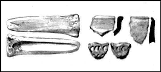
Some of the remains found in Bown Hill’s long barrow
A few years later George Witts’ (1883) described the tomb but added little to the description above. When Crawford (1925) came here in December, 1920, the greatest height of the tomb was just ten feet and he described that “the extreme eastern end has been destroyed by quarrying.” He could clearly discern various trenches and the remains of previous excavations around the tomb, but added little further, apart from an important geomantic ingredient:
“It stands near the highest point (763 feet) of the hill and commands a magnificent view. South eastwards can be seen the Berkshire Downs (probably the White Horse Hill and Wayland’s Smithy); northwards May Hill and the Malvern Hills are visible; in the western distance are the Brecknock Beacons and the Black Mountains…”
Crawford later received further notes about the 1863 dig at Bown Hill from the son of Dr Paine that had been written following the original excavation. Although they convey little extra from the above account, I’ll add the notes to this entry in the near future.
References:
Crawford, O.G.S., The Long Barrows of the Cotswolds, John Bellows: Gloucester 1925.
Darvill, Timothy, Prehistoric Gloucestershire, Alan Sutton: Gloucester 1987.
Grinsell, L.V., The Ancient Burial Mounds of England, Methuen: London 1936.
Guide, W.V., ‘Address to the Cotteswold Naturalists’ Field Club,’ in Proceedings of the Cotteswold Naturalists’ Field Club, volume 3, 1865.
Witts, George, Archaeological Handbook of Gloucestershire, G. Norman: Cheltenham 1883.
Take the A6024 road south out of Huddersfield for about 4 miles, past the turnings to Honley, and when you reach a section where the road runs through a nice bitta woodland, stop! Go into the woods on the western side of the road near the bottom end where a footpath runs up to Haggs Farm. The cairnfield is about 100 yards up into the woods, evidenced by small overgrown heaps in a small cluster. Good luck!
Archaeology & History
These are pretty difficult to locate even when the vegetation isn’t covering them! But if you’re diligent and enjoy a good foray in searching for archaeological remains, you might uncover summat. For here are the scattered remains of what was once a group of seven cairns with adjacent ring-banks, last excavated in the early 1960s by Neil Lunn and other members of the Huddersfield & District Archaeology Society. Little by way of datable material was found, although one of them did “reveal features typical of some Bronze Age barrows.” Beneath this one they found “the remains of a hut or shelter with a succession of small hearths and a group of stone-packed postholes.”
It would be nice to find out the precise status of this area as few other remains seem in evidence, which can’t be right surely?
References:
Barnes, B., Man and the Changing Landscape, University of Liverpool 1982.
Lunn, N., ‘Account of Recent Fieldwork in the Honley Area,’ Hudds Dist. Archaeo. Soc., 13, 1963.
Various ways up this old hill, visible from all angles it seems. I came up via the housing estate near where us friend lives, near Bare Lane Station, through the houses and up the footpath. But you can just as easy (if not easier) walk up from the country lane and fields beneath its eastern side. Much nicer!
Archaeology & History
Torrisholme Barrow
As many northerners will tell: gerrin information from the Lancashire archaeologists about prehistoric sites is troublesome (must be Southerners running the show!). There’s tons of stuff in this good county, but archaeo-info is pretty poor on the ground. This great old tomb for example, is designated as a “round barrow” on the Lancashire County Council monuments and records listing, but there’s no other info telling when it was dug, who by, the size of the tomb, what was found here, etc. Pretty poor to be honest (c’mon chaps – get yer fingers out!). The best info on-line comes from the more dedicated amateur enthusiasts.
A local historian told us that there was nowt up here, but my nose told me otherwise — so up we tramped! It was pretty obvious once we’d got to the top here, that some ancient mound had been built up.
“This has all the hallmarks of a tomb,” I said.
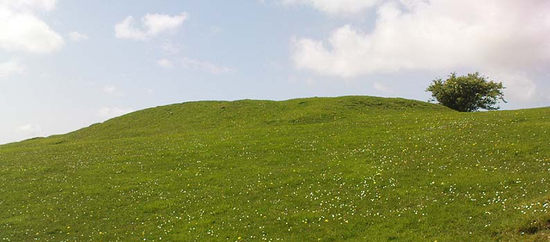
Torrisholme Barrow, looking SW
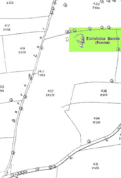
The spirit of the ancestor herein (whoever s/he was) had excellent views and flights to numerous important hills 360° all round here. A perfect place for a tomb! And when we returned into the Darklands of our Yorkshire abodes, we found this notion to be true. Marked on early OS-maps as a tumulus, next to the tell-tale giveaway route of Barrow Lane, there are passing mentions of it in a couple of old local history books I’ve come across, but I’ve yet to find much more about it. It’s a fine mound and of decent size, well worth checking out if you’re in the area. Once I get more details of the archaeological finds from here, I’ll add the data to TNA (but based on past performances and responses from Lancashire archaeo’s, I wouldn’t hold your breath…)
And for any Morecambe historians who might be able to find more: what — if anything — is known of the ‘Fartle Barrow’, now swallowed by the encroachment of the sea, just a few hundred yards west of here?
Folklore
In days of olde, this site was an old moot or meeting hill: one of the northern Law or council meeting hills. Quite how far back this gathering tradition up here goes, aint known. We do know however that there was a christian tradition enacted here, at Easter, of local church doods taking a cross up the top of the hill (does anyone know the story behind the old Cross Hill, half-a-mile south of here?). There’s obviously quite a lot more pre-christian activities occurrent round here than has been previously thought.
At the bottom of the ridge from the (supposedly) singular King’s Park cup-and-ring stone,” in a sand-pit adjoining Douglas Terrace,” we could once find the remains of a now lost prehistoric tomb. First described in the Stirling Natural History Society’s Transactions in 1907, the Scottish Royal Commission lads (1963) told us that, “an urn from this cist was taken to the Smith Institue, Stirling, in a broken condition.” Anymore information about this site, or images of the fragmented urn, would be hugely appreciated.
It does seem very probable that the King’s Park cup-and-ring stone at the top of the ridge from here did relate to local neolithic or Bronze Age burial sites, as I suspected. It’s highly likely that other carvings were (are?) hidden beneath, or round the edges of this Douglas Terrace and Kings Park region, as I suggested a few months ago. It’s imperative that archaeologists in the district pay attention to this area before giving the go-ahead of any further landscape destruction.
References:
Royal Commission on Ancient & Historical Monuments, Scotland, Stirlingshire – volume 1, HMSO: Edinburgh 1963.
Cairns (destroyed): OS Grid Reference – NS 780 926
Archaeology & History
In times past, there were at least two prehistoric tombs in land either side of old Birkhill House, now covered by the M9 motorway. The Scottish Royal Commission lads described the first as being “in the garden of Birkhill House,” continuing:
“This cist contained bones and an urn which measured 5in in height and 6in in diameter, and was ornamented with zigzag lines.”
They think, from its description, that “it may have been a food vessel.” There were also the remains of another tomb to be found in “rising ground to the west side of” Birkhill House. Both of these finds were first described in the local Transactions of the Stirling Natural History and Antiquarian Society in 1880. It seems that little else is known about them. (Thanx again to Paddybhoy for prodding my attention here.)
References:
Royal Commission on Ancient & Historical Monuments, Scotland, Stirlingshire – volume 1, HMSO: Edinburgh 1963.
Cairns (destroyed): OS Grid Reference – NS 783 926
Archaeology & History
At least two old tombs that could once be seen here are long-gone by all accounts. They could be found 200 yards south of the remaining King’s Park cup-and-ring stone. The first was described by the Royal Commission lads (1963) as a well-defined cist, “situated within a gravel mound and (it) contained a skeleton.” Another tomb site was described a few years later:
“A second short cist was found just within the cairn material 3m SE x E from cist no.1. It consisted of a capstone set on built-up side walls, the bottom courses being five slabs on edge. The internal measurements were 64cm long and 48cm wide and 60cm deep. This second cist was orientied NE-SW with its floor made of small pebbles on which lay a late incised beaker and a small piece of human skull.”
References:
Royal Commission on Ancient & Historical Monuments, Scotland, Stirlingshire – volume 1, HMSO: Edinburgh 1963.
Thompson, J.K., “Coneypark: Bronze Age Cairn,” in Discovery & Excavation in Scotland, 1972.
This ‘hill of the big cairn’ is near the top end of the island, past the cup-marked stones of An Carn, just beneath the top of the prominent knoll, a half-mile east of the track. It’s about 200 yards from the summit on the southern side of the hill. More than 50 feet across and about 3 feet high, what may be kerb-stones can be seen on the west-side of the tomb. The Royal Commission (1984) lads tell us that,
“its northern edge is buried under field-gathered stones, and a small enclosure of comparatively recent date overlies the cairn.”
References:
Royal Commission on the Ancient & Historical Monuments of Scotland, Argyll: volume 5 – Islay, Jura, Colonsay and Oronsay, HMSO: Edinburgh 1984.