Cup-Marked Stone (destroyed): OS Grid Reference – NJ 4124 5308
Archaeology & History
Diagonally across the road from Killiesmont, about a hundred yards up the sloping field on “a piece of ground called the Helliman Rig,” could once be seen a large flat stone with cup-markings on its surface. Walter Gregor (1881) told that,
“It lay on the top of a rising ground, and commanded a very wide view of the country, stretching for many miles over the hills of Banff and Moray. In a part of it the rock–a kind of slate–came to the surface. In the rock were cut out nine cups in three rows.”
The carving was earlier described in one of the Topographical Gazetteers of Scotland (1848) where its story is bound up with local tradition and folklore of the land where it lie. There it was described as being “a flat circular stone of about 8 feet in diameter, in which there are a number of holes, but for what purpose tradition is silent.” Subsequently the local historian J.F.S. Gordon (1880) talked of this “large flat circular Stone, of about 8 feet in diameter, in which there was a number of half-pierced holes…. It was too large for a Quern or even a Millstone; and its purpose remained an enigma.”
The stone came to light when a local farmer was digging in the field and, “at the upper end of the Rig, there was found a rude Cist among a heap of stones, which contained ashes.” The cup-marked stone was “turned up” at the same time. It has sadly been destroyed—along with the associated cairn that probably had some relationship with the carving. Prehistoric tombs and rock art are frequent bedfellows and it seems likely that the equation occurred here. But the location of the site had some fascinating local lore told of it…
Folklore
The location of this carved stone in the field called ‘Helliman Rig’, was also known as the Guidman’s Croft or the Gi’en Rig. This was a portion of land that was never to be touched or ploughed as it was “given or appropriated…to the sole use of the devil, in order to propitiate the good services of that malign being.” This devilish tradition superseded the earlier faith of it being a place set aside for the fairy folk and their allies—nature spirits no less. And it’s a tradition found in many places across Scotland and elsewhere, as the account in the Scottish Gazetteer told :
“Like other crofts of this description in Scotland, the present remained long uncultivated, in spite of the spread of intelligence (pedantic bastard! PB). The first attempt to reclaim it was made not more than 50 years since, when a farmer endeavoured to improve it; but, by an accidental circumstance, it happened that no sooner had the plough entered the ground than one of the oxen dropped down dead. Taking this as an irrefragable proof of the indignation of its supernatural proprietor, the peasant desisted, and it remained untilled till it came into the possession of the present occupant…”
This of course fortified the old folklore in the eyes of local people. I’ve found that even up to recent times, such folklore is still held quite seriously by some of the old folk in the mountain villages and hamlets.
Cup-and-Ring Stone (destroyed): OS Grid Reference – NU 0444 0186
Archaeology & History
In an area teeming with prehistoric sites from the neolithic and Bronze Age periods, we had a rare example here of some cup-and-rings that had been carved within a small cave or rock shelter of some kind. Sadly it got destroyed in the mid-19th century due to quarrying operations—but not before George Tate (1864; 1865) had a final sniff of the place and was very lucky to see some of the remains before they finally bit-the-dust. He told us:
“The great sandstone ridge ranges from Eglingham and Beanley across the central part of the county towards Rothbury, near to which is a cave in the rock called “Cartington Cove;” concentric circles with central hollows were incised within this cave. Mr. Williamson of Alnwick, from whom I had this information, played around them when a boy more than fifty years ago; and they were then popularly called “Cups and Saucers.” Nearly all of them have been destroyed by the wedges and hammers of quarrymen; but on visiting the spot in 1859, I found sufficient traces to confirm Mr. Williamson’s testimony.”
But they were gone a few years later thanks to the lads at the quarry. Although the site was subsequently described in Beckensall’s modern surveys (1992; 2006), nothing more was found about them.
Folklore
Whilst David Dixon (1903) reiterated Mr Tate’s notes on the “series of incised concentric circles and central hollows” here, he also mentioned an old piece of folklore:
“At Cartington Cove (is) a recess or cave which, local tradition says, is connected by a subterranean passage with Cartington Castle, three miles distant!”
Intriguing ingredients: caves – Underworld journey – north – all symbolic of Death in pre-christian lore. Just saying…
References:
Beckensall, Stan, Prehistoric Rock Motifs of Northumberland – volume 2, Abbey Press: Hexham 1992.
Beckensall, Stan, Circles in Stone: A British Prehistoric Mystery, Tempus: Stroud 2006.
Dixon, David D., Upper Coquetdale, Northumberland, Robert Redpath: Newcastle-upon-Tyne 1903.
Cup-and-Ring Stone (lost): OS Grid Reference – NT 931 302
Archaeology & History
Little is now known of this carving which was described briefly by Stan Beckensall (1983):
“A cup and ring marked stone was found in the field north of Yeavering Bell in the neighbourhood of the monolith. The last heard of it, according to the Northumberland County History (14:67) was that it was in the grounds of Ewart Park.”
The monolith he speaks of would be the one called the Battle Stone (NT 9299 3038) and Ewart Park is 2 miles ENE of here. The carving remains lost. (the grid reference where the stone was originally located is an approximation, but a pretty good one)
References:
Beckensall, Stan, Northumberland’s Prehistoric Rock Carvings – A Mystery Explained, Pendulum: Rothbury 1983.
To reach here from Stirling or Bannockburn, take the B9124 east to Cowie (and past it) for 3¾ miles (6km), turning left at the small crossroads; or if you’re coming from Airth, the same B9124 road west for just about 3 miles, turning right at the same minor crossroads up the long straight road. Drive to the dead-end of the road and park up. You’ll notice that this is a crossroads of dirt-tracks. Walk along the one that heads to the houses you can see on a rise above the fields, eastwards. About 300 yards on, instead of going up towards the houses, walk thru the gate and along the wall-edge for 85 yards and go thru the gate to your right. You’ll see a small rise covered in gorse trees 100 yards in front you and roughly in the middle of it all, you’ll find this carving.
Archaeology & History
The naked stone
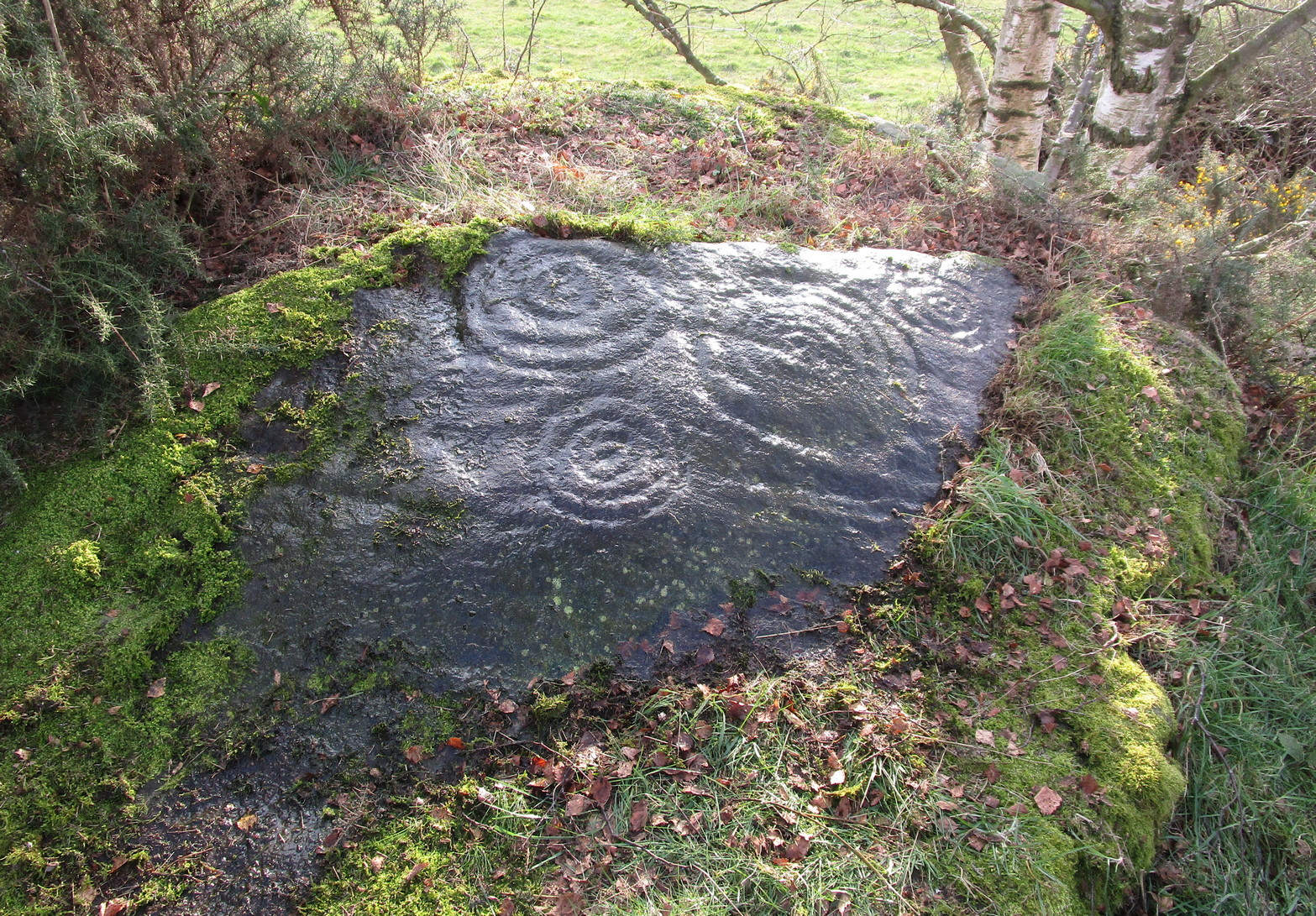
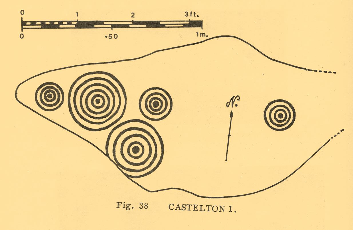
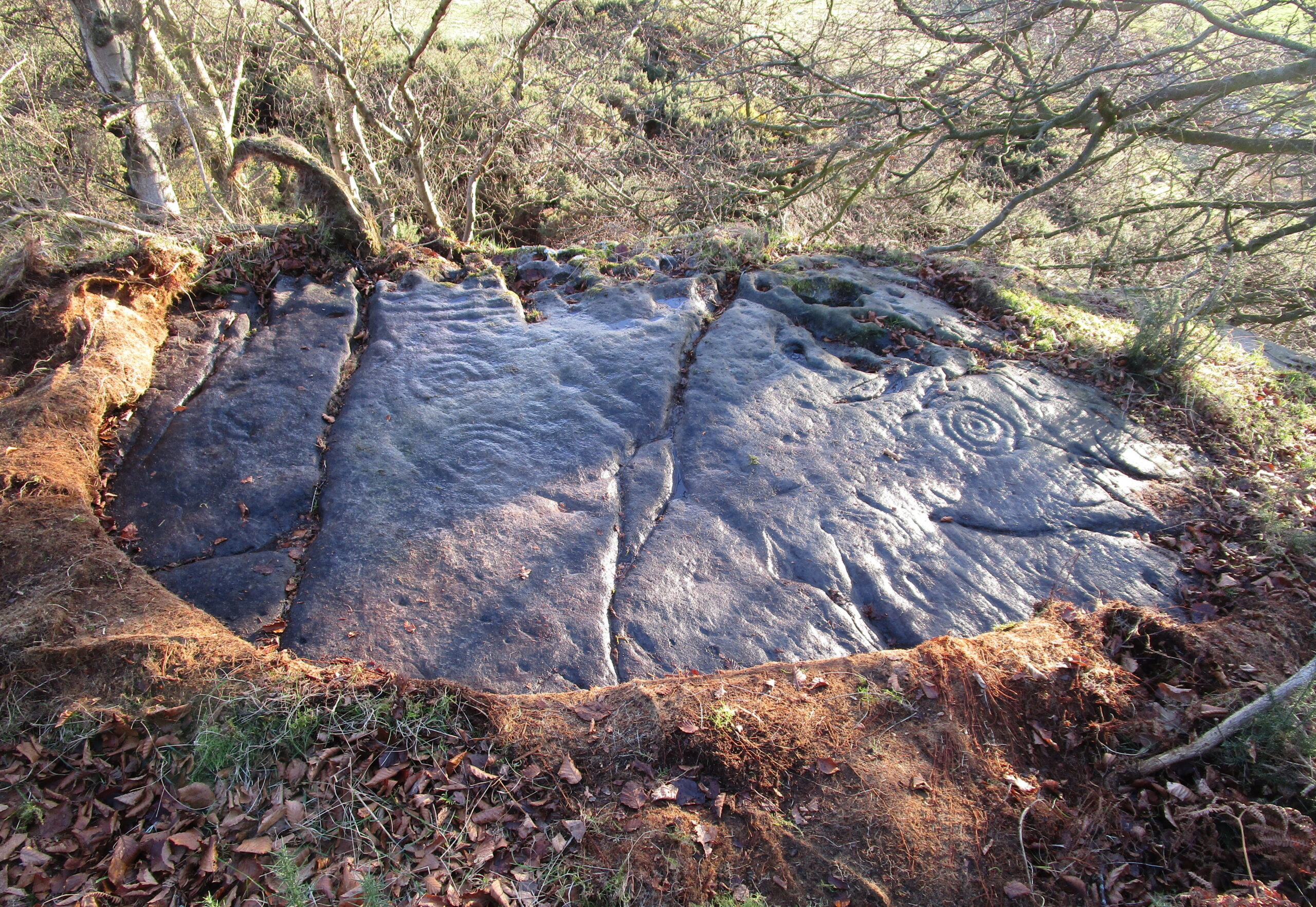
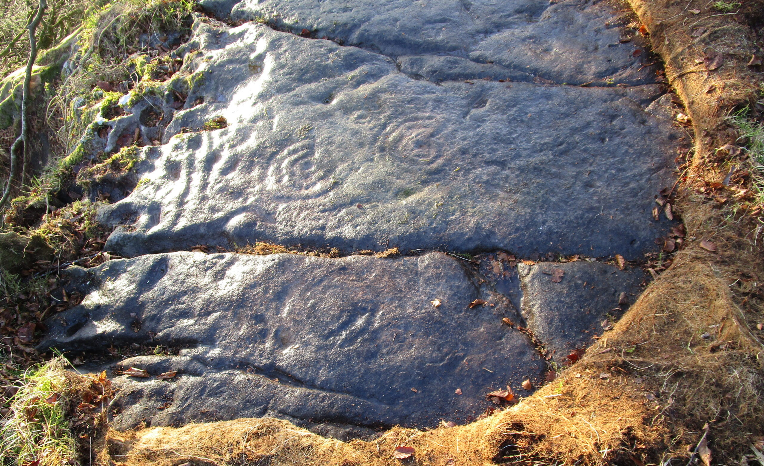
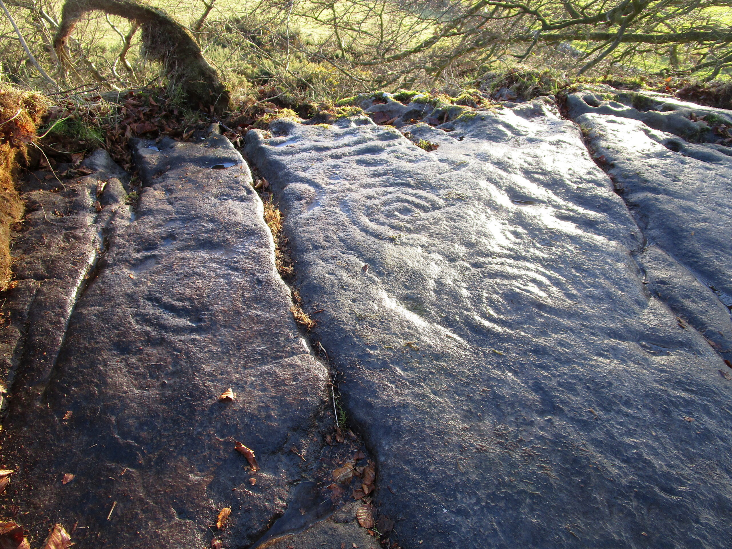
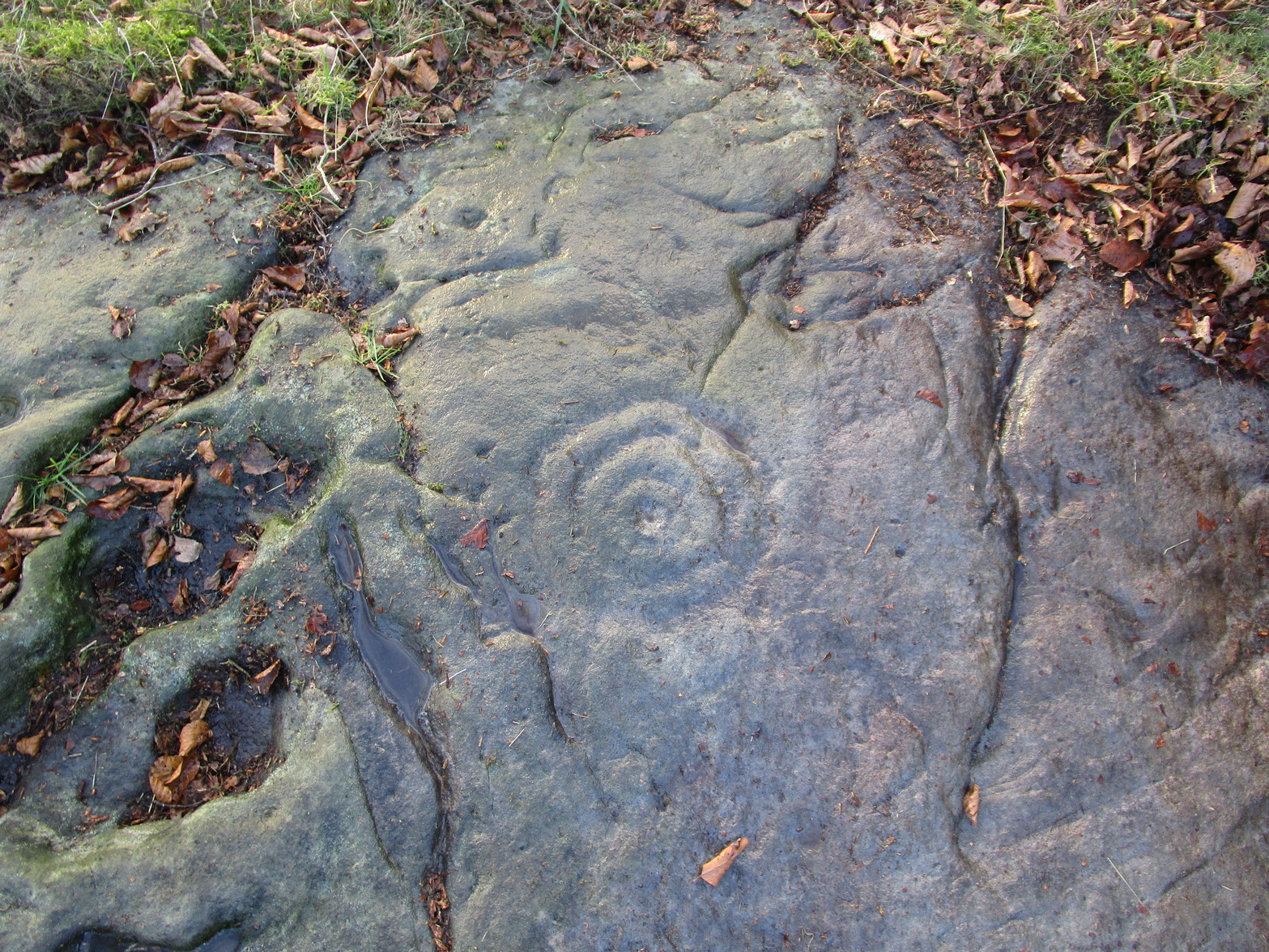
When John Bruce (1896) wrote his article on the mighty Cochno Stone a few miles north of mighty Glasgow, he left some end-notes about a petroglyph near Carnock (near Castleton) that was “found to bear a few much weathered cups with concentric circles.” He wasn’t at all clear where the carving was located, merely telling that it was “in the Gosham Park” area on the Carnock estate. This vague description was probably the reason why, when the lads from the Royal Commission came looking for it in August 1955, they left without success. Nevertheless, when Ron Morris (1981) explored this area he located the place-name of Gosham Field and, therein, this multi-ringed carving. It seems more than likely that this was the carving described by Mr Bruce – and it’s an impressive one!
Despite being eroded by the passage of time, the carved design is still pretty easy to see, comprising a cluster of archetypal cup-and-multiple rings in close proximity to each other, etched onto a sloping stone. Ron Morris’s (1981) description told that, 125 yards east of Gosham Field’s western wall,
“is a prominent greywacke outcrop, part of a rocky ridge running NW-SE, exposed in 1969-75 for 3m by 2m (10ft x 6ft), 4m (12) high on its S, but at ground level elsewhere, sloping 15° NE. On its fairly smooth surface are:
“5 cups-and-complete rings, with no grooves, 3 with three rings, 1 with four, and 1 with five rings, up to 36m (14in) diameters and 1cm (½in) depth.”
Ron Morris’ 1981 sketch
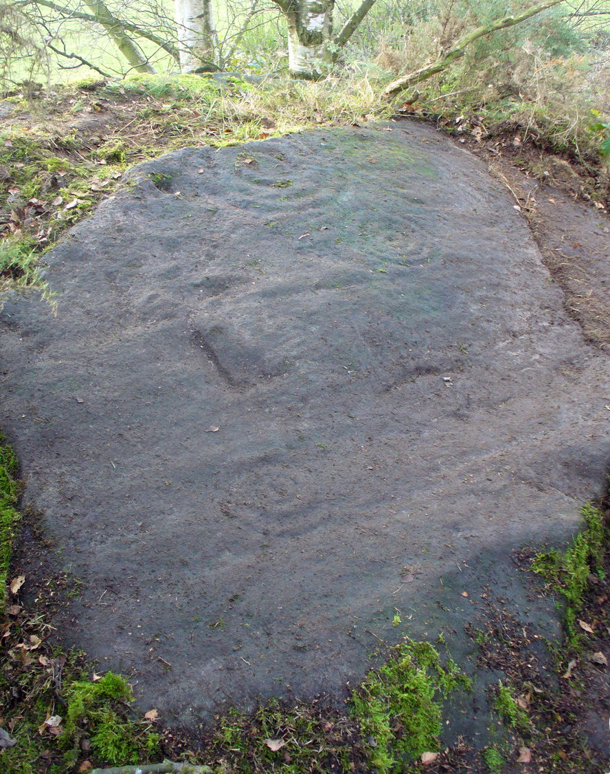
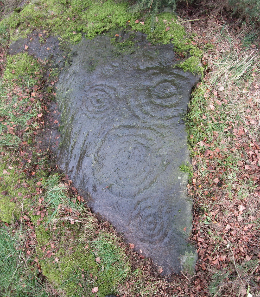
Yet contrary to Morris’ description, there are some “grooves”, or carved lines emerging from some of the rings; faint but definitely there. You can make them out in the accompanying photos above. (are there any sketch artists out there could accompany us to these carvings, so we get some good portraits of the stones?) When Maarten van Hoek (1996) visited this carving he also missed these ‘ere carved grooves.
An additional feature that needs to be mentioned is the cluster of small geological deep natural cups, inches away from the carved rings on the southern edge of this stone (completely covered in vegetation in the attached photos). The same feature also exists on the southern edges of the Castleton 5, Castleton 6 and Castleton 12 carvings and it probably had some mythic relationship with the petroglyph.
There’s another cup-marked stone about 30 yards east of here, along this same geological ridge. It was previously covered in gorse, which was thankfully removed following a fire caused by the hot weather at one of the other carvings, preventing a cracking of the rock which would damage the carvings. All of the rock surfaces in the Castleton complex need to be laid bare to enable a greater visual experience of the wider Castleton complex and to prevent them being damaged by the gorse roots cracking the rocks, as well as stopping fires which will also damage these vitally important petroglyphs. People in the Cowie area want to see and experience their own local history…
Morris, Ronald W.B., The Prehistoric Rock Art of Southern Scotland, BAR: Oxford 1981.
Ritchie, Graham & Anna, Edinburgh and South-East Scotland, Heinemann: London 1972.
Royal Commission on the Ancient and Historical Monuments of Scotland, Stirlingshire: An Inventory of the Ancient Monuments – volume 1, HMSO: Edinburgh 1963.
Royal Commission on the Ancient & Historical Monuments of Scotland, Archaeological Sites and Monuments of Stirling District, Central Region, Society of Antiquaries of Scotland 1979.
van Hoek, M.A.M.,”Prehistoric Rock Art around Castleton Farm, Airth,” in Forth Naturalist & Historian, volume 19, 1996.
Located near the top of one of Castleton’s rocky island outcrops and overlooking extensive flatlands many miles to the south, this impressive multi-ringed carving was rediscovered in May 1985 by the Ordnance Survey lads and, I believe, was first described in an article by Maarten van Hoek (1996), whose description we’ll get to shortly. It’s a design that incorporates some of Nature’s own cup-marks alongside the marks of men.
The overall design here is captured within three sections of the rock: between three large natural cracks running roughly north-south, as clearly shown in the accompanying photos. It’s a multi-period carving, executed over what seems to be a considerable period of time—probably several centuries. I base this on the differing degrees of erosion between the respective multiple rings — a factor found several of the Castleton carvings.
Eastern & central cup ring symbolsCloseup of central rings
One of the most eroded sections can be seen on the eastern side of the rock, where a very faded cup-and-three-rings was carved. Initially it looked as if there was no central cup to this, but as I looked across this towards the falling sun, what seemed to be a possible ‘dot’ was noticed in the centre, very faint indeed. There are several single cup-marks just a few inches east of this triple-ring, which look more recent than its eroded companion.
On the other side of the long natural crack we see two quite distinct multiple cup-and-rings: one with three rings and another with four, both of which have short carved lines running from their centres westwards. Between these, a smaller single cup-and-ring nestles quietly, almost innocuously, minding its own business! But below these two large multiple-ringers there’s a very faint cup-and-double ring, only visible when the light conditions are just right. In numerous attempts I made to catch this element in my photos, none were successful. (I’m a crap photographer, which doesn’t help!) Due to the erosion on this element, this is possibly the earliest section of the carving. Above these rings, close to the edge of the small cliff, one or two carved lines can be seen that run into natural ‘bowls’ which, in all probability, were of some significance to those who made this design. In cultures outside the UK, such elements have sometimes been afforded mythic importance.
Several other natural small ‘bowls’ exist above the most blatant of the cup-and-rings here, on the west side of the rock, which consists of a cup-and-triple-ring no less. Erosion levels on this would seem to suggest that it was the most recent element of this petroglyph.
When Maarten van Hoek (1996) wrote his report, there was much less vegetation covering the stone and another cup-and-ring could be seen on the northernmost section of the rock – as his sketch here shows. He wrote:
Westernmost elementvan Hoek’s 1996 sketch
“Near the edge are five cup-and-rings and possibly up to four single cups, all on rock sloping about 6″ to 12″ NW. The easternmost set consists of the worn remains of three rings (the innermost hardly visible) without a distinct central cup. Across a crack is a cup with four rings, the outer incomplete and curving away; another cup with four rings, mostly incomplete. A small cup-and-one-ring sits in between. South of this group may be some grooves and a single cup, all doubtful being very near the cliff-edge which is heavily pitted by erosion. The westernmost cup with three ovalish rings is the best preserved set of the group. Further away from the scarp is one single cup on a horizontal part and even further N is a cup-and-two-rings on a part sloping 6″ SW.”
It would be good to completely clear this rock and make it all visible again, as it was long long ago…
References:
Morris, Ronald W.B., The Prehistoric Rock Art of Southern Scotland, BAR: Oxford 1981.
van Hoek, M.A.M.,”Prehistoric Rock Art around Castleton Farm, Airth,” in Forth Naturalist & Historian, volume 19, 1996.
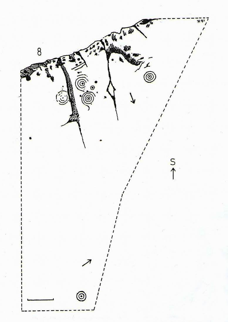
Cup-and-Ring Stone: OS Grid-Reference – C 30754 37541
Archaeology & History
Incredible setting -incredible carving
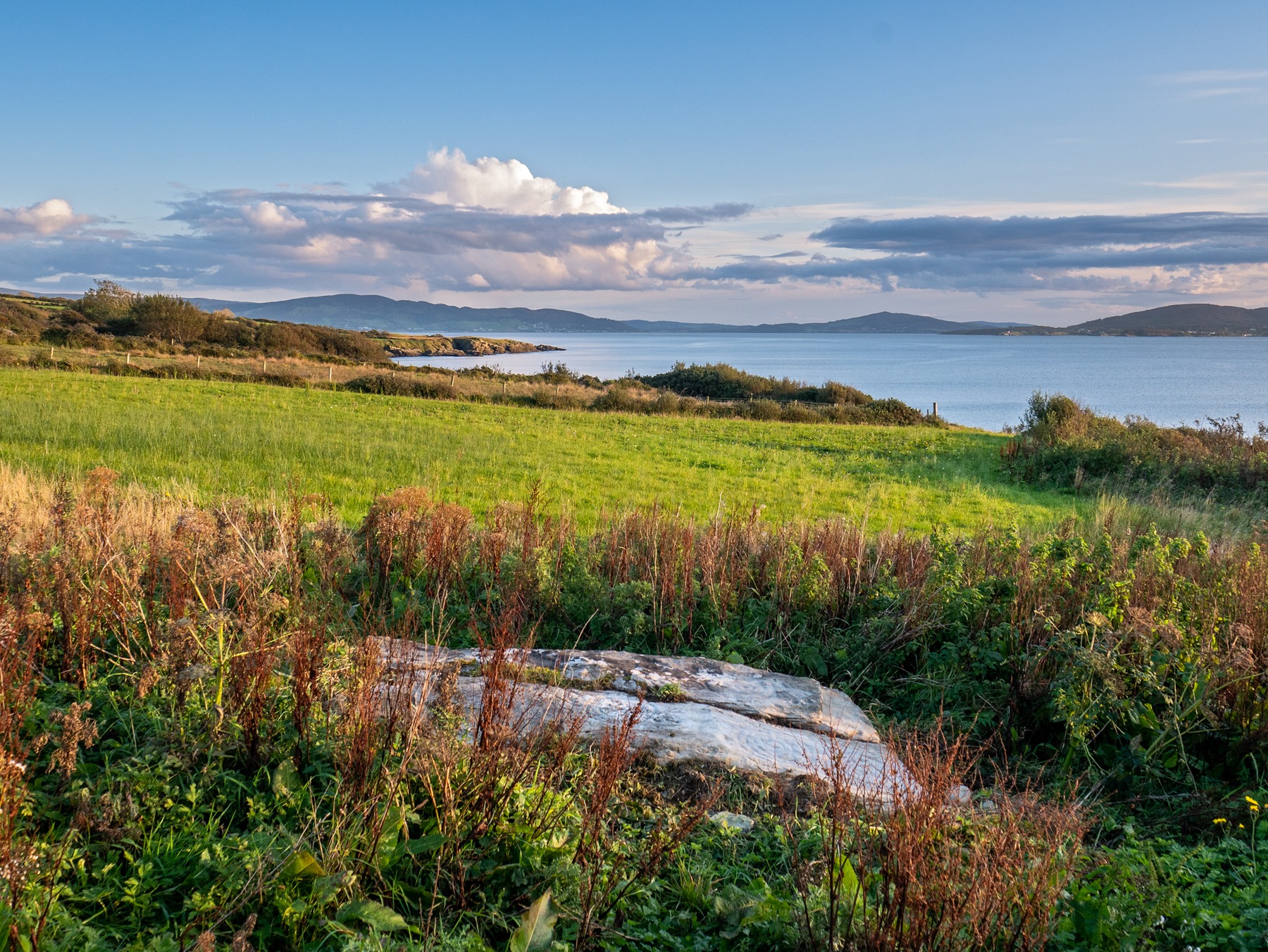
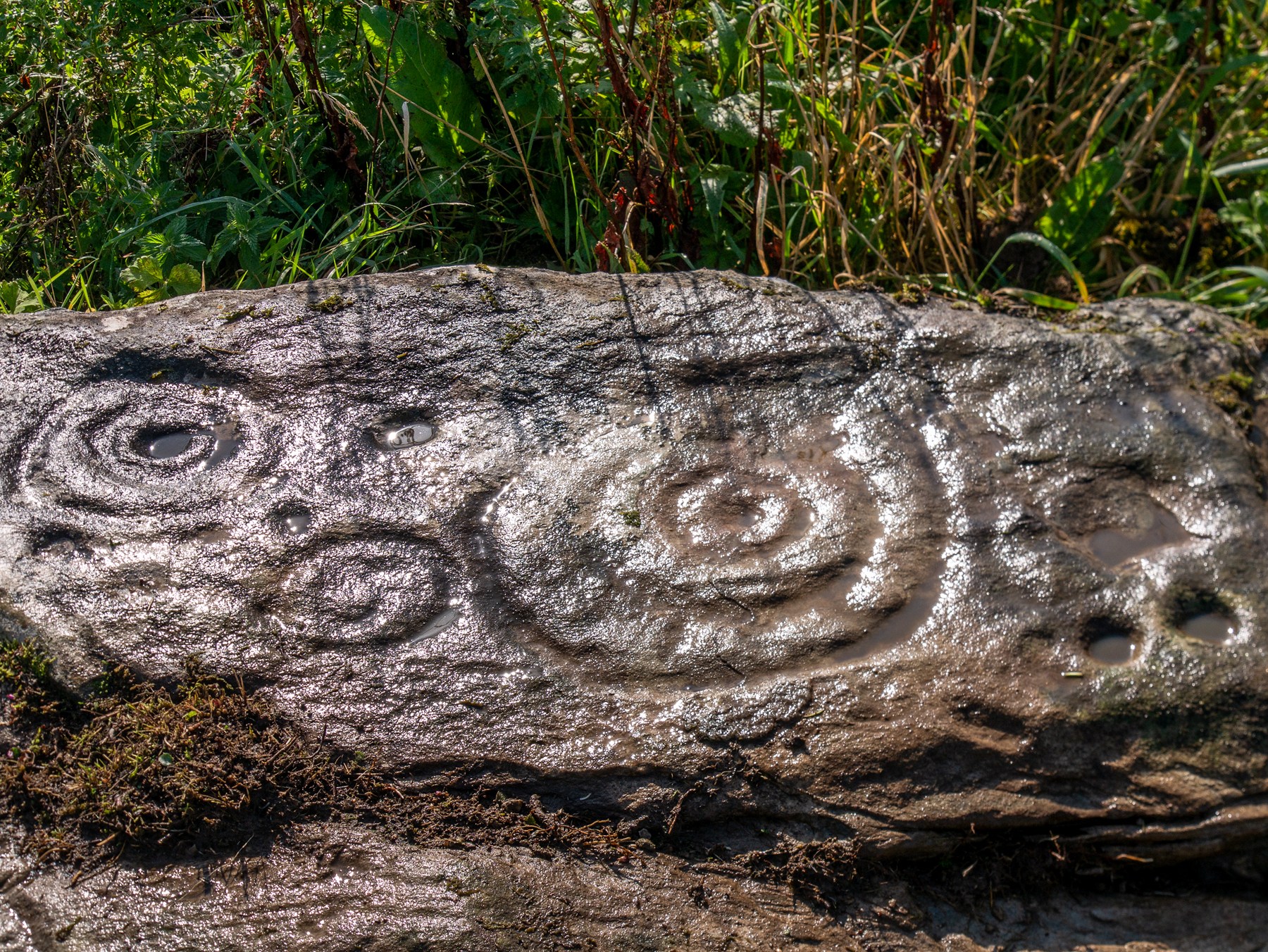
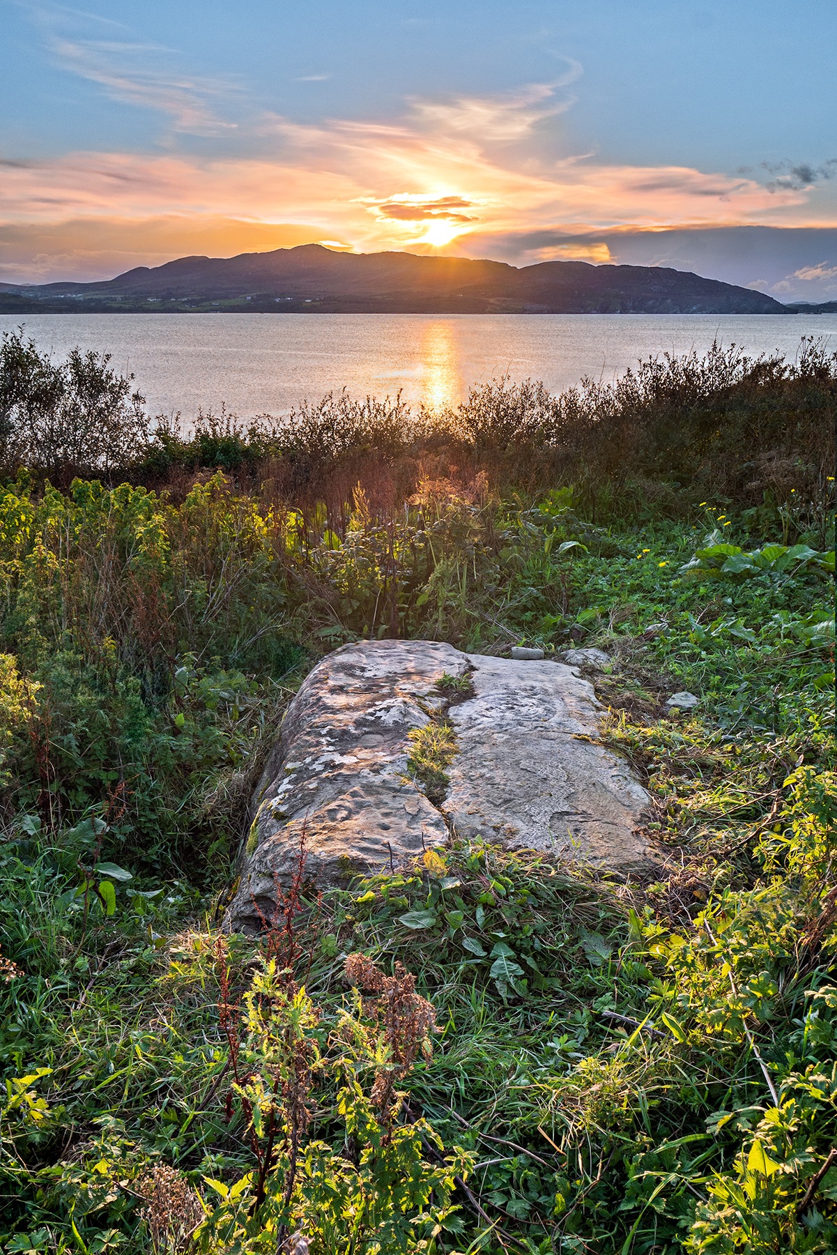
This is an incredible find—dare I say a beautiful find—uncovered beneath the soil a few years ago on farmland close to the shore of Loch Swilly by one of the farm-workers. We were lucky inasmuch as when it was found he noticed curious markings on it. Informing the farmer, between them they peeled back the rest of the soil and found the incredible carving that we see here in Bettina Linke’s photos.
Etched onto a sloping stone overlooking the blue panorama that is Loch Swilly, this petroglyph has a 180º view of the landscape, from the southeast through to the northwest. This panorama—unimpaired by trees thanks to its proximity to the sea loch—was probably an important ingredient in the mythic function of the carving and is something we’ll return to shortly…
Local rock art specialist, Liam McLaughlin was informed of the discovery and, along with Bettina Linke, they met up with the farmer who showed them the carving. I have little doubt that they were very impressed by what lay before their eyes! They told that the rock,
“is aligned east-west with the visible motifs, apart from a few cup marks, situated at the western end of the outcrop. Interestingly, the northern half/leaf is little worn and individual peck marks, made millennia ago, are clearly visible, suggesting it may have been covered for most of the time. The southern half is clearly worn and smoothed out and therefor appears to have been exposed for a considerable amount of time.”
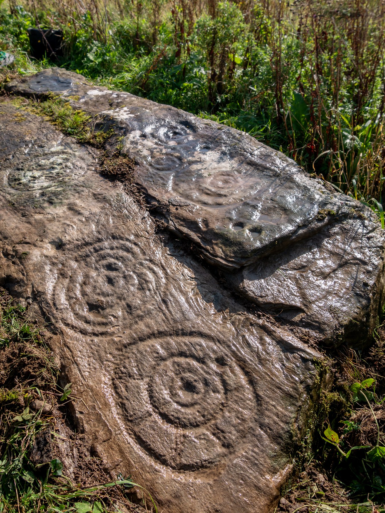
Archetypal cup-and-ringsAncient solar motif?
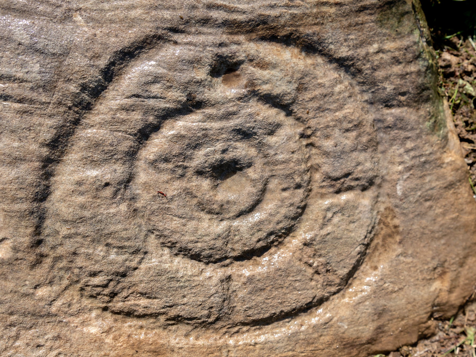
One of the most impressive elements in the overall design is the solar motif, i.e., a series of concentric rings (in this case three) with a number of ‘spokes’ reaching outwards as if to indicate the rays of the sun itself. This is shown clearly in one of Bettina’s photos here. This symbol is found on other neolithic carvings in Ireland: not least the incredible designs in the Newgrange complex where the solar alignment is unmistakable.
The discovery of the carving was reported to the Irish National Monument Service and added to the Heritage Environment Inventory where a detailed report was subsequently written, much of which is extracted here:
“The rock art panel is on an outcrop of bedrock, aligned east to west and slightly sloping in this direction towards Lough Swilly and Knockalla Mountains, also known as the Devil’s Backbone. It lies in an arable field near a field wall in rough ground. Visibility is good to the SE, S, W, and NW across Lough Foyle and the Fanad peninsula.”
On the northern section of the stone,
“There are three large motifs and well preserved with cup and pecking marks between them. There are traces of a fourth large motif on the east end but the rock surface has been eroded or damaged, making it impossible to ascertain the design of the motif.
“Starting from west to east, the top large motif has three rings and a diameter of 43cm. The centre cup mark is shallow and has a diameter of 5cm. There is second shallow cup mark between the 2nd and 3rd ring in the southern part of the motif. Its diameter is 3cm. One tail, is running from the inner ring outwards to the west and a second one is running towards the north. Peck marks, covering the motif, are still visible, particular in the rings.
“The motif below has four rings and a diameter of 39cm. The centre cup mark is very shallow and has a diameter of 4cm. And like in the above motif it has a tail running northwards. But a special mentioning has to be made of the unusual heart shape of its rings with the indentation to the south. Peck marks are still visible in the rings. As far as could be made out, there are five cup marks between those two motifs with diameters between 3cm – 5cm. This part also contains several single peck marks of about 1cm in diameter.
“The next large motif below has a diameter of 37cm, three rings and a centre cup with a diameter of 3cm. A tail appears to divide the motif into an eastern and western half. Another tail seems to run from the centre cup through the inner and middle ring towards east.
“Large peck marks of 1cm diameter cover the entire motif, which can be particular well seen in the embossed space between the middle and outer ring. There are more, large peck marks above the motif to the west as well as four possible shallow and small cup marks. Although the two closed to the motif, in what appears to be a twin configuration, could be two independent but slightly damaged peck marks.
“All of the three motifs on the northern wing leave the distinct impression that they may have been sun wheels with some spokes no longer visible or not visible during our visits.
“The southern wing:
“Like the northern ring the large motifs are placed in the western end of the wing with only a few cup marks on its eastern tip. The edges of the carvings are rounder and more worn, although some rings and cup marks are distinctively deeper. The latter might suggest that these motifs were carved at a different time and by different hands. It also appears that this wing was longer exposed than the northern one.
“The motifs are as followed from west to east: two deep cup marks on the northern side. Diameter for the upper one 5cm in diameter, for the lower one 4cm. There could be a shallow third one below and a damaged one to the south.
“Next in the centre of the wing is a large, three ringed motif with a diameter of 40cm and a centre cup mark, 3.5cm in diameter. Some of the photos show possible if faint tails or spokes, suggesting that this also could be a sun wheel motif. No visible peck marks. Below is a small double ring motif with a diameter of 17cm and a centre cup mark with a diameter of 2cm. Just below and to the south-east is a cup mark, circa 3 cm in diameter. Beside it to the east another cup mark about 5cm in diameter. There are one or two, maybe three circa 2.5cm cup marks in the white lichen area to the north-east of the small ringed motif. And some faint peck marks appear between the large 3 ring motif above and the small ringed motif close to the natural split of the bedrock. The next motif below is a deep double ring motif with a diameter of 26cm and a centre cup mark of 5cm. No tails or spokes could be detected. The white lichen area with up to three possible single cup marks is just beside it, close to the natural dividing crack.
“In the middle of the southern wing are faint traces which suggest that there could have been another motif, now destroyed, of an estimated diameter of 28cm.
“The eastern tip has one large cup mark of 10cm and 3 small cup marks between 2.5cm and 3cm. There might be a fifth but damaged cup mark.”
Somerville’s astronomical linesThe setting sun: a mythic function?
The fact that the stone itself is aligned east-west and pointing towards the outline of the Knockalla Mountains, suggesting “a solar/sunset alignment at the equinoxes” may well be true, but whether this was intended or not is another matter.
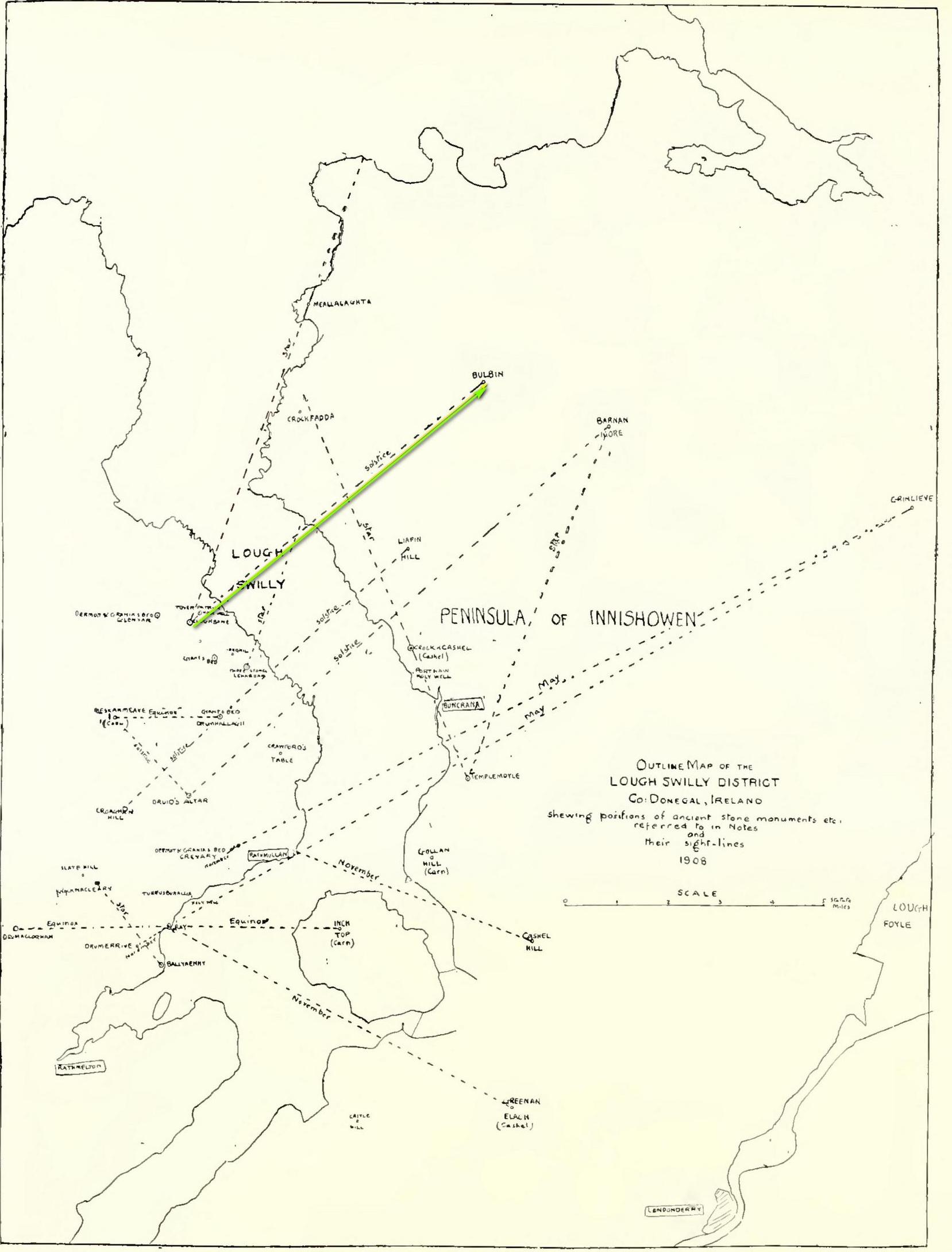
Intriguingly, one of the archaeo-astronony pioneers, Boyle Somerville (1909) wrote a article in the Journal of the Royal Society of Antiquaries of Ireland about a number of summer solstice alignments he thought existed in this precise locale. Amongst them was one he found running from the standing stone at Cloghbane on the other side of Loch Swilly—known as the White or Rowan Stone—heading northeast to the small mountainous peak of Bulbin, approximately 7.1 mile away. Somerville found that,
“The outline of the mountains visible to the northward from Cloghbane shows two sight-lines that undoubtedly were used from this position. One is for the summer solstitial sunrise over the prominent peak Bulbin; the other is over a low and small but conspicuous round-topped headland, towards the mouth of the Lough, which is in line with an exactly similar hill behind it; their two summits being practically coincident, forming a single sky-line; so that, from Cloghbane, their angle of elevation by theodolite is the same.”
The primary motifs
The first alignment is the relevant one here: it not only relates to the rising sun at solstice in 1000 BC, but our Glebe petroglyph lies right on the edge this alignment! (give or take a few yards) Whether or not this is a coincidence we cannot say for certain, but the ‘solar motif’ in the design would seem a strong indicator that implies some sort of solar function here.
As always with cup-and-rings, their non-linear designs tickle our minds with possibilities, probabilities and that there thing called the mysterious, which Einstein described as “the source of all true art and science…”
One final and important thing to anyone who may want to visit this site: please contact the farmer and ask his permission if you want to see it. Cheers. 😉
Acknowledgements: Massive, huge huge thanks to Bettina ‘Grianan Swilly’ Linke for the superb photos and data for this site profile. And (although he doesn’t know it yet!) thanks are also due to the farmer and his employee who rediscovered the carving and to Liam McLaughlin who put pen to paper and told the rest of us about it.
Follow the same directions as if you’re visiting the impressive Fairy Stone carving, then 3 yards east is the Cottingley 2 double cup-and-ring, keep walking past through trees for another 5-6 yards where you’ll come across this reasonably large curved flat stone. Y’ can’t really miss it
Archaeology & History
Cup, with ring faintly visible
This was another carving in the small cluster by the Fairy Stone that I found on my visit here in the 1980s—but it’s a pretty innocuous one to be honest. There’s a faded incomplete “ring” (not really visible on my photos due to pouring rain and very poor light when I was here) with a distinct cup-mark in the middle. Several inches away from the cup-and-ring is a carved line that arcs around it creating an incomplete oval design; and what seems to be a single cup-mark is visible at the top of this oval. Other marks on the stone are both natural as well as recent ‘scratches’.
Some elements of this carving—as with others in this petroglyph cluster—seems to be modern. The cup-and-ring seems to be the real deal, but the ‘oval’ seems to have been added much more recently, perhaps by the scouts who play around in this part of the woods.
A couple of miles east of Crieff, take the A822 road from the Gilmerton junction towards the Sma’ Glen. After literally 1¾ miles (2.8km)—just 100 yards before the track up to Connachan Farm—you’ll reach a dirt-track on your left that leads into the hills. Go along here for 250 yards (230m) yards (the track has straightened out here) and then walk into the reeds on your right. About 15 yards in, look around!
Archaeology & History
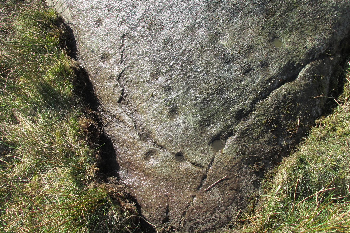
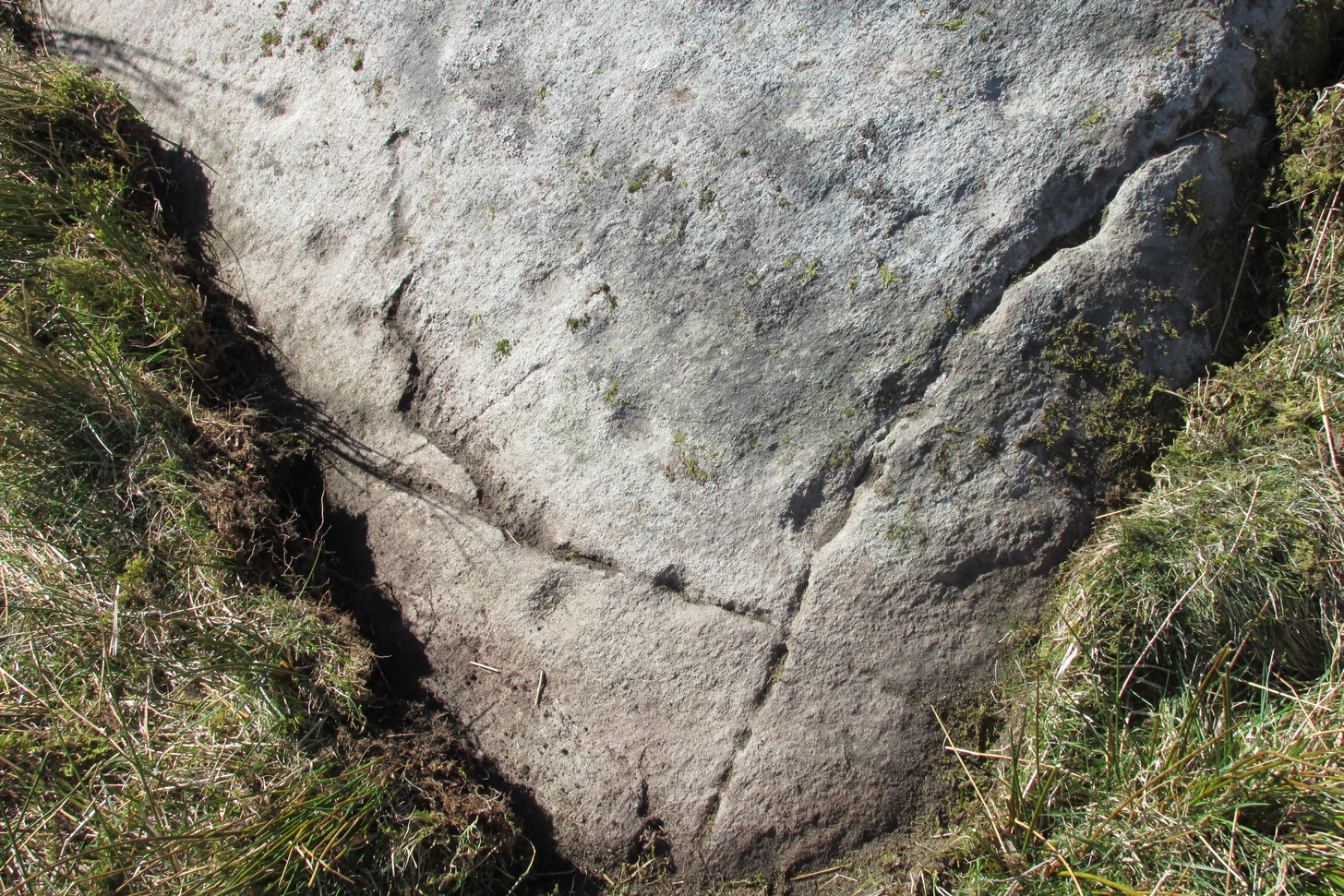
Another one of those fascinating carvings that had me here for an hour, maybe more, poring over more and more features as the light, shadow and rock gave more and more depending on how I looked at it. Tis the same with many petroglyphs, of course… But I liked this one.
On initial impression it didn’t seem up to much: maybe a few faint cups—some certain, others no so much. But the more attention we gave this stone, so more of those unlikely faint cups became much more real. At first there were a dozen; then 15 or more; but as we gave it more and more attention, so more of the petroglyphic design showed its original form. They do that, these stones! When George Currie rediscovered this carving in 2008 he found 17 cup-marks on the stone, but at least thirty of them go to make up this petroglyph. There may even be a very faint, albeit incomplete ring around one of them, but I’ll let the computer-tech kids work that one out!
Natural cracks with cups & carved extensionsNatural cracks with cups & carved extensions
This carving has that peculiar and not-too-infrequent element of having some cups carved into the natural cracks in the stone. In this case, at least four of them can be seen etched into the large deep crack that runs along its more northern edge. They’re quite distinct once you get your focus on them. In this case—albeit it to a much lesser extent—this feature reminded me of the impressive West Strathan carving in Sutherland. But where this natural crack finishes, it has been artificially extended until it reaches the eastern edge of the stone. You’ll also notice in the photos highlighting this feature, that another artificial line has been carved at right-angles to it, heading south, until it meets another natural crack in the stone. It’s quite distinct. And along this second artificial line, you’ll notice another cup or three—one of which has been cut into the line. These two man-made extended cracks in the stone, give the simple impression of an early cross symbol. Features such as this, whilst seemingly trivial to the bog standard explorer, possess some very curious myths in some living traditions elsewhere in the world; but such things are beyond the remit of this site profile.
References:
Currie, G., “Falls of Monzie, Perth and Kinross (Crieff parish), Cup-marked rock”, in Discovery & Excavation Scotland (New Series) volume 9, 2008.
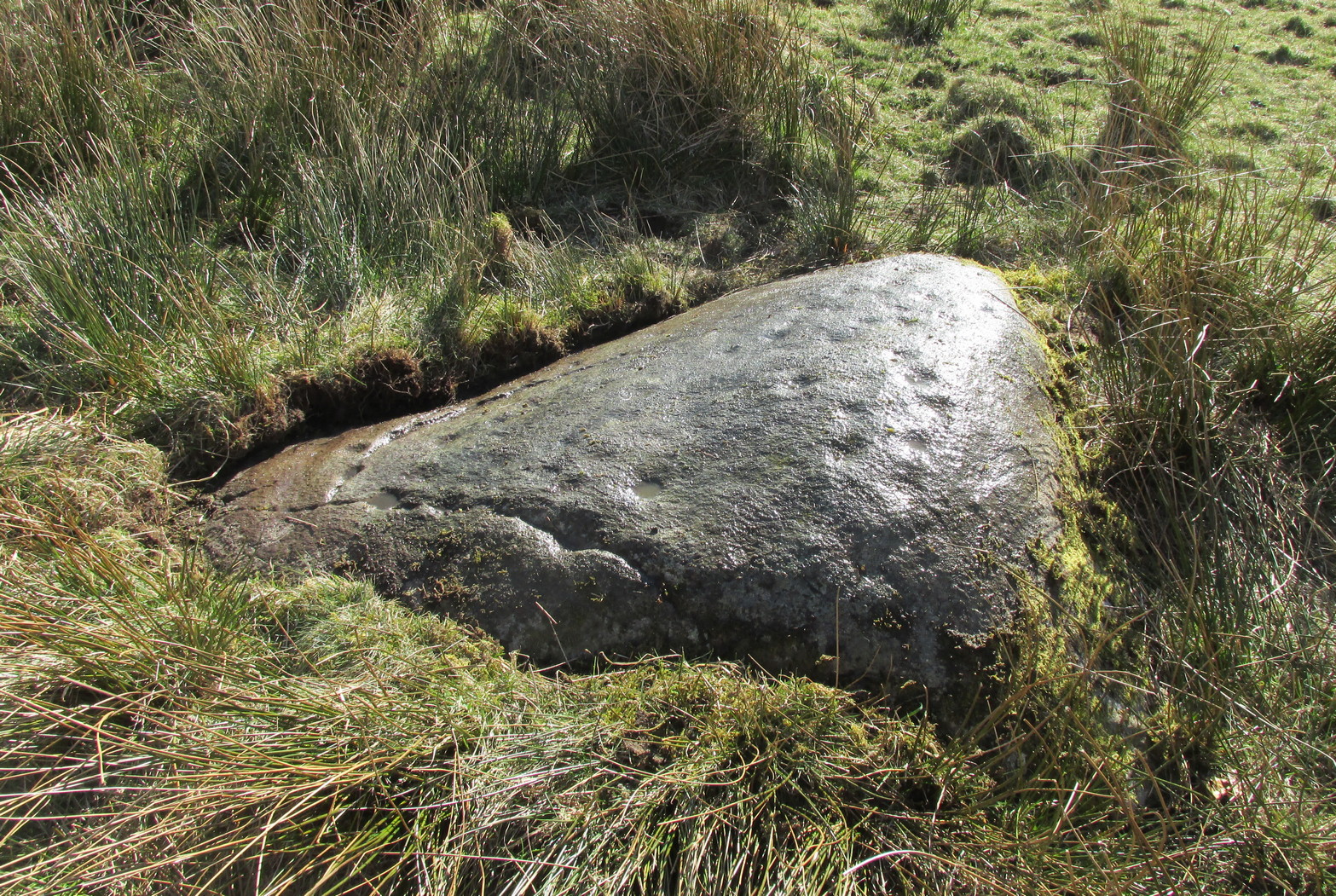
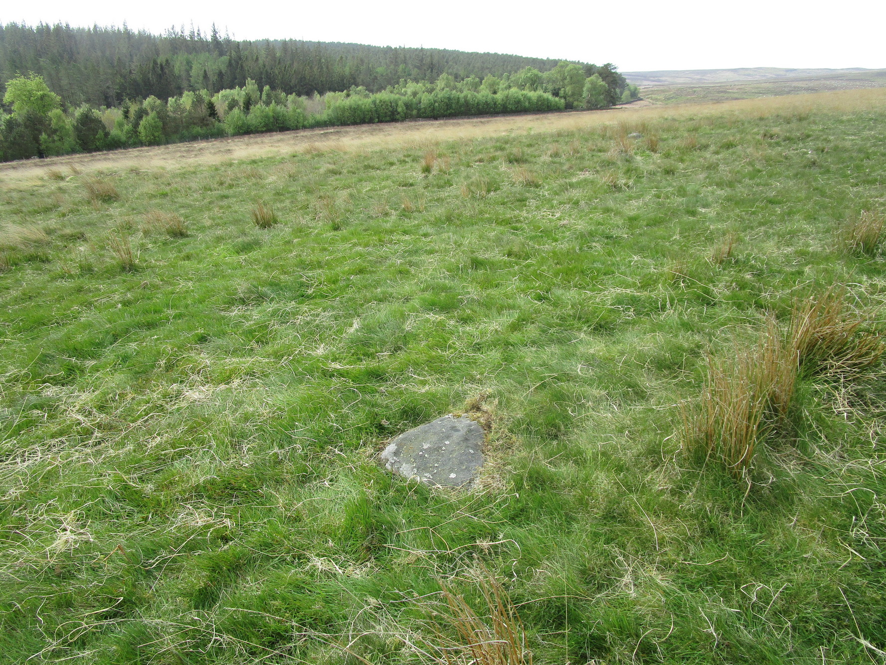
It’s probably easiest to start from the Green Plain settlement, from here crossing the Sun Bank Gill stream and walking east through the scattered heather and grasslands for 450 yards to the right-angled edge of the woodland. Keep walking eastwards alongside the woods for about another 250 yards, then walk into the grasslands north for about 140 yards or so. Zigzag about – you’re damn close!
Archaeology & History
Only for the purists amongst you. This is a simple small triangular stone, with a single notable cup-mark near the middle. It would seem to be in isolation as we could find no others in the immediate vicinity. An early marker no doubt.
Acknowledgements: With thanks to Helen Summerton, who helped with location on this fine day.
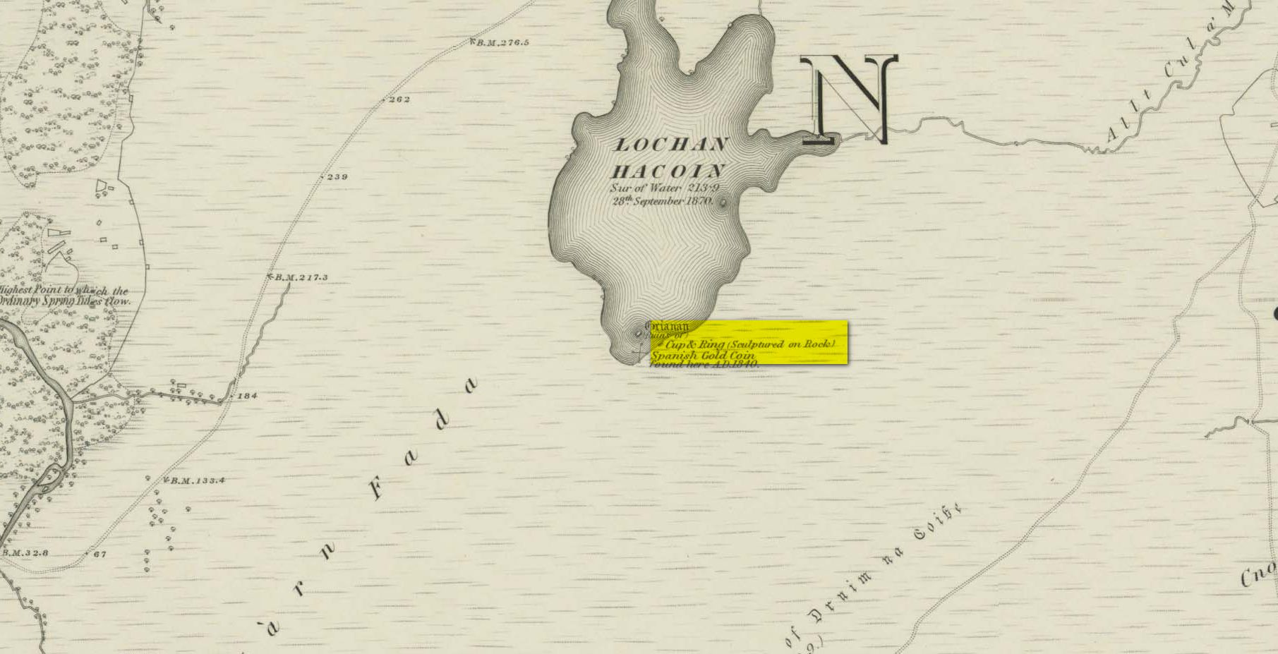
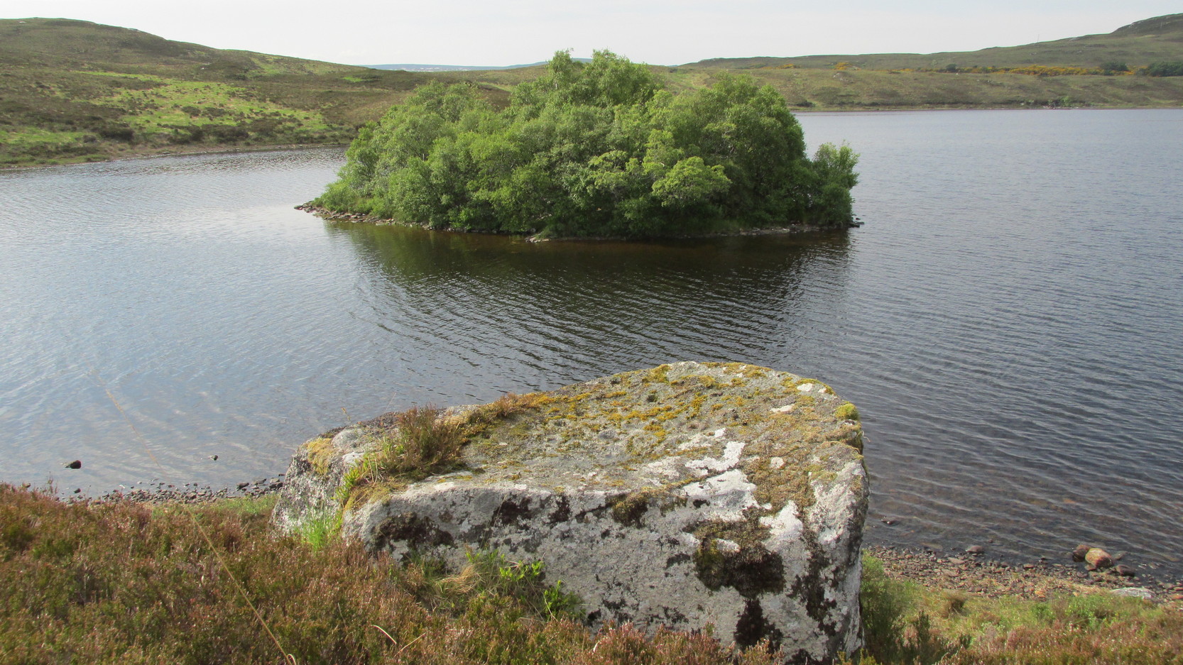
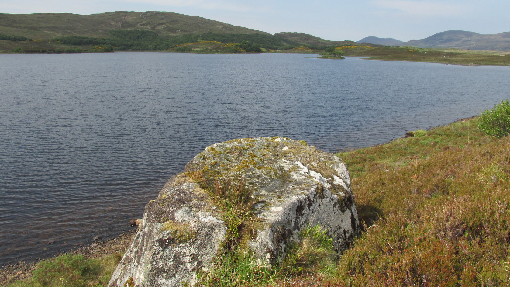
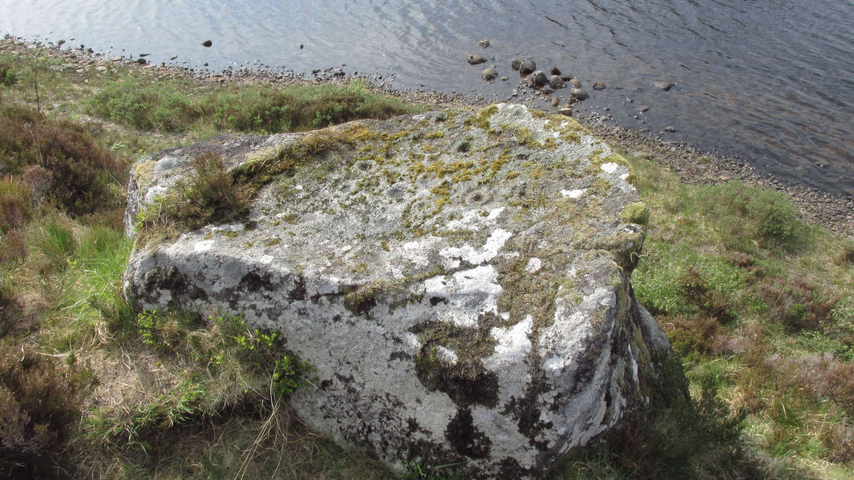
Whether you take the A836 or A838 into Tongue (through truly beautiful wilderness), make sure you go into the village itself—and then keep going, south, along the tiny country road. Nearly 2½ miles along, note the small loch of Lochan na Cuilce on your right. A few hundred yards past this, on the other side of the road (barely visible at first) is Lochan Hakel. Walk around to the south-side of the loch until you find the Lochan Hakel 1 carving. Then look up at the rock right above you. That’s the one!
Archaeology & History
In James Simpson’s (1867) primary work on British petroglyphs, he mentions this site as being in the lands of “Ribigill, near Tongue”, although it is a little further to the south. He said that a certain “Mr Mitchell” had come across it in one of his many rambles in the hills (this was probably Arthur Mitchell, author of the 1880 book, The Past in the Present). Simpson told that he had:
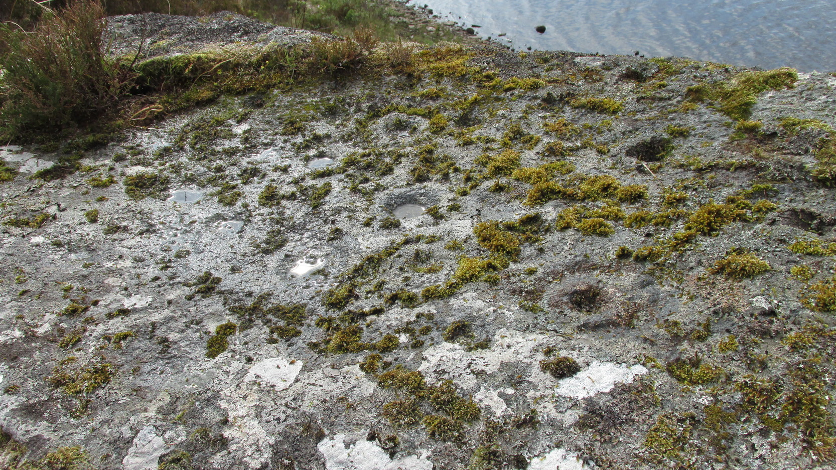
“discovered cups and circles upon a large stone, about nine feet square, apparently lying in its original position, close to the edge of a loch, which contains the remains of an old castle… The surface of the stone shows eighteen or twenty round cup excavations, about an inch deep. There is a ring of ‘hollow around each cup.'”
Although there aren’t rings around every cup, a great number of clear and impressive rings exist around many of them and are, thankfully, still reasonably visible amidst the mass of lichens.
Around the same time as Mr Simpson’s description, James Horsburgh (1868) wrote about the carving, telling us:
The rock and its islandSome of the cup-and-rings
“On the edge of the precipitous bank of the loch, and exactly opposite the island, there is a large boulder with a flat top, and on this there are a number of cups and rings… This stone is not generally known. Old Ross, the gamekeeper at Tongue, first told me of it, and he and I scraped off the moss and exposed the whole. He thought it was for playing some game. On the left of the stone, on a bit separated by a crack, there is a sort of a figure which appears to have been formed by cutting away the stone around it and leaving it in relief, and also some artificial cutting on the right, a sort of circular groove.”
A better description of the carving came near the beginning of the 20th century, when the Scottish Royal Commission (1911) lads included the site in their inventory. They told:
From the rock, looking NThe carving from above
“At the S end of Lochan Hacoin, to the SE of the islet on the top of the bank, is a large earth-fast boulder, on the flat upper surface of which are a number of cup and ring marks placed irregularly over it. The total number of undoubted markings is thirty-four, of which those surrounded by a ring number eleven. No cup with a double ring round it is observable. The best defined cup-mark measures 3″ across by 1¼” deep, and the enclosing ring is 7″ in diameter. Eight of the markings are well defined; the others less noticeable. At the S end there is a boss or projection, roughly rectangular, measuring 12″ x 6″. A sketch of this stone, made about the year 1866 by Mr James Horsburgh, is preserved in the library of the Society of Antiquaries of Scotland.”
Does anyone know if this drawing still exists? Anyhow, whilst you’re stood here looking at this petroglyph, don’t forget to look at the other one on the rock below you closer to the loch-side.
Folklore
In Horsburgh’s essay on the prehistoric remains of the area, he said how local people told that the cup-and-rings “were made by the high heels of a fairy who lived in the castle” on the island of Grianan, just 40 or 50 yards away.
References:
Close-Brooks, Joanna, Exploring Scotland’s Heritage: The Highlands, HMSO: Edinburgh 1995.
o’ Reilly, Kevin, What to See Around the Kyle of Tongue, privately printed 1980.
Royal Commission on Ancient & Historical Monuments & Constructions of Scotland, Inventory of Monuments and Constructions in the County of Sutherland., HMSO: Edinburgh 1911.
Simpson, James, Archaic Sculpturings of Cups, Circles, etc., Upon Stones and Rocks in Scotland, England and other Countries, Edmonston & Douglas: Edinburgh 1867.
Acknowledgments: Huge thanks to Sarah MacLean for guiding me to this carving, and also for the kind use of her photos in this site profile. Cheers Sarah! And to Donna Murray again, for putting up with me whilst in the area! Also – Huge thanks for use of the 1st edition OS-map in this site profile, Reproduced with the kind permission of the National Library of Scotland.