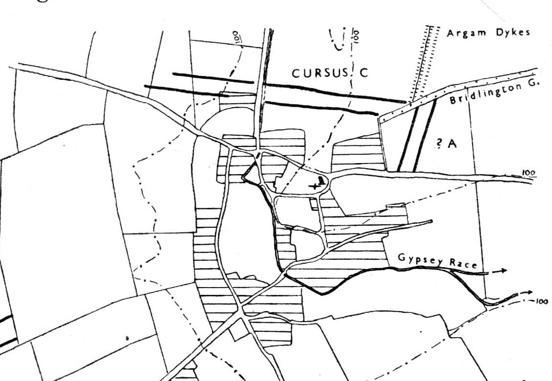
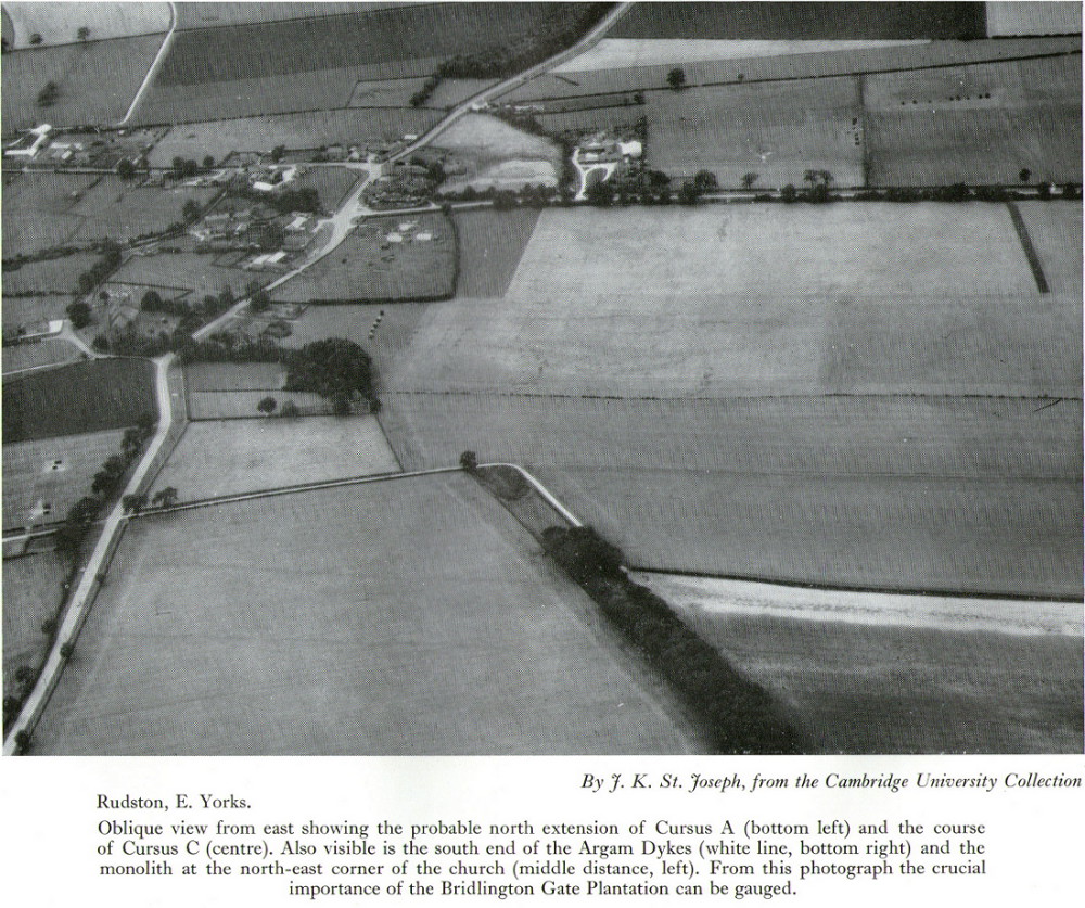
Of the four giant linear cursus monuments that were laid out around the landscape that holds Britain’s largest standing stone—the Rudston monolith—this one, the Rudston ‘C’ cursus, is the one we know the least about. This is mainly due to it receiving the minimum of archaeological attention, which can be forgiven round here as there is so much material to explore! Traces of the cursus at ground level are also quite negligible. Thankfully however, like the other cursus monuments nearby, some of the site can be made out on GoogleEarth.
The alignment of this cursus runs east-to-west, cutting across the Cursus D monument and then running above the northern course of Nature’s curious river known as the Gypsey Race, which local folklore ascribes as being used in animistic divinatory practices. Cursus C was first noticed in aerial photographs taken by Prof. J.K. St. Joseph in 1961 and first described by D.P. Dymond (1966) a few years later, who told us:
“Immediately north of the village (Rudston), two parallel ditches, about 60 yards apart, are visible as crop-marks running east-west for 1000 yards… As they are too far apart to be considered as road-ditches and are similar to the linear ditches (of Rudston A and B), they are best interpreted as a fragment of a third cursus, C. The western end fades out near the York road as it climbs onto high ground, while at the east the ditches disappear into Bridlington Gate Plantation. Like Cursus A, this also crossed the Gypsey Race. Approximately 1½ miles northwest of the last westward point of these ditches is the presumed site of two lost long barrows, joined together at one end. There may, therefore, have been an original connection between Cursus C and these long barrows.”
First faint photo of Cursus C
His final remark is quite a good one! And since Dymond’s initial description (according to the PastScape lads anyhow), Cursus C has been found to be much longer than the initial 1000 yards, growing another 500 yards at least! The final point or ‘terminal’ on the eastern end still remains hidden, as it was intruded upon by the later Argham Dyke and the trees. The start or western terminal also remains unfound, so we don’t know for sure the exact length of this giant neolithic ‘line on the landscape’, as Pennick and Devereux (1989) call them.
References:
Dymond, D.P., “Ritual Monuments at Rudston, E. Yorkshire, England,” in Proceedings of the Prehistoric Society, volume 32, 1966.
Harding, Jan, ‘Pathways to New Realms: Cursus Monuments and Symbolic Territories,’ in Barclay & Harding, Pathways and Ceremonies: The Cursus Monuments of Britain and Ireland, Oxbow: Oxford 1999.
Loveday, Roy, Inscribed Across the Landscape: The Cursus Enigma, Tempus: Stroud 2006.
Manby, T.G., “The Neolithic in Eastern Yorkshire,” in Archaeology in Eastern Yorkshire, University of Sheffield 1988.
Pennick, Nigel & Devereux, Paul, Lines on the Landscape, Hale: London 1989.
Stead, I.M., ‘La Tene Burials between Burton Fleming and Rudston,’ in Antiquaries Journal, volume LVI Part II, 1976.
Decorated prehistoric urn from St John’s Green tumulus
In a prehistoric burial mound that was destroyed by the usual self-righteous arrogance of industrialists, this well-decorated urn or beaker in the old photo (right) was somehow retrieved. Included in Dave Clarke’s (1970) major survey on such vessels (as an Abercrombie type A, no less!), the remains came to light in January 1930, “during the laying of a gas main under the west footpath of Flagstaff Road, about 100 yards south of St. John’s Green.” Although the barrow or tumulus had already been levelled, sheer diligence and care on behalf—one believes—of antiquarian M.R. Hull saved the vessel from an otherwise inevitable doom!
In Mr Hull’s (1946) article on to this and other similar finds in Essex, he described how the urn, about seven inches high,
“…stood upright in the side of the trench, only 18in below the surface. The ground had been disturbed before, and one side of the beaker was badly damaged… The clay was fine, but contains some sparse grit, fairly large and white. It is light brown-red in colour and black in the break. The body is decorated all over with impressed lines, some done with the print of a stick or bone, some in an indefinable way which produces an almost maggot-like impression of varying length, and some with the end of a comb, as on the Type B beakers, but the teeth are oblong (very narrow) instead of square—the comb in fact, was very thin, at least at the point.”
References:
Clarke, David L., Beaker Pottery of Great Britain and Ireland – volume 2, Cambridge University Press 1970.
Hull, M.R., “Five Bronze Age Beakers from North-East Essex,” in Antiquaries Journal, volume 26, Jan-April 1946.
In days of olde, close to the modern M8 on the edge of the modern industrial estate north of Eastfield, was once an old solitary tomb whose home had laid here, undisturbed, until the coming of the Industrialists. Thought to have been a Bronze Age tumulus, it was destroyed sometime around 1768 according to the regional historian David Ure (1793) who told that,
“A small mound at Hamilton Farm was levelled about 25 years ago. In it was found a “stone coffin” containing human bones.”
The Royal Commission (1978) lads think this may have been the same prehistoric tomb that was reported found on the nearby estate of Farme and destroyed that same year. We have no idea what became of the remains and no trace is left of the site.
References:
Royal Commission on Ancient & Historical Monuments of Scotland. Lanarkshire: An Inventory of the Prehistoric and Roman Monuments, HMSO: Edinburgh 1978.
Ure, David, The History of Rutherglen and East Kilbride, Glasgow 1793.
Tumulus (destroyed): OS Grid Reference – TM 0628 2022
Archaeology & History
Alresford Hill urn
In a region well known for the finding of early British remains (Belloc 1905), another prehistoric burial mound was destroyed in the Essex landscape simply due to ignorance and neglect. Thankfully once more we have local antiquarians and an astute schoolgirl for discovering and preserving a record of this site, otherwise we’d have no record of the place at all! Described in M.R. Hull’s (1946) article on some of the Bronze Age relics of the area, he told how a well-preserved urn in the edge of the tumulus,
“was found in June 1942 by a schoolgirl, Miss Anne Pilkington, on the top of the hill overlooking Alresford Creek and the Colne Estuary, about 70 yards northwest of Bench Mark 74.8 and 560 yards slightly west of south from Alresford church, west of the road to the creek and south of the lane running west along the north side of the field. This is the northern limit of a huge gravel-pit. She noticed the vessel standing upright in the side of the pit and recovered it. Nothing else was noticed…
“Afterwards the diary of our late Fellow, Mr P.G. Laver came into my hands and I find under the date 8th July, 1922, that he noticed, when motoring past the site, ‘a definite tumulus, but much ploughed down, now barely 18ins above the field level. It is close to the road through the field, the centre being roughly 20 yards S of the road and about 200 yards from the road to the ford.’ The sketch-plan leaves no doubt on the identity of the site.”
Annoyingly though, Mr Hull didn’t think it worthwhile to reproduce this alleged sketch-map. He did however give us a good description of the urn and its position in the ground, saying,
“The vessel is stated to have been about 5ft below the surface when found, but I am not certain whether the top-soil had been removed or not. The clay is fine, burnt light red, but black within, and the whole body is covered with horizontal lines impressed in exactly the same way as (those on the Flag Inn urn), but much less clearly. The base is slightly hollowed beneath and is not far from having a foot-ring.”
Folklore
Mr Hull (1946) also made an interesting comment on the views of local people about the site where Anne had found this urn, reminding me of what Highland and hill folk would have put down to faerie-lore, though no such memory was noted. He told:
“On enquiry I learnt that no one had observed a mound at the spot, but that it had been observed that exactly there the corn, when the field was cultivated, grew taller and greener in a large round patch”!
References:
Belloc, Hilaire, The Old Road, Archibald Constable: London 1905.
Hull, M.R., “Five Bronze Age Beakers from North-East Essex,” in Antiquaries Journal, volume 26, Jan-April 1946.
Tumulus (destroyed): OS Grid Reference – TM 117 178
Archaeology & History
Bronze Age beaker from the Flag Inn tumulus
Roughly halfway between Thorrington and St. Osyth, a few hundred yards east of the Flag Creek on the grassy wasteland south of the historic Flag Inn, could once be found a fine tumulus, of whose past we sadly know so little. Nothing now remains of the old burial mound apart from a carved urn that once lived therein and was recovered from the site before its final demise. According to M.R. Hull (1946) the well-preserved Bronze Age beaker found here—which he said “stood out as different” from others in this area—
“was found in 1930 on the 50ft contour-line about 200 yards south-southeast of the Flag Inn, in a gravel pit, in St. Osyth parish. The position is a mile and a quarter north-northwest of St. Osyth church. On this occasion it was not possible to examine the site, which could only be established with moderate accuracy some time after the discovery…
“The clay is fine, of light red colour, ornamented with three bands of trellis pattern, each bounded by three horizontal lines, and a band of four such lines at the base, all executed with an instrument making a short line of square impressions, probably the end of a comb used in weaving.”
References:
Hull, M.R., “Five Bronze Age Beakers from North-East Essex,” in Antiquaries Journal, volume 26, Jan-April 1946.
Tumulus (destroyed): OS Grid Reference – TL 8228 2704
Archaeology & History
Aerial image showing ghostly circular outline
This is one of many lost prehistoric burial sites destroyed in Essex in recent centuries and whose only remains now, as seen here to the right, are the ghostly outlines left in the Earth when looking down from above. We are very fortunate indeed in even having a record of this place—this time thanks to an astute fellow antiquarian hearing of some old remains alleged to have been in an old burial mound, south of Greenstead Green.
It’s short story was described in M.R. Hull’s (1946) essay on a series of Bronze Age beakers in Essex that were found in association with once-proud tumuli, living amidst a landscape held as sacred by our peasant ancestors. Although we have no good description of the tumulus, Mr Hull said that this well-preserved clay beaker,
Perces Bronze Age beaker
“was found in 1930 on the 200ft contour-line 366 yards due south of Piercys in the parish of Halstead…that is 2¼ miles south-southeast of Halstead Church. I visited the site immediately after the discovery with our late Fellow, Mr P.G. Laver, and the finder assured us that no other remains were found. He had dug a small pit into the natural gravel, and in doing so came upon this vessel at a depth of 7ft from the surface. When we arrived the burial pit had been destroyed, and, although the depth of the vessel from the surface suggests that a tumulus existed, we were unable to see any remains of it. We found a calcined flint…in the excavation. The vessel…(of) clay is fine, containing a very small quantity of quartz-like grit; the colour is a warm red-brown, and the body is decorated all over with finger-nail impressions.”
References:
Hull, M.R., “Five Bronze Age Beakers from North-East Essex,” in Antiquaries Journal, volume 26, Jan-April 1946.
A prehistoric round barrow with an ancient literary pedigree, dating back to Anglo-Saxon records according to A.D. Mills (1989), when is was described in the boundary records of 833 AD as ‘on burg‘. It was described again in local records as Buleberwe in 1270, then more like the form we recognize today as the Bulbarowe in 1545, and variants thereof many times since then.
Measuring about 18 yards across and standing four feet high, Grinsell (1959) defined the monument as a ‘Bowl Barrow’, due to the shape of the mound. A brief description of the site by the Royal Commission (1970) lads told:
“Bulbarrow (77500574), bowl, lies at about 870ft above sea-level near the summit of the chalk escarpment, here known as Bulbarrow Hill. The centre of the mound has been dug into. Diameter 54tf, height 4ft.”
Grinsell and the Royal Commission both made note of a “sharpened bone of deer”, reported by Mr Woolls (1839), but pointed out there was an uncertainty whether the bone was dug “from this or the Bull Barrow in Holt” parish.
All early forms of the burial mound’s name strongly suggest it derived to a once great bull. The reason for this cannot be known for certain, but if we follow Conrad (1959) or Eliade’s (1986) rationale, the animal here was very likely a sacred bull — akin to the more famous Bull of Minos, or Apis, or Nandi. The religious importance of sacred animals was just as widespread in the British Isles as it was elsewhere in the world (examples of bulls relating to prehistoric remains scatter the British Isles with a similar association: see the Bull Stone, Guiseley; the Creagantarbh stones and hillfort, Argyll, etc.). It would be good to know of any local folklore relating to oxen or other bovines in the Woolland area.
References:
Conrad, Jack Randolph, The Horn and the Sword: The History of the Bull as Symbol of Power and Fertililty, MacGibbon & Kee: London 1959.
Eliade, Mircea, Zalmoxis, University of Chicago Press 1986.
Grinsell, Leslie V., Dorset Barrows, Dorset Natural History & Archaeological Society 1959.
Mills, A.D., The Place-Names of Dorset – part 3, English Place-Name Society 1989.
Royal Commission on Historical Monuments (England), An Inventory of Historical Monuments in the County of Dorset – Volume 3: Central Dorset, Part 2, HMSO: London 1970.
Tumulus (destroyed): OS Grid Reference – SP 641 715
Also Known as:
Oster Hill
Archaeology & History
At the northeastern edge of Torkington Lodge, nearly a mile east of West Haddon, the antiquarian John Bridge (1791) told of the existence of prehistoric barrow that was still visible here around the year 1720. Described by the Royal Commission lads (1981), when they visited the site they found that “no trace of a mound exists.” Just a few years earlier the place-name analysts, Gover, Mawer & Stenton (1975) told that:
“There is a tumulus here and it would seem most likely that the name goes back to Old Scandinavian austr, ‘east’, and haugr, hence “eastern barrow.”
Folklore
Mr J. Bridge (1791) reported how the local people said, “according to vulgar tradition, are buried several officers who fell in battle” within the tumulus. He also suggested the name of the mound derived from “the tumulus of Publius Ostorius”: a Roman statesman and general who governed Britain from 47-52 AD.
References:
Bridge, John, The History and Antiquities of Northamptonshire – volume 1, Thomas Payne: Oxford 1791.
Gover, J.E.B., Mawer, A. & Stenton, F.M., The Place-Names of Northamptonshire, Cambridge University Press 1975.
Royal Commission on Historical Monuments, England, An Inventory of the Historical Monuments in the County of Northamptonshire – Volume III: Archaeological Sites in North-West Northamptonshire, HMSO: London 1981.
Takes a bitta finding unless you’ve got a GPS system, or someone like me to show you where it is! The best way’s probably via the Askwith Moor Road car park, up the road 160 yards till you hit the straight line cut into the moor on your right, where the landscape’s been damaged.* Walk along this for less than 100 yards, then walk right, through the heather and onto the singular tree roughly 200 yards away. From here, walk 75 yards (strides) north from the tree. You’re damn close!
Archaeology & History
About 20 feet from a line of ancient walling in an area pretty rich in prehistoric sites, is this medium-sized stone with a lovely cup-and-ring design. The carving was first recorded by fellow antiquarian, Eric Cowling (1937), in his short survey of other carved stones in the area. He called this ‘carving no.7’ and described it, thus:
“In the central area of Snowden Carr is a barrow group, which occupies a slight ridge running from the edge of the bog to the east, almost to the moor road on the west. The ridge is almost devoid of vegetation except at the higher end. Here, on a heather-covered boulder, is marking no.7. The cups are smaller than usual, and only one ring completely surrounds a cup. The lines linking the cups are only lightly incised, and the whole marking has a delicate appearance.”
Old photo of the carvingCowling’s 1937 sketch
I first visited this stone in the 1980s with fellow rock art student and author, Graeme Chappell, and for some reason it has always impressed me (I recall Graeme laughing whilst I made joyous noises and stroked the rock, reverentially!). Cowling’s description of the stone as ‘delicate’ is appealing, as the stone and its design has a nurturing aspect to it, female in nature. (forgive me — but many of these stones tend to capture me in such ways!) The stone was described more clinically in Boughey & Vickerman’s (2003) more recent survey, in the way that archaeologists tend to do, saying plainly:
“Fairly large, flat, smooth grit rock with crack. Up to seventeen possible cups, one with complete ring, one with partial ring, one with possible ring; connecting groove.”
Doesn’t quite capture the feel of the place, which I’m sure they’d admit. The next time I’m up here, I’ll get some better photos of the carving.
References:
Boughey, Keith & Vickerman, E.A., Prehistoric Rock Art of the West Riding, WYAS 2003.
Cowling, E.T., ‘A Classification of West Yorkshire Cup and Ring Stones,’ in Yorkshire Archaeological Journal 1940.
Cowling, E.T., Rombald’s Way: A Prehistory of Mid-Wharfedale, William Walker: Otley 1946.
Cowling, E.T. & Hartley, C.A., ‘Cup and Ring Markings to the North of Otley,’ in Yorkshire Archaeological Journal 33, 1937.
ACKNOWLEDGEMENTS: Huge thanks to one of my fine ladies, Inmaculada Ibanez-Sanchez, for the drawing! Cheers Inma!
* A pipeline was laid across the moor here, and subsequent work (I presume by the same company) was done again in early 2011, cutting through and damaging several prehistoric monuments and destroying at least one prehistoric cairn. An archaeological survey of the region should have been done before any work proceeded here, but I’m unaware of any such excavations, or archaeological reports preceding or concurrent to the ecological and historical damage performed.
From Marsden itself, take the A62 road west and where the road bends round, the large hill rising on your left is where you’re heading. There’s a parking spot near the bottom of the highest part of the hill. From here, walk right to the top, up whichever route you feel comfortable with. At the very top is an intrusive modern monolith (dedicated to somebody-or-other, which the fella wouldn’t approve of if he really loved these hills*). About 10 yards east of the stone is a small grassy mound with a bittova dip in the middle. That’s it!
Archaeology & History
This is a little-known prehistoric site, whose remains sit upon a very well-known and impressive hill on the western edges of Marsden. Described in Roy Brook’s (1968) excellent survey on the history of Huddersfield as “the most important site” from the Bronze Age in this region, it seems curious that the attention given to it has been relatively sparse and scattered. The tops and edges of the hill have been cut into and worked upon by the uncaring spade of industrialism (of which there is much evidence), aswell as much of the peat being used for fuel over countless centuries — some of which appears to have been cut close to the all-but-lost remains of this once-important burial site.
The first description of the hill itself seems to be in 1426, where it was named in the Ramsden Documents, “past’ voc’ le Pole.” (Smith 1961) It wasn’t until appearing as Puil Hill on the 1771 Greenwood map that the title we know of it today began to take form. Local people would alternately call it both Pule and Pole Hill. But its name is somewhat curious, as the word appears to derive from the variant Celtic and old English words, peol, pul and pol,
“meaning a pool or marsh, especially one that was dry in the summer. Pole Moor therefore means Pool or Marsh Moor…and Pule Hill = the hill in the marsh.” (Dyson 1944)
Remains of mound looking NWSmall mound at left-centre
However, in Smith’s English Place-Name Elements, he gives an additional piece of word-lore which seems equally tenable, saying the word may be “possibly also ‘a creek'”, which could be applied to the water-courses immediately below the west side of the hill. We might never know for sure. But the archaeological remains on top of Pule Hill have a more certain history about them…
The burial site first appears to have been mentioned in a short article by Henry Fishwick (1897), who wrote:
“Whilst searching for…flints on the summit of Pule Hill a few weeks ago a discovery was made which is of considerable antiquarian interest. On the highest point of the hill, and from 12 to 18 inches below the surface, were found two human skeletons lying on their sides almost directly east and west, the knees of both being drawn up. Near to them were two small circular urns measuring 4¾ inches high, 5 inches across the top, and 6 inches in diameter at the widest part, the base being 3 inches across. These are made of native clay very slightly burnt, and are ornamented with short lines (apparently cut with some sharp instrument) which forms a rough herring-bone pattern. On the centre band are four ears or small handles which are pierced so as to admit a small cord. The urns contained animal matter and a few calcined human bones.
“Since the discovery of these two urns another has been exhumed from the same place. It measures 3½ inches in height and 7 inches in diameter at the widest part, which is just below the rim of the mouth. Its ornamentation is similar to the others, but quite so elaborately executed; the base is made with four feet or claws. On one side of the urn is an ear or handle pierced with a small hole in the direction of a double-groove, in which it is placed; there is a second double-groove near the bottom. When found this urn only contained sand. Fragments of a fourth urn were discovered on the same spot… The discoverers of these were Mr G. Marsden and Mr F. Fell.”
As a consequence of this, a couple of years later members of the Yorkshire Archaeology Society took it upon themselves to have a closer look at the place — and they weren’t to be disappointed. They cut a large trench across the top of the site from east to west, digging down until they hit the bedrock of the very hill; then dug an equal trench as much as 30 yards to the north, and on the southern side to the edge of the hill near where it drops. They came across,
“In three places were found distinct cavities…driven into the rock to a depth of about eighteen inches, the dimensions of which…averaged three feet long by two feet wide.”
Drawings of urns & bowls (Manby 1969)Mr Petch’s old photos of the bowls & urns
Within these rock cavities they found small portions of bone, charcoal and flint. It was also found that the urns which were described earlier by Mr Fishwick, had been found laid on their sides “at the places where the cavities were subsequently discovered.” Inside the urns, the remains of various human bones were discovered and reported on by Mr Boyd Dawkins: a craniologist of some repute in his time.
The discoveries were remarked upon a few years later — albeit briefly — in D.F.E. Sykes (1906) excellent history work of the area, where he told us that it was one of his esteemed friends, “George Marsden of Marsden…who was fortunate enough in August, 1896, to find” the ancient remains. But perhaps the most eloquent description of the Pule Hill remains was done by James Petch (1924) of the once-fine Tolson Museum archaeology bunch in Huddersfield (still open to the public and very helpful indeed). Mr Petch wrote:
“Several Bronze Age interments have been found in the locality. Of these the most important is that discovered on the summit of Pule Hill and excavated in 1896 by the late Mr. George Marsden. The finding of an arrowhead led to digging and four urns containing burnt human remains, and so-called “incense cup” were uncovered and removed (Figures 24, above, and 25, below) . In 1899 the site was again opened up for further examination. It was then noted that the urns had been set in cavities dug into the rock to a depth of about 18 inches. The type of the urn fixes the interment as belonging to the Bronze Age, and characteristic of such interments are the rock-cavities. The site is however somewhat exceptional in that no trace was found of the mound which was usually heaped over an interment. As the site is very exposed, the mound may have been weathered away, leaving no traces visible to-day. Along with the urns were found an arrowhead, one or two scrapers, a disc, a few pygmies and a number of flakes and chippings. It is important to note that these flints are mostly the relics of a Mas d’Azil Tardenois workshop which existed long before the interment was made on the summit of Pule Hill, and that they have no necessary connection with the Bronze Age burial…
“Owing to the generosity of the late Mr. George Marsden, the discoverer, and his family, the urns are now in the Museum. They form one of the most striking exhibits in the Prehistoric section. They are illustrated in Figures 24 and 25, above.
“The smallest of the group (Figure 24, 1 and 2, above) belongs to the type known as “incense-cups,” this name being the result of a somewhat fanciful attempt to account for the perforations the examples always show. It is quite evident and widely recognized now that this explanation – that they were in fact censers – is unsatisfactory, and that the use of this peculiar type of vessel is a problem as yet unsolved. Nos. 3 and 4 and Fig 25, 1 and 2 (above), are styled “food vessels,” such as may have been their ordinary use.
“No. 3 is ornamented with slight indentations, and without lugs; it has two strongly marked beads around the mouth, with a distinct groove between them. No. 4 has two slight lugs opposite to one another, which appear to have been pinched up from the body of the vessel; they were perforated but the holes have been broken out. Fig. 25, Nos 1 and 2 (above), is the best of the series, it is ornamented with small cone-shaped indentations and shows several unusual features; the width is great in proportion to the height; the lugs are not opposite and were attached to the vessel after it was made; the one on the left is seen to be perforated, and the position of the second is above the figure 2 in the illustration. The four feet were attached in a similar manner, and are not solid with the body of the vessel. All the vessels are hand made and show no indication of the potter’s wheel.”
Ceremonial bowl from the site (J. Petch 1924)
The site has subsequently been listed in a number of archaeology works, but there’s been no additional information of any worth added. Manby (1969) noted that of the four vessels from this prehistoric ‘cemetery’, one bowl was of a type more commonly found in East Yorkshire — though whether we should give importance to that single similarity, is questionable.
One thing of considerable note that seems to have been overlooked by the archaeological fraternity (perhaps not too surprising!) is the position of these burial deposits in the landscape. To those people who’ve visited this hill, the superb 360° view is instantly notable and would have been of considerable importance in the placement and nature of this site. The hill itself was probably sacred (in the animistic sense of things) and is ideal for shamanistic magickal practices. The communion this peak has with other impressive landscape forms nearby – such as the legendary West Nab — would also have been important.
For heathens and explorers amongst you, this is a truly impressive place indeed…
Barnes, Bernard, Man and the Changing Landscape, Eaton: Merseyside 1982.
Brook, Roy, The Story of Huddersfield, MacGibbon & Kee: London 1968.
Clark, E. Kitson, “Excavation at Pule Hill, near Marsden,” in Yorkshire Archaeological Journal, volume 16, 1902.
Cowling, Eric T., Rombald’s Way, William Walker: Otley 1946.
Dyson, Taylor, Place Names and Surnames – Their Origin and Meaning, with Speicla Reference to the West Riding of Yorkshire, Alfred Jubb: Huddersfield 1944.
Elgee, Frank & Harriet, The Archaeology of Yorkshire, Methuen: London 1933.
Faull, M.L. & Moorhouse, S.A. (eds.), West Yorkshire: An Archaeological Guide to AD 1500 – volume 1, WYMCC: Wakefield 1981.
Fishwick, Henry, “Sepulchral Urns on Pule Hill, Yorkshire,” in Proceedings of the Society of Antiquaries, volume 16, 1897.
Manby, T.G., “Bronze Age Pottery from Pule Hill, Marsden,” in Yorkshire Archaeological Journal, volume 42, part 167, 1969.
Petch, James A., Early Man in the District of Huddersfield, Tolson Memorial Museum: Huddersfield 1924.
Smith, A.H., The Place-Names of the West Riding of Yorkshire – volume 2, Cambridge University Press 1961.
Sykes, D.F.E., The History of the Colne Valley, F. Walker: Slaithwaite 1906.
Watson, Geoffrey G., Early Man in the Halifax District, HSS: Halifax 1952.
Acknowledgements: Huge thanks to Ben Blackshaw, for guiding us to this and other sites in the region!
* To be honest, I think it’s about time that these increasing pieces of modern detritus that keep appearing in our hills, dedicated to whoever, should be removed to more appropriate venues, off the hills, keeping our diminishing wilderness protected from them in ways that real lovers of the hills deem necessary. Such modern impositions are encroaching more and more and intruding upon the places where they simply don’t belong. I’ve come across many hill walkers who find them unnecessary and intrusive on the natural environment, so they should be discouraged. There is a small minority of sanctimonious individuals who seems to think it good to put their clutter onto the landscape, or want to turn our hills into parks – but these personal touches should be kept in parks, instead of adding personal touches where they’re not needed. Or even better, put such money into things like schools, hospitals or communal green energy devices. People would much prefer to be remembered by giving the grant-money to the well-being of others, instead of being stuck on a stone on a hill (and if not, well they definitely don’t belong to be remembered in the hills!). What if everyone wanted to do this?! Or is it only for the ‘special’ people. Please – keep such things off our hills!