Although this great and legendary cathedral is today a christian centre, it seems that the site had been deemed as sacred by a much earlier, indigenous culture — though on a scale much more humbling than the grand edifice we see standing here today! For in the northwest corner of the church grounds in 1928, a small burial cist was located. Years later, on October 2, 1975, following work here by the North of Scotland Hydro-electric Board to uncover the main supply “in an area adjacent to the north wall of the Lady Chapel,” they found a slab of stone which, when they lifted it up, covered what appeared to be a burial cist. Messrs Gordon & Gourlay (1976) narrated:
“The stone slab which the workmen had removed proved to be the western section of a larger slab which at some period had been fractured and the eastern section lost. As the interior of the cist was filled with soil similar to that surrounding it and containing a considerable quantity of dispersed human bone fragments, it was suggested that the eastern section of the covering slab had been lost when the drainage and/or electricity services were being installed. The upper surface of the slabs western section was c.35cms below ground surface. The dispersed bones in the cist were at first considered intrusive — possibly from old burials when the public services were installed — and an undisturbed deposition of bones at the base of the cist seemed to confirm this. However, an examination of the bones by Dr A. Young…and Dr D. Lunt…showed that the deposit contained remains of two adults and one child and that many of the dispersed bones could be matched with those in the undisturbed group. In fact, the deposition suggested a re-use of the cist.
“The cist measured internally 1.20m by 0.44m by 0.28m. It lay 8.4m east of the door of the Lady Chapel and 1.44m from the wall of the same. The cist was constructed from ten irregularly-shaped sandstone slabs, with one fractured slab forming the floor. On the south side, two smaller slabs had been placed on the inside of the wall to support the covering slab which only just fitted the cist, and to give extra strength to the wall since they overlapped the vertical joins of the three slabs of the south wall. The north wall slanted to meet the west-end slab 12cm from its edge, giving the cist a coffin-like appearance. The north wall was still vertical; the narrowing was probably intentional as the covering slab was only 33cm wide at that point and the bones lay apparently undisturbed, parallel to the north and south walls. It proved impossible to examine the old ground surface because of the public installations, but it did appear that the ground sloped to the west as the cist certainly did.”
Although the remains found here were not dated, it was initially thought that the cist may have been made around the period when the Lady Chapel was erected around 1250 AD.
“However, Mr J. Stevenson of the Royal Commission for Ancient and Historical Monuments pointed out that the dimensions and construction of the cist accord well with cists of known prehistoric dates in the area; the cist (therefore) would seem to be placed early in the sequences of cist development, assuming it to be prehistoric.”
References:
Cockburn, James H., The Celtic Church in Dunblane, Society of Friends of Dunblane Cathedral: Dunblane 1954.
Gordon, Alistair R. & Gourlay, Robert B., “A Cist Burial, Dunblane Cathedral, Perthshire,” in Glasgow Archaeological Society Bulletin, No.2, 1976.
Following excavation work on this denuded megalithic ring in 1974 and 1975 under the joint auspices of the Islay Historical Works Group (IHWG) and the Hunterian Museum of the University of Glasgow, under the direction of archaeologist Dr Euan MacKie (1976), with the intent of actually restoring the site to what they thought was its former glory by resurrecting the fallen monoliths in this ring of stones, some intriguing facts came to light. Dr MacKie wrote:
“This site stands on a low, shallow knoll about a mile from the sea and with an extensive peat bog to the west. Before excavation the stone ring consisted of a rough oval of two standing stones and ten fallen ones, the latter being partly or nearly completely buried under the turf. The dimensions of the ring were about 45 by 40 yards. The excavations were based on a 6m grid and the ain was to explore as much as possible the perimeter of the ring and part of the interior. In this way it was hoped to identify the sockets from which the prone monoliths were assumed to have fallen and thus to discover the exact positions at which they were to be re-erected…
“It soon became clear that the prone monoliths had not in fact fallen out of their sockets. All of them lay on the old ground surface under the peat which had evidently begun to grow — in the 8th century BC according to one C-14 date — after the site had reached its present condition. Some stones had no socket next to them and a number of sockets were found without adjacent stones. Several stones lay next to sockets in such a position as to make it clear that they had never been set up. The site had evidently been abandoned in the middle of construction and those sockets already dug were allowed to fill slowly with rubble and silt. One socket was discovered which had been deliberately filled up, confirming that some change of plan had occurred before the final abandonment. Cultoon is the only stone circle apart from two phases of Stonehenge to have revealed evidence of never having been completed. (my italics, Megalithix)
“The finds were few and consisted of mesolithic flint microliths and some larger, presumably neolithic flints. The former were all on and in the buried topsoil — the circle builders’ ground surface — while the latter were on the land surface and in the lower part of the peat; these last included scrapers and are hollow-based points of Bronze Age type. Of particular interest was the discovery of caches of flint flakes in the peat next to the two standing stones. They appear to be deliberate offerings and suggest that the site retained its sanctity for some centuries after its abandonment.”
…to be continued…
References:
MacKie, Euan, “Cultoon, Islay,” in Glasgow Archaeological Society Bulletin, No.2, 1976.
This was one site amongst a good cluster of prehistoric burials in this area, although most of this particular tomb has been destroyed. It was first located and described as a result of aerial surveying in the 1940s and described soon after the war in a short article by Mr G.C. Dunning (1946), who told us:
“An unrecorded long barrow is situated at South Wonston, immediately north of Worthy Down, in the parish of Wonston, 4 miles due north of Winchester (6-in OS Hampshire sheet 33 SW), Lat. 51° 7′ 15″ N, Long. 1° 19′ 30” W. The site was first noticed from the air in 1944 and has been visited several times. The barrow is enclosed in a loop of the 350ft contour, and the subsoil is chalk.
Map of siteAerial view of site
“The axis of the barrow is north-east to south-west; at about one-third from the west end it is crossed by a road. West of the road about 90ft of the mound is preserved in good condition and grass-grown; it is 60ft wide and 5ft high. On the south side the flanking ditch can be traced; a hedge runs along the north side and the ditch is obscured by a garden. A flint end-scraper, 3in long, with thick white patination, was picked out of the section of the mound on the west side of the road. East of the road the mound extends into a cultivated field and it has been much reduced by constant ploughing; it is now about 1ft high and the soil contains more chalk than elsewhere in the field. The ditches are parallel and show up as dark lines on the air-photograph (see b&w image), taken in April 1946. The ditches are continued round the east end of the barrow, an unusual feature proved in the long barrow at Holdenhurst, near Christchurch, Hants… No indications of structures or burial-pits can be detected within the east end of the mound, which is therefore of the unchambered type and built of chalk rubble… The total length of the barrow is about 340ft; it is thus probably the longest barrow in Hampshire.”
Mr Dunning goes onto mention the existence of another round barrow in the same field, a little to the east, “about 80ft in diameter and 3ft high.” Since his day, several other monuments have been found in the locale.
References:
Dunning, G.C., “A New Long Barrow in Hampshire,” in Antiquaries Journal, volume 26, 1946.
Royal Commission on Historical Monuments, England, Long Barrows in Hampshire and the Isle of Wight, HMSO: London 1979.
It is best approached from the track at the side of Weecher reservoir (site of the destroyed Weecher stone circle) on the east side of Rombalds Moor, where you should follow the natural curve of the track till you reach the tiny hamlet of Faweather where, on your right, just in the garden edge, you’ll see this faded old carving. This has only recently been incorporated into the garden (it used to sit on a small triangle of grass where three old tracks meet), but the people living here seem pleasant enough and will let you look at the carving if you ask.
Archaeology & History
Hedges 1986 drawing
Just off the far-eastern edge of Rombald’s Moor and north of Baildon Moor, this faded cup-marked stone might only be for the real fanatics amongst you! I like it though. Described in Sidney Jackson’s rare Bradford archaeology journal, the site was added to Hedges (1986) survey, and the subsequent Boughey & Vickerman’s (2003) work, neither of whom said much about it. It’s a pretty basic carving though, consisting of several cups and lines that run over the top of the stone, some of which seems to be due to natural weathering — it’s hard to say for sure.
References:
Boughey, Keith & Vickerman, E.A., Prehistoric Rock Art of the West Riding, West Yorkshire Archaeology Service 2003.
Hedges, John (ed.), The Carved Rocks on Rombalds Moor, West Yorkshire Metropolitan County Council: Wakefield 1986.
When Pete Glastonbury brought us here, we walked east out of the Avebury stone circle and up the Wessex Ridgeway track. When you hit the “crossroads” at the top of the rise a mile along, go across the stile into the grasslands for a few hundred yards till you hit the obviously-named “Gallops” racecourse-looking stretch. Walk down for a few hundred yards till you hit a footpath on your left that takes you across and down grasslands that takes you slowly into the valley bottom. You’re damn close!
Otherwise (and I aint done this route!), walk up the footpath straight north from Clatford village, up the small valley for about 1km. You’ll eventually see this great stone heap in the field on your left!
Archaeology & History
I was brought here one fine day last year in the company of PeteG (our guide for the day), Geoff, June and Mikki Potts. Twas a fine foray exploring the various prehistoric sites on the lands east of Avebury — but it was my very first venture to this site, the Devil’s Den — and a grand one it was indeed! Standing close to the small valley bottom a couple of miles east of the great stone circle, this megalithic monument is thought to be neolithic in origin.
When H.J. Massingham (1926) came here, the day and spirit of the place must have felt fine, as he described,
“its three uprights and capstone stand forlornly in the midst of an alien sea of ploughland swinging its umber ripples to the foot of a stone isle, drifted nearly four thousand years from the happy potencies of its past.”
And, on many good times here no doubt, for many people, such feelings still hold…
A.C. Smith’s Devil’s DenColt Hoare’s Devil’s Den
It was described by the President for the Council of British Archaeology, Paul Thomas (1976), “as a setting of four sarsen uprights with a capstone”, whereby four uprights have not been noticed here since very early times. Not sure how old he was though! Today the very large capstone weighing upwards of 20 tons rests gently upon just two very bulky upright monoliths. A third is laid amidst the great tomb , overgrown and sleepy, touching one of the two uprights….
The cromlech itself seems to have once been part of a lengthy mound that was covered in earth, “about 230ft long and 120ft broad, now virtually removed by ploughing.” On top of the great capstone are at least two cup-markings: one of them with a possible oval-shaped line carved out onto the edge of the rock (similar to the C-shaped carving on the nearby Fyfield Down cup-marked stone), but this needs looking at in various lights so we can ascertain whether it has a geological or artificial origin.
Stukeley’s Devil’s Den
Suggested by Edwin Kempson (1953) and also by Aubrey Burl (2002) and other dialect and place-name students to have originally been called Dillion Dene — “the boundary marker in the valley” — this collapsed chambered tomb has had many literary visitors, from William Stukeley onwards. When the reverend Smith wrote his great tome in 1885, he gave an assessment of those who came before him, saying:
“This is a noble specimen of the Kistvaen: it stands erect in its original position, only denuded of the mound of earth which, I venture to say (on the authority of the Rev. W.C. Lukis and others best acquainted with these remains) at one time invariably covered them: and this massive erection of ponderous stones is known as the ‘Devil’s Den’, and offers an exceedingly fine specimen of the kistvaen to those who have not made the acquaintance of these ancient sepulchres in other counties. It is not only perfect in condition, but of very grand dimensions; moreover, it is well known to everybody who takes the slightest interest in Wiltshire antiquities… Stukeley says very little of this kistvaen, though he gives several plates of it (in Abury Described), his only remark being: “An eminent work of this sort in Clatford Bottom, between Abury and Marlborough.” Sir R. Hoare (in Ancient Wiltshire, North) is more enthusiastic, he says: “From Marlborough I proceed along the turnpike road as far as the Swan public house in the parish of Clatford, and then diverge into the fields on the right, where, in a retired valley amongst the hills, is a most beautiful and well-preserved kistvaen, vulgarly call’d the ‘Devil’s Den.’ It has been erroneously described as a cromlech. From the elevated ground on which this stone monument is placed, it is evident that it was intended as a aprt annexed to the sepulchral mound, and erected probably at the east end of it, according to the usual custom of primitive times.””
In more recent years, Terence Meaden (1999) has suggested that the Devil’s Den may actually have been a simple cromlech and never had any covering mound of earth. In his Secrets of the Avebury Stones he described how,
“The vertical megaliths must have been set up firmly first and then, quite possibly, a mound was raised outside and between them. A very long ramp could have been built next, along which the capstone was dragged until it lay on top of the vertical monoliths, after which both mound and ramp would be removed as far as possible. Such an operation, if correct, would explain why the stones of Devil’s Den now stand on an obviously artificial eminence; and why the much-spread remains of a long mound oriented NW-SE, about 70 metres (230 feet) long and 40 metres (130 feet) broad, were seen and described by Passmore in 1922. One should not necessarily assume that the stones are the remains of a chambered long barrow, although they might be.”
And you’ve gotta say that unless we have hardcore evidence to the contrary, his summary is quite possible. However, it seems here that Meaden has simply utilised this logic to enable him to posit another reason — a “good one” he calls it — for this suggestion, i.e.,
“its capstone seems to have profiles of heads carved upon two, perhaps three of its sides; suggesting that, if the art was meant to be seen, the capstone was never covered with earth.”
Devils Den on 1889 map
Unfortunately however, these possible “carved heads” on the sides of the capstone more typify Rorscharch responses to natural geological shapes scattering rocks all over the planet. Up North, if we were to attempt this sorta suggestion, we’d have millions of such carved heads popping up all over the place. It’s a nice idea, but somewhat unlikely.
Folklore
The old dowser Guy Underwood (1977) was renowned for locating water lines* in and around many of England’s prehistoric sites, and the same pattern was recorded here. He told that the Devil’s Den marked the site of a blind spring “of exceptional importance.” He continued:
“The Devil’s Den dolmen marks the source of a multiple water line which forms a maze, marked by stones, about 200 yards to the northwest. It terminates at a well, where two tracks cross about a mile further west. This site is likely to have had special sanctity and would be interesting to excavate.”
Whilst the importance of water was understandable in ancient days, some other folklore attributes derive from quite different ingredients. The common theme of “immovability” is found here, as described by reverend Smith (1885) again who, amidst other peculiarities, told the following:
“There are various traditions connected with it. I was told some years since, by an old man hoeing turnips near, that if anybody mounted to the top of it, he might shake it in one particular part. I do not know whether this is the case or not, though it is not unusual where the capstone is upheld by only three supporters. But another labourer whom I once interrogated informed me that nobody could ever pull off the capstone; that many had tried to do so without success; and that on one occasion twelve white oxen were provided with new harness, and set to pull it off, but the harness all fell to pieces immediately! As my informant evidently thought very seriously of this, and considered it the work of enchantment, I found it was not a matter for trifling to his honest but superstitious mind; and he remained perfectly unconvinced by all the arguments with which I tried to shake his credulity.”
References:
Burl, Aubrey, Prehistoric Avebury, Yale University Press 2002.
Goddard, E., “The Devil’s Den, Manton, Wiltshire,” in The Antiquaries Journal, volume 2, no.1, January 1922.
Gomme, Alice B., ‘Folklore Scraps from Several Localities’, in Folklore, 20:1, 1909.
Grinsell, Leslie V., Folklore of Prehistoric Sites in Britain, David & Charles: London 1976.
Kempson, E.G.H., “The Devil’s Den,” in Wiltshire Archaeology & Natural History Magazine, 55, 1953.
Massingham, H.J., Downland Man, Jonathan Cape: London 1926.
Meaden, Terence, The Secrets of the Avebury Stones, Souvenir Press: London 1999.
Smith, A.C., A Guide to the British and Roman Antiquities of the North Wiltshire Downs, Wiltshire Archaeological & Natural History Society 1885.
Thomas, Nicholas, Guide to Prehistoric England, Batsford: London 1976.
Underwood, Guy, The Pattern of the Past, Abacus: London 1977.
Wright, Joseph, English Dialect Dictionary – volume 2, Henry Frowde: London 1898.
* Those people who allege they can dowse will always find water in their first few months, if not years, of sensitivity. There is a pattern nowadays of people using dowsing tools and, when the rods cross (or whichever accessory they get their reactions from), they allege they are connecting with unknown energies, ley lines and other such items; but this is simply incorrect. The primary dowsing response is water (life-blood) and it takes much practice over long periods of time to even begin isolating leys or other occult phenomena.
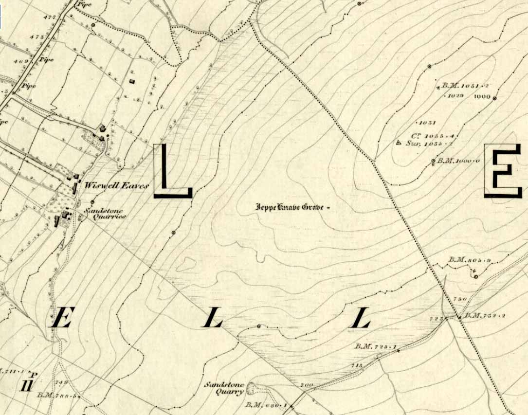
From Sabden, head up the steep Clitheroe Road towards the Nick o’ Pendle, turning left 100 yards before the hilltop and along the dirt-track for a few yards, before veering up the winding footpath to the hilltop. When you’re at the peak of this little bit o’ moorland, go to your left (west), following the small path into the grasses and heather all the way on for a few hundred yards till you hit the triangulation pillar. Go past this, over one stile (north) and then immediately at right-angles (west) over another stile and downhill for about 100 yards until you’re on the rough grassland level. Keep your eyes peeled as you’re walking until you see what looks like a denuded stone-lined pit, much overgrown — with the main feature (showing that you’ve hit the target) being the engraving on one of the larger rocks: “Jeppe Knave Grave”.
Archaeology & History
The Jeppe Knave Grave
First described in early perambulation records of 1326 CE, this is a small but intriguing site found on the far southwestern slopes of Pendle Hill, on the ridge beneath the triangulation pillar of Wiswell Moor. It’s a small and overgrown cairn with a general archaeological association of prehistory attached—though no detailed excavation has ever been done here, despite local archaeologists having access to a large grant to explore this region a short while ago.¹ But up North, as many of us know, archaeology is given little priority and those who do decent exploratory work under the umbrella of such academic quarters tend to be few and far between. Thankfully we had the northern antiquarian and local writer John Dixon (1993) nearby who gave us the best overview of the site. He wrote:
“This landscape feature, known as Jeppe Knave Grave, stands at a place called The Lows high on Wiswell Moor and takes the form of a low grass-covered mound 16M in diameter with a stone filled depression in the centre 5 x 3 M. This feature appears to be a mutilated cairn and has been tentatively ascribed to the Bronze Age. The outer ring of stones can be discerned in the rough pasture at the perimeter – yellow in dry conditions, showing the circular shape. Given the large size of the stones here, the cairn may have been of a chambered type/passage tomb of the Neolithic period, and if this was the case the burial (or burials?) was one of great importance.
“Upon the largest stone are inscribed the words ‘JEPPE KNAVE GRAVE and a cross (inscribed by the Scouting Association in the 1960’s). The stone marks the final resting place of Jeppe Curteys (Geoffrey Curtis), a local robber who was decapitated for his crimes in the first year of Edward III, 1327. The name first occurs in a record of the boundaries between Wiswall and Pendleton dated 1342.
“…In those times the punishment of decapitation was unusual, being reserved for those of noble birth. So who was this Jeppe Curteys, punished by decapitation and later buried on the high ridge of Wiswell Moor in a pre-Christian burial mound on the then boundary of parishes? That intriguing story we may never know. But to be buried in such a manner and place was indeed a great indignity – interment in what might be considered in those times to be a ‘pagan’ or ‘devilish’ spot. It may be that to bury a man in such a place was to literally ‘send him to the devil’. Alternatively one could ask: ‘Was the site thought then to be the burial spot of some noble ancestor, and Jeppe being of possible noble birth interred with great dignity? Again we may never know, yet it is significant that this lonely spot is still identified with a man who was executed 700 years ago.
In 1608 it was stated that one Robert Lowe had taken a stone from the grave and used it as a cover of his lime kiln.”
Old codgers from the local Senile Society, inspecting York Minster!Agatha Lyons’ 1871 sketch
The design of the cairn here is unlike the ones you usually come across on the Lancashire and Yorkshire moorlands. The edges of the Jeppe Knave Grave are walled and much more well-defined than the large rock piles that we find scattering our uplands. A similar though larger cairn with features similar to these can be seen in the large Low Hill tumulus on Elslack Moor near Earby, about ten miles northeast of here…
Other prehistoric remains scatter the many rolling hills that you can see from here: mainly prehistoric tombs sat upon hilltops as far as the eye can see. John pointed out what may be the remains of another tumulus that can be seen on the nearby horizon a few hundred yards NNW from here, overlooking the gorgeous village of Pendleton and the landscape beyond…
References:
Dixon, John, Journeys through Brigantia – volume 9: The Ribble Valley, Aussteiger Publications: Barnoldswick 1993.
Whitaker, Thomas Dunham, An History of the Original Parish of Whalley – volume 2, George Routledge: London 1876.
¹ John Dixon informed us how the people in question spent the grant — somewhere in the region of £50,000 — on exploring some modern architectural features, instead of exploring some of the little-known sites and seeking out others on these hills.
* John is the author of many fine historical travel guides, including the Journeys through Brigantia series. See the titles in the Lancashire Bibliography and Yorkshire Bibliography for a more complete listing of all his books to date. If you wanna buy any of his works, or make enquiries regarding them, email John at: lancashirebooks@fsmail.net – or write to him direct, at: John Dixon, Aussteiger Publications, 21 Lowergate, Clitheroe, Lancashire BB7 1AD.
From Sabden village, walk up the Clitheroe Road towards the hairpin Nick o’ Pendle, but take the turning left 100 yards before the Nick. Walk along the dirt-track for less than 100 yards, watching for the small upright on the right-hand side of the track. You can’t really miss it!
Archaeology & History
The Coffin Stone
To be found on the far southern flanks of Pendle Hill, the Lancashire writer and historian, John Dixon,* brought us to this little-known stone a few days back — and gave us the history of the place. (Dixon 1993) He pointed out how it’s situated right alongside the legendary cross-Pennine prehistoric route that was labelled ‘Rombald’s Way’ by Eric Cowling. (1946): an important trackway which ran from coast to coast, allowing for the passage and transmission of flints, salt and early metals carried for barter and other uses. What may be another standing stone is on the nearby skyline a couple of hundred yards east; and on the slopes either side of here are the prehistoric tombs of Jeppe Knave Grave and the Devil’s Apronful (amongst others). A fine little standing stone!
Folklore
The name derives from it being a place where, in bygone days, when coffins were carried along the ancient routeway hereby, it was rested by this stone. As John Dixon (1993) told:
“It was used to mark a resting point for coffins en route from Pendle Forest to Whalley, allowing the mourners to refresh and pray by the curative Marion well, in a time before the ‘Newchurch’ of St. Mary was established at Goldshaw Booth in 1544.”
…and from another angle
The Marion Well he mentions is more popularly known as Our Lady’s Well and can be found a hundred yards up the hillside above our Coffin Stone. If you walk up the slope you’ll see the site emerging where a small boggy pool appears on the hillside, and the course of the small stream marked by the reeds growing down the grassy slopes. Although it became very much a Roman Catholic practice to venerate the Virgin Mary by this old well, the ritual was of course a much older heathen one.
John has also reminded me to mention “the fossil markings on the side of the stone – some plant from a former age” which you can see curving up from the bottom of the upright.
References:
Cowling, Eric T., Rombald’s Way: A Prehistory of Mid-Wharfedale, William Walker: Otley 1946.
Dixon, John, Journeys through Brigantia – volume 9: The Ribble Valley, Aussteiger Publications: Barnoldswick 1993.
* John is the author of many fine historical travel guides, including the Journeys through Brigantia series. See the titles in the Lancashire Bibliography and Yorkshire Bibliography for a more complete listing of all his books to date. If you wanna buy any of his works, or make enquiries regarding them, email John at: lancashirebooks@fsmail.net – or write to him direct, at: John Dixon, Aussteiger Publications, 21 Lowergate, Clitheroe, Lancashire BB7 1AD.
Many churches strive to find evidence in the greater antiquity of their foundations than the industrial age; and even those whose origins are medieval hope to find much older roots. Such is the case with this Norman church of St. Peter, where just such an antiquity was found in the middle of the 19th century, embedded in the old walling where it had been encased many centuries before. Thought to have been carved around the 8th century, the design on the stone typifies much ‘Celtic’ art, as it tends to be called, such as are found all over northern England. As we can see here, the main feature is a series of curved and interlocking lines covering most of the rock face (sadly, no swastika occurs on this stone, but it’s common on many others of this period). The old vicar of the church — Harold Rogers — takes up the story:
“About the year 1841, when part of the chancel work was taken down, some fragments of curiously ornamented sandstone were discovered embedded in the masonry. They were carefully removed, put together, and placed in the churchyard where, protected from injury by a glass case, they may now be seen. The carved ornamentation on this ancient relic was probably executed about the 8th century, and it is conjectured that the stone formed part of a cross placed there by some early Saxon converts…to commemorate the spot where the gospel was first preached in this locality.”
A brass inscription attached to the encased carved stone informs the visitor the same information. The proximity of this early carved stone to the River Bollin and, very probably, an ancient ford crossing, implies the waters here were held as sacred in ancient days and hence the supplanting of the ornate carved cross at this position in the landscape.
References:
Rogers, Harold W., Prestbury and its Ancient Church, Arthur Clownes: Macclesfield n.d. (c.1960)
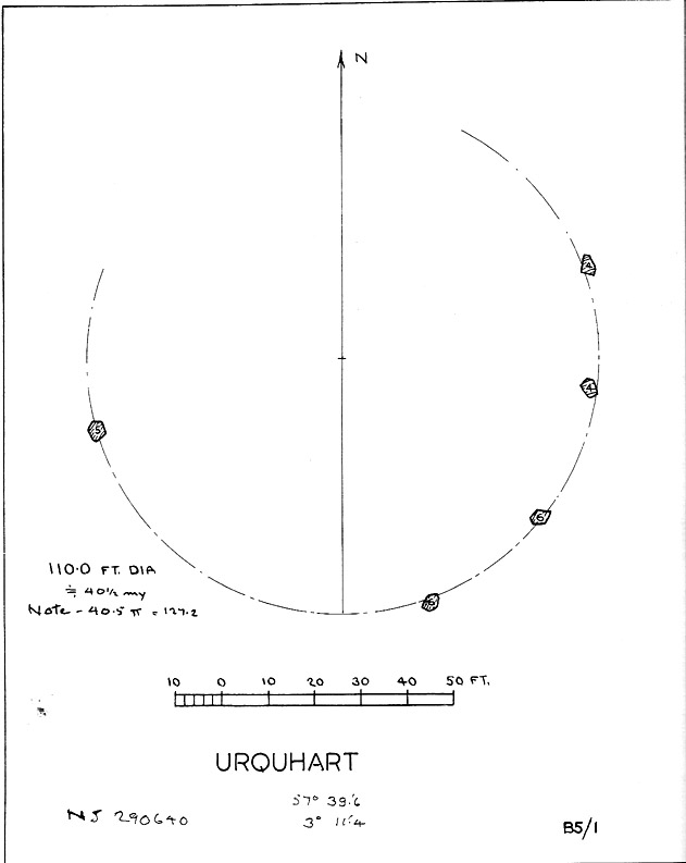
Described in early local history journals, this stone circle of many names is composed of mainly small upright stones — though one of them stands nearly six feet tall — yet it has quite a large diameter of 110 feet (or 40.4 megalithic yards). Alexander Thom (1980) measured its circumference as being precisely 127 megalithic yards. It is thought to have originally consisted of twelve stones, but today only five remain. And in a landscape where recumbent stone circles reign supreme, Aubrey Burl (in Thom, Thom & Burl 1980) thought the lay-out of the site suggestive of just such a monument, saying:
“The apparent grading of the stones towards the S-SSW and the 19th century reference by the Minister of Urquhart to “nine tall stones in a circle, two of them at the entrance to the altar” suggest that this may have been a recumbent stone circle, from which the recumbent and its flankers have subsequently been removed. It is noteworthy that the westernmost stone has several small cupmarks on it, a pillar which would have been close to the recumbent in that restricted area where cupmarks are to be found in recumbent stone circles.”
A singular TNA profile entry of the said cup-marked stone will be added in due course. The middle of the circle was dug sometime prior to 1870, but no human or other remains were found.
Folklore
Described by two local ministers as ‘Nine Stanes’ back in Victorian days, with at least one of the stones being recumbent, it was the great Fred Coles (1906) in one of his many articles on the megalithic remains of Scotland who narrated the following tale, told to him first-hand by a local man called Mr T. Geddie, after some of the standing stones from this circle were removed in the nineteenth century.
“One of the stones,” wrote Mr Geddie, “was to be taken away to be built into a new steading at Viewfield. Mr Brown thinks this was prior to the building of the Innesmill steading, which dates from 1843. No sooner had the Stone been deposited in the toon, however, than uncanny signs and omens began to manifest themselves, and it was resolved to get rid of it. While it was being taken back to its original position, the horse stuck or fell when taking a somewhat steep little brae, and the Stone was taken no further, but buried where it was. The spot it about 80 or 100 yards from the circle.”
Grinsell (1976) also tells the tale that if you visit the circle at midnight and walk round the circle three times, the devil can appear.
References:
Coles, F.R., ‘Report on Stone Circles Surveyed in the North-East of Scotland, Chiefly in Banffshire’, in PSAS 40, 1906.
Grinsell, Leslie V., Folklore of Prehistoric Sites in Britain, David & Charles: London 1976.
Thom, A., Thom, A.S. & Burl, Aubrey, Megalithic Rings, BAR 81: Oxford 1980.
Crowned by a clump of trees (planted in 1740), this hilltop site is one of the more impressive of a number of tombs hereby, with its nearest other neighbour being 70 yards southeast of here. One of Dorset’s early tribal meeting places (Anderson 1934), the tomb was illustrated on Isaac Taylor’s 1765 map of the region and was dug into in 1858 “on the orders of a local magnate” (Marsden 1999), damaging some substantial portion of the tomb. Of this, craniologist and antiquarian John Thurnam was most displeased; for in his description of the opening of Culliford Tree he wrote:
“A wide trench had been dug through it one side, from the summit and the rubble which had been thrown out had not been replaced… Another subject of regret was the fact that though, as we were told by the neighbouring rustics, human remains, with pottery and certain other relics, were found in the barrow, no authentic account of the exploration had, so far as we could learn, been put to print.”
Leslie Grinsell (1959) found the same trouble in his assessment of this site; and the Royal Commission (1970) lads could only describe the site thus:
“Large trench on south and top almost certainly dug in 1858 when four secondary extended inhumations, one with necklace of amber and two gold-plated beads, and cremation with incense cup in collared urn, were found.”
However, it seems that the necklace and gold-plated beads have been “lost” — i.e., someone has them in their own private collection somewhere!
Folklore
This is one of very few tombs in this part of the country where we find the tradition of fairy music. Grinsell (1959) told that:
“The Culliford Tree barrow, formerly the meeting place of the Hundred of Culllingford Tree, is also known as the Music Barrow from the belief that music could be heard beneath the mound by those who listened at the apex at midday.”
References:
Anderson, O.S., The English Hundred-Names, Lunds Universitets Arsskrift 1934.
Marsden, Barry M., The Early Barrow Diggers, Tempus: Stroud 1999.
Royal Commission on Historical Monuments, An Inventory of Historical Monuments in the County of Dorset – Volume 2: South-East, Part 3, HMSO: London 1970.
Warne, Charles, Celtic Tumuli of Dorset: An Account of Personal and other Researches in the Sepulchral Mounds of the Durotriges, Smith: London 1866.


")
")


")
")