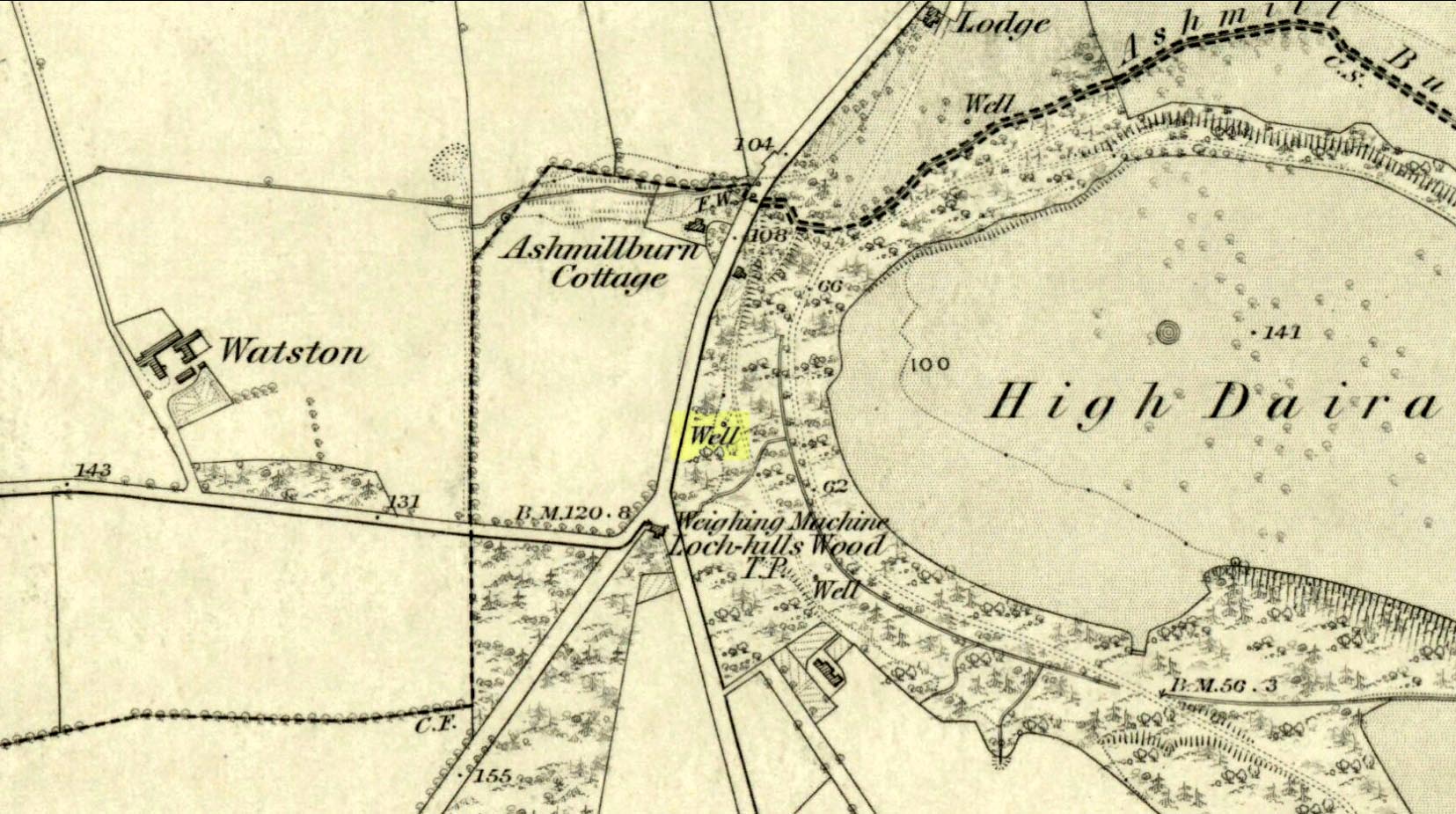
This takes some finding! From the village of Doune take the A84 road towards Stirling and, just over the bridge barely 100 yards along, on your left, walk down the track past the old lodge house. 350 yards along, up the slope on your right where young trees and an excess of boscage prevails, walk up through it until, about 10 yards below an overgrown path at the top, beneath a raised section of old stonework, an old pipe protrudes from the undergrowth. The small spring of water that emerges 10 yards beneath this, amidst the brambles and reeds, is what you’re looking for.
Archaeology & History
Wells named ‘Ellen’ usually have a long and sacred history behind them, but this one seems unusually silent. Apart from being shown on the 1866 OS-map—simply as a ‘Well’—it is only mentioned briefly in Mr Mackay’s (1953) survey of Doune, being not far from the Clans Well, and in his day it was “still in use.” But not anymore! The water is barely running, but the trickle that still exists is nice and clear and it tastes good. It’s seen much better days though….
‘Ellen’s Wells’ tend to have one of three origins, being either 1) dedicated to St Helen, whose festival date is August 18; (2) named after or dedicated to the Elder tree (Sambucus niger); or, (3) named after a local person of this name. At some wells it may be two of these elements with their relative mythologies complimenting each other, overlapping between heathen peasant lore and early christian folklore. This has been the case at a number of St Helen’s Wells I’ve surveyed in Yorkshire and Lancashire. At this site however, there are no remaining Elder trees, meaning that its name relates to one of the two other options; but without any extant historical references to St. Helen hereby, we must conclude that at some point in the dim and distant past, a local lady called Ellen found her name immortalized in this all-but-forgotten sweet spring.
Out of Aberfeldy, take the A826 road as if you’re going up Glen Cochill. Not far up, just where the housing of Aberfeldy itself ends and the green fields open up either side of you, keep on the road for a half-mile where you meet a small copse of trees on your left, with a dirt-track that runs down the slope. Go along the track for 0.8 miles (1.3km), past the Ursa Major Stone and where the track splits, go left past the Quartz Stone and follow the track through the farmyard. It’s somewhere there – or is supposed to be!
Archaeology & History
On our visit here, we couldn’t locate the cup-and-ring stone that’s described in Sonia Yellowlee’s (2004) regional rock art survey. She described it, as archaeologists always do, in the briefest manner, telling us simply:
“Leaning against a pile of rubble in the farmyard there is a split boulder bearing eighteen cupmarks, one of which is ringed.”
It may have been destroyed, as we were told by a couple of locals that there used to be “a real miserable sod” living there. When we visited the place and tried to ask the present farm owner, sadly he wasn’t to be found. If any rock art explorer manages to locate this seemingly lost cup-and-ring, please let us know – and mebbe send us some photos so that we can add them to this site profile. 😉
References:
Yellowlees, Sonia, Cupmarked Stones in Strathtay, RCHAMS 2004.
Acknowledgements: Big thanks to the crew – this time being Neens Harris, Paul Hornby & Frank Mercer. And the stunning resource of Scotland’s 1st edition OS-maps is Reproduced with the kind permission of the National Library of Scotland.
Out of Aberfeldy, take the A826 road as if you’re going up Glen Cochill. Not far up, just where the housing of Aberfeldy itself ends and the green fields open up either side of you, keep on the road for a half-mile where you meet a small copse of trees on your left, with a dirt-track that runs down the slope. Go down here and follow the slightly meandering track for 0.8 miles (1.3km), a short distance past the Ursa Major Stone where the track splits. Take the track to the left and there, less than 100 yards on you’ll hit a large boulder on your left. That’s it!
Archaeology & History
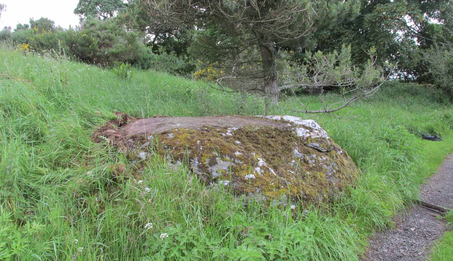
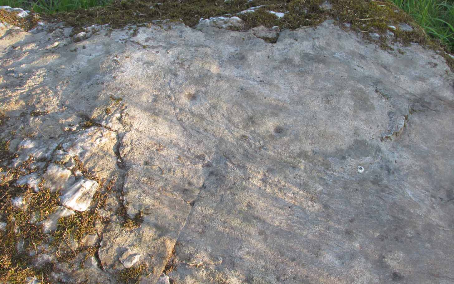
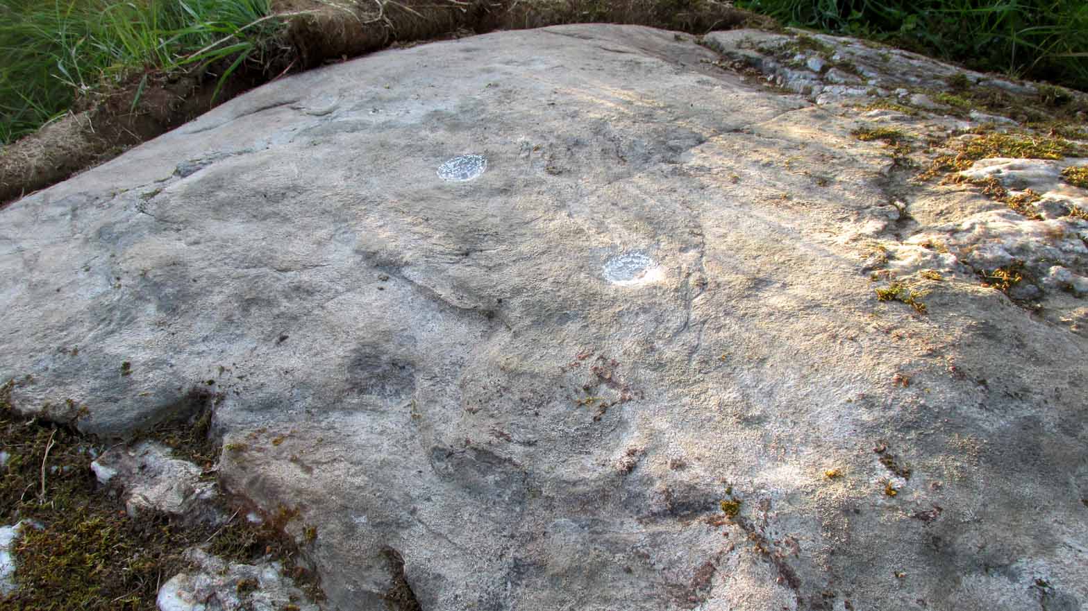
Not previously recorded, this simple cup-marked stone will probably only be of interest to petroglyph aficionados, or those folk who are into ‘energies’ at sites. This latter aspect is due entirely to the carving being etched onto a huge rock, much of which is composed of quartz—which isn’t too unusual in this part of the world. But that aside…
Looking down at the cupsThe cupmarks highlighted
It is one in a group of carvings within a few hundred yards of each other, with its nearest neighbour 20 yards to the north. That one’s covered in cups—but on this large Quartz Stone, only two of them exist, on the top near the centre. Just a couple of inches across and half-an-inch deep, they’re pretty clear once you see them. The raised piece of ground behind the stone is artificial and has variously been described by antiquarians and archaeologist alike, as either a prehistoric dun, or a stone circle. Whatever it may be, some of it is certainly man-made. Check it out – and mebbe ask the friendly fat fella who lives nearby and what he thinks.
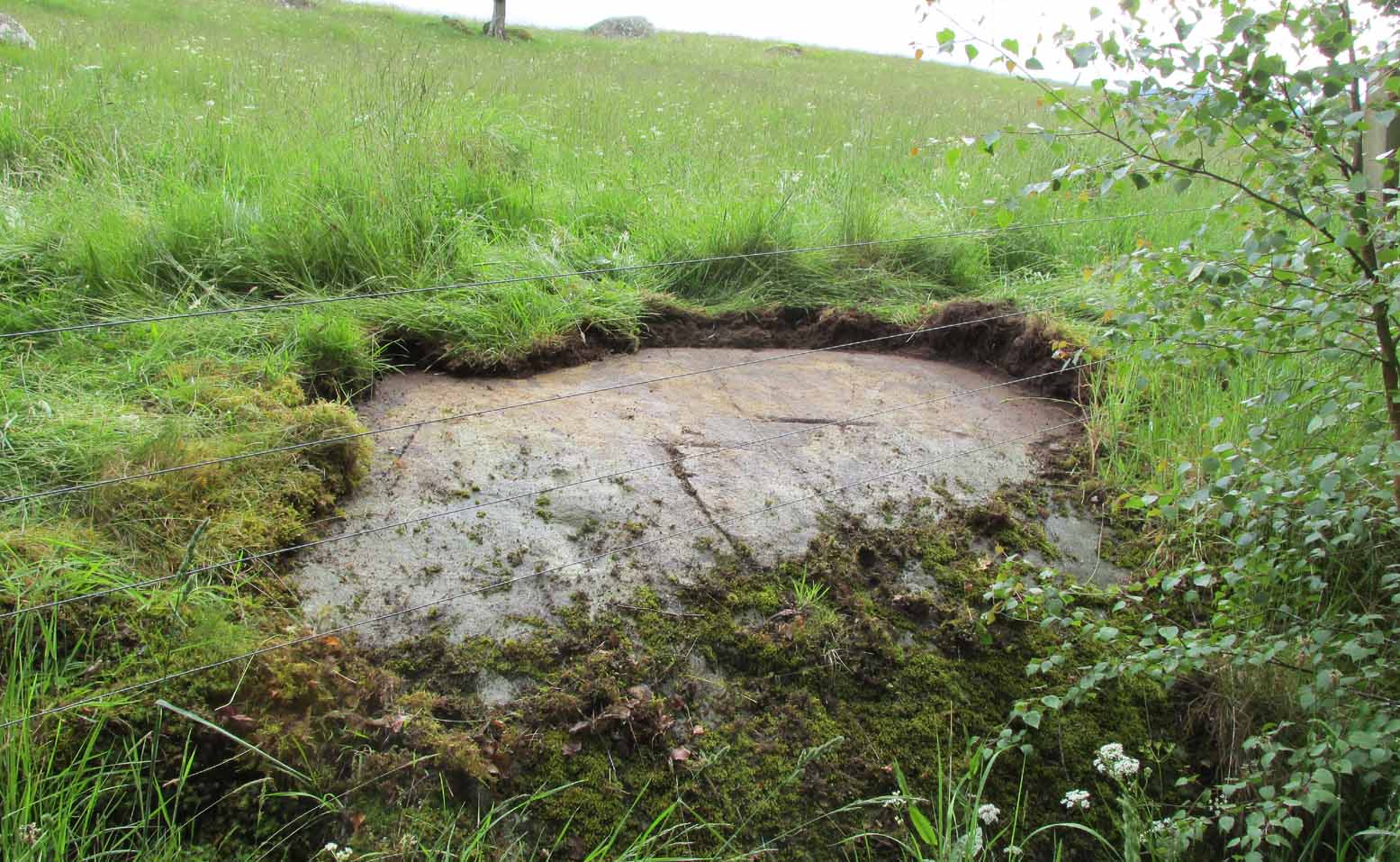
Out of Aberfeldy, take the A826 road as if you’re going up Glen Cochill. Not far up, just where the housing of Aberfeldy itself ends and the green fields open up either side of you, keep on the road for a half-mile where you meet a small copse of trees on your left, with a dirt-track that runs down the slope. Go down the track, bending to the right, then the left and then on for a quarter of a mile until the lines of trees appear either side of you. Barely 200 yards along, the track swerves slowly to your right, and the field above you slopes uphill. Keep your eyes peeled at the fencing on your right and you’ll see a stone sloping towards you right by the fence with faint cup-marks on it. You’ll find it!
Archaeology & History
A truly fascinating cup-marked stone recently uncovered by Paul Hornby on another one of our TNA meanderings. Fascinating because of the curious arrangement of the cups on the stone. Often, cup-marked stones have little to interest the causal visitor – but this one’s different. As can be seen quite clearly, the cups are arranged in the shape of the constellation of the Great Bear, or Ursa Major – albeit with an extra ‘star’ in this design. But it’s damn close! In all likelihood (he says with his sceptical head on 😉 ), the design is fortuitous when it comes to the Ursa Major. I know from many years experience how easy it is to see meaningful shapes and designs in the almost entirely abstract British petroglyphs, but the design is very close to the constellation we all got to know when we were kids.
Looking along the stoneGazing down at Ursa Major
The stone itself slopes upwards at an angle of about 60º, before starting to level out as it rises. All of the cup-marks have been pecked onto this sloping surface (the vast majority of carvings are found on top of stones). Altogether, at least twelve faint and shallow cups were exposed when we looked at it—measuring the usual inch to inch-and-half across—but it is likely that more of them are hidden beneath the turf at the top of the stone. We could discern no rings or other features in the design.
This is just one carving amidst a good cluster of petroglyphs within a few hundred yards of each other (the Quartz Stone being one of the nearest) that are well worth checking out if you like your rock art. It may also be of interest to astronomy students, or those exploring archaeo-astronomy.
References:
Yellowlees, Sonia, Cupmarked Stones in Strathtay, RCHAMS 2004.
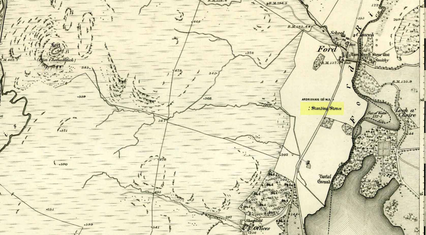
Unless you’re venturing down the tiny Loch Awe roads, the easiest way here is to turn right off the A816 Lochgilphead-Oban road, 1½ miles north of Kilmartin. Go along this winding minor road for literally 2½ miles where, after coming out the tree-lined road, just past the small Loch Ederline, the fields re-appear on both sides of the road. Just here, where the trees end, just a few hundred yards before the hamlet of Ford, in one of the field on the left, you’ll see a tall upright stone. That’s it!
Archaeology & History
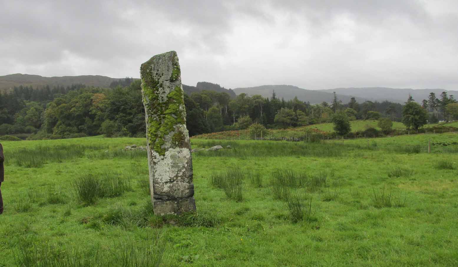
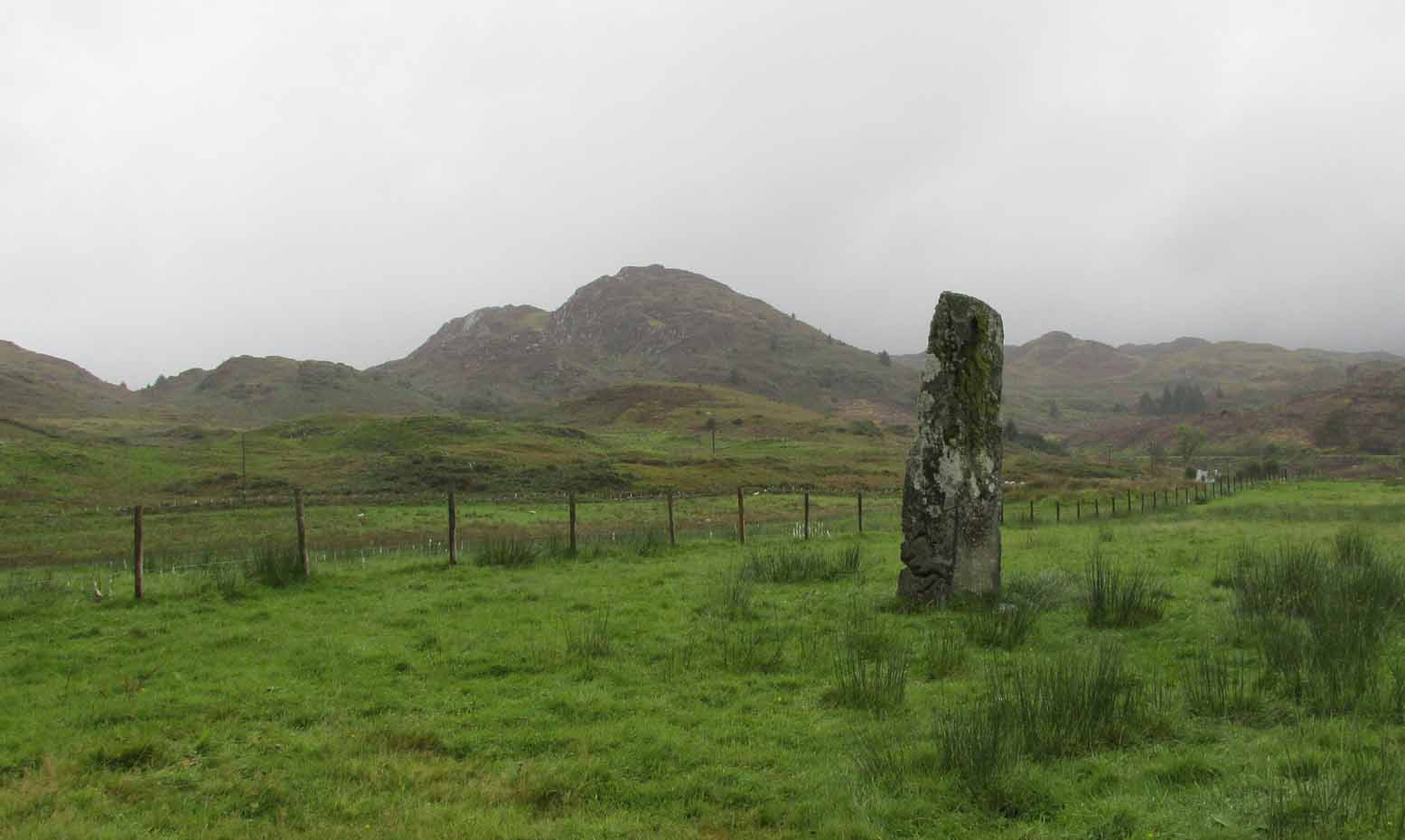
I was very fortunate, many years ago, to live in the old farmhouse of Auchinellan in the trees by this ancient stone. It became a companion of mine many-a-time, as I sat with it in rain and mist and darkness sometimes, beneath the bright Moon. It always had a good feeling about it. And so when a small bunch of us visited here again recently, it was almost as if I’d never been away. Tis a magickal part of our landscape.
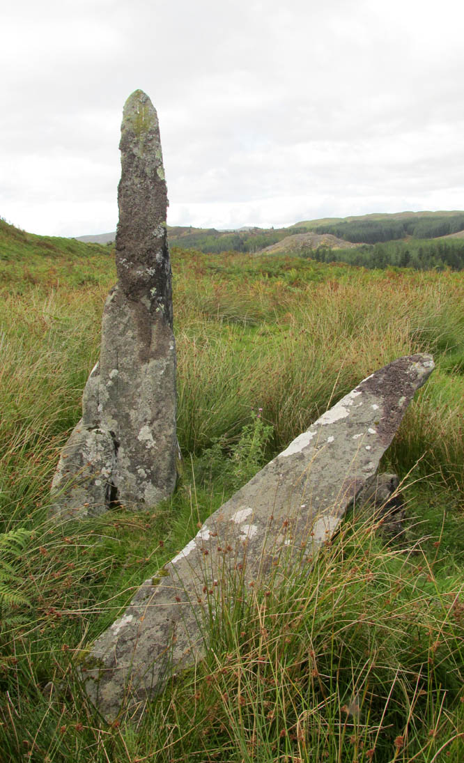
The old stone looking NThe old stone looking NW
Standing ten-foot-tall on a grassy plain with craggy hills all round, this old fella once had a companion close by its side—a stone one! Accounts of it are curious to say the least, with one telling us that it was only “a few inches high” – which is just daft. The now-lost stone was in fact about six-feet tall and the story of its disappearance was that it was moved into the grounds of Auchinellan House where I used to live, somewhere in the garden. I could never find it, and local folk told me that the old fella who lived in the mansion would have known about it, but died shortly before I moved in. Clive Ruggles (1984) told that it could be found at grid-reference NM 8653 0268, but that would be smack bang on the manor house.
As far as I can tell, the first written testimony of this stone was by the Ordnance Survey lads after they’d visited here in 1871 and, several years later, highlighted it on their maps. (above) On this is clearly shown, just yards apart, the two standing stones. Much later, when the Royal Commission (1988) doods did their survey, they described the stone in their usual brief way:
“Situated on the top of a slight rise in a pasture field 270m SW of the Ford Hotel, there is a standing stone which measures 0.7m by 0.55m at the base and rises with straight sides to a flat top at a height of 3m…”
The site was included in Thom’s (1990) major survey on prehistoric stone rows where, again, only a brief description is given, saying:
“On a terrace near Loch Ederline is a standing stone which leans to the E. It is 9ft 6 (2.9m) high.”
It’s a beautiful place in a beautiful setting and is one of countless prehistoric monuments in this part of Scotland. Well worth having a look at.
Folklore
The Gaelic names for this site—Achnacarra and Achadh nan Carradh—means “the field of the burial stone”, which relates to the folklore of the stones reputedly marking the place of an ancient grave.
Campbell, Marion & Sandeman, M., “Mid Argyll: An Archaeological Survey,” in Proceedings Society of Antiquaries Scotland, volume 95, 1964.
Royal Commission on the Ancient & Historical Monuments of Scotland, Argyll – Volume 6: Mid-Argyll and Cowal, HMSO: Edinburgh 1988.
Ruggles, Clive L.N., Megalithic Astronomy, BAR: Oxford 1984.
Thom, Alexander, Thom, A.S. & Burl, Aubrey, Stone Rows and Standing Stones – volume 1, BAR: Oxford 1990.
Acknowledgements: Big thanks to Neens Harris, Paul Hornby & Frank Mercer. And the stunning resource of Scotland’s 1st edition OS-maps is Reproduced with the kind permission of the National Library of Scotland.
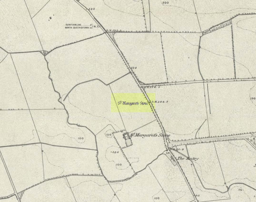
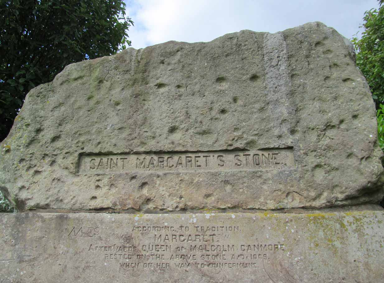
Take the A823 road out of Dunfermline south towards Rosyth. A half-mile before you hit the motorway roundabout, at the roundabout where Carnegie Avenue takes you east, turn west and park up along the road where the modern business park lives. 30-40 yards from the roundabout, set back on the pavement, you can’t really miss the huge flat slab of stone, covered in cup-markings, resting on a stone plinth with ‘St Margaret’s Stone’ stamped on it!
Archaeology & History
On the 1856 OS-map of this area, St Margaret’s Stone is shown at the roadside just above a farm of the same name, a short distance away from its present location. In October 1879, Alexander Stewart (1889) told us that funds were raised and steps taken to properly fix and preserve this ancient ‘resting-place’ of Queen Margaret on the Queensferry Road. It was quite a few years later before it was moved the few hundred yards further to its present location.
Cups on stone’s edge
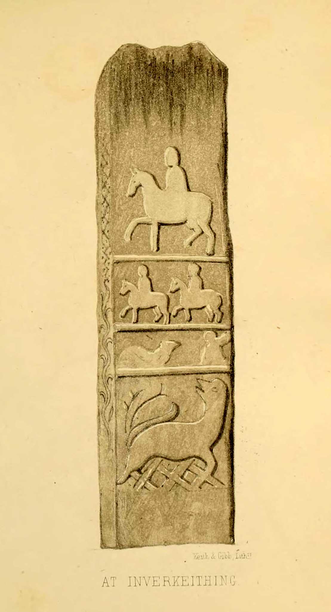
Early writers tell us that originally its position in the landscape was on the crest of one of the rises in the land between Dunfermline and the sea, making it visible for some considerable distance. This would seem to have been a deliberate placement. In my mind, and in accordance with the placement of many a prehistoric tomb, St Margaret’s Stone may originally have been part of a neolithic or Bronze age cairn, long since gone. The size and shape of the rock implies it too, with similarities here of the impressive cist or gravestone found inside the Netherlargie North cairn at Kilmartin. However, this wasn’t the thought of the prodigious Scottish historian, William Skene. He thought that St Margaret’s Stone originally stood upright, being a Pictish-style standing stone that was mentioned in the first Statistical Account of the area. The brilliant Scottish antiquarian, John Stuart (1856)—who gave us an illustration of the ‘standing stone’ in question—told us:
“It has been supposed by some that “St. Margaret’s Stone,” a block now lying on the side of the highway leading from Inverkeithing to Dunfermline, and about midway between these places, can be identified with the standing stone referred to in the Statistical Account. Mr Skene has noted below a sketch of St. Margaret’s Stone:- “The sculpture upon this stone has been lately chipped off in mere wantonness, so as to leave few traces of the subject recorded upon it.” He farther states that it formerly stood erect, and was called “The Standing Stone.” According to Mr. Skene’s measurement, St. Margaret’s stone is about nine feet and a half in length, one foot in thickness, and four feet broad at the widest end, and broken off to a narrow point at the other.”
The missing ‘standing stone’
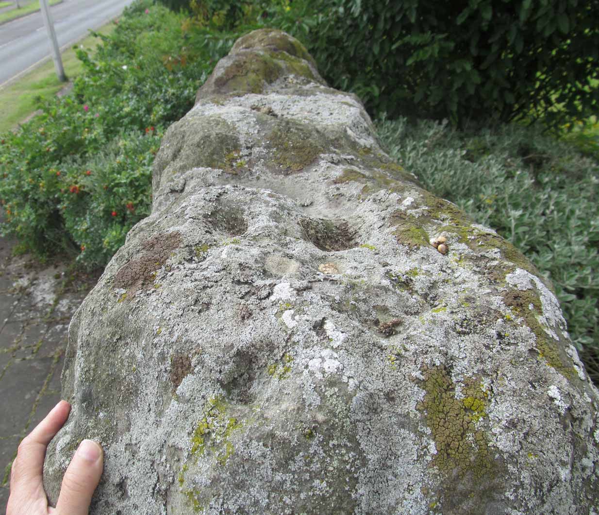
In this instance, Skene was confusing St Margaret’s Stone with the lost Pictish monolith (left) that used to exist nearby, which had carved horse figures and other memorial designs upon it and which he thought had faded away. Whereas the large slab we are looking at here, and which Skene visited and measured, is covered on one side by a gathering of prehistoric cup-markings—much earlier than any Pictish or early christian carvings. At first glance, it seems that some of these cups may well be natural, but it has to be said that some of them are distinctly man-made. And if we were to believe the archaeo-accounts of the stone, the cupmarks are only to found on one side of the stone. This is incorrect. As we can see here, a number of cupmarks run along the edge of the stone. We cannot say for sure whether all of them are artificial, but they certainly look like it! Also, on the other side of the flat surface, one or two single cups are visible. It would be good if we could get an artist to give us a detailed impression of the prehistoric carvings without the modern engraving of St Margaret’s Stone etching on the main face. (is there anybody out there!?)
The Royal Commission (1933) lads visited the stone in 1925 and, several years later in their write-up, told us simply:
“This stone…stands with its main axis due north and south and measures 8 feet 6 inches, by 4 feet 7 inches, by 1 foot 6 inches. On one side the entire surface is cup-marked, the markings varying in size from 1¼ inches to 3¼ inches and having an average depth of from ½ to ¾ inch.”
When the Scottish petroglyph writer and explorer, Ron Morris (1968) came to the site, he gave it an equally brief description, merely telling us:
“On standing stone (8 1/2 feet high, 4 1/2 feet wide), built in to roadside fence, over 80 cups, up to 4in in diam, 3/4in deep, some run together as rough dumbells.”
It’s well worth checking out!
Folklore
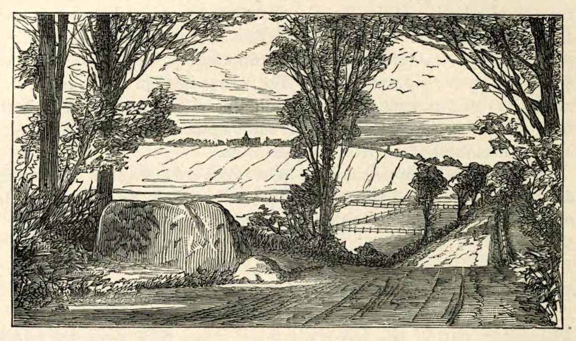
St Margarets Stone in 1825
When the Saxon Queen Margaret landed on the shores just west of Queensferry at Rosyth Castle (NT 1087 8200), legend reputes that she and her entourage made Her way north towards Dunfermline. Halfway along the ancient track She rested at this large stone which, thereafter, gained the name by which we know it today. It was said that Queen Margaret subsequently visited the stone on a regular basis for periods of solitude. The tale probably has some germ of true in it. Additional ingredients also told that,
“The large stone here is associated with St Margaret and was visited by women who hoped to conceive or sought a successful birth. The eight-foot high stone is said to mark the resting place of St Margaret when she journeyed between Queensferry and Dunfermline. Margaret had eight successful pregnancies and probably needed to rest quite a few times on her travels!”
The fertility aspects of the rock were not the only pre-christian virtues attached to it. We also find that oft-cited motif of rocks moving of their own accord: in this case, as J.B. MacKie (1905) told us, local people had always
“been told that the stone rose from its bed and whirled thrice round in the air every time it heard the cock at the adjoining farm crow.”
Cocks crowing are symbolic of sunrise, obviously, and this lore may simply represent a folk memory of the spirit in/of the stone being animated at that time of day. It’s a motif found at ancient sites all over the place!
Royal Commission Ancient & Historical Monuments of Scotland, Inventory of Monuments and Constructions in the Counties of Fife, Kinross, and Clackmannan. HMSO: Edinburgh 1933.
Rupert-Jone, John A., Rosyth, A. Romanes: Dunfermline 1917.
Stewart, Alexander, Reminiscences of Dunfermline and Neighbourhood, Scott Ferguson: Edinburgh 1889.
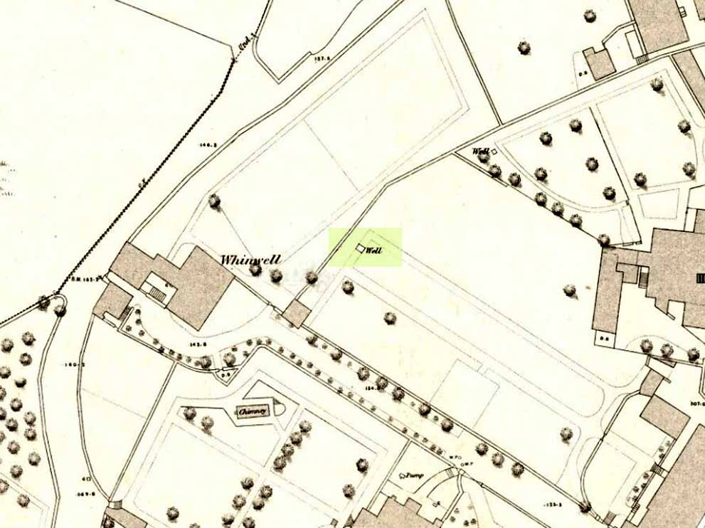
Healing Well (lost): OS Grid Reference – NS 7934 9412
Whin Well on 1858 map
Archaeology & History
Shown on the 1858 map of the city, this ‘Well of the Gorse’ (from the old folk-name ‘whin’, or Ulex Europareus) on the northern side of the old town, about 300 yards east of Stirling Castle, has long since gone. An old cottage of the same name was once to be found at the end of the appropriately named Whinwell Road, which also preserves its memory. Although the folklore of the site has seemingly been forgotten, it may be that the waters here had medicinal qualities akin to those given by the plant – i.e., jaundice, intestinal problems and to strengthen the heart. (see Mrs Grieve’s Modern Herbal)
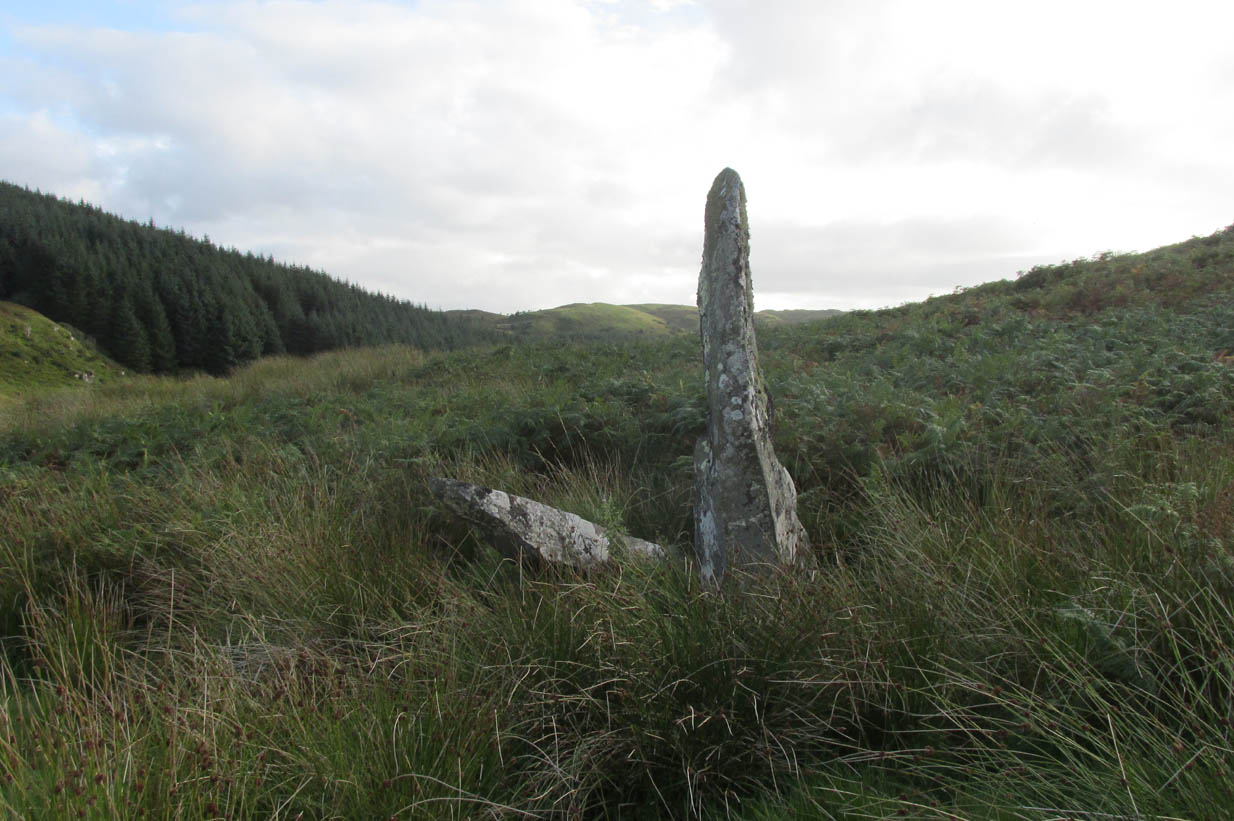
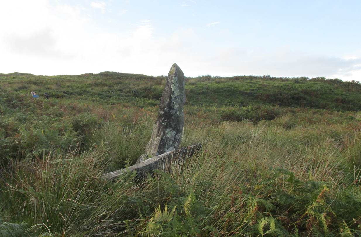
Roughly halfway between the staggering standing stone at Kintraw and the farmhouse of Salachary a coupla miles east along the A816 road to Kilmartin, a small overgrown car park nearly hides on the south-side of the road, just below the forestry. 50 yards west of this, a small track winds uphill. 650 yards (0.6km) up here, once it levels out, a hairpin in the track veers NW; ignore it, instead walking into the marshy grass in front of you (south) for 50-60 yards up and round the small rocky crag. Once you get round the edge of this, immediately east, you’ll see one of the tall monoliths 50 yards ahead of you.
Archaeology & History
Rediscovered in recent times by Marion Campbell (1962), this damaged row of three tall standing stones is cited in Swarbrick’s (2012) poorly-arranged survey as being “difficult to find in broken ground”; although patience brings the stones clearly into sight for any explorer. They’re big too! Sadly only one of them still remains fully upright—but that one’s nearly 9 feet tall!
In Miss Campbell’s initial description of the site, following their rediscovery, she told how,
“A chance sighting led to the discovery of a group of three monoliths, one erect, one sloping and one prostrate, on the West side of a wide glen leading S from the upper part of the Bealach Mor; the site commands a fine view into the northern hills. The spot is about 550ft above sea level and this is therefore the highest group of standing stones so far recorded in the area.
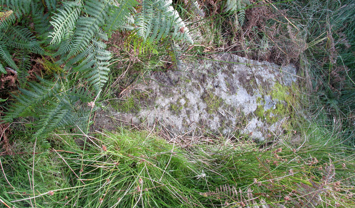
“The erect stone is 8ft 4in x 2ft x 1 ft, lozenge-shaped in section, with a pointed top. The leaning stone, also lozenge-shaped, is 10ft x 1ft 8in x 1ft, and pointed. The fallen stone is over 11ft x 2ft wide, too deeply buried in turf for the thickness to he measured. The stones appear to have stood in line, the nearest points of the first and third stones 9ft apart and the line joining them running north and south. Along a ridge running S behind the stones are a number of small ruins, oval and rectangular, in old cultivations. No surviving placename has been recovered for the site so far.”
Section of the fallen stoneLooking west
Indeed, no subsequent investigation has led to either an early name nor any traditions about the site, and the stones cannot be found on any early maps of the area. A pity, as they’re quite impressive stones and would have had some old stories known of them in ages gone by.
Twenty years after Miss Campbell’s discovery, in May 1982, the stones were visited and surveyed by the Royal Commission lads. Their description very much tallied with Miss Campbell’s, but it’s worth citing anyway. They told us that:
“On a terrace on the W side of an unnamed valley to the S of Bealach Mor and about 850m SW of Salachary, there is a setting of three large standing stones which is aligned from N to S. Only the N stone is still upright; it measures 0.7m by 0.72m at the base and rises with straight sides to a pointed top at a height of 2.75m. The central stone is of similar proportions, but it now leans to the NE at an angle of about 15° to the horizontal. The S stone, which measures 3.4m by 0.65m has fallen with its top to the SE.”
Royal Commission planAlexander Thom’s plan
Around the same time, Clive Ruggles (1984) assessed the Salachary stones for any potential astronomical alignments and found—as Alexander Thom & Aubrey Burl did in their own survey (1990)—that as they pointed virtually north-south they stood beyond any solar or lunar functions. Thom found the stones align almost perfectly north-south, with a notch in the southern horizon at 178°, and on the northern horizon the hilltop of Meall Reamhar at 2° west of north. This northern line may relate to the airt of death, although no other immediate archaeological remains have been found to fortify this idea (however, other unrecorded standing stones are close by and their relationship with Salachary has yet to be adequately assessed).
Aubrey Burl’s first description of this stone row told us:
“There are three stones in a N-S row situated on a terrace on the W side of a glen. The N stone, with a pointed top, stands 8ft 4 (2.5m) high. The central stone leans dramatically at 20°. It is 10ft (3m) in length. The S stone is prostrate and half-buried. It is 11ft (3.4m) long. The row is about 13ft (4m) long. From the site there is a fine view of the northern hills.”
Looking north
In truth, the main north-south axis relates to the more open geological avenue of the landscape. Both the east and west are all but blocked by crags and hills, and the stones seem to have been positioned to echo the hollowed section of the landscape. The land runs in curious geological folds and has a distinct genius loci which I enjoyed in differing (usually wet) conditions when I used to live nearby. The site is well worth a walkabout if you’re in the area – and there are more unrecorded stones still hiding in Nature’s rocky folds nearby.
References:
Burl, Aubrey, From Carnac to Callanish, Yale University Press 1993.
Campbell, M. & Sandeman, M., “Mid Argyll: An Archaeological Survey,” in Proceedings Society Antiquaries Scotland, volume 95, 1964.
Campbell, Marian, ‘Salachary, Kintraw’, in Discovery & Excavation Scotland, 1962.
Ferguson, Lesley, “A Catalogue of the Alexander Thom Archive Held in the National Monuments Record of Scotland,” in Records in Stone (ed. C. Ruggles), Cambridge University Press 1988.
Royal Commission on the Ancient & Historical Monuments of Scotland, Argyll – volume 6: Mid-Argyll and Cowal, HMSO: Edinburgh 1988.
Ruggles, Clive L.N., Megalithic Astronomy, BAR: Oxford 1984.
Ruggles, Clive L.N., “The Stone Alignments of Argyll,” in Records in Stone (ed. C. Ruggles), Cambridge University Press 1988.
Swarbrick, Olaf, A Gazetteer of Prehistoric Standing Stones in Great Britain, BAR: Oxford 2012.
Thom, A., Thom, A.S. & Burl, Aubrey, Stone Rows and Standing Stones – volume 1, BAR: Oxford 1990.
Weston, Garth, Monuments and Mountains, Ashridge: Bakewell 2007.
Acknowledgements: This site profile could not have been written without the help and of Nina Harris, Paul Hornby, Frank Mercer and Belinda Sales.
The quickest way here is bedevilled with troublesome parking (and an unhelpful local at Malling Cottage). That aside, roughly halfway along the A81 between the Braeval roundabout (near Aberfolye) and Port of Meneith, turn down the track at Malling, following it round for 300 yards through the farm, then another 500 yards or so until you reach a junction with a gate on your left. Walk down the track to your right, roughly alongside the Lake of Menteith, for nearly 700 yards until you reach the gate into the forestry commission land. Go thru the gate and turn immediate right, following the fence for about 200 yards where a clump of stones lives. You’re there!
Archaeology & History
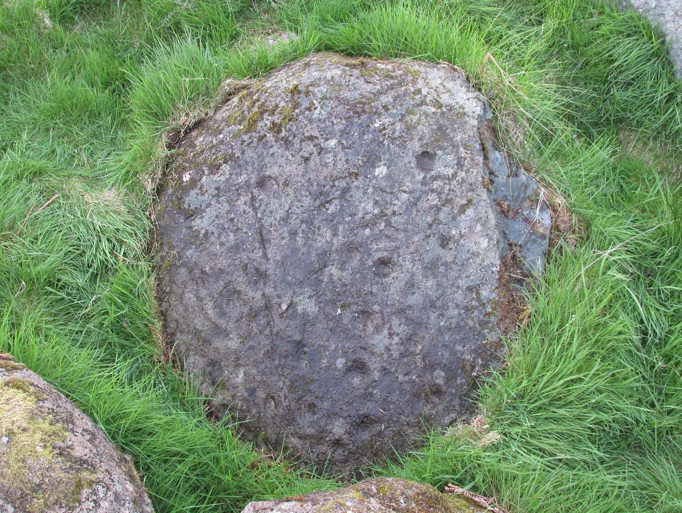
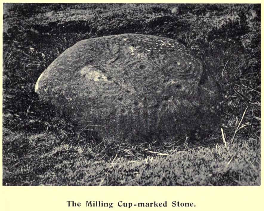
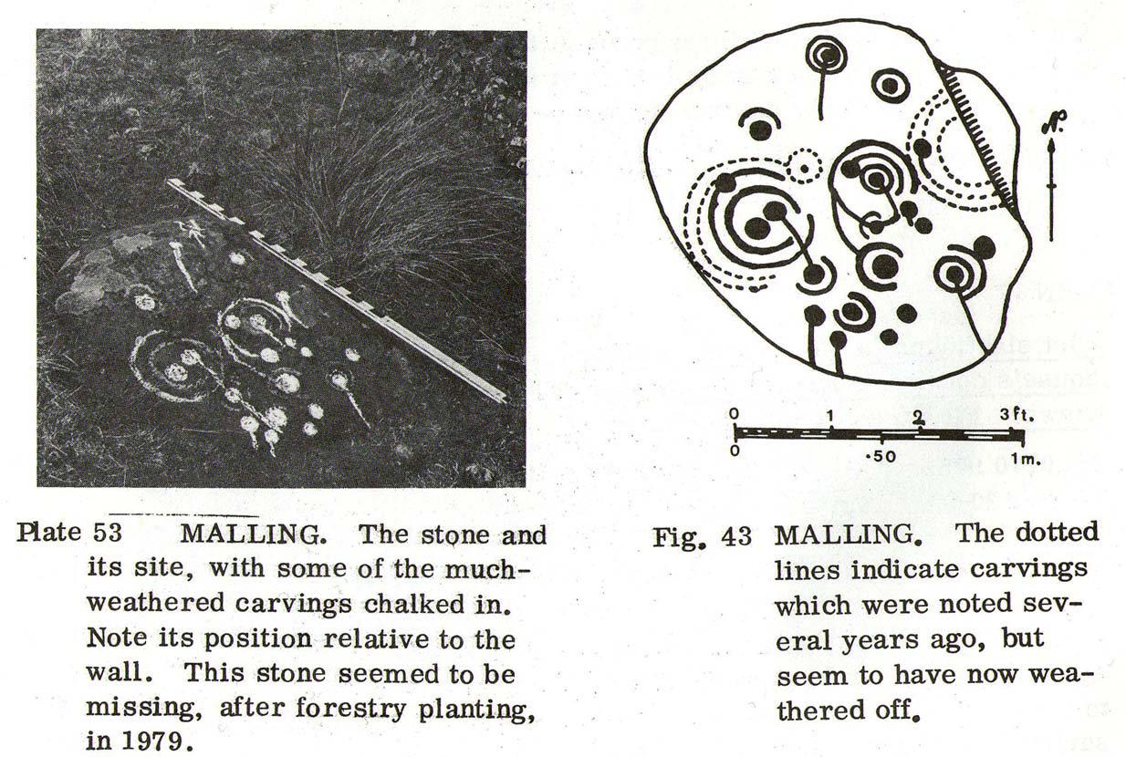
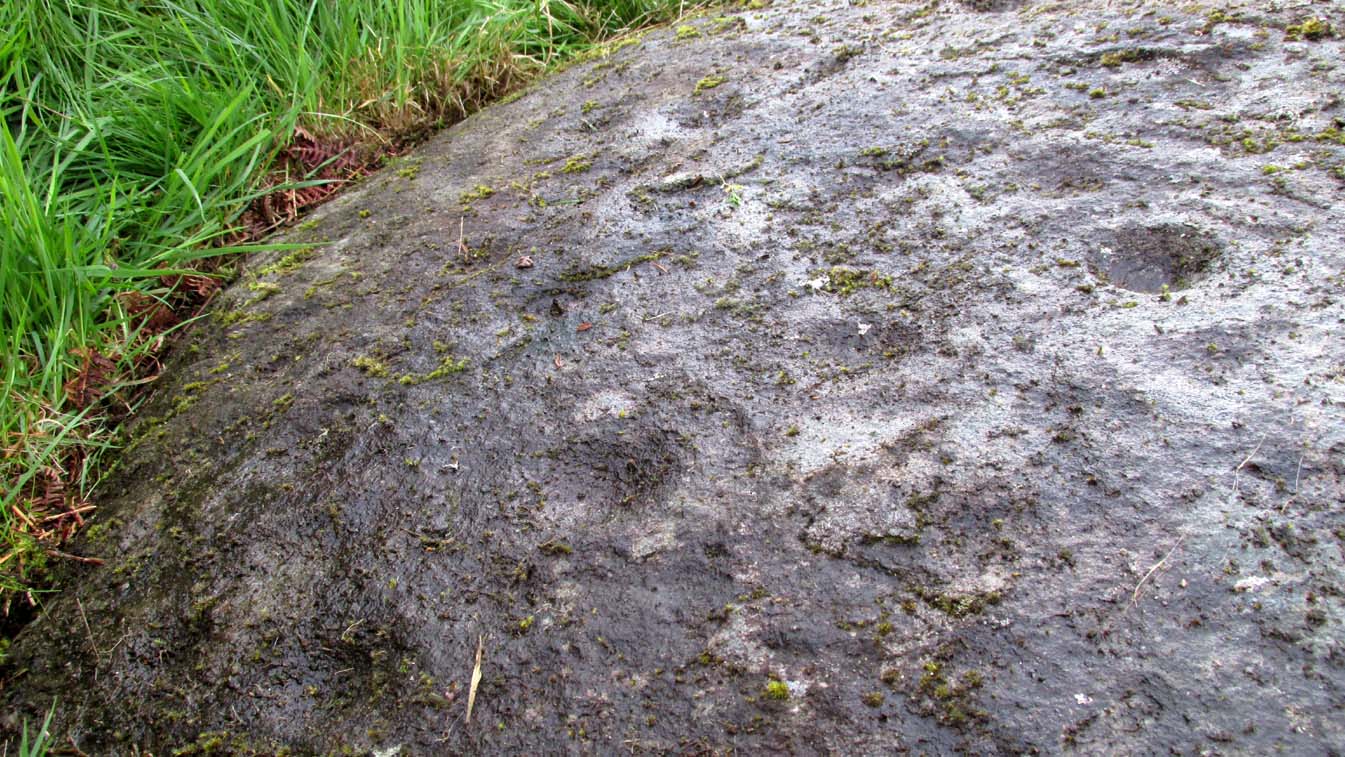
The Peace Stone in 1899
This seemingly isolated petroglyph, known about by local people in the middle of the 19th century and earlier, was said to have been “held in great reverence.” It was first mentioned in literary accounts in 1866, when the oral traditions about it were more important than any archaeocentricism. But things change with the times: local people were kicked off their lands, old stories and knowledge of sites were lost, and the ‘discipline’ of archaeology was beginning to look at these curious carved rocks with puzzled minds.
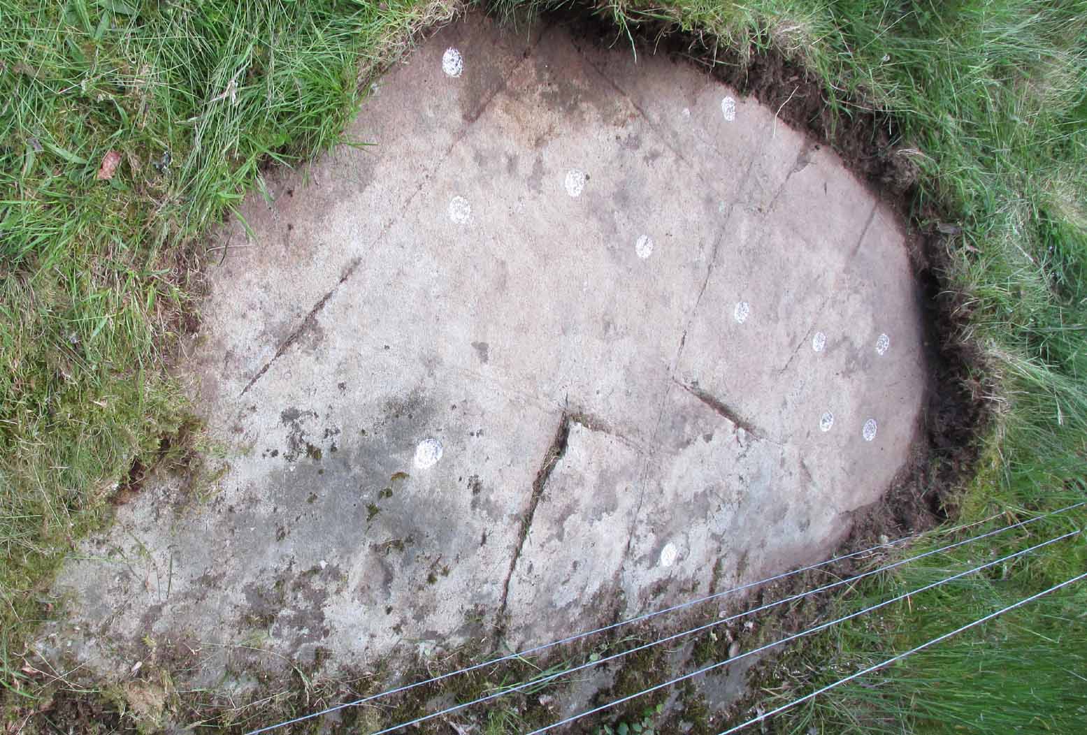
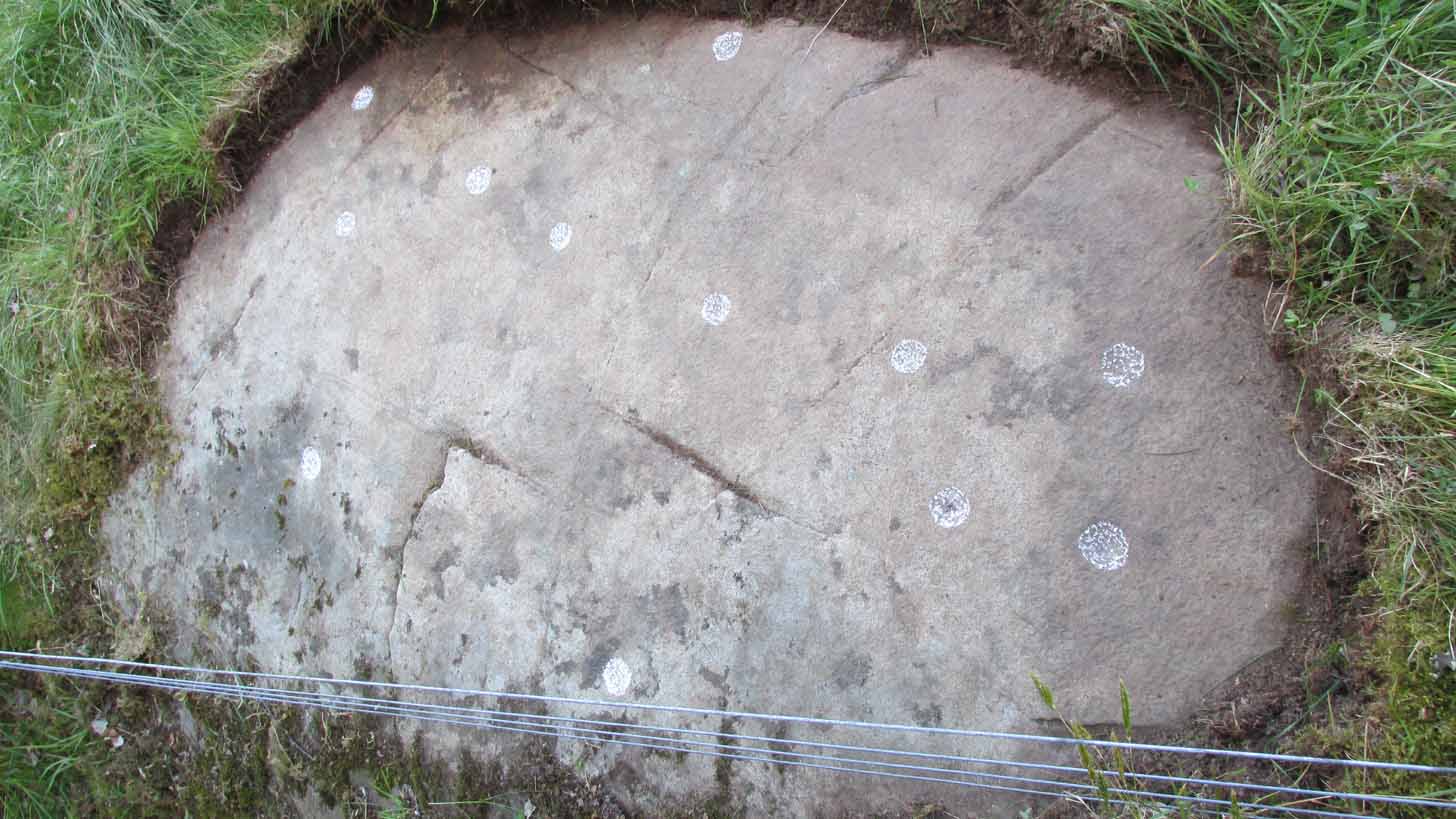
The Peace Stone was described at some length and with considerable accuracy in Mr A.F. Hutchison’s (1893) gazetteer on the ancient stones of Stirlingshire. It was one of the regions only known petroglyphs at that time and thankfully he gave us a good account of it, saying:
“On the west ride of the Lake of Menteith, about half a mile south from the farm-house of Malling, this stone is to be found, lying at the boundary of the arable land. The ground at the place rises into a slight eminence, on the top of which the stone lay till some seven or eight years ago, when a labourer took it into his head that a stone on which so much labour had evidently been spent must have been intended to cover something valuable. He proceeded to excavate the earth at the side with the intention of getting at the buried treasure, with the result that the stone slipped down into the hole which he had made, where it now lies. It is quite possible, however, that an interment, if no treasure, might be found beside it on further research. The stone is roughly circular on the surface, measuring about 4 feet in diameter. It is entirely covered with cup and ring marks—22 cups in all—varying in size from an inch to two inches in diameter. The cups and rings are very symmetrically formed. Nearly in the centre is a fine one surrounded by four circular grooves. Others have incomplete triple and quadruple circles, with radial duct dividing them. There are other curious curves that sometimes interlace, and near the lower side of the stone are five or six cups with straight channels running out from them over the edge. This is an extremely interesting stone. It is unique in our neighbourhood, so far as I know, in showing these symmetrical carvings. They are now, however, much weather-worn.”
Ron Morris’ sketch & photoClose-up of faded cups
When Alison Young (1938) came to write about the carving, she echoed Hutchison’s thought that the stone might originally have covered a tomb—but we simply don’t know and it should be treated as guesswork, as there are no known prehistoric tombs anywhere hereby.
Years passed before the next archaeological visit – by which time the stone had been uprooted and moved, apparently “ploughed up by the Forestry Commission”, and when Ron Morris (1981) last sought it out found that “the stone was un-traceable”. On a previous visit, before being moved, he found it to be,
“a cup-and-three-rings, 3 cups surrounded by two rings…and 6 cup-and-one-ring. One of these and 2 cups form part of the design of the cup-and-three-rings. There were also at least 7 other cups, and a number of grooves, some forming lines from a central cup, or a cup-mark, downhill. Greatest diameter visible in 1977 30cm (12in) and depth of carving 3cm (1 in)… Many of the carvings are so weathered as to be visible only when wet in early morning or late evening.”
And when we visited the site a few days ago, the stunning sunlight that had followed us all day, sadly faded and disallowed us better photographs of the site. Huge apologies…. But it’s worth visiting when the daylight’s good, perhaps when you’re exploring the huge number of brilliant petroglyphs at Ballochraggan and Nether Glenny on the hillside 1½ miles immediately north of this “outlier”, as Brouwer & van Veen (2009) called it.
Folklore
In a landscape bedevilled with stunning petroglyphs, traditions and folklore of them is all but gone; but the story of the Peace Stone was thankfully captured in words by Mr Dun (1866), who told us:
There is a curious prophecy connected with a stone situated near the ruins of the chapel of Arnchly, and which is worth recording. From time immemorial this stone went under the name of the Peace Stone, and it was held in great reverence by the natives. One Pharic McPharic, a noted Gaelic prophet, foretold that, in the course of time, this stone would be buried underground by two brothers, who, for their indiscretion, were to die childless. By-and-by the stone would rise to the surface, and by the time it was fairly above ground, a battle was to be fought on “Auchveity,” that is, “Betty’s Field.” The battle was to be long and fierce, until “Gramoch-Cam” of Glenny, that is, “Graham of the one eye,” would sweep from the “Bay-wood” with his clan and decide the contest. After the battle, a large raven was to alight on the stone and drink the blood of the fallen. So much for the prophecy then; now for the fulfilment. About fifty years ago, two brothers (tenants of the farm of Arnchly), finding that the stone interfered with their agricultural labours, made a large trench, and had it put several feet below the surface. Very singular, indeed, both these men, although married, died without leaving any issue. With the labouring of the field for a number of years, the stone has actually made its appearance above ground, and there is at present living a descendant of the Grahams of Glenny who is blind of one eye, and the ravens are daily hovering over the devoted field. Tremble ye natives! and rivals of the “Hero Grahams,” keep an eye on Gramoch-Cam!
The name of Betty’s Field came from an earlier piece of folklore: where a prince out hunting a stag was caught in one of the deep bogs hereby, only to be rescued by a local lass. In return for her help, she was given a large piece of land which was to bear her name.
References:
Armit, Ian, “The Peace Stone (Port of Menteith parish),” in Discovery & Excavation Scotland, 1998.
Dun, P., Summer at the Lake of Monteith, James Hedderwick: Glasgow 1866.
Hutchison, A.F., “The Standing Stones and other Rude Monuments of Stirling District,” in Transactions Stirling Natural History & Antiquarian Society, volume 15, 1893.
Hutchison, A.F., The Lake of Menteith: Its Islands and Vicinity with Historical Accounts of the Priory of Inchmahome and the Earldom of Menteith, Stirling 1899.
Maitland, Mrs, “Cup Marked Stones”, in The Scottish Country Woman, 1935.
Mallery, Garrick, “Pictographs of the North American Indians,” in Bureau of Ethnology of the Smithsonian Institution, volume 4, 1886.
Morris, Ronald W.B., The Prehistoric Rock Art of Southern Scotland, BAR: Oxford 1981.
van Hoek, Maarten, “Menteith (Port of Menteith parish) Rock Art Sites,” in Discovery Excavation Scotland, 1989.
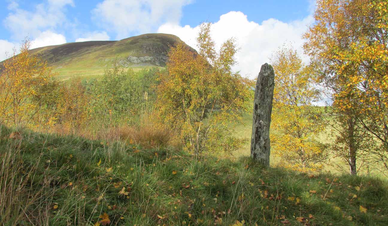
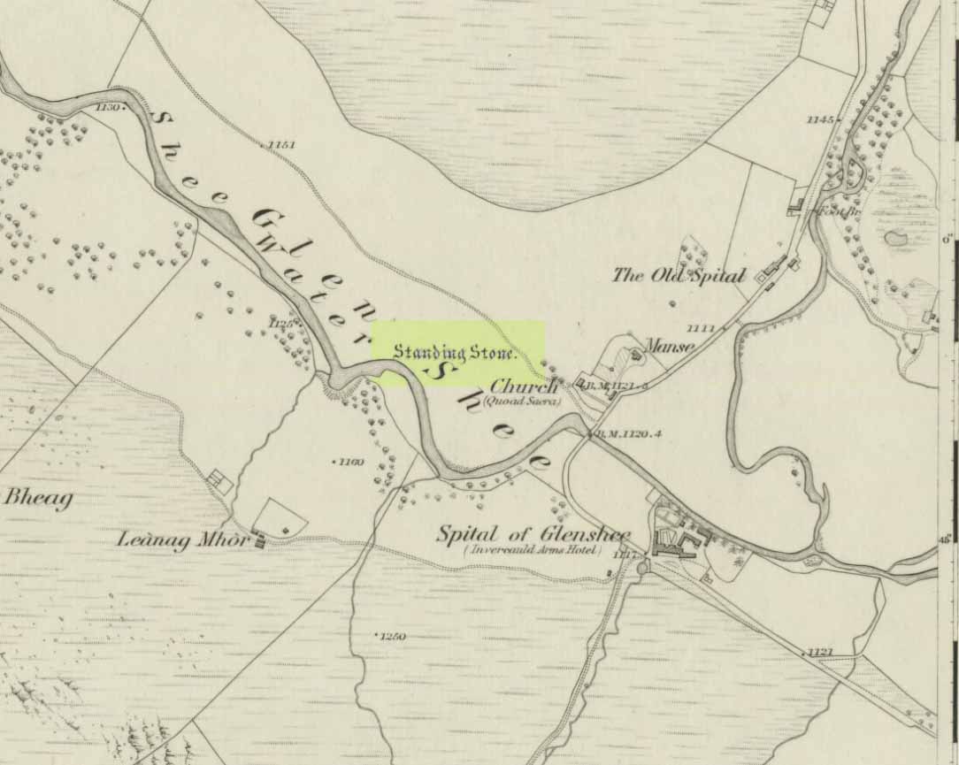
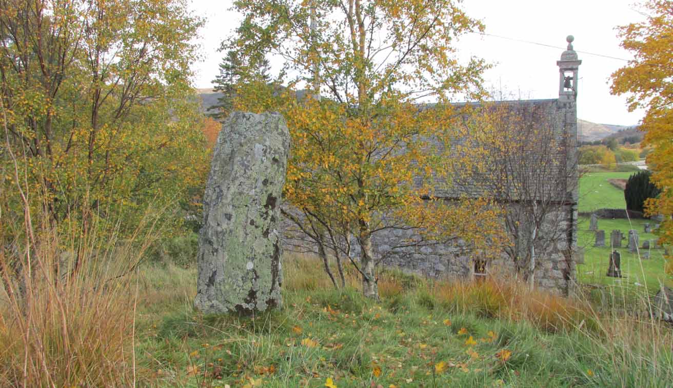
Take to A93 road, north, between Blairgowrie and Braemar, keeping your eyes peeled many miles on, to turn left along the minor road as you approach the tiny Spittal of Glenshee hamlet. Just as you go over the ancient bridge, park up on your left, below the church. Walk round the back of the church and you’ll see a large tree-covered mound. Walk onto its top.
Archaeology & History
Stone marked on 1862 map
This quiet, almost hidden, six-foot tall standing stone on what initially seems to be a large fairy mound or tumulus at the back of the rude church, has been occluded from general view (in my opinion, deliberately) by the construction of the more debased christian edifice right in front of it. But it detracts not from its gentle majesty once you reach its ancient body, atop of the old hill.
The stone is one in a cluster of prehistoric sites in and around this Glen of the Fairy Folk (as its name tells), where the rivers Shee and Beag converge. If the church didn’t obstruct the view, some of the other sites would have been visible from here.
Folklore
The old stone, looking east
Folklore tells that when the christians came into the Glen to build a church—initially a half-mile or so to the east—the little people were much annoyed at the actions of the incomers, as it intruded on one of their sacred rings of stone close by. By night they came out, and every stone that had been laid by the christians in the day was removed. Each day the insensitive christians came and built their church without asking, and each night the little people removed it. Eventually an agreement was made, and the fairies let them build the church next to this standing stone. So goes the tale….
A veritable cluster of stories about Fingal, Ossian, Dermid and Grianne scatter this area, with many of them relating to ancient sites, but I’ve not found one directly relating to this stone.
References:
Miller, T.D., Tales of a Highland Parish, Munro Press: Perth 1929.