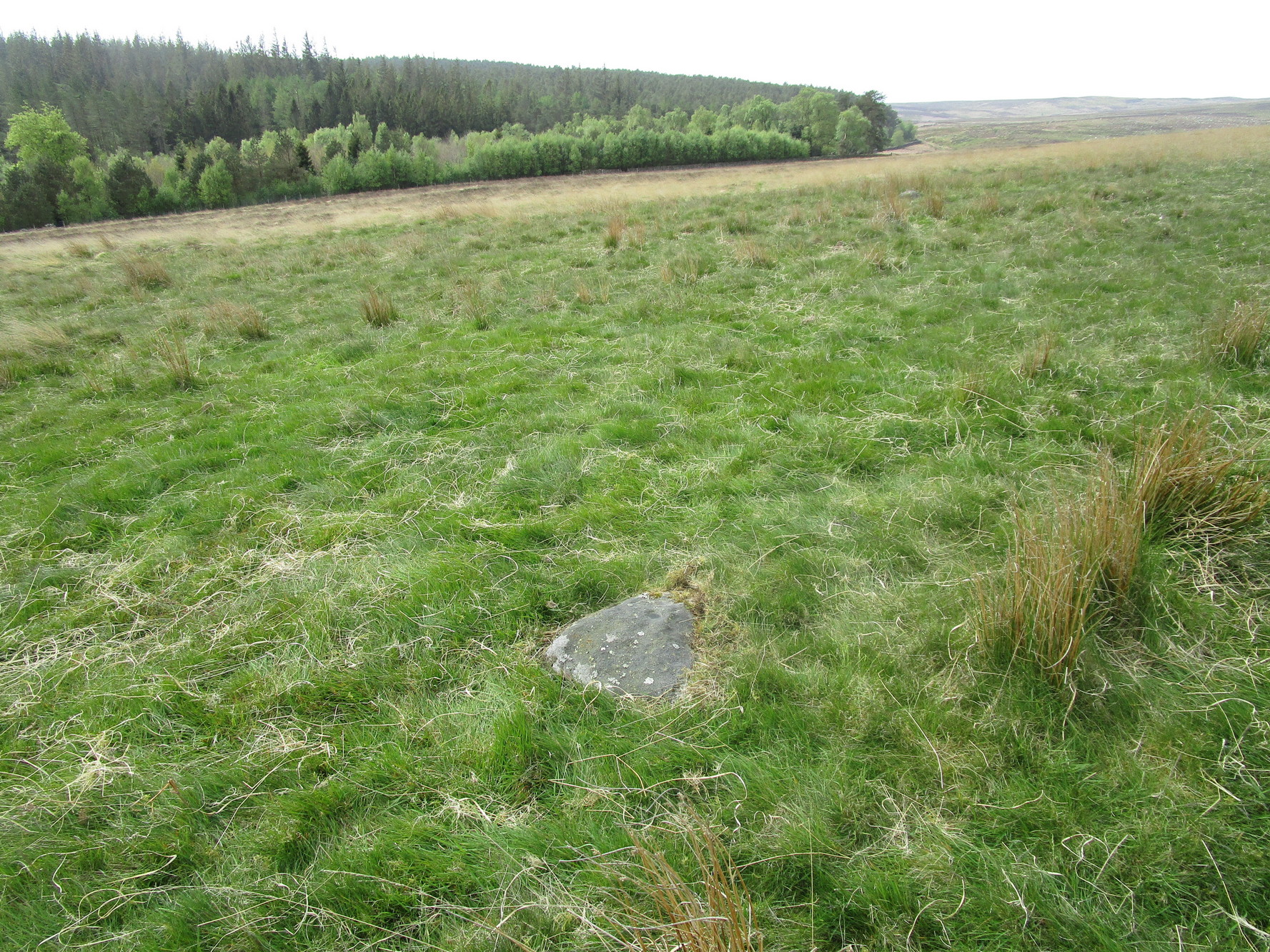
It’s probably easiest to start from the Green Plain settlement, from here crossing the Sun Bank Gill stream and walking east through the scattered heather and grasslands for 450 yards to the right-angled edge of the woodland. Keep walking eastwards alongside the woods for about another 250 yards, then walk into the grasslands north for about 140 yards or so. Zigzag about – you’re damn close!
Archaeology & History
Only for the purists amongst you. This is a simple small triangular stone, with a single notable cup-mark near the middle. It would seem to be in isolation as we could find no others in the immediate vicinity. An early marker no doubt.
Acknowledgements: With thanks to Helen Summerton, who helped with location on this fine day.
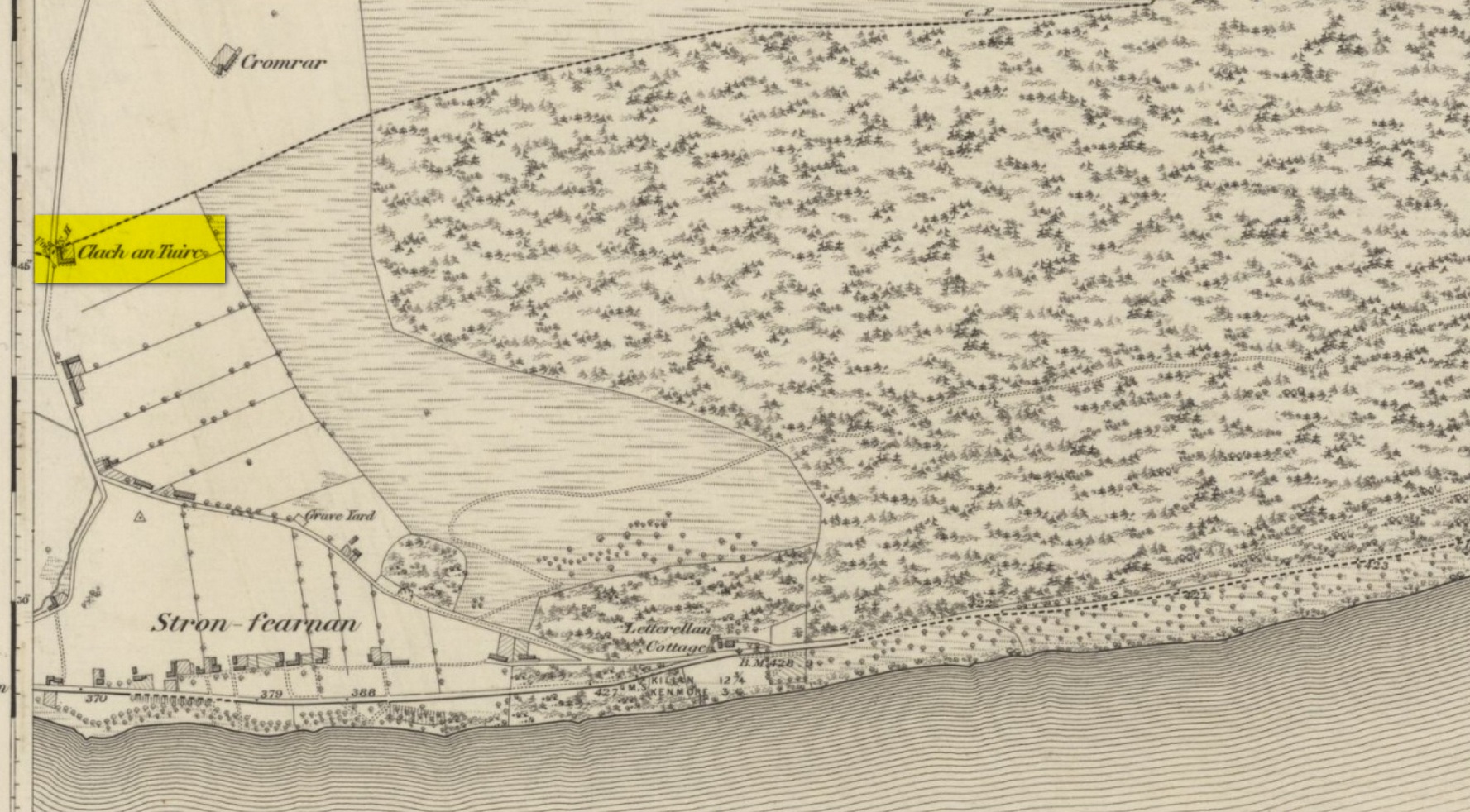
Pretty easy to find unless the vegetation takes over! From Fearnan take the road to Fortingall. Just as you’re going out of Fearnan, in the walling by the very last house on the right-hand side of the road is this large earthfast boulder. Y’ can’t miss it!
Archaeology & History
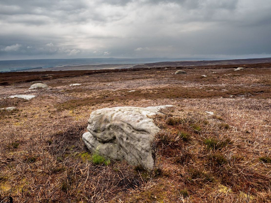
I first visited the Clach an Tuirc – or the Boar’s Stone – in 1981 when I stayed at Fearnan for a few weeks and, after clambering on top, looked down on the several simple cupmarks. Forty years later, I returned with a camera!
First highlighted on the 1862 OS-map, Fred Coles (1910) made a brief note of the petroglyph in one of his megalithic surveys, but only noticed a single cup, saying:
“Near Cromraor, close to the cottage at Clash na Tuirc, stands the large boulder bearing that name, the Boar Stone. Its highest point is about six feet above the road, and bears one very distinct cup-mark.”
But there are several cup-markings on top of the stone, just as William Gillies (1938) described.
Folklore
Not far from here tradition tells of a legendary figure who is known today only as the Lady of Lawers (whom tradition asserts to have been a member of the Stewart family, from Appin, Argyll – they of the daemonic Red Book of Appin). She made various prophecies, one of which said “that when Clach an Tuirc, the Boar’s Stone at Fearnan, would topple over, a strange heir would come to Balloch.” Though as the stone still aint toppled, we’re still waiting… (let’s just hope this doesn’t augur more of those selfish tories into our mountains who bring with them their mantras of “gerrof mah land”)
References:
Coles, Fred, “Report on Stone Circles Surveyed in Perthshire (Aberfeldy District),” in Proceedings Society Antiquaries, Scotland, volume 44, 1910.
Gillies, William A., In Famed Breadalbane, Munro Press: Perth 1938.
MacMillan, Hugh, ‘Notice of Two Boulders having Rain-Filled Cavities on the Shores of Loch Tay, Formerly Associated with the Cure of Disease,’ in PSAS 18, 1884. ???
Yellowlees, Walter, Cupmarked Stones in Strathtay, Scotland Magazine: Edinburgh 2004.
Acknowledgements: Huge thanks for use of the 1st edition OS-map in this site profile, Reproduced with the kind permission of the National Library of Scotland.
This one really takes some finding. Take the high moorland road running between Lofthouse and Healey villages, and at the very top by the cattle-grid, park up. Walk across the road and walk east. A mile or so on you’ll pass the Shooting Lodge house: keep walking for nearly another mile where another track goes left. Walk down here about ½-mile and you’ll see a crag down the the slope on your right. From here, walk uphill to your left; over the wall, and keep going about 500 yards until the moorland levels out. Hereby is a small outcrop of rocks. Look around!
Archaeology & History
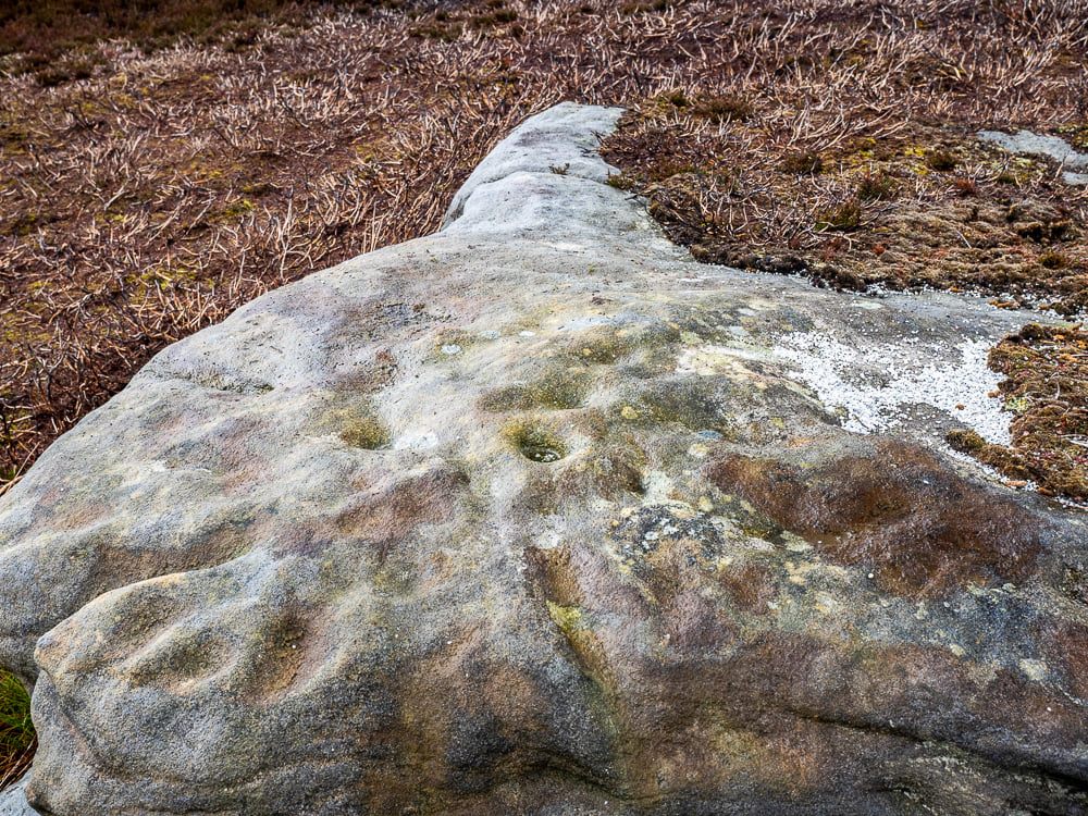
Recently rediscovered by young antiquarian Mackenzie Erichs in May 2021, this flat rock—roughly 5 feet by 3 feet— is one of many amidst the heather which, when fully grown, is gonna be hard to see. This is one of the many petroglyphs possessed with both natural and artificial elements roughly of the same number here.
Upon the mainly southern-side of the stone is a cluster of cup-marks with several on the edges of the rock, most of which are probably natural, or naturally affected. The main cluster of cups—about eight in all—have differing levels of erosion, suggesting differing periods of execution. The most obvious cup is the deep one near the middle of the stone; a group of 3-4 very eroded ones are closer to the edge; and 2-3 three others of varying shallow depths can be seen. One of the cups at the edge of the rock may also have been partially worked.
Healing Well (destroyed): OS Grid Reference – SP 166 350
Archaeology & History
This is one of several iron-bearing wells (chalybeates) that used exist in and around the village. Mentioned briefly in Alfred Soden’s (1875) history of the parish, he told that,
“years ago, there were several chalybeate springs here, very strongly impregnated. One of these was at the lower end of Westmacott’s Lane: of this spring there is now no visible trace, it having been built over.”
Although Mr Soden said nothing about the healing properties of this well, due to the mineral composition of chalybeates they always tend to be good fortifiers or pick-me-ups, being good for the blood. And in this case, as the waters were “very strongly impregnated” they would have possessed some considerable local renown.
References:
Soden, Alfred J., The History of Blockley, J.W. Parbury: Coventry 1875.
Healing Well (destroyed): OS Grid Reference – SP 163 347
Archaeology & History
It would seem that there’s no longer any trace of a healing well of some renown that once existed on the south side of Blockley village. It is mentioned briefly in Alfred Soden’s (1875) history of the parish, where he wrote:
“At the back of what is called “Bath Orchard,” now belonging to Mr. John Herbert, there was a well called “Blind Well;” the medicinal properties of the water being considered to be remedial in cases of weak eyesight. The writer has been informed that persons would come from a considerable distance to fetch water from this well for the purpose of bathing the eyes.”
References:
Soden, Alfred J., The History of Blockley, J.W. Parbury: Coventry 1875.
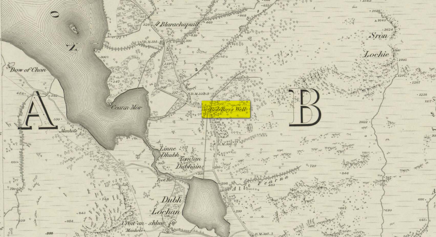
This long-forgotten site was found just by the old roadside several miles northwest of Aberfoyle, up the B829 Loch Chon road. Shown on the first Ordnance Survey map of the area in 1866, subsequent visits showed no remains of it and we must assume it had fallen back to Earth. When we visited the place recently, although there were no remains of any water trough, the spot where the well was shown on the map was very boggy with a small trickle of water running out of the slope. There is the possibility that, if the soaked soil just above the trickling water was excavated a few feet into the ground, that the original spring might be retrievable.
Obviously, its name tells of the tradition that this was a place where Rob Roy was known to drink. A number of places in this area bear his name. Surely this is a site that is worthy of bringing back to life, so to speak, and place it on the Scottish heritage map, where it belongs?
Acknowledgements: Huge thanks for use of the 1st edition OS-map in this site profile, Reproduced with the kind permission of the National Library of Scotland.
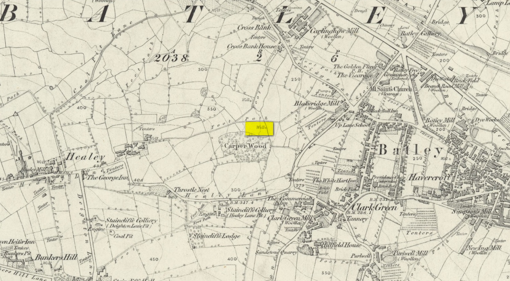
In days of olde, before folk had taps to turn to get water, they’d have to go to the nearby wells and streams. Many of these places were never written about, even to the point where no place-names were recorded, simply because the writers and surveyors either didn’t talk to the right people, or the right people didn’t talk to the surveyors! In many cases, the latter is all too true. Such is the case with this long forgotten healing well, whose memory is only preserved through the pen of a local man who, in the 19th century, was fortunate to have been able to write…
We know that old wells were mainly the province of women in most cultures through history; and Isaac Binns (1882) intimated this in his brief notes about the Wood Well. There’s nowt much to tell to be honest, but its location and lore need to be preserved.
Lamenting the loss of trees, Mr Binns told of the Wood Well’s proximity to Carper Wood: shown on the first OS-maps, but long since destroyed by the ignorance of modernity. In his day, the water from here was fresh “clear water.” This alone was good, but something extra in the water gave it that added healing ingredient. It was used medicinally,
“good yet, the old women say, for sore eyes.”
But not long after he wrote those very words, the Wood Well was destroyed…
References:
Binns, Isaac, From Village to Town: Random Reminiscences of Batley, F.H. Purchas: Batley 1882.
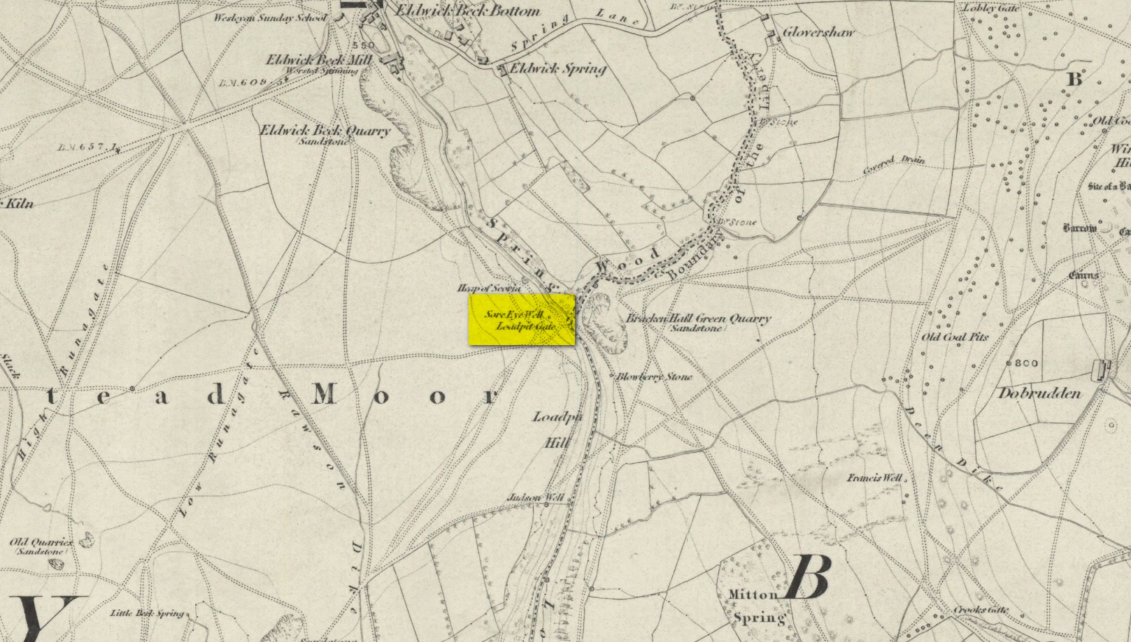
Healing Well (destroyed): OS Grid Reference – SE 1286 4007
Also Known as:
Loadpit Well
Archaeology & History
Sore Eye Well on 1852 map
Descriptions of this site are few and far between, despite it having a meaningful name. First recorded on the 1852 OS-map, in the folklore of our ancestors this was a well that local people frequented to wash their face and it was said that the waters would take away the ills of those suffering poor eyesight or other ocular problems. Rags were left hanging over an old rowan tree as offerings to the spirit of the water, in return for curing the afflicted eyes.
When I first came looking for this as a boy, I was frustrated to encounter the water authority’s metal cover ruining the site completely, leaving nothing of the old well as it once was. Around the metal-cover was evidence of a small rock enclave that would have defined the spring as it emerged from the earth—although it was barely noticeable. The remnants of a small path just to the right of the main footpath that reaches up the hillside is apparent, leading to the well. Below it were the remains of a large, water-worn flat rock, with other stones set to its sides, where the water used to flow and be collected, but today everything’s dried up and there’s little evidence of it ever being here.
References:
Shepherd, V., Historic Wells in and Around Bradford, Heart of Albion: Wymeswold 1994.
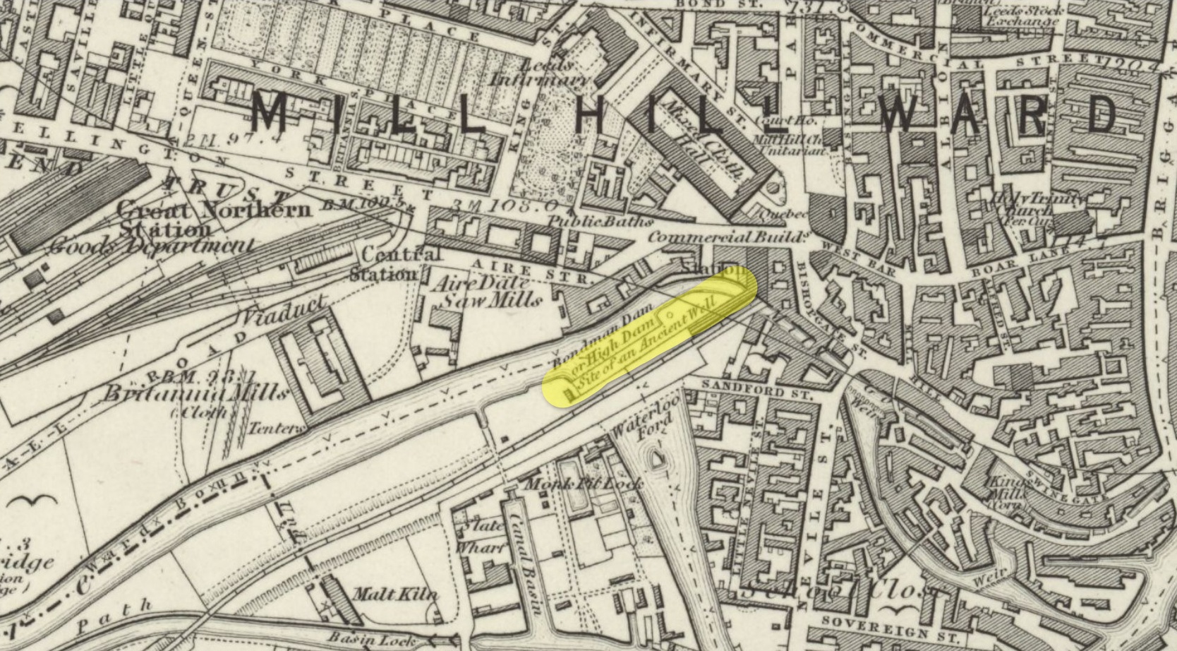
Healing Well (destroyed): OS Grid Reference – SE 2986 3331
Archaeology & History
First mentioned in the 1715 magnum opus of Ralph Thoresby, this old healing well has long since fallen victim to the careless Industrialists. In his day, the well was there for all to use, saying:
“Eye-bright Well on a declining Ground, near the Monk-Pits, discovers its Virtues in the Name, being, long-ago, esteemed a Sovereign Remedy against Sore-Eyes.”
This note was subsequently copied in in Hope’s (1893) classic survey, with no additional comment. In all probability, the name of the well derived from the presence of the herb Eyebright (Euphrasia officinalis) which, as is well known, is the best herb for ailments of the eye. The water from the well, in combination with the herb that grew around it, no doubt increased its ocular healing abilities.
By the middle of the 19th century, the rise of Leeds city brought an end to its ancient flow and its location was eventually forgotten. In Bonser’s (1979) survey of Leeds’ wells, he told how,
“the position of this well can be accurately determined: it was situated on sloping ground between Wellington Street and Aire Street, as clearly indicated on the 1847 (1850) OS 5ft to 1 mile (map).”
Location of Eyebright Well on 1852 map
However, in the much earlier survey of Leeds, Edward Parsons (1834) told us that this well was a hundred yards to the south, “near the line of the new road to the iron bridge across the Aire at the Monk Pits.” And although it isn’t named, it should be noted that immediately across the River Aire, where Parsons stated, the 1852 OS-maps showed the “Site of an Ancient Well.” This is very likely to be where it was. Parson’s also echoed the local lore of the time, telling us that the Well was “a sovereign remedy for soreness of the eyes.”
References:
Bonser, K.J., “Spas, Wells and Springs of Leeds,” in The Thoresby Miscellany – volume 16, Leeds 1979.
Hope, Robert Charles, Legendary Lore of the Holy Wells of England, Elliott Stock: London 1893.
Parsons, Edward, The Civil, Ecclesiastical, Literary, Commercial and Miscellaneous History of Leeds, Halifax, Huddersfield, Bradford, Wakefield, Dewsbury, Otley – volume 1, Frederick Hobson: Leeds 1834.
The earliest OS-map of this area shows this well a hundred yards or so northwest of an old church and just a few yards east of the stream that is now in woodland; but unlike today, when the early survey was done there were no trees, enabling a clear view of the waters. When Myles Ronan (1927) wrote of the place, he told that it was still visible. The site was added to the Grogan & Kilfeather (1997) county inventory where they suggested it’s probable relationship with the legendary St Brigid. This seems highly probable. Does anyone know if the Well is still there?
References:
Grogan, Eion & Kilfeather, Annaba, Archaeological Inventory of County Wicklow, Stationery Office: Dublin 1997.
Ronan, Myles V., “The Ancient Churches of the Deanery of Arklow”, in Journal Royal Society Antiquaries, Ireland, December 1927.