In days of olde, close to the modern M8 on the edge of the modern industrial estate north of Eastfield, was once an old solitary tomb whose home had laid here, undisturbed, until the coming of the Industrialists. Thought to have been a Bronze Age tumulus, it was destroyed sometime around 1768 according to the regional historian David Ure (1793) who told that,
“A small mound at Hamilton Farm was levelled about 25 years ago. In it was found a “stone coffin” containing human bones.”
The Royal Commission (1978) lads think this may have been the same prehistoric tomb that was reported found on the nearby estate of Farme and destroyed that same year. We have no idea what became of the remains and no trace is left of the site.
References:
Royal Commission on Ancient & Historical Monuments of Scotland. Lanarkshire: An Inventory of the Prehistoric and Roman Monuments, HMSO: Edinburgh 1978.
Ure, David, The History of Rutherglen and East Kilbride, Glasgow 1793.
Landscape of Giants Knowe (photo by Marion Woolley)
Amidst the colourful and nurturing landscape close to the gigantic Dunruchan standing stones and just along the road from the solitary Craigneich stone, in the field across the road above Straid farmhouse could once be seen a fascinating-sounding prehistoric site that has sadly been destroyed. Some of the remains of this old monument can be found in the field-clearance of stones just over the fence, above the top of the field (many fields round here have scatterings of large stone clearings at the field edges), but we have no detailed accounts of the site. It was mentioned in early notes by the Ordnance Survey to have been,
“A large circular heap of small stone and gravel entirely removed in 1831. An urn filled with ashes and several stone coffins were found under it.”
The local historian John Shearer (1883) later told us that,
“A small mound of earth on the farm of Strayd, called Crock-nafion or the Giant’s Knowe, or the Fingalian’s Knowe, was cleared away several years ago. An urn containing burnt bones was discovered.”
Any additional information about this site and its folklore, would be greatly appreciated.
Folklore
To the west along Glen Artney whence our view takes us from here, old legend told that the valley was once the abode of a great giant who lived in a cave in one of the mountains thereby. In mythic lore, giants were the creation deities of hills, mountains and other geological forms, whose narratives were overturned and demonized by the incoming christian cult many centuries ago. It is likely that this once great tomb was deemed as the burial-place of our local giant – which would make this prehistoric site neolithic in age. But — logical though it is — this idea is pure speculation…
References:
Hunter, John, Chronicles of Strathearn, David Philips: Crieff 1896.
Shearer, John, Antiquities of Strathearn, David Philips: Crieff, 1883.
On the level ground a half-mile south of the large Fairy Knowe prehistoric tomb, Bridge of Allan had a site of its own up until being destroyed sometime in the 19th century. Nothing much is known about the tomb – or “cist containing a skeleton”, as the Royal Commission (1963) lads called it – apart from the notes given in J.E. Alexander’s (1868) essay on the Fairy Knowe, where he told:
“It is right, however, to mention, that a few years ago, in digging the foundations of the house of Annfield, Bridge of Allan, at nine feet from the surface, there was found in the sand, and apparently undisturbed, a fine cist, containing the skeleton of a young female; and under the right arm was a small clay urn, corroborating the opinion of Professor Innes, that in many cases the so-called urn was simply a domestic jar to contain food for the deceased.”
A Mr R. Swift from Bridge of Allan told that the cist was located at the newly-named Lentran, along Kenilworth Road. Does anyone know anything more about it?
Royal Commission on the Ancient & Historical Monuments Scotland, Stirlingshire: An Inventory of the Ancient Monuments – volume 1, HMSO: Edinburgh 1963.
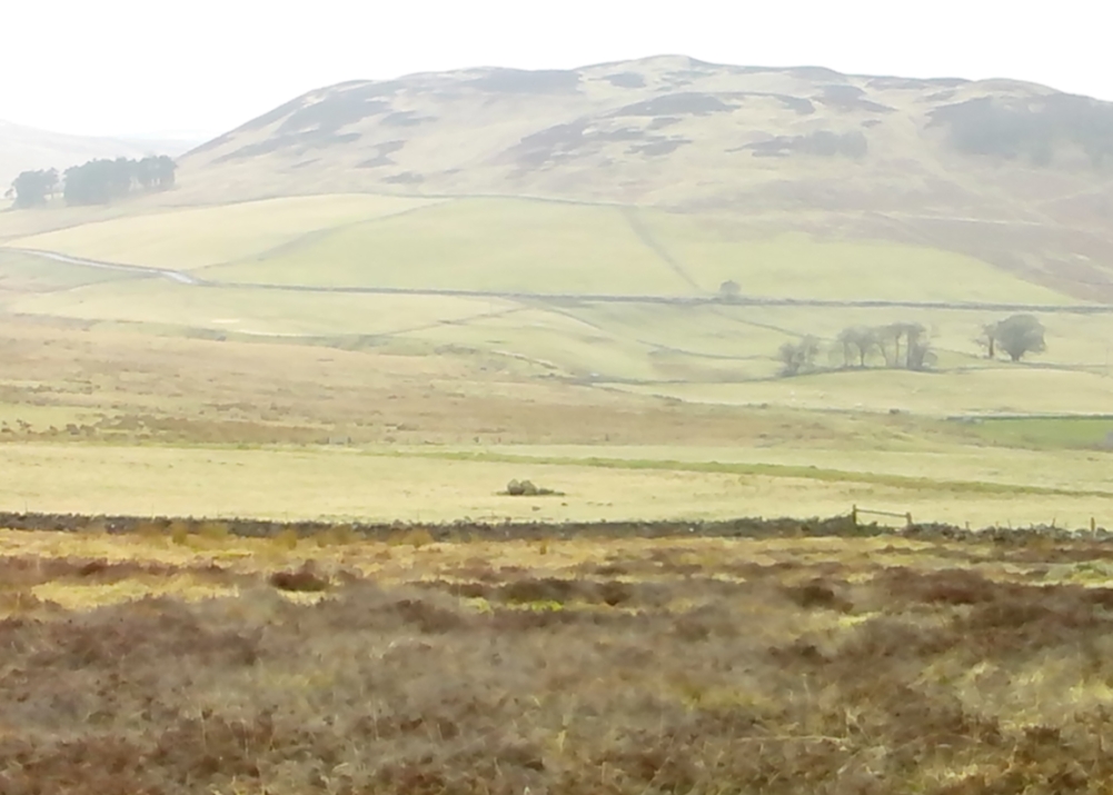
Probably the easiest (direction wise) is if you’re coming from Dick Hudson’s public house on the southern road surrounding Rombalds Moor. From the pub, head left (east) along Otley Road (passing Weecher reservoir) for 1.9 miles (3.1km) until you reach Reva reservoir where a track leads you to the waters. A small parking spot is on the left-side of the road. From here, go through the gate and along the footpath across the field for nearly 300 yards to the next gate; go through here and walk to your right for about 60 yards where uyou’ll reach a small straight dyke (keep your eyes peeled!) running NW (to your left): walk along here for nearly 200 yards until it hits another shallow dyke bearing right; follow this dead straight for 35 yards after which it changes direction, but you need to keep walking straight on forward for another 60 yards or so. Look around!
Archaeology & History
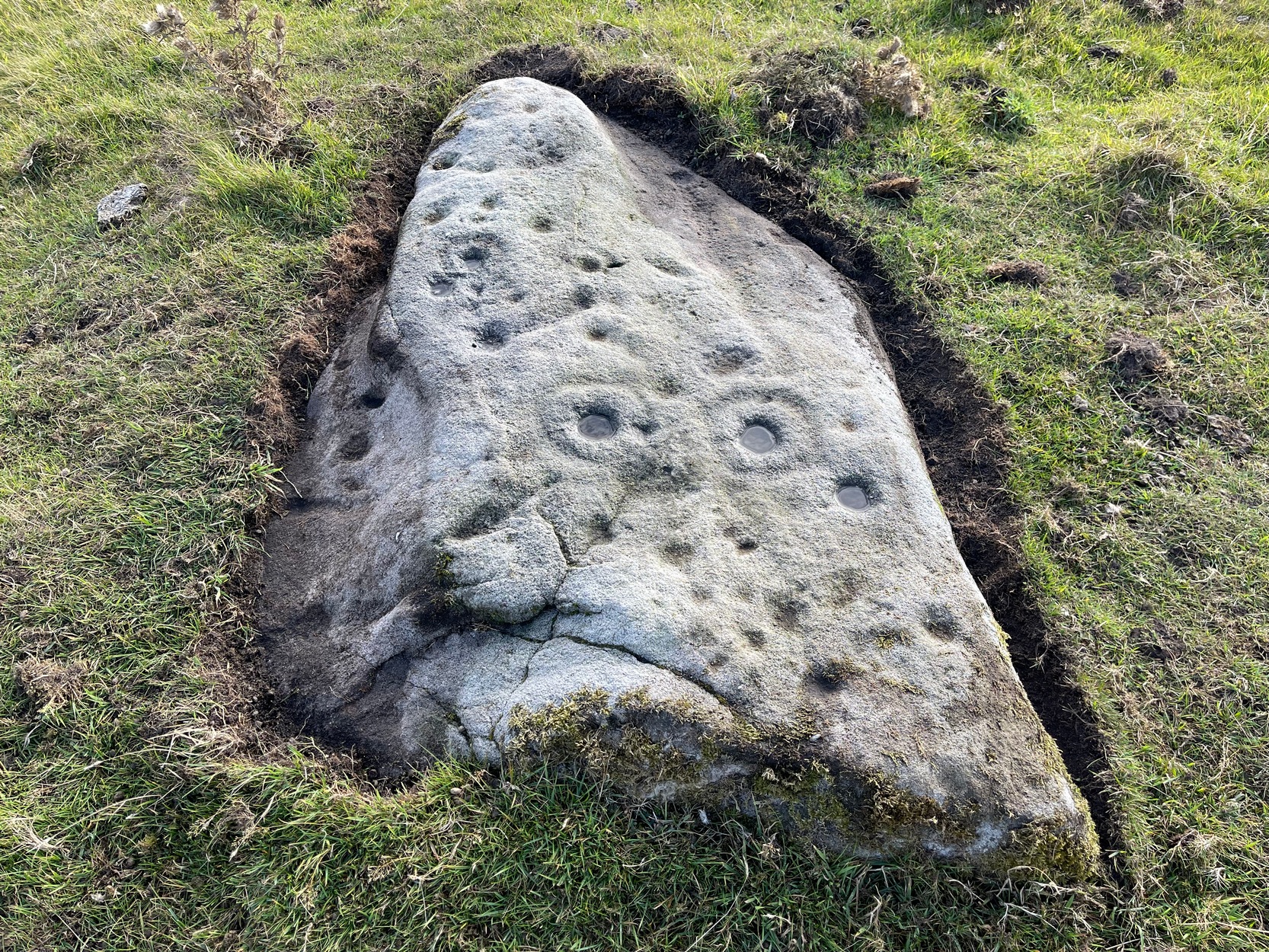
First photo of the carving
This carving is one in a cluster of previously unrecorded petroglyphs, uncovered in the summer of 2011 during a Northern Antiquarian bimble on the northern edge of Rombald’s Moor. The carvings were found as a bi-product of uncovering a previously undiscovered cairn circle, close to the Twelve Apostles stone circle. In assessing and exploring the newly-found circle, it was noticed that a small opening in the near horizon highlighted a rise in the landscape barely a mile away. This ‘opening’ in the land was not visible if you walked 25 yards either side of the cairn circle – but was very notable at the circle itself.
“We need to have a look at that site,” I said. “It’s position looks to have been relevant to this circle.” (or words to that effect) And a couple of weeks later we met up and walked to the place in question.
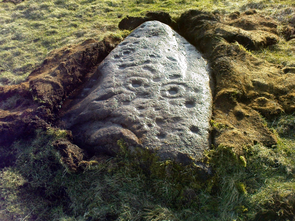
Fraggle Rock carving, looking westFraggle Rock carving, looking south
Within five minutes we came across a couple of previously unrecorded cup-marked stones, of simple design, right in line with the cairn circle. As we walked around this spot, then headed back in the direction of the circle, a cluster of small stones were noticed on the slope. One had what looked like a single cup-marking near its edge, but the rest of the rock was completely covered in vegetation. Paul Hornby and Michala Potts had, by now, already found several other previously unrecorded cup-marked stones close by; but as I carefully rolled back the vegetation at the edge of this particular rock, cups-and-rings and carved lines seemed to be covering most of its surface. It was a good one!
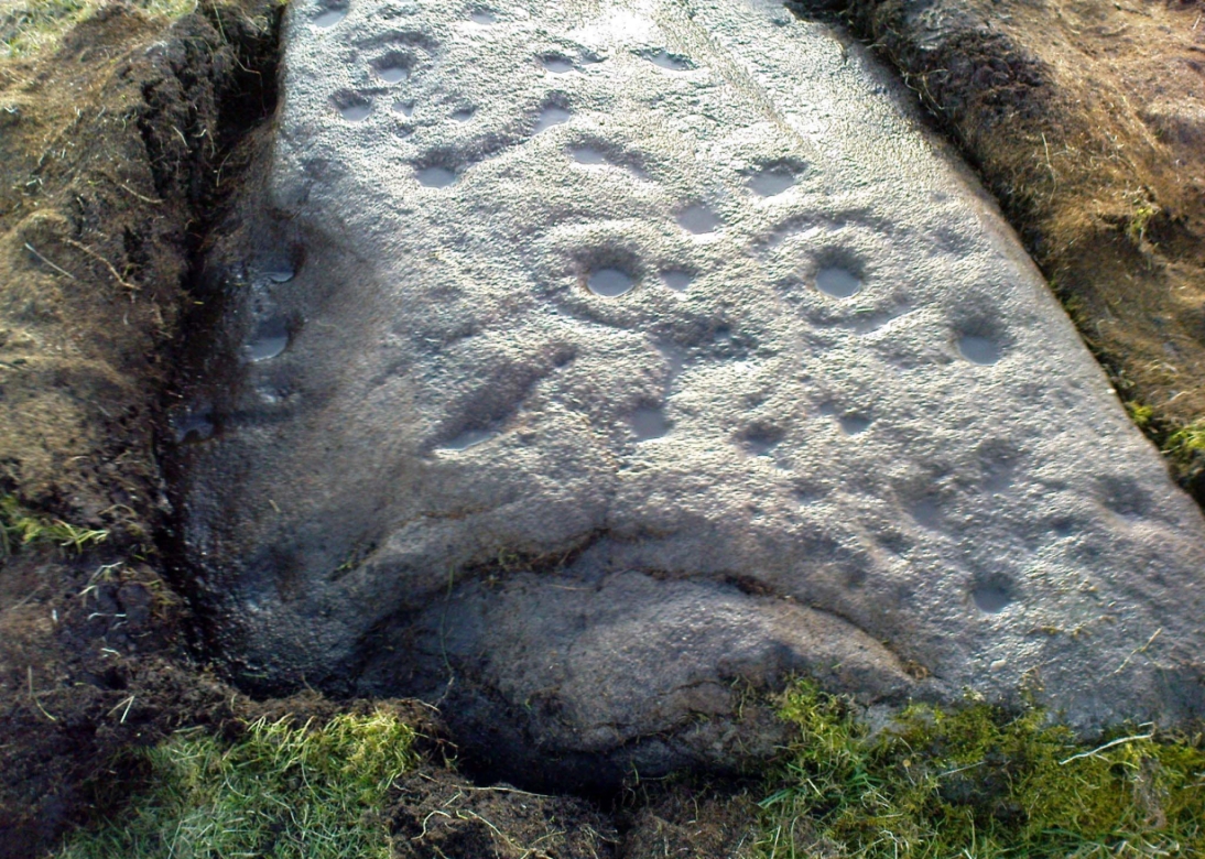
Face on the Fraggle Rock
We called it the Fraggle Rock after noticing that when you look at the stone from one end, the two main cup-and-rings are likes two large eyes carved above a large natural down-turning ‘mouth’ feature, similar to some of the creatures’ faces on the muppets or the similar kid’s TV show, Fraggle Rock! (sad aren’t we!?) The photo here shows you what we mean.
The primary design consists of at least 3 cup-and-rings, 2 partial cup-and-rings, 28 cups and several carved lines along which some cup-markings are linked to others. The most notable of the carved lines is the longest (barely visible in the photos), running from a single cup-mark at the southernmost rounded end of the stone, almost straight and parallel with a natural ridge or dip along the rock, until it meets the largest of the cup-and-rings (one of the eyes on the Fraggle’s face!). Don’t ask me why, but for some reason this long faint line seemed the most perplexing element of the carving.
Eastern edge with low cupsCup-marks on rock edge
Most of the design is carved on the upper face of the stone, but a small part of the rock dips into the ground on its eastern side and a small group of cups and a single carved line, in a very good state of preservation, are etched right at the edge of the stone. Unusual. Another faint cup-and-ring is less than 100 yards west; and a fascinating cup-and-lines stone, with at least four long carved ridges running like hair from the top of the stone into the Earth, is a short distance to the north. A number of others are in this and adjacent fields.
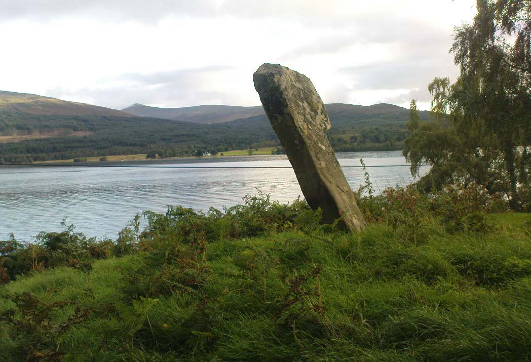
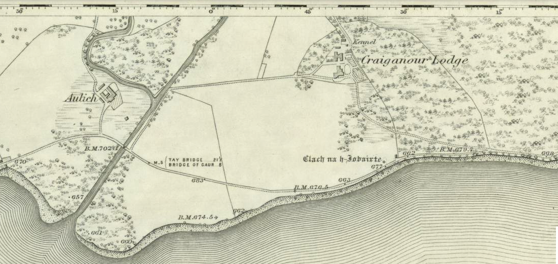
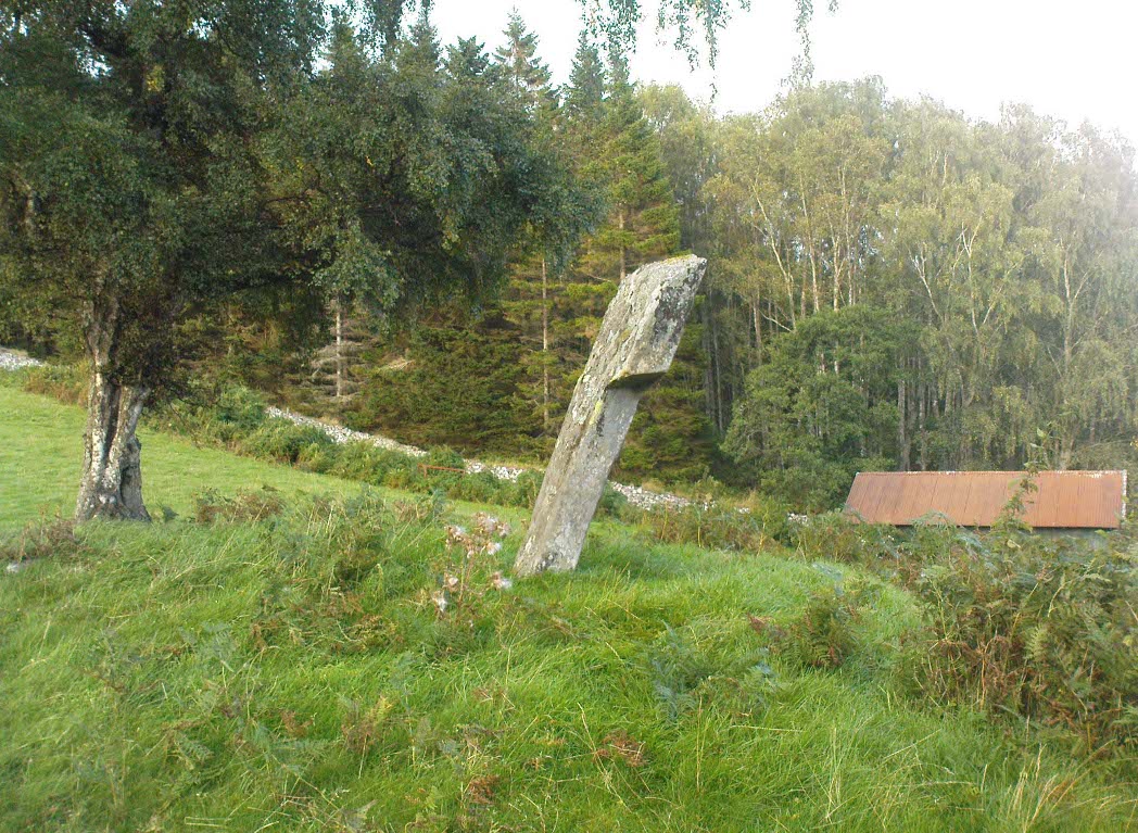
From the gorgeous village of Kinloch Rannoch, take the road along the north side of Loch Rannoch for about 2½ miles. As you go along the road, for a good mile or so it is wooded. Where the woods stop and the first field appears on your right, stop! You’ll see the standing stone perched erotically at an angle above you.
Archaeology & History
Clach na h-Iobairte, looking east
A fascinating site in a quite beautiful setting, typical of the Highlands. This stone of many names is a curiously-shaped monolith: like an erect stone penis at the edge of the field when seen from the roadside, calling out to christians and pagans alike, to be castigated or rubbed—whatever the religious preference of the surveyor! Leaning over at a slight angle, the stone is still nearly six feet tall and lives upon a large and equally prehistoric stone cairn about 30 feet across. This cairn, it is said, has been added to by locals when the field was cleared of stone and piled on top of the old tomb. No excavations have been done here, nor at the large ‘hut circle’ in the same field about 50 yards away.
Folklore
So far I have only found a short narrative of this stone in the pages of T.R. Barnett’s (1944) loving account of the Perthshire hills, where he tells that, close by the stone at Aulich, was once
“a famous smith, said to be in league with the devil, and he made the finest claymores in Rannoch.”
References:
Barnett, T. Ratcliffe, The Road to Rannoch and the Summer Isles, John Grant: Edinburgh 1944.
Cunningham, A.D., A History of Rannoch, privately printed 2004.
Tumulus (destroyed): OS Grid Reference – TM 0628 2022
Archaeology & History
Alresford Hill urn
In a region well known for the finding of early British remains (Belloc 1905), another prehistoric burial mound was destroyed in the Essex landscape simply due to ignorance and neglect. Thankfully once more we have local antiquarians and an astute schoolgirl for discovering and preserving a record of this site, otherwise we’d have no record of the place at all! Described in M.R. Hull’s (1946) article on some of the Bronze Age relics of the area, he told how a well-preserved urn in the edge of the tumulus,
“was found in June 1942 by a schoolgirl, Miss Anne Pilkington, on the top of the hill overlooking Alresford Creek and the Colne Estuary, about 70 yards northwest of Bench Mark 74.8 and 560 yards slightly west of south from Alresford church, west of the road to the creek and south of the lane running west along the north side of the field. This is the northern limit of a huge gravel-pit. She noticed the vessel standing upright in the side of the pit and recovered it. Nothing else was noticed…
“Afterwards the diary of our late Fellow, Mr P.G. Laver came into my hands and I find under the date 8th July, 1922, that he noticed, when motoring past the site, ‘a definite tumulus, but much ploughed down, now barely 18ins above the field level. It is close to the road through the field, the centre being roughly 20 yards S of the road and about 200 yards from the road to the ford.’ The sketch-plan leaves no doubt on the identity of the site.”
Annoyingly though, Mr Hull didn’t think it worthwhile to reproduce this alleged sketch-map. He did however give us a good description of the urn and its position in the ground, saying,
“The vessel is stated to have been about 5ft below the surface when found, but I am not certain whether the top-soil had been removed or not. The clay is fine, burnt light red, but black within, and the whole body is covered with horizontal lines impressed in exactly the same way as (those on the Flag Inn urn), but much less clearly. The base is slightly hollowed beneath and is not far from having a foot-ring.”
Folklore
Mr Hull (1946) also made an interesting comment on the views of local people about the site where Anne had found this urn, reminding me of what Highland and hill folk would have put down to faerie-lore, though no such memory was noted. He told:
“On enquiry I learnt that no one had observed a mound at the spot, but that it had been observed that exactly there the corn, when the field was cultivated, grew taller and greener in a large round patch”!
References:
Belloc, Hilaire, The Old Road, Archibald Constable: London 1905.
Hull, M.R., “Five Bronze Age Beakers from North-East Essex,” in Antiquaries Journal, volume 26, Jan-April 1946.
Tumulus (destroyed): OS Grid Reference – TM 117 178
Archaeology & History
Bronze Age beaker from the Flag Inn tumulus
Roughly halfway between Thorrington and St. Osyth, a few hundred yards east of the Flag Creek on the grassy wasteland south of the historic Flag Inn, could once be found a fine tumulus, of whose past we sadly know so little. Nothing now remains of the old burial mound apart from a carved urn that once lived therein and was recovered from the site before its final demise. According to M.R. Hull (1946) the well-preserved Bronze Age beaker found here—which he said “stood out as different” from others in this area—
“was found in 1930 on the 50ft contour-line about 200 yards south-southeast of the Flag Inn, in a gravel pit, in St. Osyth parish. The position is a mile and a quarter north-northwest of St. Osyth church. On this occasion it was not possible to examine the site, which could only be established with moderate accuracy some time after the discovery…
“The clay is fine, of light red colour, ornamented with three bands of trellis pattern, each bounded by three horizontal lines, and a band of four such lines at the base, all executed with an instrument making a short line of square impressions, probably the end of a comb used in weaving.”
References:
Hull, M.R., “Five Bronze Age Beakers from North-East Essex,” in Antiquaries Journal, volume 26, Jan-April 1946.
Tumulus (destroyed): OS Grid Reference – TL 8228 2704
Archaeology & History
Aerial image showing ghostly circular outline
This is one of many lost prehistoric burial sites destroyed in Essex in recent centuries and whose only remains now, as seen here to the right, are the ghostly outlines left in the Earth when looking down from above. We are very fortunate indeed in even having a record of this place—this time thanks to an astute fellow antiquarian hearing of some old remains alleged to have been in an old burial mound, south of Greenstead Green.
It’s short story was described in M.R. Hull’s (1946) essay on a series of Bronze Age beakers in Essex that were found in association with once-proud tumuli, living amidst a landscape held as sacred by our peasant ancestors. Although we have no good description of the tumulus, Mr Hull said that this well-preserved clay beaker,
Perces Bronze Age beaker
“was found in 1930 on the 200ft contour-line 366 yards due south of Piercys in the parish of Halstead…that is 2¼ miles south-southeast of Halstead Church. I visited the site immediately after the discovery with our late Fellow, Mr P.G. Laver, and the finder assured us that no other remains were found. He had dug a small pit into the natural gravel, and in doing so came upon this vessel at a depth of 7ft from the surface. When we arrived the burial pit had been destroyed, and, although the depth of the vessel from the surface suggests that a tumulus existed, we were unable to see any remains of it. We found a calcined flint…in the excavation. The vessel…(of) clay is fine, containing a very small quantity of quartz-like grit; the colour is a warm red-brown, and the body is decorated all over with finger-nail impressions.”
References:
Hull, M.R., “Five Bronze Age Beakers from North-East Essex,” in Antiquaries Journal, volume 26, Jan-April 1946.
From the railways station, walk to the dual carriageway (crossing the road) and walk on the A907 road to your left; cross the next road & walk round the corner, crossing the next road by the zebra crossing. OK, walk to your right, bearing immediately left down Devon Road, then just 20 yards on take the footpath up the side of the house on your left, and keep walking until you go into the trees. Then keep your eyes peeled for the fairy mound with a rock on top of it!
Archaeology & History
Overgrown cairn, looking NE
This is a large rounded, almost archetypal tumulus, sitting just a couple of minutes walk out of Alloa town centre, sandwiched between streets in the remaining copse of trees running east-west along Hawk Hill. Although the mound is of considerable size—with a large curious block of stone plonked on top—it hasn’t always been like that and has evidently been rebuilt sometime in the 20th century, for when the Royal Commission (1933) lads visited the site in July 1927, they reported only a bare trace of the old tomb, saying:
“The site of the cairn at Hawk Hill lies about 100 yds SSE of the lodge gate. The position is marked by a setting of young trees, but the ground has been cultivated and no definite outline of any structure can now be traced. A few loose stones of no great size, lying scattered about, are the only signs of a cairn.”
But the site is quite large, being more than 4 feet high and about 18 yards across, with a large flattened circular top. Nearby there was reported to have been another cairn, but this turned out to be little more than some recent debris.
Folklore
Local folklore tells that this monument is along a ley line that links it with the Hawk Hill Cross and destroyed stone circle east of here and the remains of a little-known standing on the outskirts of Alloa, to the west. I’ve not checked the precision of this alignment, but a quick scan of it looks pretty decent!
References:
Arabaolaza, Iraia, “Hawk Hill, Alloa,” in Discovery & Excavation in Scotland, New Series volume 10, 2009.
Royal Commission on the Ancient & Historical Monuments, Scotland, Inventory of Monuments and Constructions in the Counties of Fife, Kinross and Clackmannan, HMSO: Edinburgh 1933.
Royal Commission on the Ancient & Historical Monuments, Scotland, The Archaeological Sites and Monuments of Clackmannan District and Falkirk District, Society of Antiquaries of Scotland 1978.
Follow the directions to reach the Little Skirtful of Stones giant prehistoric cairn. Once here, look for the singular rocks out of the many thousands which make up the giant cairn, mainly from the middle to the northern-half of the cairn, and you’ll find them amidst the mass!
Archaeology & History
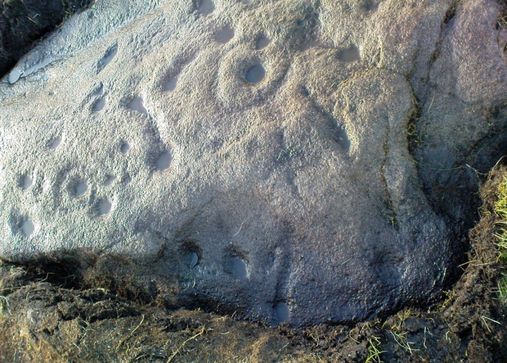
Cup-marking near the centre of the cairn
Despite the task sounding difficult, it’s not too hard locating the cup-marked rocks within this giant cairn. As I recall there should be five of them, though the Boughey & Vickerman (2003) survey only list four and I only have photos of four of them as well…so I reckon age is probably getting to me at last! There could very well be more of them amidst this massive tomb. But we certainly can’t rely on the Boughey & Vickerman (2003) survey for the carvings at this site as they give the wrong grid references for each of the cup-markings listed, with them all being a kilometre east from the site of the tomb itself! Awesome! God knows what their cartographer was on when he did the profiles for these carvings! (there are plenty of spliff-butts scattered over this moor…..) Not only that, but the position they cite of the relative cup-markings within the cairn are also wrong.
Another portable stoneCup-mark at outer edge
But for those of you who like to know the archaeological data, here’s what was said: Carving 391a is a “small rock towards SW edge of cairn, with single worn cup”; but this stone is actually closer to the northern section of the cairn. Carving 391b was told to be a “small dome-shaped rock at extreme S edge of cairn with single, small clear cup at top of dome.” This again is more on the northern section of the cairn, away from the centre. Carving 391c was described as a “small oval, rounded rock at N edge of cairn, with single, broad, shallow worn cup.” Whilst carving 391d which was told to be a “small rock at SSE edge of cairn, with single small worn cup.” However, we have to take into account that any errors about their position may simply be down to the fact that the small rocks have been moved.
Smoothed cupShowing different rock-type
As you’ll see in the photos here, one of them is actually near the very centre of the cairn, with the cup-marking etched into the edge of the small rock itself. I’m not quite sure if this is the additional fifth carving in the cairn, or whether it’s one of those wrongly ascribed as being in another position. It’s hard to tell, as the local Ilkley Archaeology team don’t publish their findings and information on-line as they should do and unless you’re in their little club they’re hard to get info out of. So this will have to do for the time being I’m afraid. Also note how one of the cup-marked stones is of a rock-type different to the local millstone grit.
Folklore
The creation myth of the Little Skirtful itself tells that the giant Rombald (who gives his name to the moor) was in trouble with his wife and when he stepped over to Almscliffe Crags from here, his giant wife – who is never named – dropped a small bundle of stones she was carrying in her apron. Harry Speight (1900) tells us of a variation of the tale,
“which tradition says was let fall by the aforementioned giant Rumbalds, while hastening to build a bridge over the Wharfe.”
Variations on this story have said it was the devil who made the site, but this is a denigrated christian variant on the earlier, and probably healthier, creation tale. Similar tales are told of the Great Skirtful of Stones, 500 yards south.
The cluster of portable small stones with single cup-marks on them relates to traditions found in other cultures in the world where, usually, women would carry such items in their aprons and deposit them at or on the tomb, in honour of the ancestor or spirit known to be resident at the sacred site. The folklore found at the Little Skirtful (and Great Skirtful too) of Rombald’s wife dropping the rocks here and forming the giant tomb, probably derive from variants of this same honorary practice.
References:
Bennett, Paul, The Old Stones of Elmet, Capall Bann: Chieveley 2001.
Boughey, Keith & Vickerman, E.A., Prehistoric Rock Art of the West Riding, WYAA 2003.
Cowling, Eric T., Rombald’s Way, William Walker: Otley 1946.