Follow Redmires road till you come to Wyming brook nature reserve and use the free parking facilities there. From the car park you need the signposted path to the right of the notice board, the first one not the one by the metal barrier; climb the rocky steps and follow the line of the dry stone wall to your left, and after around 50 metres you’ll pass through a wooden gate. You then continue following the wall as it heads downhill and the wall becomes broken. Here you should notice a path that goes through the broken wall off to your left: don’t take it but continue another 50 metres or so, then turn 90° to your right facing the moorland. The circle is around 50 metres into the heather.
Ash Cabin Flat Stone Circle – as of 26/5/09
Archaeology & History
A fairly well preserved late neolithic or early Bronze age embanked stone circle located in a sea of heather on Ash Cabin Flat on the Western outskirts of Sheffield and rediscovered in 1981 due to the moor being burnt back.
The site is oval in shape and around 9m x 7m diameter to the outer edge of the bank. The banking is well preserved and shows there was no entrance to the interior.
There are around a dozen stones within and on top of the bank but it’s uncertain whether they are circle stones or packing stones from the bank. English Heritage have recorded 5 of the stones, 2 still standing, as stones that once stood making up the circle.
If you visit any time soon (23/11/09) you’ll find the moor has been burnt back again giving an excellent view of the site, when the heather is in full flow it’s as high as the highest stones making not only finding the circle nigh on impossible to find but also defining the site very difficult.
Additional Notes:
Editor – 1.12.9. – Following a visit to this site in the company of Megadread recently, we found what appears to be a number of other cairns on the flat moorland plain around this seeming cairn-circle site. There also appeared to be distinct evidence of ancient walling. Further archaeological evaluations are required here.
References:
Burl, Aubrey, The Stone Circles of Britain, Ireland and Brittany, Yale University Press 2000.
From Ripponden, taken the steep road up to Barkisland, but at the crossroads just before the village, turn right (south) and keep going for a mile till you reach the reservoir. At the far-end of the reservoir, take the track down by its side and follow the footpath that bends round the edge of the grasslands. Go up onto this small moorland and, once you’re on the level, head towards where you’ll see a large pile of stones a coupla hundred yards away. That’s it!
Archaeology & History
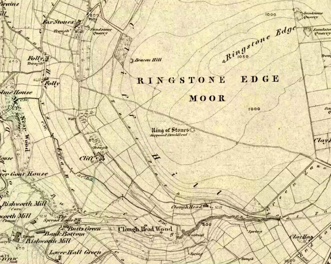
If we visit this site today, all we are left with is a scattered mass (or perhaps that should that be ‘mess’) of many hundreds of stones: the last remnants of what once would have been a proud circle of one form or another upon this small moorland plain. Its significance was such that the very moor on which its remains are scattered, was named after it: the Ringstone Edge Moor. But as with many sites from our megalithic period, this old place is but a shadow of its former self.
Gone are the upright monoliths which, tradition relates, once surrounded this low scattered circle of small loose stones (which would have made it look not unlike the wonderful stone circle of Temple Wood, Argyll). These standing stones were, so the folk record tells, removed near the end of the 18th century for use in some walling.
Described variously as a stone circle, ring cairn, cairn circle, an enclosure, and more, the site first seems to have been written about in 1775 by the great historian John Watson. When he was vicar of the local parish in Halifax (not far from here) this “ring of stones” as he called them, was “called the Wolf-fold.” Nearly one hundred years later, in F.A. Leyland’s superb commentary to Watson’s work, he wrote,
“The stones which constituted the circle at the time of their removal stood upwards of three feet…and the remain formed a striking object on the moor. The original number of stones of which the circle was formed is unknown, having long been in ruin and reduced in quantity before being finally removed. This was effected about twelve years since by the present tenant of the dam.” – that is, around 1859.
However, when Crabtree (1836) described the circle a decade or two earlier, he made no mention of such standing stones — although we must consider that Crabtree was very much like many modern academic archaeologists who tended to copy the works of others, much less than getting out in the field to see for himself.
At the beginning of the 20th century, the lore telling of the standing stones’ demise was repeated by local historian John Priestley (1903), when he said that: “all the large stones…were carted away about forty years ago” — that is, around 1863.
So it would seem that the very final destruction of the standing stones here, occurred sometime during the four year gap which Messrs. Leyland and Priestley describe.
More than fifty years later, Huddersfield historian James Petch (1924) came here to explore whatever remains he could find, and told:
“On top of a flat plateau on this moor, with an extensive view on all sides save on the north, where there is a gentle slope for some hundreds of yards up to the summit of the hill, there are distinct traces of a circular ring of small stones. Pygmie flints have been picked up within a yard or two, but the only other fact to be noted about this earthwork is that there is a tradition to the effect that much earth has been removed from this site. It is not altogether impossible that this is a scanty remnant of a round barrow.”
This latter remark of Mr Petch seems most probable. The excessive scatter of small stones typifies the remains of many of the Pennine giant cairns, from the Little Skirtful on Burley Moor and giant tombs of the Black Hills near Skipton, to the similar monuments of our Devil’s Apronful, Pendle, etc, etc.
Close to this cairn circle, wrote Sidney Jackson (1968), there used to be the remains of an Iron Age settlement, “marked by wall foundations (but) is now covered by the waters of Ringstone Reservoir.”
Folklore
There is very little folklore that I’ve found here. Watson (1775) throws the usual idea that the place was a site of druidical worship; but other than that we only have a local Ripponden writer’s account, which told that there was once the ghost of a white lady that was once said to walk along the path somewhere between here and the Beacon Hill tumulus, a short distance to the north.
Easy to find if you go at the right time of year — very troublesome to find if you go at the wrong time! Check the place out at the end of winter, beginning of Spring. It’s at the top end of Shipley Glen, just past where the road bends round and goes uphill. About 50 yards up, on the left side of the road walk into the grasslands for less than 100 yards. Look around!
Archaeology & History
An intriguing site this one. Intriguing as it wasn’t in the archaeological registers when I first came across it — and I’m really unsure whether it’s in there now. It probably has, as John Barnatt came here with some earth-mystery folk in 1982! But when I first visited this site in 1975 it seemed no one knew about it — and little has changed since then.
It is an enclosed ring of stones less than 30 feet across with an earth embankment separating it from what seems like a secondary ring on its outer edge, a foot or two away. This didn’t appear to surround the complete ring and may have been damaged. It had an appearance similar in size, shape and form to the Roms Law and Harden Moor sites, and thankfully in reasonable condition. I don’t think any excavation has yet been performed here though.
There are a number of other small standing stones on the outskirts of this ring that may have some relationship with the site, but we need excavation to prove one way or the other. Several very well-preserved cup-marked stones are close by.
Folklore
Intriguing to those of you who are fascinated by alignments between sites, or ‘leys’, as an impressive lines runs through this site. Starting at the little known Hirst Woods Circle and terminating at the giant Great Skirtful of Stones cairn, once passing over the now destroyed Weecher circle and the Brackenhall Green ring on its way.
References:
Bennett, Paul, The Old Stones of Elmet, Capall Bann: Chieveley 2001.
Get to the Twelve Apostles stone circle, then walk just 100 yards down the main footpath south, towards Bingley, and watch out for a small footpath immediately to your left. Walk on here and head for the rocky outcrop a half-mile ahead of you. Once past the outcrop, take the first footpath right and walk down for another 100 yards. Stop! – and walk into the heather. The circle’s about 50 yards away! You can of course come from the Menston side of the moor, following the same directions for the Great Skirtful of Stones, but keep walking on for another 200 yards, towards the rocky outcrop again, turning left down the path for 100 yards, before stopping and walking 50 yards into the heath again!
Archaeology & History
Roms Law circle
This is one of my favourite sites on these moors. I’m not 100% sure why – but there’s always been something a bit odd about the place. And I don’t quite know what I mean, exactly, when I say “odd.” There’s just something about it… But it’s probably just me. Though I assume that me sleeping rough here numerous times in the past might have summat to do with it, playing with the lizards, and of course…the sheep… AHEM!!! Soz about that – let’s just get back to what’s known about the place!
Grubstones is an intriguing place and, I recommend, recovers its original name of Roms or Rums Law. It was described as such in the earliest records and only seems to have acquired the title ‘Grubstones’ following the Ordnance Survey assessment in the 1850s. The name derives from two compound words, rum, ‘room, space, an open space, a clearing’; and hlaw, a ‘tumulus, or hill’ – literally meaning here the ‘clearing or place of the dead,’ or variations thereof. But an additional variant on the word law also needs consideration here, as it can also be used to mean a ‘moot or meeting place’; and considering that local folklore, aswell as local boundary records tell of this site being one of the gathering places, here is the distinct possibility of it possessing another meaning: literally, ‘a meeting place of the dead’, or variations on this theme.
The present title of Grubstones was a mistranslation of local dialect by the Ordnance Survey recorders, misconstruing the guttural speaking of Rum stones as ‘grub stones.’ If you wanna try it yourself, talk in old Yorkshire tone, then imagine some Oxford or London dood coming along and asking us the name of the ring of stones! It works – believe me….
The site has little visual appeal, almost always overgrown with heather, but its history is considerable for such a small and insignificant-looking site. First described in land records of 1273 CE, Roms Law was one of the sites listed in the local boundary perambulations records which was enacted each year on Rogation Day (movable feast day in Spring). However in 1733 there was a local boundary dispute which, despite the evidence of written history, proclaimed the Roms Law circle to be beyond the manor of Hawksworth, in which it had always resided. But the boundary was changed – and local people thenceforth made their way to the Great Skirtful of Stones on their annual ritual walk: a giant cairn several hundred yards east to which, archaeologically, there is some considerable relationship. For at the northern edge of the Roms Law circle is the denuded remnants of a prehistoric trackway in parts marked out with fallen standing stones and which leads to the very edge of the great cairn. This trackway or avenue, like that at Avebury (though not as big), consists of “male” and “female” stones and begins – as far as modern observations can tell – several hundred yards to the west, close to a peculiar morass of rocks and a seeming man-made embankment (which I can’t make head or tail of it!). From here it goes past Roms Law and continues east towards the Great Skirtful, until it veers slightly round the southern side of the huge old tomb, then keeps going eastwards again into the remnants of a prehistoric graveyard close by.
In my opinion, it is very likely that this trackway was an avenue along which our ancestors carried their dead. Equally probable, the Roms Law Circle was where the body of the deceased was rested, or a ritual of some form occurred, before taken on its way to wherever. It seems very probable that this avenue had a ceremonial aspect of some form attached to it. However, due to the lack of decent archaeological attention, this assertion is difficult to prove.
A previously unrecognised small single tomb is in evidence to the immediate southeast (5 yards) of the circle. There is also another previously unrecognised prehistoric trackway that runs up along the eastern side of the circle, roughly north-south, making its way here from Hawksworth Moor to the south. The old legend that Roms Law was a meeting place may relate to it being a site where the dead were rested, along with it being an important point along the old boundary line. Records tell us that the chant, “This is Rumbles Law” occurred here at the end of the perambulation – which, after the boundary change, was uttered at the Great Skirtful. This continued till at least 1901.
Northern section of the Ring
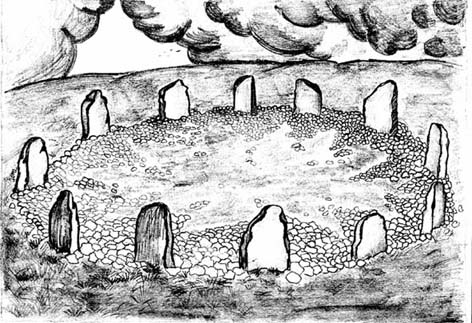
Modern archaeological analysis of the site is undecided as regards the actual nature of Roms Law. Ordnance Survey maps show it as an “enclosure” (which is vague); Faull & Moorhouse’s survey (1981) erroneously tell us it had no funerary nature, contrary to Eric Cowling’s (1946) report of finding bones and ashes from the small hole in near the centre of the ring, aswell as the 1880 drawing of the site in Collyer & Turner’s survey (above). And we find the single cairn on the south-eastern edge of the ring indicating burial rites of sorts definitely occurred here. Described variously by previous archaeologists as a stone circle, a ring cairn, cairn circle, an enclosure, aswell as “a rubble-fill wall of a circular house” (by some anonymous member of the West Yorkshire Archaeology Service, who didn’t respond to my queries about this curious assumption), the real nature of Roms Law leans more to a cairn circle site. A fine example of a cup-and-ring stone — the Comet Stone — was found very close to the circle, somewhere along the Grubstones Ridge more than a hundred years ago, and it may have had some relevance to Roms Law.
This denuded ring of stones is a place that has to be seen quite blatantly in a much wider context, with other outlying sites having considerable relationship to it. Simple as! (If you wanna know more about this, check out my short work, Roms Law, due out shortly!)
Describing the status and dimensions here, our great Yorkshire historian Arthur Raistrick (1929) told that:
“The larger stones still standing number about twenty, but the spaces between them are filled with stones of many intermediate sizes, so that one could with only considerable detail of size, etc, number the original peristalith.”
…Meaning that we’re unsure exactly how many stones stood in the ring when it was first built! Although a little wider, the Roms Law is similar in form to the newly discovered ‘Hazell Circle‘ not far from here. The site has changed little since Raistrick’s survey, though some halfwits nicked some of the stones on the southwestern edge of the site in the 1960s to build a stupid effing grouse-butt, from which to shoot the birds up here! (would the local council or local archaeologist have been consulted about such destruction by building the grouse-butt here? – anyone know?) Thankfully, this has all but disappeared and the moorland has taken it back to Earth.
There is still a lot more to be told of Roms Law and its relationship with a number of uncatalogued sites scattered hereby. Although it’s only a small scruffy-looking thing (a bit like misself!), its archaeology and mythic history is very rich indeed. “Watch This Space” – as they say!
Folklore
Alleged to be haunted, this site has been used by authentic ritual magickians in bygone years. It was described by Collyer & Turner (1885) “to have been a Council or Moot Assembly place” — and we find this confirmed to a great extent via the township perambulation records. Considerable evidence points to an early masonic group convening here in medieval times and we are certain from historical records that members of the legendary Grand Lodge of All England (said to be ordained in the tenth century by King Athelstan) met here, or at the adjacent Great Skirtful of Stones giant cairn 400 yards east.
The boundary perambulations which occurred here on Rogation Day relate to events just before or around Beltane, Mayday. Elizabeth Wright (1913) said of this date:
“These days are marked in the popular mind by the ancient and well-known custom of beating the parish bounds, whence arose the now obsolete name of Gang-days, and the name Rammalation-day, i.e., perambulation-day, for Rogation-Monday. The practice is also called Processioning and Possessioning… The reason why this perambulation of the parish boundaries takes place at Rogationtide seems to be that originally it was a purely religious observance, a procession of priest and people through the fields to pray for a fruitful Spring-time and harvest. In the course of time the secular object of familiarizing the growing generation with their parish landmarks gained the upper hand, but the date remained as testimony to the primary devotional character of the custom.”
And the calling of, “This is Rumbles Law” maintained this ancient custom when it used to be uttered here.
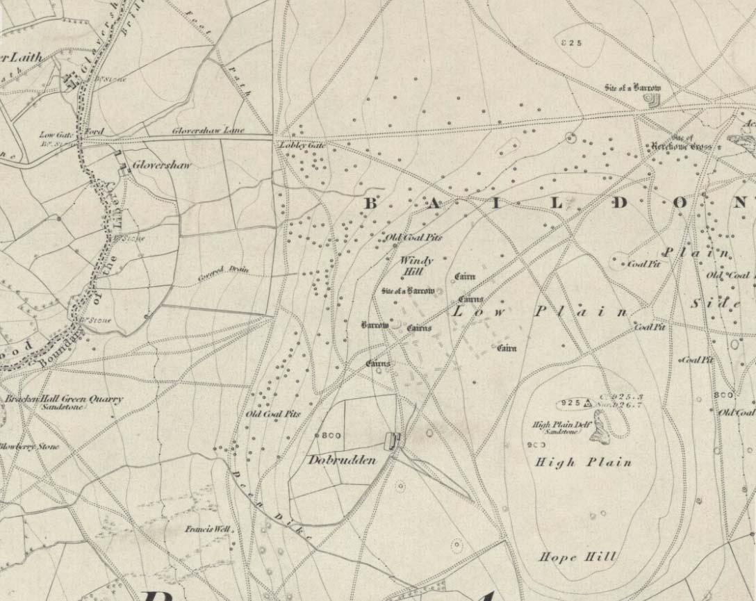
Stone Circle (destroyed): OS Grid Reference – SE 138 403
Windy Hill on 1852 map
Archaeology & History
The early northern antiquarian, J.N.M. Colls (1846), described visiting a ‘druidical circle’ of stones due east of the Dobrudden prehistoric graveyard, but it seems to have been completely destroyed soon after he wrote his essay, with the stones taken away for use in road-building. He told that here was,
“a double circle of stones, the outer ring numbering eighteen, with six stones making up the inner circle.”
…and his illustration shows just that! It’s possible that this inner ring may have covered a burial. Harry Speight — aka, ‘Johnnie Gray’ (1891) — is the only other writer I’ve found that refers to the megalithic remains up here, although he gave no additional details.
Windy Hill Circle (after Colls, 1846)
The site was to be found across the High Plain and Windy Hill, on the western edge of Baildon Hill, where there was once a greater profusion of seemingly neolithic and Bronze Age remains. Another possible early reference to the site is in Collyer & Turner’s Ilkley (1885), where they talk of a circle “on the highest part of the eastern moor,” fifty-six feet across with a similar appearance to the Pennythorn Hill circle, although they describe it as overlooking the hamlet of Sconce, which is hardly possible from the Windy Hill side of Baildon Moor.
The site looked across the horizon from south, through west to north and if used astronomically would have been used to observe sun and moonset times. Although we find a number of cup-and-ring stones in the vicinity, it really does seem that this site has bit the dust!
References:
Bennett, Paul, The Old Stones of Elmet, Capall Bann: Chieveley 2001.
Colls, J.N.M., ‘Letter upon some Early Remains Discovered in Yorkshire,’ in Archaeologia 31, 1846.
Collyer, Robert & Turner, J. Horsfall, Ilkley, Ancient and Modern, William Walker: Otley 1885.
Gray, Johnnie, Through Airedale, from Goole to Malham, Elliot Stock: London 1891.
There are several ways to get here, but I took the one from the road (B6265) walking up the track into Crookrise Woods. Unless you’ve got a decent OS-map with it marked on, this might take some finding to some folk as it’s tucked away on the northern edge of Crookrise Woods (which one Southerner bloke told us was private – though he was ‘allowed’ there!). It’s right on the rounded knoll at the top of the woods, beneath the prominent slopes which lead to the moor.
Archaeology & History
Our old mate and Yorkshire historian Arthur Raistrick seems to have been the first to describe this place in the Yorkshire Archaeological Register of 1964 – though the holy wells writer Edna Whelan told me she knew about the place many years back. Today hidden in woodland and mostly overgrown, Raistrick’s brief description of the place said:
“A small stone circle of six stones set symmetrically within a diameter of 26 feet. The stones vary in size from 21 to 58 inches. Surveyed 1963.”
The site has been badly affected by the erosion of time, forestry and god-knows what else. Scattered around are numerous small stones giving the impression that it may once have been a cairn-circle, more than a stone circle. Four of the six stones mentioned by Raistrick (1965) are visible, but none are impressive – and unless you’d read about the place first or found it in Mr Burl’s Stones Circles of Britain… (2000), you wouldn’t really give it the time of day.
Although sadly disappointing in its present status – completely surrounded by trees, with no view at all – it seems probable that it would have had some geomantic relationship with the hillfort-looking site of Rough Haw immediately west, and very probably the adjacent ritual site of Sharp Haw. It seems that the equinox sun would set between Rough Haw and the other small rounded hill above.
References:
Burl, Aubrey, The Stone Circles of Britain, Ireland and Brittany, Yale University Press 2000.
From Harden, go up Moor Edge High Side (terraced row) till you reach the top. Follow the path thru’ the woods on the left side of the stream till you bend back on yourself and go uphill till you reach the moor edge. Keep walking for about 500 yards and keep an eye out to your immediate left. The other route is from the Guide Inn pub: cross the road and go up the dirt-track on the moor-edge till you reach a crossing of the tracks where a footpath takes you straight onto the moor (south). Walk on here, heading to the highest point where the path eventually drops down the slope, SE. As you drop down, watch out for the birch tree, cos the circle’s to be found shortly after that, on your right, hidden in the heather!
Archaeology & History
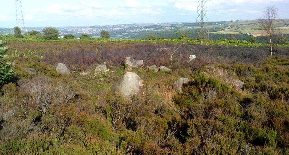
This aint a bad little site hidden away on the small remains of Harden Moor, but is more of a ‘ring cairn’ than an authentic stone circle (a designation given it by previous archaeologists). An early description of it was by Bradford historian Butler Wood (1905), who also mentioned there being the remains of around 20 small burials nearby. When the great Sidney Jackson (1956; 1959) and his team of devoted Bradford amateurs got round to excavating here, he found “four or five Bronze Age urns” associated with the circle. His measurements of the site found it to be 24 feet across, and although the stones are buried into the peat with none of them reaching higher than 3 feet tall, it’s a quietly impressive little monument this one. About 20 upright stones make up the main part of the ring.
I’ve visited the place often over the last year or so since a section of the heather has been burnt away on the southern edges of the circle. This has made visible a very distinct surrounding raised embankment of packing stones about a yard wide and nearly two-feet high, particularly on the southern and eastern sides of the circle, giving the site a notable similarity in appearance and structure to the Roms Law circle (or Grubstones Ring) on Ilkley Moor a few miles to the north.
There is also the possibility that this ring of stones was the site described by local historian William Keighley (1858) in his brief outline of the antiquities of the region, where he wrote:
“On Harden Moor, about two miles south of Keighley, we meet with an interesting plot of ground where was to be seen in the early days of many aged persons yet living, a cairn or ‘skirt of stones,’* which appears to have given name to the place, now designated Cat or Scat-stones. This was no doubt the grave of some noted but long-forgotten warrior.
* The Cairn was called Skirtstones by the country people in allusion to the custom of carrying a stone in the skirt to add to the Cairn.”
However, a site called the ‘Cat stones’ is to be found on the nearby hill about 500 yards southeast – and this mention of a cairn could be the same one which a Mr Peter Craik (1907) of Keighley mentioned in his brief survey of the said Catstones Ring at the turn of the 20th century. We just can’t be sure at the moment. There are still a number of lost sites, inaccuracies and questions relating to the prehistoric archaeology of Harden Moor (as the case of the megalithic Harden Moor Stone Row illustrates).
Section of the inner ring
The general lack of an accurate archaeological survey of this region is best exemplified by the archaeologist J.J. Keighley’s (1981) remark relating specifically to the Harden Moor Circle, when he erroneously told that, “there are now no remains of the stone circle on this site” — oh wot an indicator that he spent too much time with paperwork! For, as we can see, albeit hidden somewhat by an excessive growth of heather, the ring is in quite good condition.
It would be good to have a more up-to-date set of excavations and investigations here. In the event that much of the heather covering this small moorland is burnt back, more accurate evaluations could be forthcoming. But until then…..
Best approached by taking the same direction to the unexcavated Foster Clough ‘enclosure.’ From here, walk towards the walling about 100 yards to your east. Follow it along on the moorside for another 100 yards then follow the small sheep-path up the angle of the slope onto the moor itself. Once you’re at the top and on the level, it’s right ahead of you! If the heather’s deep though, you might as well give up before y’ start! (honest – I went there a while back for a night’s sleep & couldn’t find the damn thing!) But if you’ve made the effort getting here, wander 200 yards towards Crow Hill and keep yer eye out for the large heather-clad tumulus.
Archaeology & History
This site was rediscovered in October 1995, when I was bimbling about on the southern side of Crow Hill. It was one of those good periods, when the heather had been extensively burnt back, so enabling a better examination of the moors for any potential prehistoric remains. I unknowingly walked right into the middle of this small ring of stones with a fella called John Billingsley, who seemed quite unaware of what I was getting excited about until I pointed out to him exactly what we were standing in the middle of! (he couldn’t see what was under his nose, which was a bit weird considering he edits an earth-mystery mag) But I wouldn’t have even been looking for this site, were it not for what happened just a few days earlier…
I was on one of my many ambles across the moortops, which to many people watching would seem like some seemingly aimless, lost soul – an apt description at times! – wandering across the hills (those who know me well, have long called such seemingly aimless treks, Barmy Bennett Expeditions!). It was a lovely day: a shallow snow-cover lay across the moors and as the wind brushed across the earth and up, Her wisps of breath were freezing. But I was well-wrapped and sat, upon occasion, behind the small rock outcrops I was checking for cup-and-rings for shelter when needed. But as the day fell on and the sun touched the western hills, I had to turn for home as the cold was strengthening. Being on the moors at night, in this sort of weather, is never a good idea unless you’ve got your gear with you — and this day I hadn’t. So I set off back for home in Hebden Bridge, in that dreamy sort of state which the hills elicit after a day’s ambling. The colours of Earth and Sky were crisp in the bracing air and as I headed for the footpath towards the old stone known as Churn Milk Joan, I gazed at Crow Hill a half-mile or so away…
Without warning, it came like a thunderbolt up through my dreaming mind: ‘There’s a stone circle over there!‘ came the words. And though the words were quiet and simple, their effect was anything but! I focused quickly – very quickly! My mind staggered out of the dreaming and into the ego state, trying quick to rationalise what had just emerged from my unconscious. An adrenalin rush hit me and amidst the snow-filled hills I started to bound, gazelle-like, across the wibbling moors, straight towards Crow Hill. But then I stopped!
“Wait… She’s nearly dark,” I said to myself. “You’ve no food and there’s gonna be no no light. Come back in a day or two and you’ll have all the time you need to explore.”
And so I wandered back in the dark to the warmth of fire and home and waited a few days, for the Earth to drink Her snow, and hope that the curious intuition — as it had been on numerous other occasions — proved fruitful. And so it did…
If you can find the place (almost impossible when the heather’s in full growth), you’ll see that this ‘cairn circle’ is little more than 32 feet across, with the tallest stone in the ring little more than 2 feet tall. A curious small squared circle of loose stones exists in the south side of the ring and a raised embankment surrounds the site. Scatterings of small, football-sized stones are found both in, out and at the edge of the circle. (Please note – to those of you who wanna cross-reference – that the photos alleging to show this site on The Megalithic Portal are not of the right place.)
Close by are other neolithic remains, including extensive walling, 2 or 3 other small standing stones and a large tumulus which one rather myopic hobbyist (Mike Haigh) reckoned – in a poor attempt at sarcasm – might be the burial tomb of a successful local farmer. Hmmmm…..
The site was later described in an article by the same Mike Haigh (in Billingsley’s Aspects of Calderdale) as being discovered by John Billingsley himself, which wasn’t just a mistake but a rather huge lie. John was there with me when I found it, as he knows full well. But it seems here we have an example of people who like to try give themselves credit for discovering things that they did not do.* Even sillier, Mr Billingsley then moaned when I described the site (in my Old Stones of Elmet) without mentioning his name! But in all honesty, if that’s the disreputable way in which they go about their business, what do they expect in return!? (What’s worse is that the site was first described in an article in his own Northern Earth Mysteries mag in 1995, which I co-authored, and then when I asked if he could point out the error and correct it, he ignored the request in just the same way politicians do. Pure bloody ignorance no less. But then, he is one of those incoming Southern-types – y’ know the sort…)
This aside: the entire region hereabouts requires considerable archaeological attention as we have here the remains of either a neolithic settlement, or graveyard, or both!
* see the note at the bottom of the ‘About TNA‘ page on such issues.