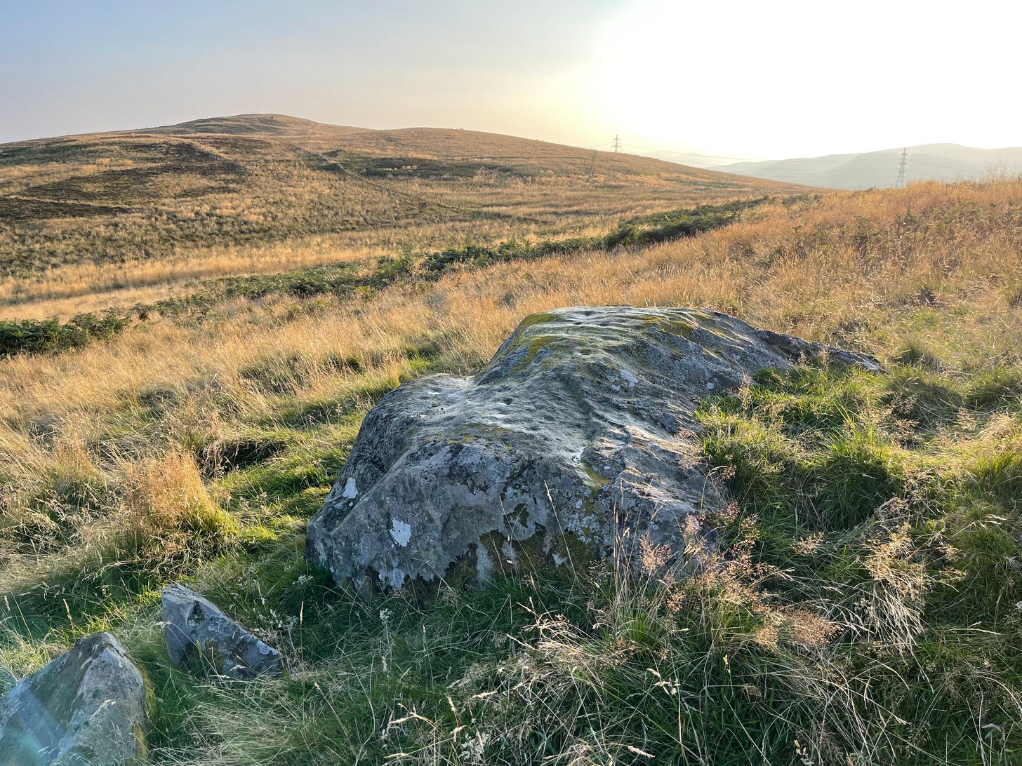
Take the same direction as if you’re visiting the Ardoch (2) carving, starting from the Foulford golf course on the A822, roughly halfway between Gilmerton and the entrance to the Sma’ Glen. From here, take the track eastwards into the hills and literally ¾-mile along you reach the pylon; keep going along the same track for another 200 yards and on your left watch out for the track-cum-footpath going up the slope past Ardoch (2), onto the hilltop, then through the gate and down the path northeast for about ⅔-mile until you reach the burn. Keep going uphill for 80 yards and through the cronky gate, head 70 yards to your left to the large single rounded boulder.
Archaeology & History
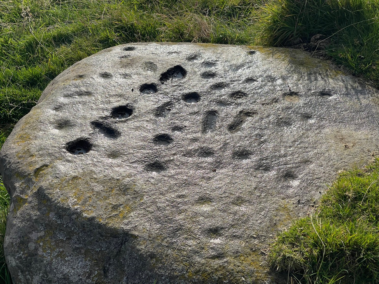
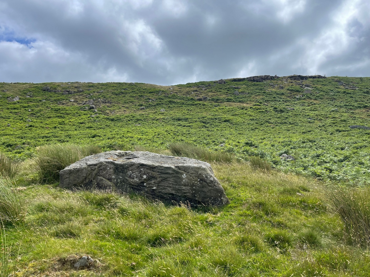
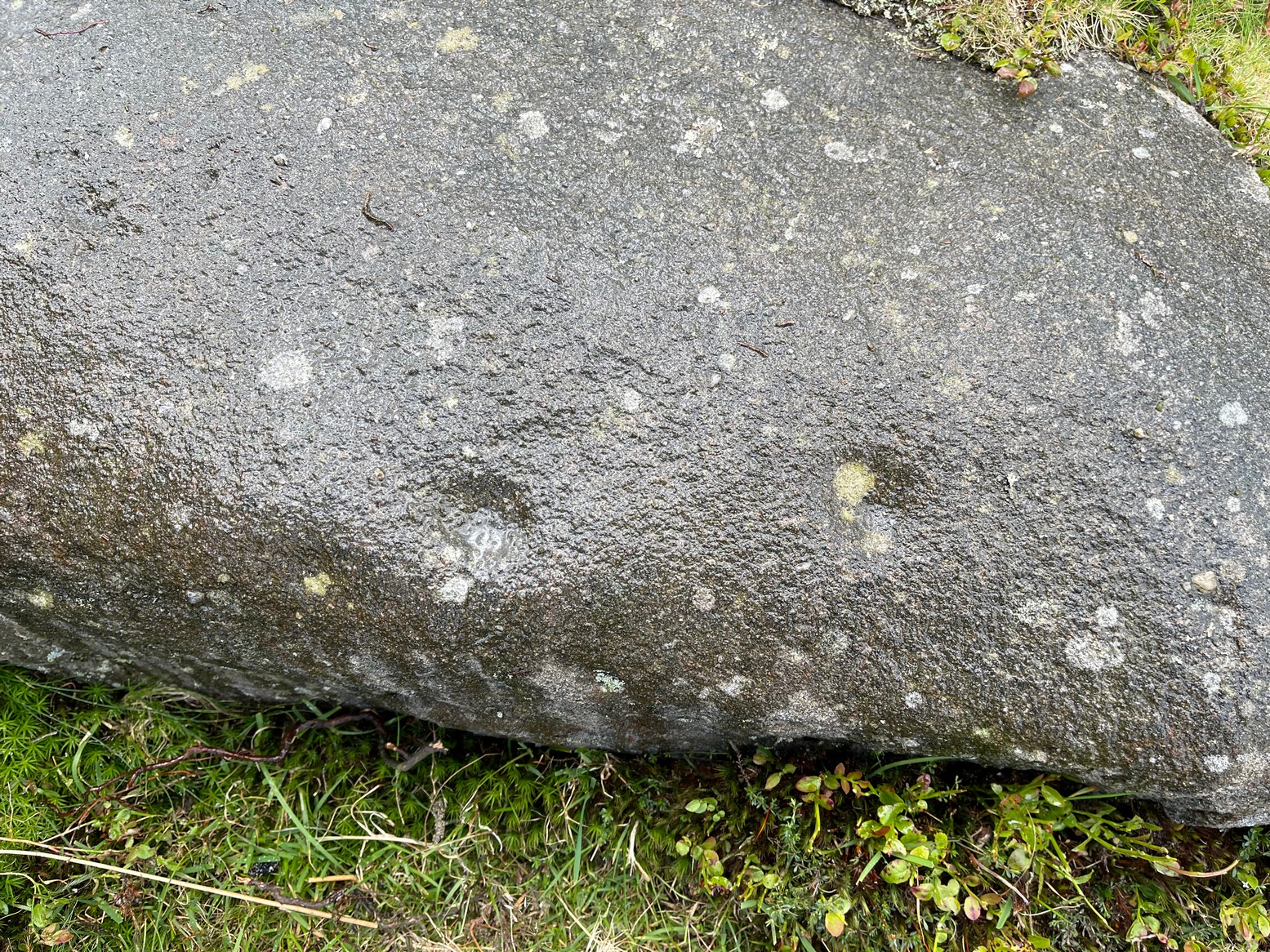
Main scatter of cups
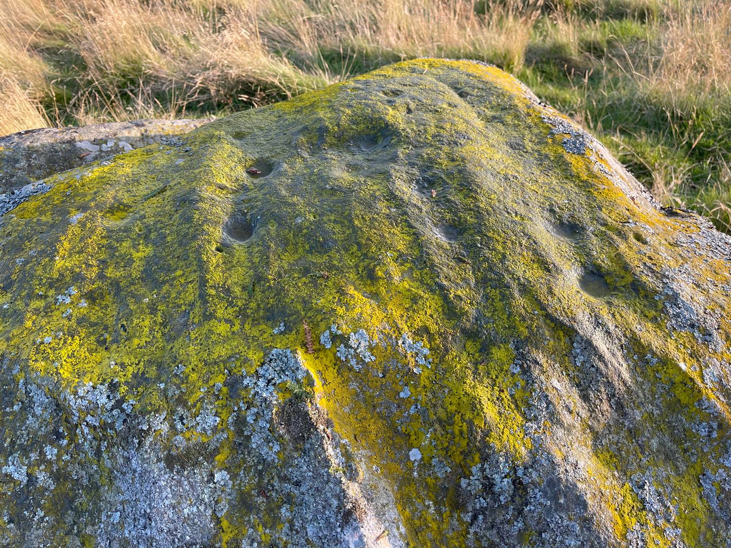
One of several petroglyphs in the area, this is the most notable in terms of its size. It rests just below the two Stroness hut circles which sit on the small level piece of ground nearly 100 yards further up the slope. A considerable scatter of cup-marks cover much of the upper surface of the boulder, some faint, some not so faint, with a number of them painted in a slight cover of lichens at the topmost section of the rock. The carving was first described somewhat blandly by George Currie (2004), who simply wrote:
“Large boulder, 2 x 2m, just W of hut circles; 16+ cups, 40–50 x 14–20mm.”
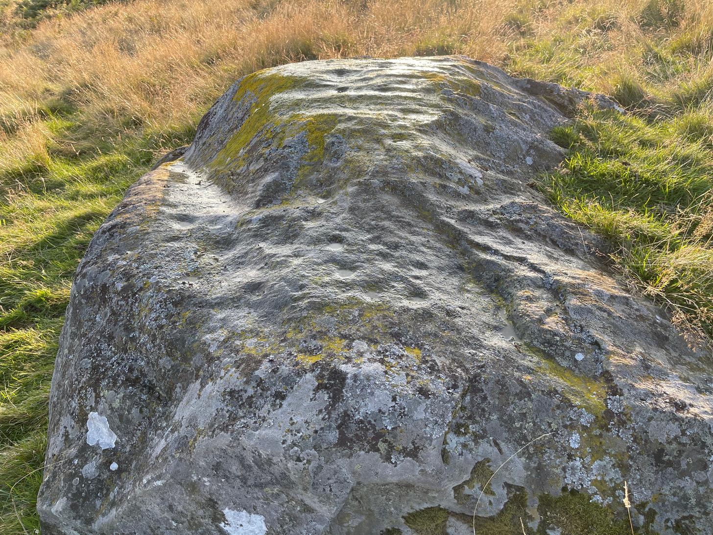
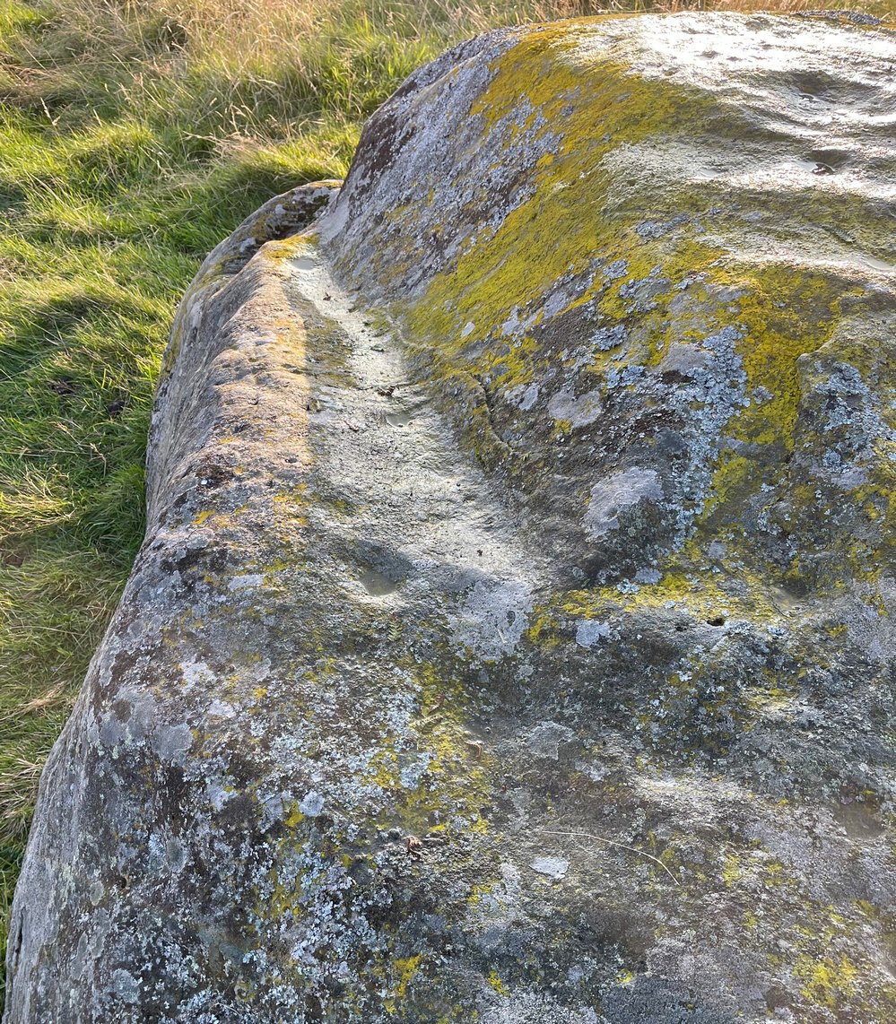
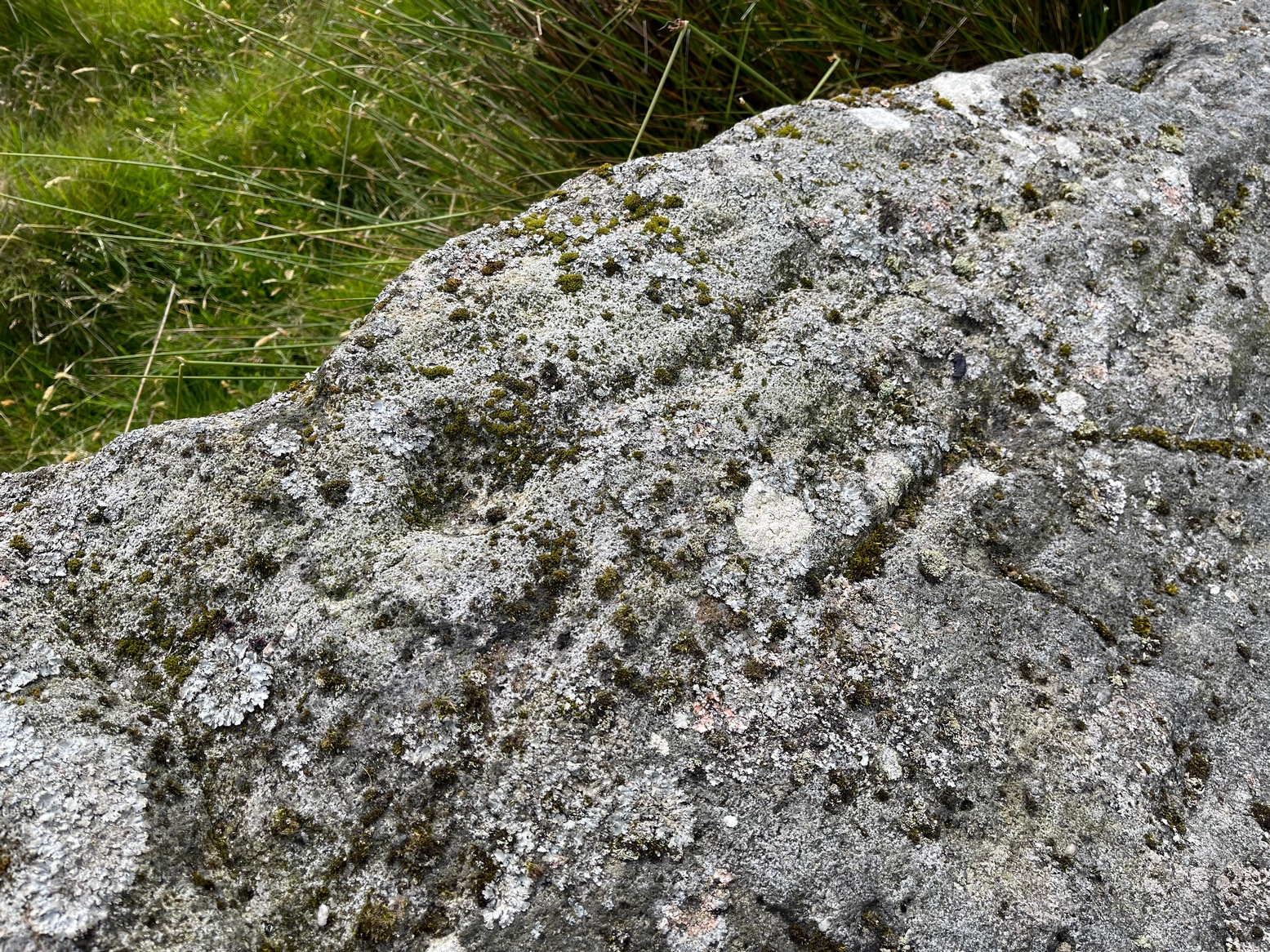
Faint line near the edgeCups among the lichens
It’s actually south of the hut circles; and there are certainly more than sixteen cup-marks, as the photos here indicate. At the time of my visit here recently, the sun was falling and was just below the level that permitted a perfect highlighting of the cup-marks, but there seemed to be at least 25 of them, scattered in no particular order over much of its upper surface. One curiosity that seemed apparent was a long carved line running along a long slender edge along on the southern side of the stone, from a large cup-mark down to near the southwestern edge, meeting another smaller cupmark. I not 100% certain that it’s actually been carved and it may just be one of Nature’s scratches along the rock, but it does seem to have that “man-made” stamp on it. Another visit in differing light will show us one way or the other.
References:
Currie, George, ‘Buchanty Hill (Fowlis Wester parish): Cup-marked Rocks’, in Discovery & Excavation Scotland, volume 5, 2004.
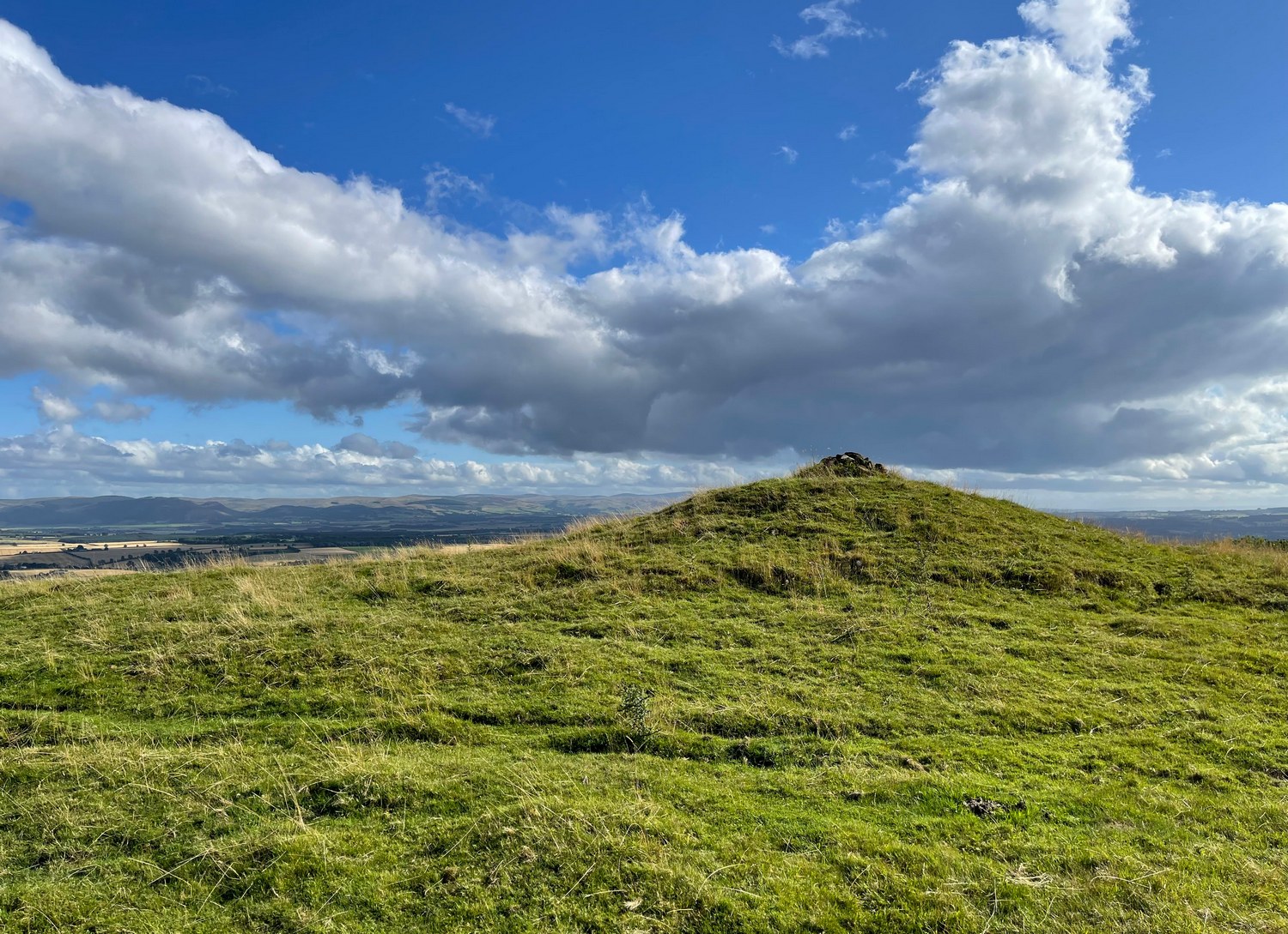
Ardoch (2) carving, with Milquhanzie hillfort behind
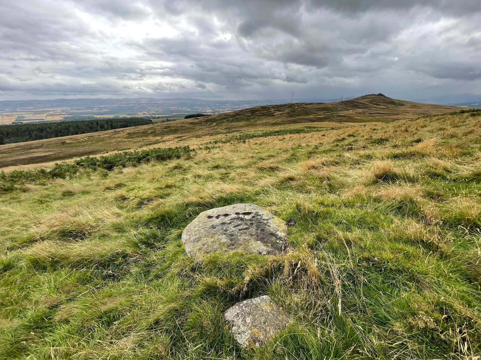
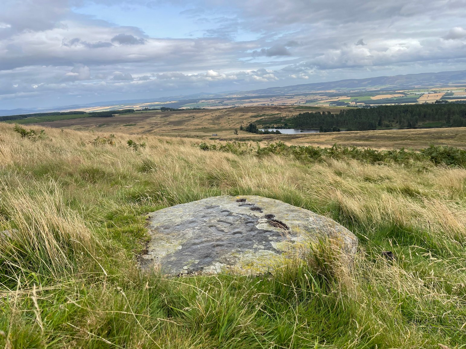
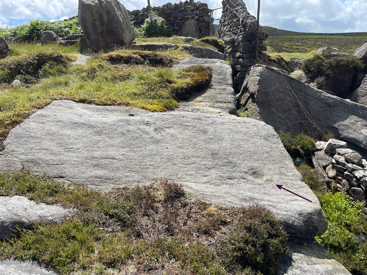
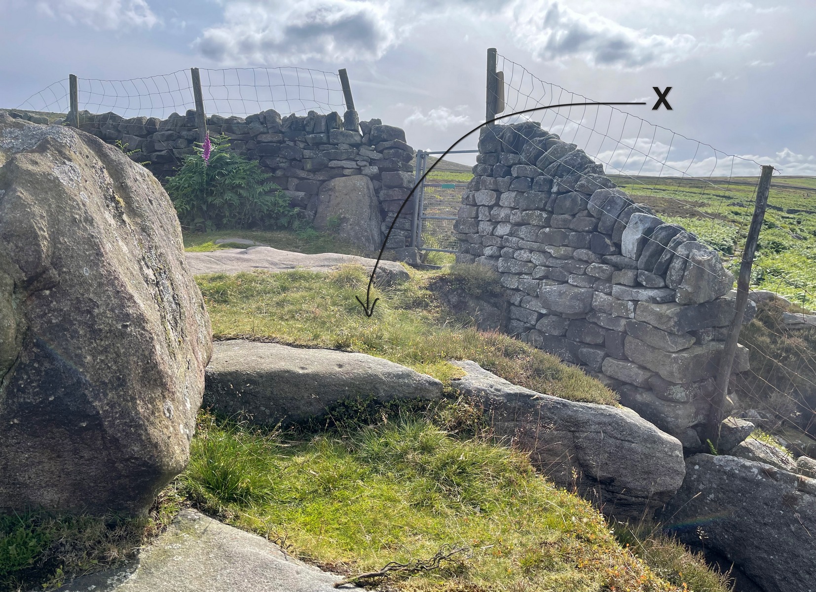
We took the long route to get here, via Fowlis Wester village, up to the car-park near the standing stones, then walk for 1¾ miles along the track: past the stones, veering right to go downhill then uphill, past the Ardoch (1) petroglyph and bearing right at the next split in the track, then right again at the next split. Then, crossing a small burn and curving round the next bend, keep your eyes peeled for the track-cum-footpath that reaches uphill on your right (NE). A shorter route is via the Foulford golf course (found along the A822 roughly halfway between Gilmerton and the entrance to the Sma’ Glen): take the track from there, eastwards into the hills, and literally ¾-mile along you reach the pylon; keep walking along the track for another 200 yards and on your left watch out for the same track-cum-footpath. Walk up there for about 400 yards and, 35 yards to the right of the fence, you’ll see a large flat stone.
Archaeology & History
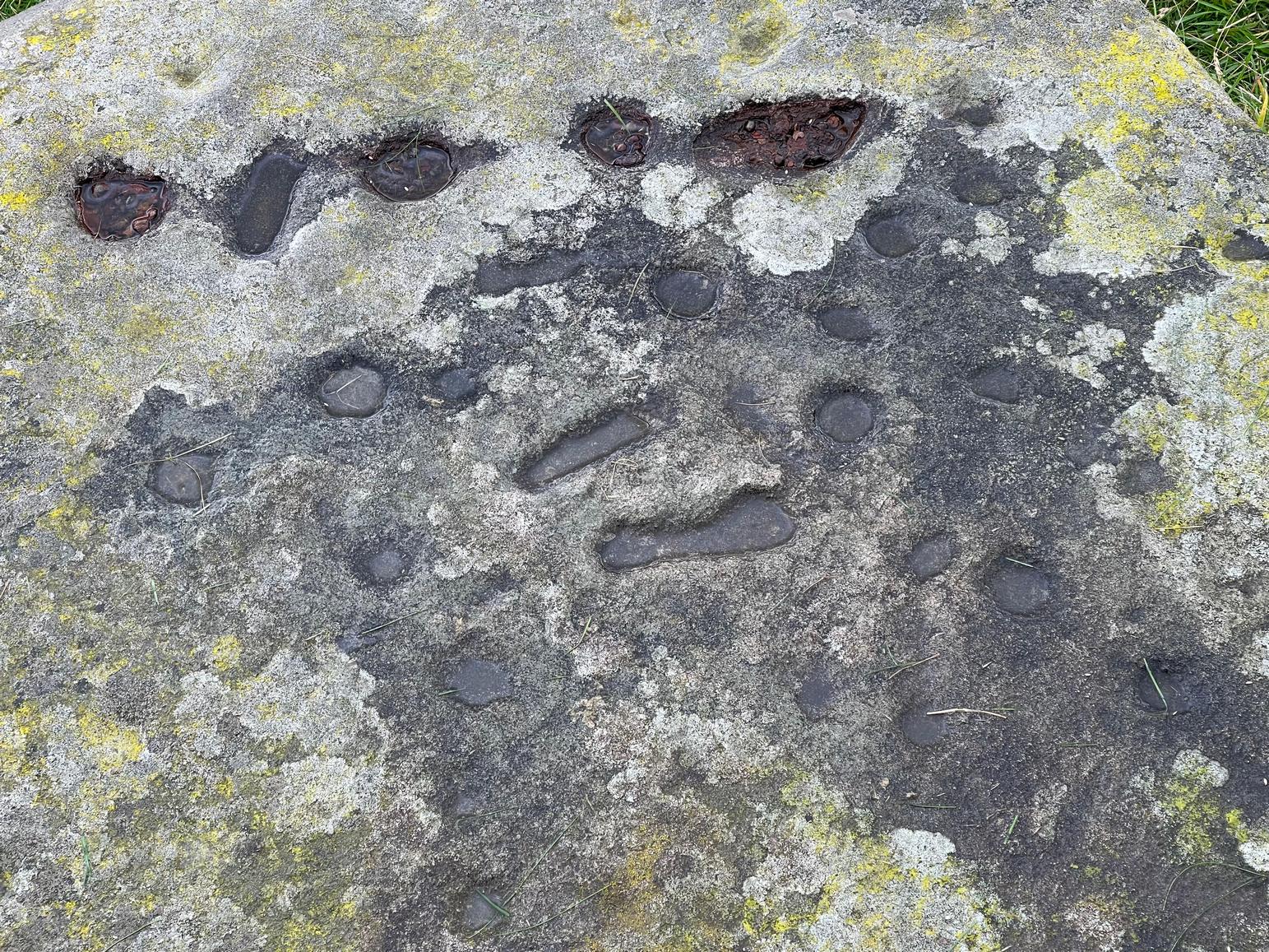
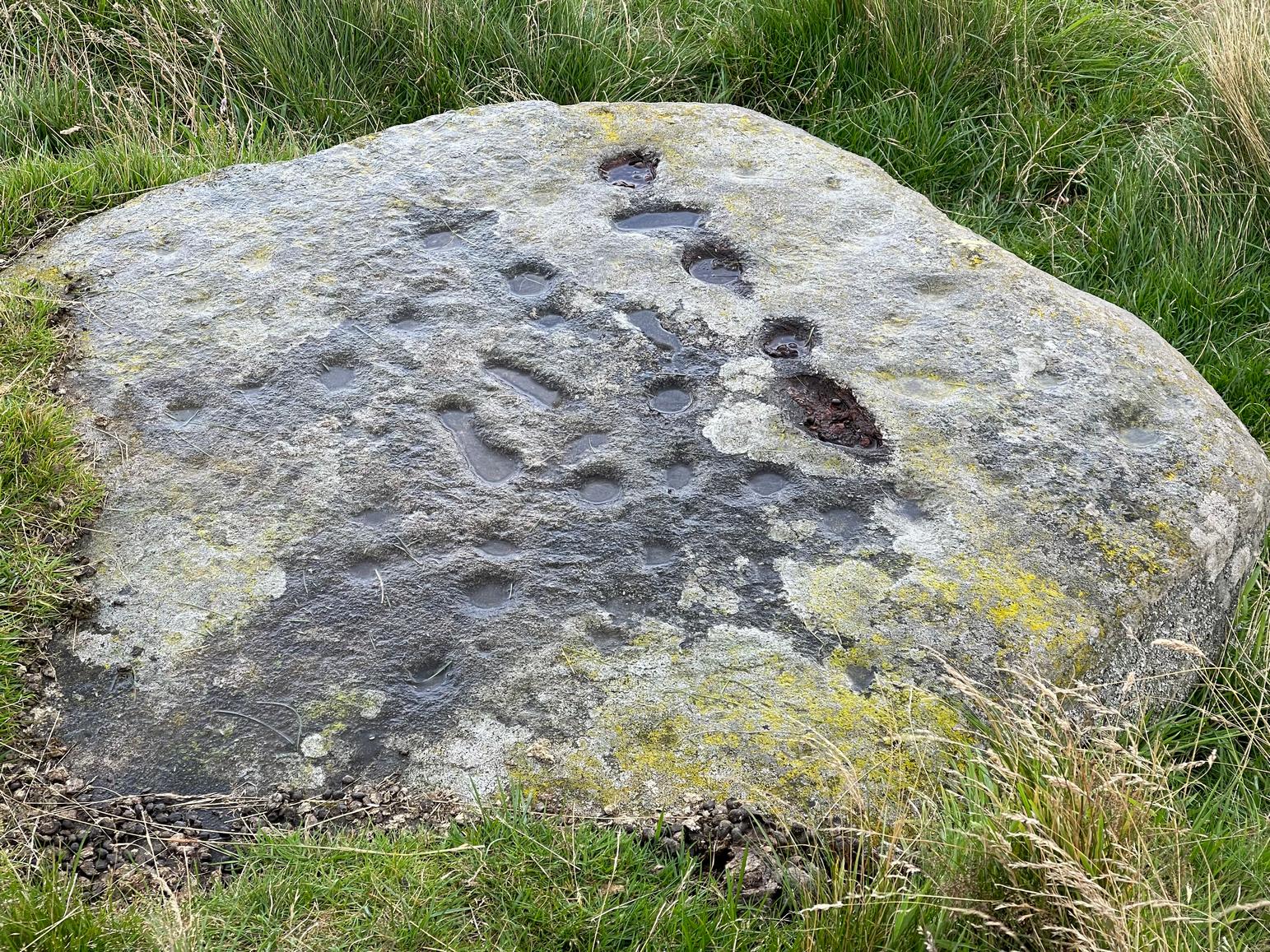
This is a most curious design, sitting way up near the top of this unnamed hill on its western face. It’s curious as there are number of odd elongated cup-marks which, to me at least, should be described as footprints. We find such designs on a few carvings (such as the one at Dunadd, and St. Columba’s Stone, etc), but they’re pretty rare. The best can be found on the Cochno Stone a few miles north of Glasgow, with additional toes on the design… but that’s for another site profile – and an essay, perhaps, should I ever get round to writing it! Anyhow…
It was first described, albeit briefly, by a Mr Comrie in 1972, who told us that,
“On a south-west facing slope of Buchanty Hill at 950ft is a boulder measuring 1.60m x 1.40m with 22 cups and 11 dumb-bells, 6 of which are distorted by a fault of quartz in the stone.”
Central “footprints”“Footprints” & cup-marks
But his description of what he saw as eleven “dumb-bells” is somewhat extravagant. Six, perhaps seven would seem the more probable. I was hoping to find that the Scottish Rock Art Project doods might have spent some of their million quid in doing a computer enhancement of this carving in order to confirm it one way or the other, but this was one of hundreds that they never looked at. Very poor… (and they only described two so-called dumb-bells here!) The only other mention I’ve found of the place is in Finlayson’s (2010) fine survey of local megaliths, but only in passing.
The dumb-bells or “footprints” on this carving are small: fairy footprints, one might say. The main ones are seen near the middle of the stone on its flat smooth surface. Another—perhaps two—occur along a curious geological cut that runs in a straight line, north-south (roughly) over the rock. This curious line has a series of deeply cut elements, mainly cup-marks, which give the impression of being enhanced or worked upon in much more recent centuries, looking almost as if they possessed some utilitarian function. They’re most odd and are certainly much younger than the very worn cup-marks that are scattered across the stone in no particular order. One of them seems to have a very faint ring around it. You can just make it out in one of the photos.
Looking southeastA nice close-up
So we’re looking at a multi-period carving done (probably) over several centuries. Some of the cup-marks are barely visible unless the light is just right. On my first visit here, the day was grey and overcast and some elements of the design were all but invisible; but on my second visit, on a beautiful evening, when wetting the rock, it shone out in all its splendour…. Well – as good as could be expected considering it may be five thousand years old! But the footprints are the stand-out features of the design.
In a lengthy essay on this motif that’s found on numerous European petroglyphs, Miroslav Verner (1973) points out several traditional and theoretical meanings ascribed to the symbol, which may be relevant to the stone here. The footprints may mark the rock as a pilgrimage site; or a representation of the location of a theophany, or genius loci. In some places it can be a signature of the so-called artist; or a symbol of victory; and even a symbol which possesses the power to cure fevers and other ailments. This latter tradition was known to have been practiced at the mightily impressive Blarnaboard (3) carving near Aberfoyle.
Another important feature of this carving its position in the landscape: more than a thousand feet above sea level, you sit here and the vista ahead of you reaches far far away into the distance from east to south to west. The skies above and around it are open and seemingly endless from here. It’s impressive and, most likely, these attributes are mythically significant to its meaning. Have a look at the place: take a day out and sit here for a while and get your own impression of the place. You’ll like it…
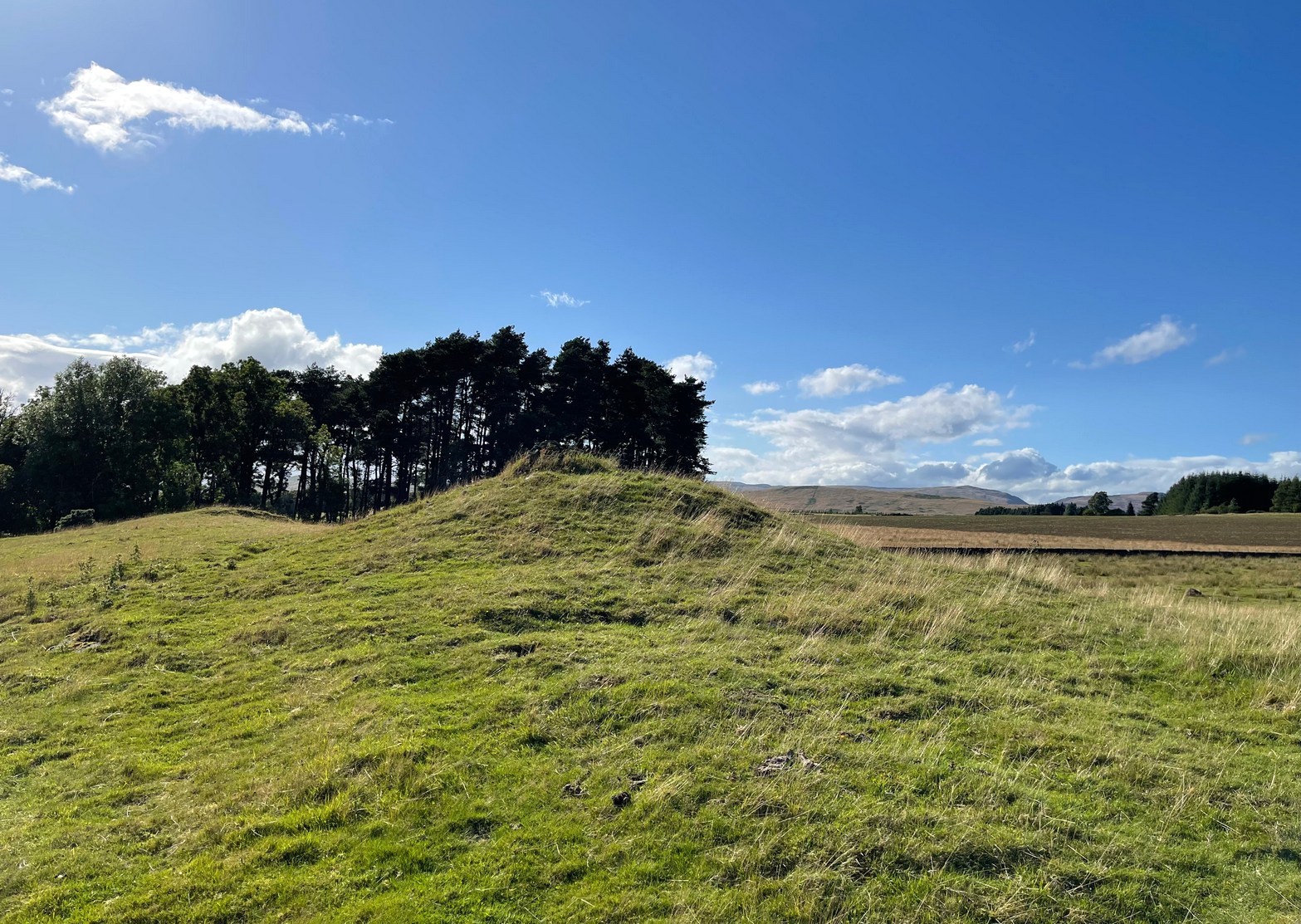
You need to hit the village of Fowlis Wester, which is easiest to approach from both east and west along the A85, between Crieff and Perth: nearly 3 miles east of Gilmerton and about 6½ mile west of Methven. Keep your eyes peeled and take the road up (north) where the large rounded tree-covered tumulus stands and up to the village. Go through the village and uphill for literally ½ a mile (veering sharp left at a junction) where a gate on your right leads into the fields. (a large parking spot is 300 yards further uphill) Walk ¼-mile east and through the other side of the small woodland, over the fence, you’ll see the mound of a typical tumulus. That’s it!
Archaeology & History
If you’re going to visit the megalithic remains of Fowlis Wester ¾-miles to the west, the antiquarians amongst you might as well give this old burial mound your attention too. It’s not grandiose by any means, but its position in the landscape is quite superb. It’s built upon a long geological promontory with extensive views that reach from south-east to south to south-west for many miles into the distance with the Ochils framing the majority of the southern horizon, but also with the notable pap of the West Lomond hill 20 miles to the south-east mimicking the shape of the tomb itself. It was obviously built here with the extended landscape having some ancestral importance. Visit it and see for yourself!
Despite being a notable mound, this tumulus-cum-cairn only seems to have been written about for the first time as recently as 1998, when archaeologist Ian Armit visited the site. Roughly circular in form, it’s about 12 yards across and more than six feet in height. A small pile of stones crowns the very top, placed here in much more recent times. At ground level on its northern side, an arc of low lying stones define the edge of the tomb. The stones probably continue all the way round the entire structure, but it’s overgrown by centuries of soil and vegetation and we lose sight of it as we walk round. When Mr Armit (1998) wrote about the site, he and colleague wrote:
Seat Knowe, looking NWSeat Knowe, looking north
“A grassed-over stony cairn lies on the highest point of Seat Knowe, a ridge commanding extensive views to the south. The cairn has a diameter of c.10m and is up to 2m high. A modern cairn occupies it summit. The low turf foundations of a rectilinear structure, some 6 x 8m, occupy its south flank, and thee are extensive cultivation and field system remains in the vicinity.”
Check it out! You won’t be disappointed.
Folklore
An interesting piece of relatively recent folklore about Seat Knowe, described in the Perthshire Name Book around 1862, told that,
“One of the Earls of Strathearn, desirous of having a church in the vicinity of his Castle, stood on an eminence, on which he had a summer seat, and resolved to erect it where the sun first shone, which was on the spot where it now stands.”
References:
Armit, Ian & Hall, M., “Seat Knowe (Fowlis Wester parish): Cairn,” in Discovery & Excavation Scotland, 1998.
For those who like a walk: take the route to reach the Swastika Stone and keep walking west along the Millenium Way footpath, past the Piper’s Stone carving and over the next two walls. Then, stagger down the steep hill and head for the large upright near-cuboid block of stone and, once here, walk 30 yards to your east! Alternatively, from the Silsden-side, go along Brown Bank Lane up and past Brown Bank caravan park, and at the second crossroads turn right and travel for exactly 1¼ miles (2km) along Straight Lane (from hereon there’s nowhere to park!) which runs naturally into Moorside Lane, and notice the raised gate entrance into the field on your right. Walk to the top of this field, go through the next gate and, less than 100 yards uphill (south) you’ll find the stone in question.
Archaeology & History
Cup, incomplete ring & line
Rediscovered by Paul Bowers in 2011, this is another one of those petroglyphs that’s difficult to make out unless the light is falling just right across the surface of the stone. Two distinct cup-marks can be seen near the more southern-edge of the stone, one of which has a near-complete, albeit unfinished ring around it, and from this a seemingly carved line runs roughly parallel with the edge of the stone, down towards another equally distinct cup close to the southwestern edge of the rock. Most of the stone is nicely covered in a decent lichen cover, so the design’s a bit difficult to see when the light’s not right. But, if you’ve made it this far, the petroglyph 30 yards to the west will make up for any disappointment you may have!
References:
Boughey, Keith & Vickerman, E.A., Prehistoric Rock Art of the West Riding Supplement, 2018.
Get up to the Swastika Stone, then head west along the footpath towards the Piper Stone. Shortly before there, you’ll see the small cup-marked Piper’s Crag (3) carving, just by the walling. From this carving, just step a few yards down the slope and on the smooth sloping rock face is this faded carving. You’ll see it.
Archaeology & History
A larger than normal single cup-mark near the bottom slope of this rock has an incomplete ring around its east and southern edges, possibly with another broken element of it on its northern edge. It’s difficult to work out whether or not this is one of Nature’s curious markings and so needs looking at in different lights to work it out, one way or the other. It’s included in Boughey & Vickerman’s (2018) updated rock art survey, but there are a number quite natural cup-marks in that tome, so we need to exercise a little bit of caution here. However, it does seem to have a greater degree of authenticity than some of the other dubious single cup-marked stones in their book. Check it out on your way to the Piper’s Stone.
References:
Boughey, Keith & Vickerman, E.A., Prehistoric Rock Art of the West Riding Supplement, 2018.
Heading up from Ilkley, follow the directions to reach the Swastika Stone, then keep walking (west) along the footpath to the small clump of trees, and keep walking past them too and keep going along the same path as if you’re heading toward the Piper’s Stone. About 200 yards before reaching it, just where the gate and boundary stone is in the old walling, there’s a small line of crags to the right of your feet and there, at the edge of the path, is the stone in question. You’ll see it (unless it’s a cloudy gray day, in which case you might struggle).
Archaeology & History
The two cup-marks
This is one of a number of cup-marked stones that you’ll find scattering this part of the moor, almost all of which are Nature’s handiwork (a few of these natural carvings have somehow found their way into Keith Boughey’s [2018] updated West Riding rock art book). I’m not 110% certain that this doesn’t have Nature’s name on it either, but it’s got a greater degree of probability to it than some of the others. It’s a simple little thing, as y’ can see, consisting of just the two cup-marks, smaller than usual, living next to each other. If it’s the real deal, we can surmise that it may have been carved by a young person back-in-the-days. In the walling just above this stone you can see the medieval boundary stone, which might—just might—have a prehistoric pedigree to it….
References:
Boughey, Keith & Vickerman, E.A., Prehistoric Rock Art of the West Riding Supplement, 2018.
Cup-and-Ring Stone (lost): OS Grid Reference – NN 880 252
Archaeology & History
A long lost carving, probably quite impressive in design, was recorded by John Laurie, schoolmaster in Monzie. He told us that,
“a large Druid stone with rude carving upon it lies on the side of the public road between the villages of Monzie and Keppoch. This stone was one of a Circle which Mr Monroe, the then minister, caused to be broken and dispersed.”
When Fred Coles looked for the remains of this “circle” at the beginning of the 20th century, he questioned Laurie’s location of the site, but found remains of one in an adjacent field consisting of two stones, but told that “on neither of them could we discern any carving of any sort.” It’s likely that the carving has been completely destroyed, or if we’re lucky it may be hiding in some nearby walling.
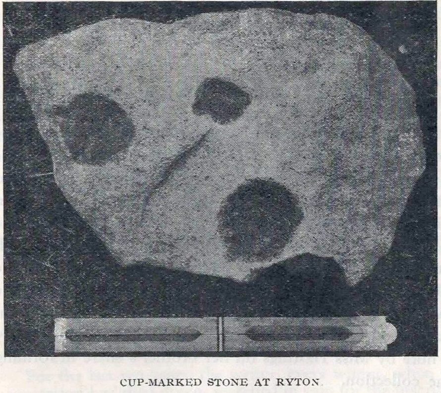
Cup-Marked Stone (removed): OS Grid Reference – NZ 1480 6417
Archaeology & History
Ryton cup-marked stone
In a short piece read before Newcastle’s Society of Antiquaries in 1942, a Mr Cocks (don’t laugh!) told that when a friend of his was clearing out an old land drain in his garden, he found this fragmented cup-marked stone, “which had been made use of as a corner slab on the drain”! It was located “about 40 yards south-west of Tweedy’s Buildings,” on the west side of town. Broken from a larger piece of stone, the attached photo here shows the simple design of the basic cup-marks, measuring respectively 2½, 2 and 1⅝ inches across. Mr Cocks told that “there are also two finger-tip hollows on the stone tone which or may not be natural. A dark line running between the cups is a natural fissure.”
Last we heard, the stone was living in a box somewhere in the archives at the Great North Museum, Newcastle.
References:
Cocks, W.A., “A Cup-Marked Stone at Ryton,” in Proceedings Society of Antiquaries Newcastle-upon-Tyne, volume X, no.2, January 1943.
Cup-and-Ring Stone (lost): OS Grid Reference – SE 0965 4797
Archaeology & History
In Ronald Morris’ (1989) gazetteer of British petroglyphs, he included this curious entry but gave no real details regarding its appearance or history. Listed by the Royal Commission lads, it would seem to have been located immediately south of the dismantled railway where it used to cross the Addingham-Ilkley road, but no one seems to have seen it either before or since Morris’ description. Any help regarding its whereabouts would be appreciated.
References:
Boughey, Keith & Vickerman, E.A., Prehistoric Rock Art of the West Riding, WYAS: Wakefield 2003.
Morris, Ronald W.B., “The Prehistoric Rock Art of Great Britain: A Survey of All Sites Bearing Motifs more Complex than Simple Cup-marks,” in Proceedings of the Prehistoric Society, volume 55, 1989.
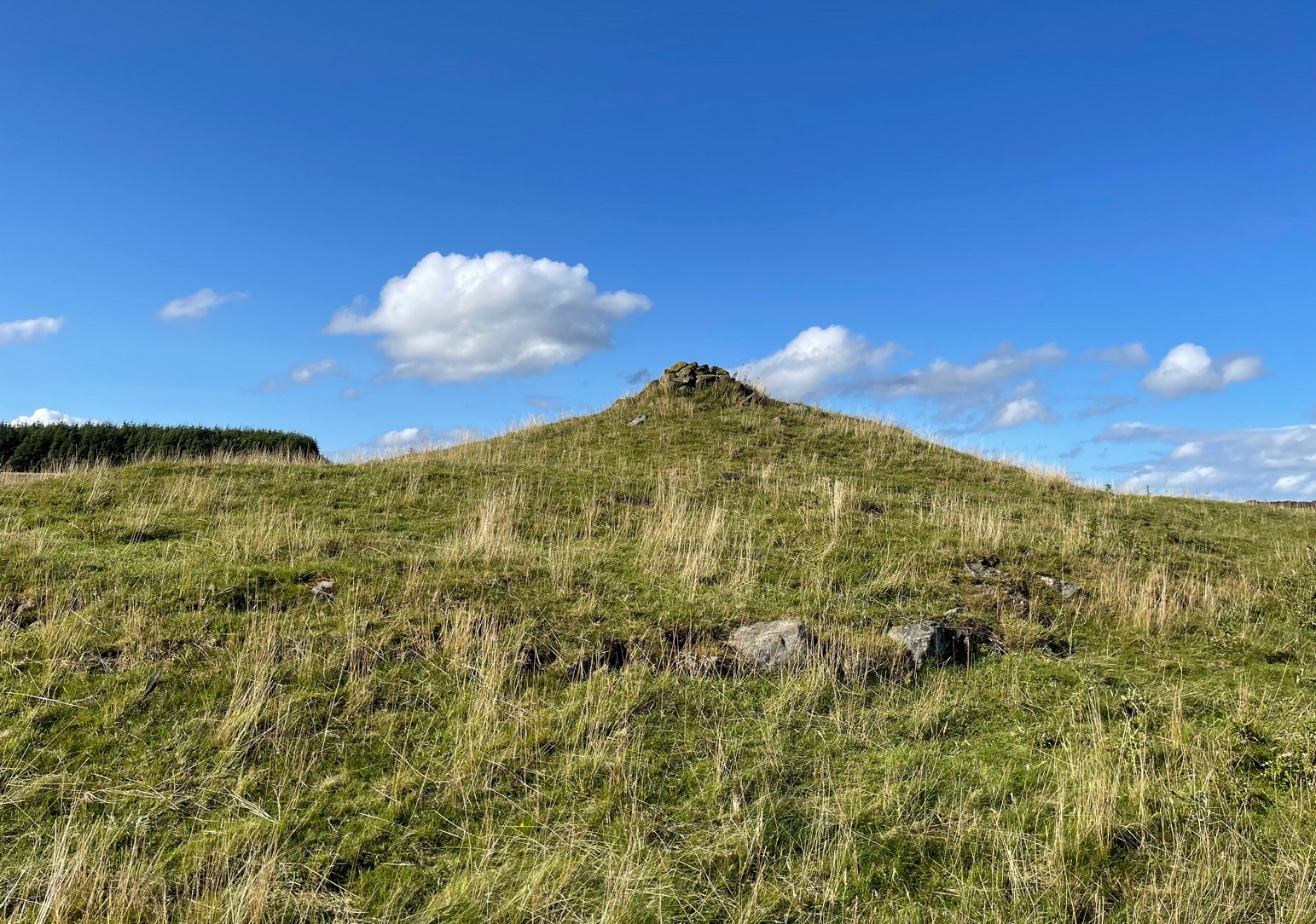
If you’re coming via Ilkley, cross the bridge to Middleton and turn left, following the long winding road for several miles until you hit Langbar village. If you’re coming via Bolton Bridge, go to Beamsley village and turn left up Lanshaw Bank until you hit Langbar village. Whichever of the two routes you use: on the north side of Langabr village is a distinct small rough car park. From here, cross the road where the footpath sign is and walk straight up the steep hill to Beamsley Beacon at the top. You can’t miss it!
Archaeology & History
At the highest point on these hills, 1300 feet up, we come across this ancient prehistoric cairn. Its position in the landscape is impressive to say the least, being visible from nearly every direction on the moorland heights for many miles around, as well as being conspicuous from the riverlands below. A visit to the site nowadays shows it surmounted by a more recent mass of small stones turning it into a large walker’s cairn with only its compact base showing any real sign of antiquity.
Site shown on 1853 mapWestern side of the cairn
Mentioned briefly in parish records from 1658 onwards, it was highlighted on the earliest OS-map as simply a Beacon hill, due to it being used for beacon fires. We’re not certain when its beaconesque function first came about; and, it’s possible, that its beacon element could have replaced a much earlier heathen fiery function, typical of many hilltop sites up and down this and other countries. But we do know that such fires were lit here at the beginning of the 19th century. The great Harry Speight (1900) told that of its
“use as a prospecting-point and beacon there is no doubt. In the Bolton Abbey registers, under date 1803, is this entry:
“Apprehensive of a French invasion, Beamsley Beacon was put in a state of repair, and four people appointed to watch it. About — of the inhabitants of this chapelry inrolled themselves as Volunteers, the whole number of whom in Craven amounted to 1,200 Infantry and 200 Cavalry. A Sergeant was appointed to drill the volunteers of this chapelry at Bolton.”
The beacon at this time received light from Pinhaw on Carlton Moor and sent it forward to Otley Chevin, as appears by an old chart at Wakefield, dated 1803.”
The beacon’s ancient name of Howber Hill is literally the Hill of Tombs, as derived from the Teutonic haugr, and Anglian how, being a burial mound; and berg is a hill, sometimes fortified. Whilst there seems to be no evidence of ancient fortification, compacted cairn material at the base seems to confirms the -how element. Yet despite Speight citing this etymology, he was was somewhat sceptical wondering, instead, if the site was merely a giant boundary marker—which it has been for centuries.
A short distance along the footpath to the east is the denuded old cairn known as The Old Pike. Further east still, along the same boundary line, there was once another old tomb, long since gone…
Folklore
I’m not sure whether this should gone in the folklore section or not. But, well, it’s here nonetheless! In Guy Phillips’s (1976) book on the mythic history of ancient Brigantia, he describes a number of alignments, or leys (not one of those stupid energy lines, which has nowt to do with leys)—one of which crosses Beamsley Beacon. It’s an west-east line that begins at Cockerham and from there goes,
“through Top of Blaze Moss SD 619525, Slaidburn (it is very clear here), Flambers Hill SD 877523, southern edge of Copy Hill 952523, Draughton (extremely clear), Beamsley Gibbeter and Beamsley Beacon, Heligar Pike, Scow Hall 203523, Little Almscliffe Crag, Tockwith church and on to the coast.”
I have to say that I’m sceptical of the veracity of this alignment.
References:
Bogg, Edmund, Higher Wharfeland, James Miles: Leeds 1904.
Cobley, Fred, On Foot through Wharfedale, William Walker: Otley 1880.
Phillips, Guy Ragland, Brigantia – A Mysteriography, RKP: London 1976.
Smith, A.H., English Place-Name Elements – volume 1, Cambridge University Press 1956.
Smith, A.H., The Place-Names of the West Riding of Yorkshire – volume 5, Cambridge University Press 1963.
Speight, Harry, Upper Wharfedale, Elliott Stock: London 1900.
Acknowledgements: Huge thanks to James Elkington for use of his photo on this site profile. Cheers mate. 😉