Cup-Marked Stone: OS Grid Reference – SE 1395 4517
Getting Here
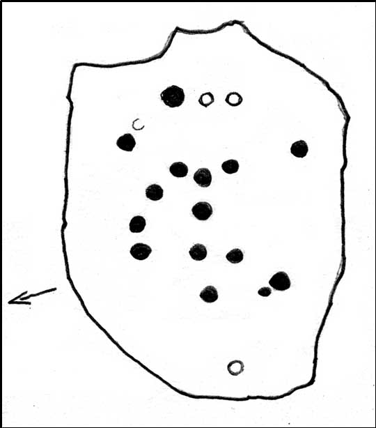
Sketch of the main design
Once you’re on Ilkley moorland itself, head over to the Little Skirtful of Stones giant cairn. From here, walk due east for 115 yards where you’ll come across an overgrown dried-up (usually) dyke cut into the heath, which runs roughly north-south. Walk over the dyke onto its eastern side and just a few yards in front of you, in a slight dip, you’ll found a female oval-shaped boulder amidst the heather.
Archaeology & History
Rediscovered on Tuesday March 6, 2012, this medium-sized rounded (female) rock has somehow evaded all previous archaeological evaluations. It is one of at least five previously unrecorded cup-marked stones found close to each other on the eastern section of Rombald’s Moor near the Little Skirtful of Stones. The rock measures roughly 2 yards by 1½ yards and possesses at least 15 cup-marks that cover most of its surface. Each cup-mark averages about 2 inches across and are less than ½-inch deep. There is a natural ‘bowl’ in the southern section of the rock with a typical cup-mark in it and a smaller one in close association.
Dyke Stone cupmarksand from another angle
The other cup-markings found close by, appear to be associated with the prehistoric cairns but this stone — the largest of the group — lacks any immediate relationship with such monuments. Further ground explorations are required at other potential spots close by; plus we could do with getting back here when the sunlight’s better, so we can get some clearer photos!
From the Idol Stone carving, keep walking along the footpath that takes you up the hill and further onto the moor. Keep walking for another few hundred yards until you reach the old pits at Lanshaw Delves. Walk due east through the heather for 250 yards or so, until you hit the flat-topped cup-and-ring marked Lanshaw Stone. Walk 50 yards NNE from here, and keep diligent. You’ll find it!
Archaeology & History
…and from another angle
This is another carving which is troublesome to locate when the heather’s fully grown. Like other cup-and-rings scattered along this geological ridge, it is associated with additional prehistoric features which local archaeologists have never bothered plotting: a real peculiarity, as this is a truly rich archaeological arena. Low walling and cairns are close by, all from the Bronze Age and possibly earlier. When we were children exploring this section of the moor, we also found a few flints scattered about (we threw ’em back into the peat, where they probably still remain). The carving itself may be neolithic, but in all honesty until we get a decent archaeologist in the area willing to truly focus on our ancient monuments, we’ll never know the time periods of the remains here with any certainty.
When Boughey & Vickerman (2003) recorded this and other carvings nearby, they described it simplistically as:
“Medium-sized, rounded, triangular rock of medium grit, up to height of heather at centre. Two cups, of different size, and perhaps another.”
I’m not too sure about another to be honest, but I’d love to be wrong! A curious straight line may run parallel to the cups, but this too may be natural. I reckon the carving’s only gonna be of interest to the real rock-art fanatics out there. But nearby, as you’ll find, are more impressive archetypal cup-and-rings…to be described later…
References:
Boughey, Keith & Vickerman, E.A., Prehistoric Rock Art of the West Riding, WYAS: Leeds 2003.
A bit hard to locate. Take the route past the Haystack Rock onto the Idol Stone and Idol Rock, uphill, for a few hundred yards till you meet the distinct vegetational change and pits of Lanshaw Delves that run east-west. At this point on top of the path, walk to your left, due east, for 270 yards (247m), staying along the top of the ridge, then when you reach the flat-topped cup-and-ring marked Lanshaw Stone, head due north going down the heathery slope for about 50 yards until you find this reasonably large though flat earthfast stone. If you wanna locate it, you’ll find it!
Archaeology & History
Close-up of cupmarks
On an excursion that was exploring the relationship between prehistoric tombs and rock art in the area, this shallow carving was found that had, in a confusing way, been mis-catalogued in the archaeology registers – which confused us poor simpletons at the time! Initial investigation indicated one primary cup-marking near the east-side of the stone, but when highlighted there was the possibility of another faint cup on the same section of the rock, just above the obvious one – but this still isn’t clear.
Cup-marks in better light
Found in association with other prehistoric remains close by, the carving is one that will probably be of interest just to those hardcore rock-art freaks amongst you. However, there are a dozen other carvings close by, several of which are impressive cup-and-ring designs. It’s one of around 50 cup-and-ring carvings on Rombald’s Moor that’s not in the Boughey & Vickerman (2003) survey — and this isn’t an easy one to see unless the lighting conditions are right. This low rounded (female) rock has, since its initial discovery by the hardworking Mrs Potts, been stripped of its vegetation by members of the Ilkley CSI team when they found it for themselves. Worth looking at if you’re exploring the other carvings nearby.
Get to the Cow & Calf Rocks, go up across the car-park as if you’re gonna go up onto the moor and walk up the steep footpath uphill to the left of the crags. Once you get level with the crags, take the footpath bending left and walk along here for 110 yards, keeping your eyes peeled for the low smooth rock on the right of the footpath, just where another path meets it. You’ll find it.
Archaeology & History
Close-up, from above
This quiet little stone has seen better days. Nearly destroyed a few weeks ago when the Emmerdale Farm film-crew churned up sections of the moor right over the side of this carving—but thankfully it still remains intact (you or I would have been prosecuted for such damage).* The carving is a simple one in graphic terms, comprising simply of three cup-markings, all on the southern side of the rock. Close to several other petroglyphs (the Wray Stone is 78 yards north and several other more ornate carvings are close by), the carving was first described in the Hedges (1986) survey as a “small, low smooth grit rock sloping slightly NW to SE in crowberry, bilberry, grass and bracken. Three clear cups.” But it has to be said, one of them is fading fast. Let’s hope this humble little carving doesn’t fall prey to those who are gradually turning our moorlands into a park.
References:
Boughey, Keith & Vickerman, E.A., Prehistoric Rock Art of the West Riding, WYAS: Leeds 2003.
Hedges, John, The Carved Rocks on Rombald’s Moor, WYMCC: Wakefield 1986.
* As the footpaths on Ilkley Moor continue to be widened and paved by those who reckon they like these moors, it’s obvious that more prehistoric sites up here are going to get damaged. It’s difficult to see what the local archaeologist or Natural England are doing to ensure that these environmentally-damaging schemes don’t encroach on the mass of rich prehistoric sites on the moors, most of which have never been adequately assessed (the philosophy of “if we don’t know it’s there, it doesn’t matter if we destroy it” seems evident in some of those working for the local council). Before any work or structures are dug on Ilkley Moor, an archaeological assessment is, I believe, supposed to take place – but I think this ‘work’ consists merely of looking at their own limited records, without any detailed fieldwork being undertaken. As we know from research undertaken by rock art students at TNA, CSI and elsewhere, there are still many cup-and-ring stones, cairns and archaeological features constantly being discovered on these moors that are not in the record books.
From Ilkley, take the Wells Road heading towards White Wells, bending round the bottom of the moor, making sure you keep left along Westwood Drive (not further up the moor along the Keighley Road). Keep along Westwood Drive – it becomes Panorama Drive after a while – until you come to the small copse of woods on your right, a short distance before the end of the road. Go along the footpath by the wall at the side of the house, bending into the woods after 10 yards. Another 10 yards on, you’re near the edge a drop down the slope, where a number of large rocks are seen. Look around!
Archaeology & History
Carving 236 (after Boughey & Vickerman)
A singular cup-and-ring carving can be seen, rather faintly, near the nose-end of this large mossy stone, close to the edge of the ridge. It is one of a small cluster of carvings that remain in this small bit of woodland. Other highly ornate carvings could once be seen in the same stretch of woodland — where the rich houses now stand — amidst remains of a prehistoric enclosure or settlement of some sort. All remains of this settlement have been destroyed, which is a pity as it may have given us helpful information about the nature of this carving and its nearby relatives.
References:
Bennett, Paul, The Panorama Stones, Ilkley, TNA: Yorkshire 2012.
Boughey, Keith & Vickerman, E.A., Prehistoric Rock Art of the West Riding, WYAS: Wakefield 2003.
Hedges, John (ed.), The Carved Rocks on Rombalds Moor, WYMCC: Wakefield 1986.
Cup-and-Ring Stone (lost): OS Grid Reference – SE 1015 4702
Also Known as:
Panorama Rock 226
Archaeology & History
J.R. Allen’s 1879 drawing
It would seem that this excellent looking cup-and-ring stone may have been destroyed sometime around 1890 during the construction of the Panorama Reservoir and the building of the houses on the southwestern edge of Ilkley, right by the moorside. But this isn’t known for certain; and the carving could still exist beneath vegetation in the trees just north of the reservoir. In requesting to explore some National Archives data in which there may be information relating to this carving (and others nearby), I was directed to Bradford Council’s community archaeologist, Gavin Edwards (to whom requests should be made), but he denied access to look at the files, then completely ignored subsequent queries that might enable us to locate this and other important prehistoric carvings. So we did our best and this is what we’ve found so far (forgive any errors).
As there’s a slight ambiguity in the precise location of this lost carving, we cannot say for certain whether or not this site was included in the sale of Property Lots, numbers 7-34, “surrounding the far-famed Panorama Rocks,” which may have led to the site’s destruction and subsequent removal of the protected Panorama Stones to Saint Margaret’s Park on the other side of the road from the church, closer to Ilkley centre. The sale of this “building land” as it was called was advertised in the Leeds Mercury, Saturday September 4, 1880, with a brief description of the respective “lots” near this and the adjacent carvings. But this Panorama Stone 226 may have been left alone and be buried under the surface…
J.T. Dale’s 1880 sketch
Historical notes on this particular stone are scattered and sparse, but digging through old journals and texts has given us a reasonably good vision of the place. It was first described, albeit in passing, in A.W. Morant’s edited third edition of Whitaker’s History of Craven (1878: 289), where it was described in context with the other cup-and-ring east of here on the same ridge. All of them were described as being located within a now-destroyed prehistoric enclosure (precise nature unknown), with carving 226 at the westernmost end. However, the following year J. Romilly Allen (1879) gave more details of this, “the third stone” as he called it and furnished us with a damn good drawing to boot!
As we can see, there are four double-ringed cups and eight or nine archetypal cup-and-rings, with the usual scatter of cups falling across the design. The curious ‘ladder’ markings found on one of the other Panorama Stones, the Barmishaw Stone, Willy Hall’s Wood carving and at least one of the Baildon Moor carvings, were also quite prominent. Although when J. Thornton Dale visited here around the same time and did his own drawings, the ladders weren’t quite as pronounced. This would have been due to the simple factors of cloud cover, poorer sunlight and the time of day the drawings were done (the pseudoscientific proclamation of local archaeologist Gavin Edwards that such artistic difference is due to some Victorian chap adding, or removing sections of the carvings for his own pleasure, negates common sense and is strongly lacking in evidence). Romilly Allen’s own description of the site was as follows:
“The Panorama Rock lies one mile south-west of Ilkley, and from a height of 800 feet… About 100 yards to the west of this spot appears to be some kind of rough inclosure, formed of low walls of loose stones, and within it are the three finest sculptured stones near Ilkley. They lie almost in a straight line East to West… The third and most westerly stone of the group measures 10ft. by 9ft. and lies almost horizontally, having its face slightly inclined. On it are carved twenty-seven cups, fourteen of which have concentric rings round them. Some of the cups have connecting grooves, and three have the ladder-shaped pattern before referred to.”
Notes from a few years later told that this carving was still in situ when the companion carvings were moved and imprisoned behind railings across from St. Margaret’s Church in Ilkley. The carving was shown at the grid reference given above on the 1895 Ordnance Survey map of the region before the reservoir was built, correcting the coordinates given in Boughey & Vickerman’s (2003) otherwise fine survey. They described this very ornate carving thus:
“According to Thornton Dale (1880), this was a large rock with 27 cup, eighteen of which had single rings. Some of the cups had connecting grooves and three had the same ladder motif as the Panorama Stone.”
…to be continued…
References:
Allen, J. Romilly, “The Prehistoric Rock Sculptures of Ilkley,” in Journal of the British Archaeological Association, volume 35, 1879.
Allen, J. Romilly, “Notice of Sculptured Rocks near Ilkley,” in Journal of the British Archaeological Association, volume 38, 1882.
Allen, J. Romilly, “Cup and Ring Sculptures on Ilkley Moor,” in The Reliquary, volume 2, 1896.
Bennett, Paul, The Panorama Stones, Ilkley, TNA: Yorkshire 2012.
Boughey, Keith, “The Panorama Stones,” in Prehistory Research Section Bulletin, no.40, Yorkshire Archaeological Society: Leeds 2003.
Boughey, K.J.S. & Vickerman, E.A., Prehistoric Rock Art of the West Riding, WYAS: Leeds 2003.
Collyer, Robert & Turner, J.H., Ilkley: Ancient and Modern, William Walker: Otley 1885.
Jennings, Hargrove, Archaic Rock Inscriptions, A.Reader: London 1891.
Turner, J. Horsfall, “British or Prehistoric Remains,” in Collyer & Turner, Otley 1885.
Whitaker, Thomas Dunham, The History and Antiquities of the Deanery of Craven in the County of York, (3rd edition) Joseph Dodgson: Leeds 1878.
Walk from Ilkley up the Wells Roads as if you’re going to the White Wells, but keep following the road along, keeping to the moorside (don’t go up Panorama Drive). A few hundred yards up, crossing the small bridge over the gorse-scattered stream, take the footpath to your right and walk along the moor-bottom, parallel to the rich houses. Keep walking, past the reservoir (don’t go up the slope on the newly created path) and cross the small wooden bridge. Once over the other side, head through the gate and walk along the rocky footpath into the woods. Less than 100 yards down where the first seat is, there’s a slow-running blood of water oozing out from the rocks.
Archaeology & History
At the top of this bit of old woodland, out of rocks near the top of the trees, emerges another of Yorkshire thousands of chalybeates, or iron-bearing springs of water, on the very edge of Ilkley Moor. Collyer and Turner (1885) mentioned its discovery in 1883, but gave no further details. Searching for this place on one of my countless moorland ambles as a child, I found its waters oozing slowly from betwixt moss-enriched rocks on the west side of the stream. If you look for it in the dry season though, there is little to see. It is best seen later in the year, after heavy rains, although the waters are pretty slow running and have that distinct “off” taste (an attribute well-known of chalybeates —taste ‘em and see!). The only real account of this little-known healing well was told in an early edition of the Leeds Mercury (1883), shortly after its rediscovery, in which we were told:
“Our Ilkley correspondent says the existence of a chalybeate spring has lately been discovered there, and from its valuable medicinal properties will prove a valuable adjunct in the future development of this health resort. The water from the spring (which is situated near to the Panorama Rocks, in what is known as Hebers Gill, or Briery Wood) has been submitted to Mr F.M. Rimmington…of Bradford for analysis and his report is of a most favourable character. The data shows that the water is remarkable for the smallness of the amount of its saline constituents, and (so far as the analyst has been able to discover by reference to published analysis of either English or Continental chalybeate springs), there is not one comparable to it: whilst its ferruginous element is equal to the majority of such waters and, in Mr Remmington’s opinion, as large as is desirable for medicinal effect. The spa that most resembles the one under notice is that of Tunbridge Wells in Kent, which is derived from exactly the same geological formation (millstone grit), the total solid constituents of this water being 13½ grains to the gallon. The report adds that, “The use of this class of waters as medical agents has, from remote periods, been found efficacious in those states of debility denominated anemia,” and “the value of this class of spa water as a safe and natural remedy can scarcely be overestimated.” From the foregoing it will be seen that an important discovery has been made…”
This once important spring of water — that would have been known and used by our prehistoric ancestors living on the moors above — is nowadays but a shadow of its former self. The water tables drop annually as a result of moorland drainage and other poor land management and we only see a small trickle of water emerging from the mossy rocks these days…
…to be continued…
References:
Anonymous, “Important Discovery at Ilkley,” in Leeds Mercury, August 18, 1883.
Bennett, Paul, Healing Wells and Springs of Ilkley Moor, unpublished: Hebden Bridge 1995.
Collyer, Robert & Turner, J.H., Ilkley: Ancient and Modern, William Walker: Otley 1885.
Follow the same directions to reach the superb Badger Stone carving, and from here take the footpath that runs downhill. You’ll cross another footpath about 100 yards down the moor, but just keep walking down the path and you’ll notice the small copse of woods ahead of you. As the footpath begins to swerve roughly away, northeast, heading away from the said woodland, keep your eyes peeled on your left for a reasonably large but flattish rock close to the ground (in summer it’s surrounded by bracken) about 75 yards away. That’s your target!
Archaeology & History
Of the hundreds of cup-and-ring stones on Ilkley Moor and district, this is one of my personal favourites! I first visited the stone in 1977 as a young teenager and was mightily impressed by the unusual nature of the design here — and that impression still remains. Aswell as possessing the usual cups and rings, the Barmishaw Stone is one of just a few rocks also possessing a sort of ‘ladder’ design or linear pattern within the overall carving: an insignia echoed on the nearby Willie Hall Wood carving, the Piper Stone, and also on the Panorama Stones. As with the ‘ladders’ on the Panorama carving, those found here at Barmishaw are very eroded and are increasingly difficult to see during the daytime (the best time to notice them is usually around sunrise or sunset, and particularly when the rock itself is wet).
The carving has been described many times, albeit briefly, by a number of writers. In John Hedges (1986) fine survey he said the following:
“Medium sized flat-topped rock…fairly smooth grit, sloping slightly east to west, covered with carvings, some of which are very worn. Slanting sunshine needed to detect them. About twenty-four cups, at least nine with rings or incomplete rings, two with multiple grooves half round and continuing straight down, one of them incorporating ‘ladder.’ Five other ‘ladders’ – in a good light. Cups mostly deep and clear.” A few years later, Boughey & Vickerman (2003) echoed much of Mr Hedges description, though noted that of the 24 cups with their rings, one possessed a triple ring.
Alan Davies’ illustration
Like so many cup-and-ring stones, they have given rise to hosts of fascinating theories and ideas — one of which is based on mathematics and metrology. In the 1980s, Alan Davies (1983, 1988) surveyed the Barmishaw Stone — and other carvings on Ilkley Moor — to explore the possibility that the cups and rings were laid out according to a basic unit of measure, the Megalithic Inch (MI), as proposed by Alexander Thom some years earlier. Although Davies’ work showed that such a primary unit of measure wasn’t to be found universally, his research at the Barmishaw Stone indicated “significant evidence for quanta of…3 MI,” although this occurred “when the analysis is restricted to only ringed cups.” Despite this, Davies thought that the existence of the Megalithic Inch was evident in this and other carvings on the moors, stating that:
“The repeated emergence of the significance of ringed cups, and the fact that all putative quanta seem to bear a simple numeric relation to each other do not seem to be coincidental.”
Although it has to be said that the selectivity of data in Davies’ research is more indicative that the Megalithic Inches in the the carvings was due, neither to chance nor mathematics, but more that the implements used to carve the rocks and the size of the hands of the people doing the carvings was pretty uniform and so, as a result, would give an obvious window of numeric similarities that can easily be mistaken as a deliberate metrology. These simplistic factors need assessing. In modern trials that we’ve done carving cup-markings, we’ve found them to be of similar size to those carved in prehistoric times—as you’d expect.
Barmishaw Stone (after Hedges, 1986)Barmishaw stone (Cowling 1946)
The ladder motif central to this carving may have related to early religious and ritual events here. Across the world, indigenous cultures commonly relate the ‘ladder’ to be a symbol of ascension, both by shamans, mystics and during rites of passage. The symbol represents the journey of the soul to and from supernatural realms. To discount this possibility at the Barmishaw Stone would be shortsighted.
The carving was very probably painted when our neolithic ancestors gathered here, much as Australian aborigines still do to their carvings using lichens and other plant dyes, with the respective ladders and lines changing colour where movements between worlds or shifts of attendant spirit occurred. By virtue of the its very name, I consider this rock to have been considerably important; the “ghost” aspect to barmishaw being a typically misconstrued aspect of ‘spirit’.
Folklore
This excellent cup-and-ring marked stone probably derives its name from the old dialect words “barm i’ t’ shaw”, meaning “ghost in the wood” stone. Whatever guise the attendant spirit of this rock may have had has long since been forgotten; though spectral accounts from the beginning of the nineteenth century until modern times may give us clues. There have been several reports of green-coloured elemental creatures around the area between here and the White Wells sacred spring a short distance to the east. The most recent account, from 1987, took on the modern mythic form of a little green man from space, with attendant UFO to boot! The Barmishaw Hole nearby was a place where faerie-folk used to live. Excesses of geological faulting and water makes the magickal nature of this place particularly potent.
References:
Allen, J. Romilly, “The Prehistoric Rock Sculptures of Ilkley,” in Journal of the British Archaeological Association, volume 35, 1879.
Allen, J. Romilly, “Notice of Sculptured Rocks near Ilkley,” in Journal of the British Archaeological Association, volume 38, 1882.
Bennett, Paul, “Cup-and-Ring Art”, in Towards 2012, volume 4, pp.83-92, 1998.
Bennett, Paul, The Old Stones of Elmet, Capall Bann: Milverton 2001.
Boughey, Keith & Vickerman, E.A., Prehistoric Rock Art of the West Riding, WYAS: Wakefield 2003.
Cowling, E.T., ‘A Classification of West Yorkshire Cup and Ring Stones,’ in Yorkshire Archaeological Journal 1940.
Cowling, E.T., Rombald’s Way: A Prehistory of Mid-Wharfedale, William Walker: Otley 1946.
Davis, Alan, ‘The Metrology of Cup & Ring Carvings near Ilkley in Yorkshire,’ Science Journal 25, 1983.
Davies, Alan, ‘The Metrology of Cup and Ring Carvings,’ in Ruggles, C., Records in Stone, Cambridge University Press 1988.
Eliade, Mircea, Patterns in Comparative Religion, Sheed & Ward: London 1958.
Hedges, John (ed.), The Carved Rocks on Rombalds Moor, WYMCC: Wakefield 1986.
Wright, Joseph, The English Dialect Dictionary – volume 1, Henry Frowde: Oxford 1905.
From Ilkley town centre, taken the road north across the River Wharfe, turning left and up the country lane towards Nesfield. As you’re driving with the farmed fields on either side, you’ll go round a couple of swerves in the lane and reach the open moorland on your right, just past the small copse of trees on the same side. There’s a small place to pullover on the right 100 yards on and walk up the footpath running northeast onto the moor. Go past the disused quarry and up further till you reach the rounded hill where the tumulus stands.
Archaeology & History
On the moors north of Ilkley – as shown on OS-maps since the 1850s – on the southeastern edge of Middleton Moor, is this singular tumulus, a short distance west of some old quarrying at the curiously-named Lurgy Delf. The small hill is easy to find and appears at the western edge of a whole host of neolithic and Bronze Age remains. It is included as a boundary marker between Middleton and Langbar, as marked by an old stone on its southern side. Eric Cowling (1946) described this as “a spread of stones on Round Hill” in the same context as other burial mounds and cairns in the region, also naming it as the Black Hill tumulus. Many flints had been found all round here and it stands at the western edge of a great number of cup-and-ring stones, stretching eastwards across the moors for several miles. To my knowledge, no excavation has taken place here.
References:
Cowling, Eric T., Rombald’s Way, William Walker: Otley 1946.
From Silsden, take the moorland road up to Brunthwaite (ask a local if you’re in doubt). As you get near the top of the moorland road, take the right turn (east) on the track past the Doubler Stones, until you reach the last cottage before the woodland called Black Pots. Go onto the moorland behind the cottage, walking north, crossing the stream and you’ll see a large boulder stuck on its own close by. That’s it!
Archaeology & History
Stuart Feather’s 1964 image
On another wander on these moors t’other day, we ventured to the Doubler Stones and whilst there I had a vague recollection of another decent-looking carving west of them, just above the hidden house at Black Pots, when I was a teenager. When I got home I rummaged through some of my old notebooks and found the drawing I made of it all those years ago. Tis a decent carving consisting of 3 distinct cups encircled, though not completely, in an elongated arc. A cup-and-ring is just above this, and Boughey & Vickerman (2003) highlight another couple of cups which I didn’t manage to see when I was there as a kid. Nor for that matter did Stuart Feather, who was the first person to write about it in the Cartwright Hall Archaeology Group Bulletin in 1964. Itis a good carving in a good spot, with excellent views to the south and west.
References:
Boughey, Keith & Vickerman, E.A., Prehistoric Rock Art of the West Riding, WYAS: Leeds 2003.
Feather, Stuart, “Mid-Wharfedale Cup-and-Ring Markings: no.24 – Black Pots, Silsden, near Keighley,” in Cartwright Hall Archaeology Group Bulletin, 9:7, 1964.
Hedges, John, The Carved Rocks on Rombald’s Moor, WYMCC: Wakefield 1986.


")


")
")
")


")