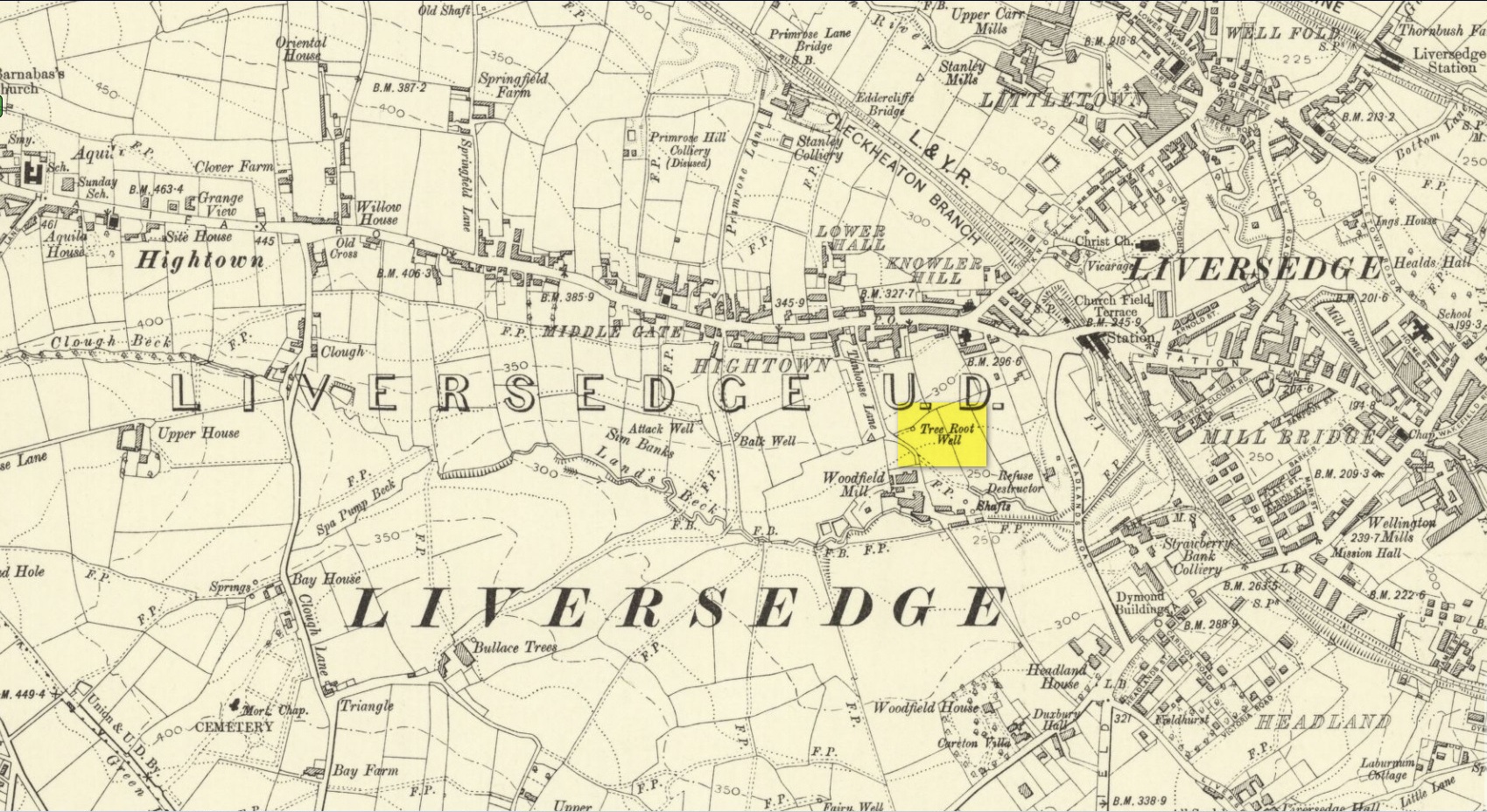
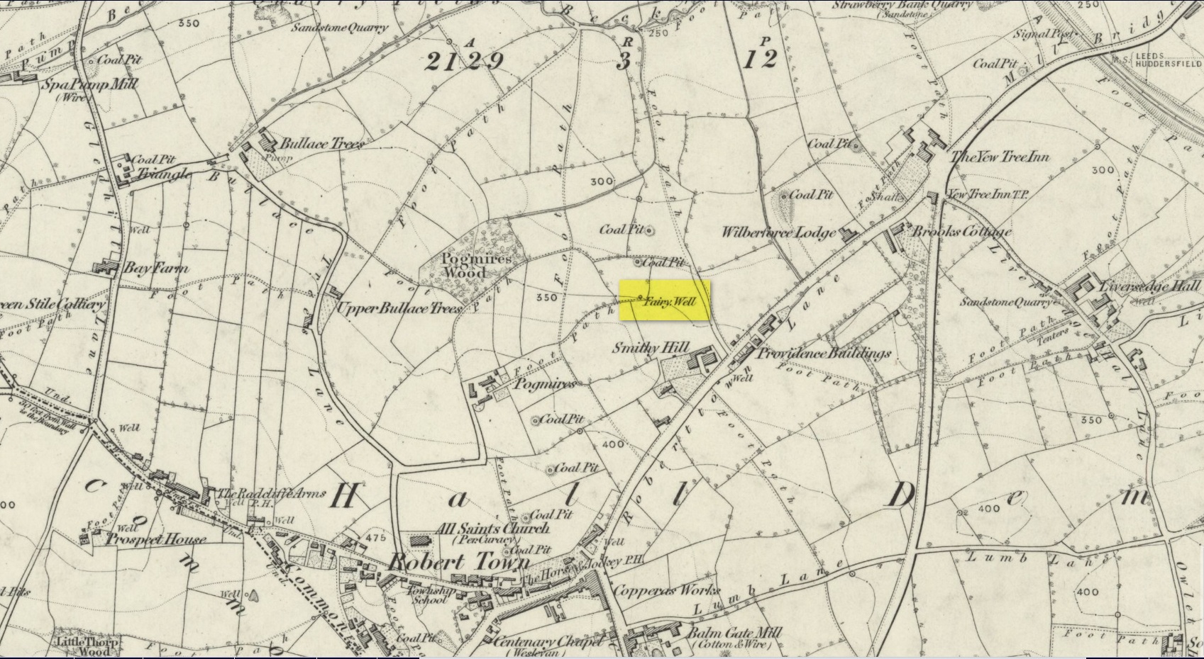
Along with the nearby Attack Well and Balk Well, this was one of three water supplies for the people of Middle Gate between Hightown and Liversdge in the 19th century. Found near the bottom of the old track known as Tanhouse Lane, its waters emerged at the base of some Victorian walling that’s built into the hillside, above which are the decayed remains of what seems to be an old hawthorn tree, whose roots obviously reached down to the stone trough, giving the place its name. Its waters have long since dried up and fallen back to Earth. Although it is shown on the 1908 OS-map of the region, I can find no virtues ascribed to the well nor any local history notes.
Acknowledgements: Huge thanks to the great Gary Ferner, for help in locating the site and the day’s venture!
Holy Well (lost): OS Grid Reference – SP 66 59 (approximate)
Archaeology & History
In George Baker’s (1822) massive regional history work he spoke of the village being “well supplied with springs, one of which, called Holywell, is medicinal.” But it would seem to have fallen foul of that thing called progress, as no one has spoken of it since then. When the Northampton historian, Beeby Thompson, looked for the site early in the 20th century, his enquiries drew a blank and he reported simply that “at the present time no one in the village appears to know of such a well.” A field-name survey of the area may prove worthwhile…
References:
Baker, George, The History and Antiquities of the County of Northampton, J.B. Nichols: London 1822.
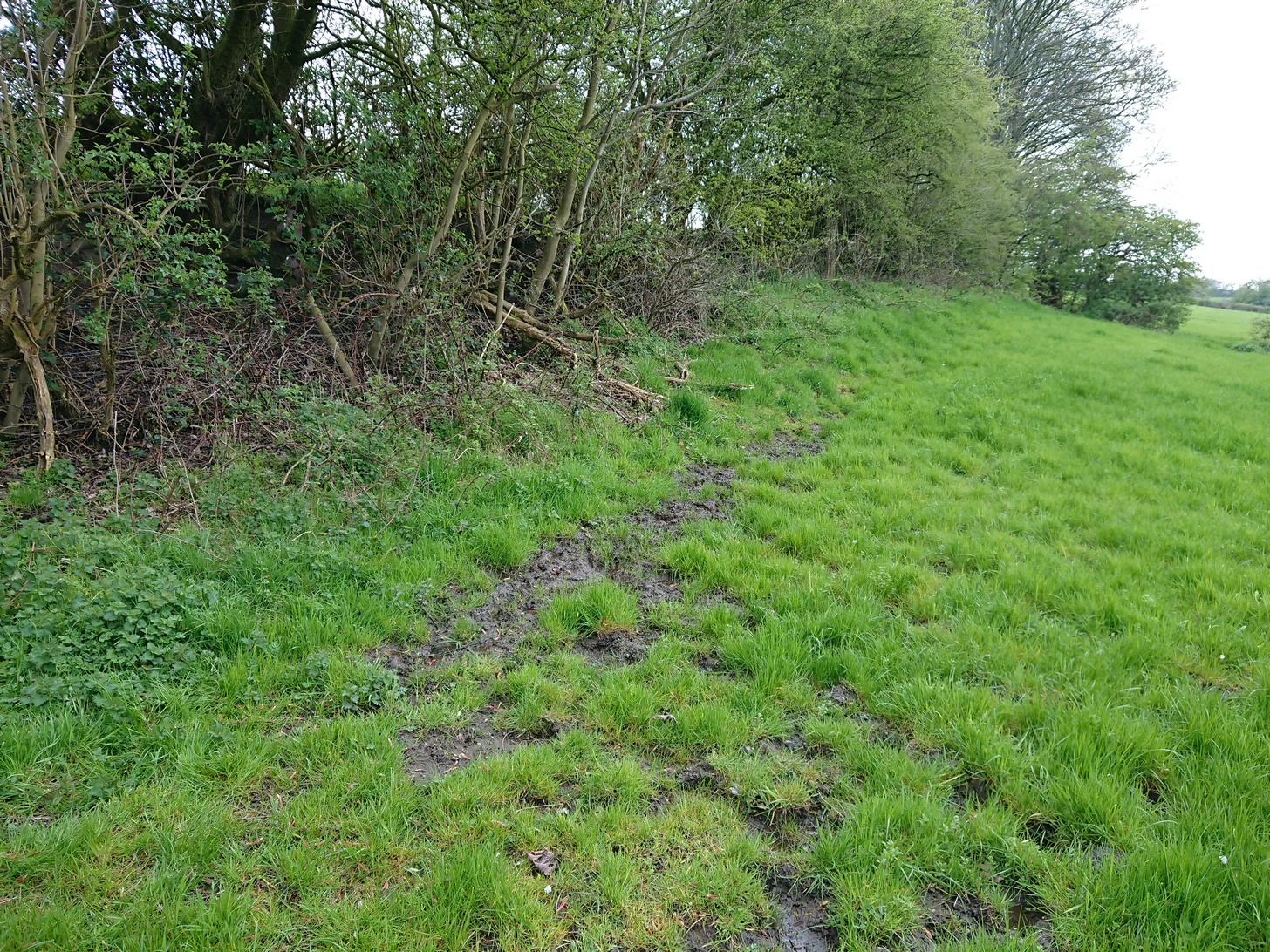
Best approached from Heckmondwike/Liversedge and going up Roberttown Road where, just past the Spen Valley High School parking spot, an almost dead straight footpath takes you down (northwest) into the woods. Walk down here for about 100 yards and then go left over the stile into the small copse of trees. Once you come out the trees at the other side, walk up the slope in the field that you’re now in. As you approach the line of trees at the top, you’ll notice the ground gets very boggy. Look carefully under the trees and you’ll notice an embedded flat stone protruding out and a somewhat trivial trickle of water into the grass at the front. That’s it!
Archaeology & History
Site on the 1854 OS-map
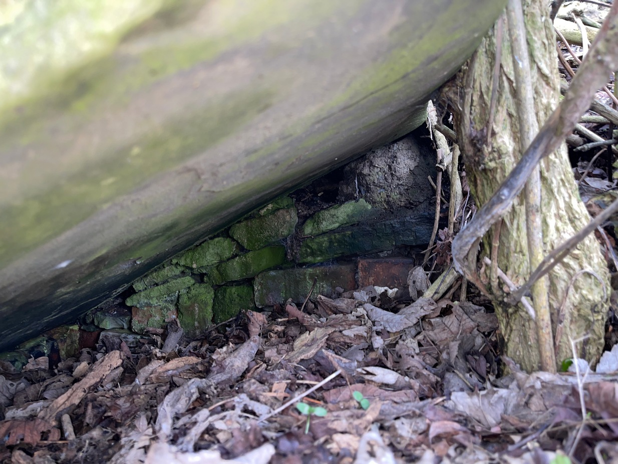
Highlighted on the 1854 Ordnance survey map of the area, this is a somewhat ruinous site which has seen better days. Even after good downpours it’s not very obvious and, in truth, could do with being cleaned-up, cleared out, and brought back into the old life it once had. If you look carefully beneath the roots of the covering tree, you’ll notice a decent-sized flat worked stone sticking out at the bottom of the sycamore and below this, at the back, almost covered in earth, you can make out some brick walling at the rear. It takes some finding! This is evidently the remains of a small protective well-house, now in total ruin.
Old cover of the well
When we visited the place a few weeks ago, there seemed to be no water inside. Instead, the water emerges into a small bog just below the tree-line a few yards away from the covering slab from whence it originally flowed.
Folklore
Obviously the abode of fairy folk in bygone days, all trace of the folklore and habits of them seems to have been lost long ago….
Acknowledgements: Huge thanks to mi old mate Gary Ferner for helping us uncover the source of the waters, which was almost completely covered in soil.
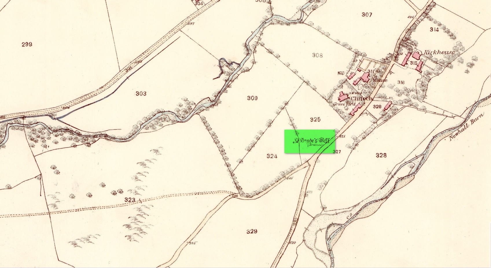
Holy Well (destroyed): OS Grid Reference – NT 3190 3339
Also Known as:
St Bryde’s Well
Archaeology & History
Site shown on 1858 map
Two hundred years ago, located halfway between Traquair’s present parish church and that of the demolished (apparently) 12th century church of St. Bride to the southwest, were the flowing waters of this once sacred water source. But it’s long since been destroyed. It was drained sometime prior to when the Ordnance Survey lads came here in 1856 and its water taken to supply the nearby manse. Subsequent surveys by the Royal Commission (1967) and Mr & Mrs Morris (1982) affirmed its demise. It was listed in the early Scottish holy well surveys, without comment, and I can find no local history accounts of the place.
References:
Hallen, A.W. Cornelius, “Holy Wells in Scotland,” in The Scottish Antiquary, volume 9, 1895.
Royal Commission on the Ancient & Historical Monuments, Scotland, Peeblesshire – volume 2, Aberdeen University Press 1967.
Walker, J. Russel, “‘Holy Wells’ in Scotland,” in Proceedings of the Society of Antiquaries of Scotland, volume 17,, 1883.
Acknowledgements:Huge thanks for use of the Ordnance Survey map in this site profile, reproduced with the kind permission of the National Library of Scotland.
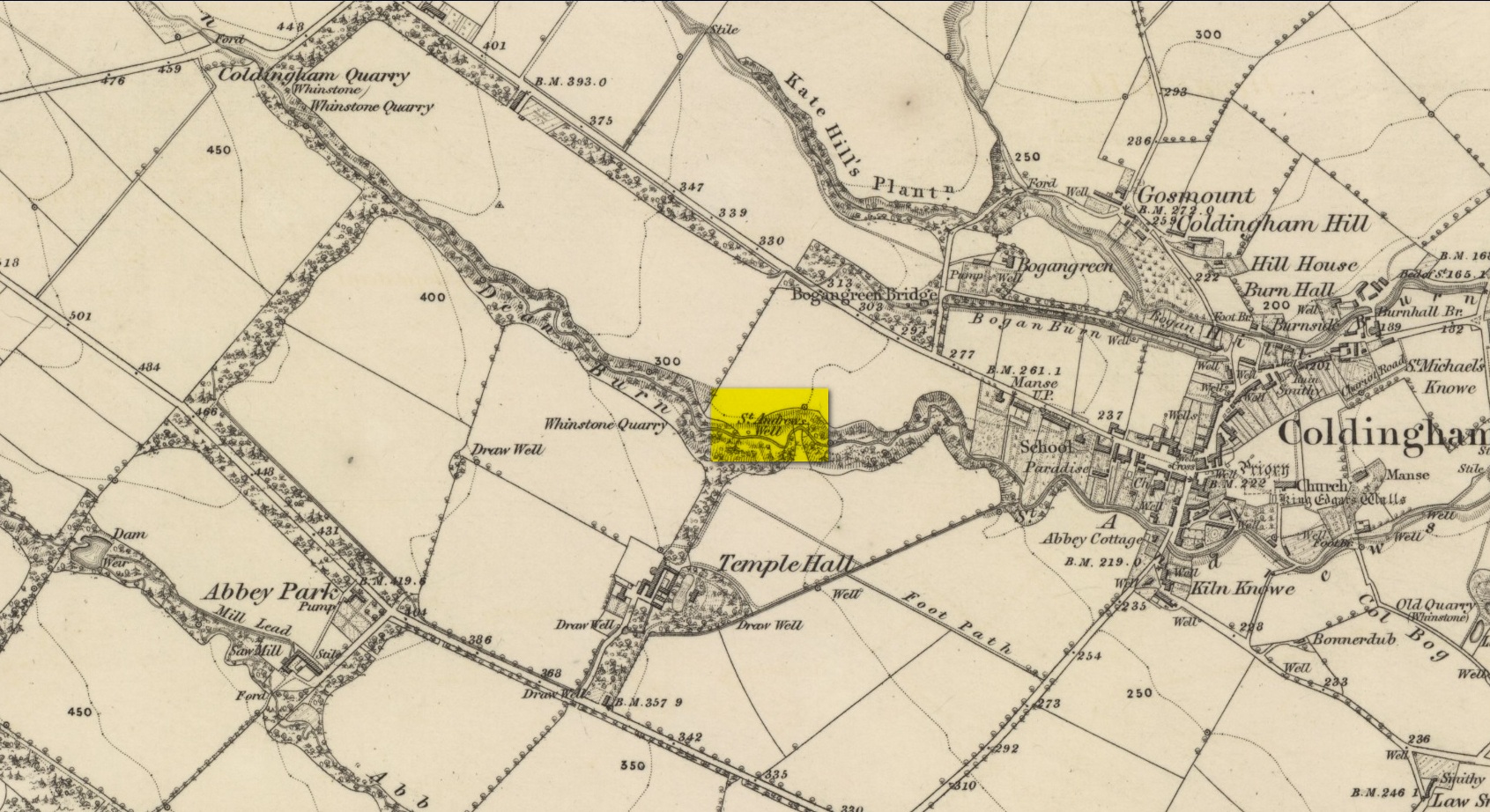
By the side of the stream known as St Andrew’s Burn, in the small wooded glen to the rear (west) of the Crosslaw Caravan Park (right by the side of the A1107 road), you can still find the flowing waters of this all-but-forgotten holy well that was dedicated to Scotland’s patron saint, god knows how long ago! The first description I’ve come across relating to the site is in William King’s (1858) early work on Coldingham Priory, where he told that,
“In a dean a little westward from the village, and on the border of the property of Bogangreen, is a spring of excellent water, called St Andrew’s Well, from which the monastery was supplied by leaden conduits, portions of which are occasionally turning up to view. These pipes are thick and well made.”
Fifty years later when Adam Thomson (1908) penned his magnum opus on Coldingham parish, the well was still in a good state of affairs. Hereby there grew much chamomile which, he thought, “the monks were wont to cultivate for the healing of the sick.”
Folklore
St Andrew’s feast day is November 30 and is known as Anermas.
References:
Hunter, William K., History of the Priory of Coldingham, Sutherland & Knox: Edinburgh 1858.
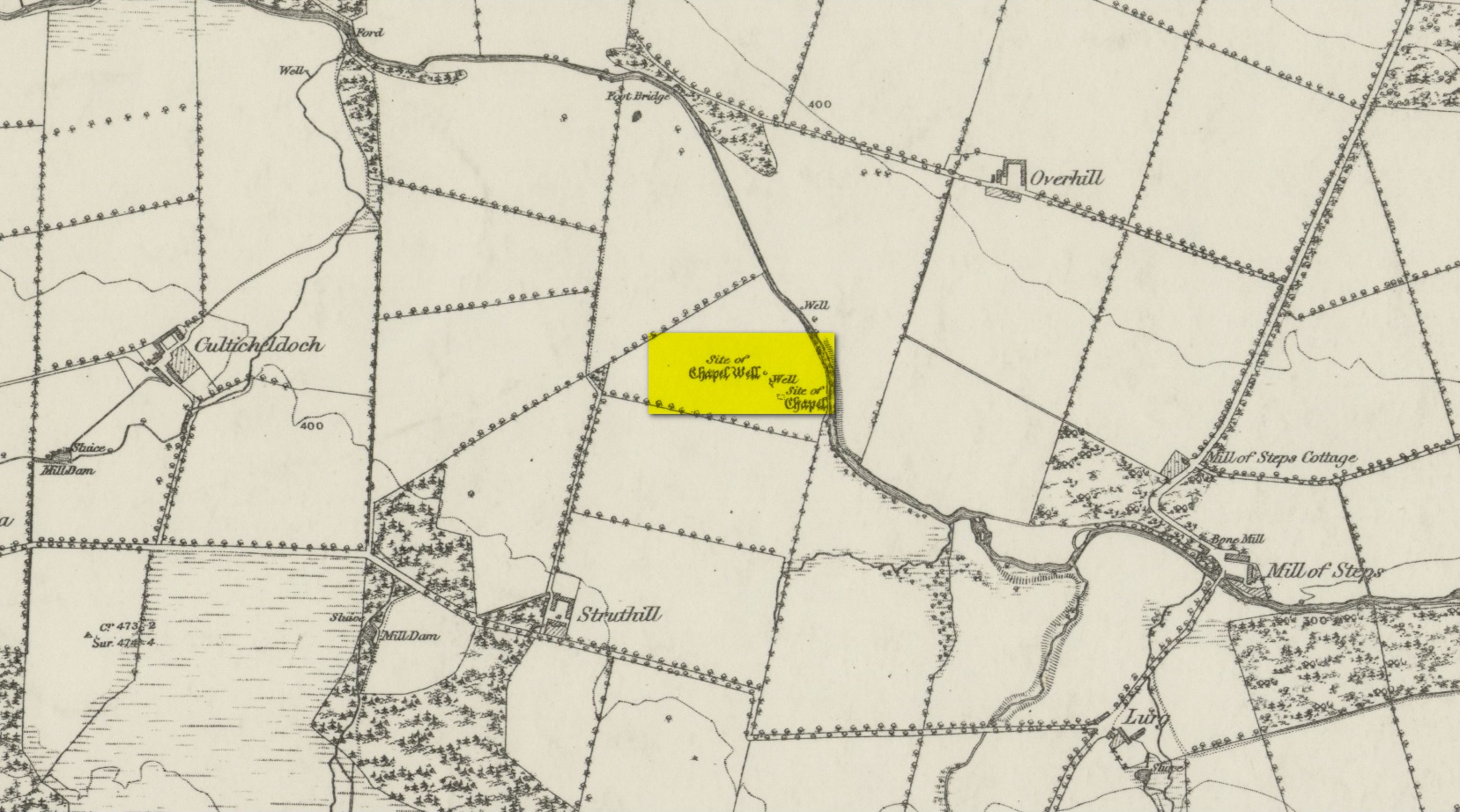
From Muthill, go up Thornhill Street out of the village for nearly 1½ miles. You’ll have just passed the double hairpin bend, crossed the rivulet, then reached the large old farmhouse of Lurgs. From here, turn right and after just over half-a-mile you reach Struthill where, running by the side of the house, is a small trackway. Ask the folks at the house, who are most helpful, and walk down the track for nearly 400 yards and go through the first gate on your right, crossing the field until it dips down to the burn. The boggy marshy mass running from near the top of the slope is what you’re looking for!
Archaeology & History
Shown on the 1863 map as the Chapel Well, the dedication of the waters to St. Patrick coincided with a chapel that once stood here, also in his name. Very low faint remains of the chapel, completely overgrown, can still be made out amidst the rushes. It’s one of two holy wells in Muthill parish that are dedicated to St. Patrick.
Very little of any real spring of water can be seen nowadays. Indeed, the site today is merely a much overgrown bog-of-a-well whose water oozes down the slope into the Juncus rushes, trickling into the adjacent burn. I had a drink of the water from the slopes, which tasted OK and did me no harm whatsoever.
Folklore
The most important aspects of this site was its use by local people and the attributes it was given. We know not how far back such folklore goes, but it would have been many many centuries, if not millenia. Water worship (if that’s the right word) is the most archaic of all traditional forms of veneration. This place was no exception. In John Shearer’s (1883) excellent local history work, he gave the following account of the site:
“About a quarter of a mile west from the Mill of Steps, upon a height on the right bank of the Machany, are to be seen the ruins of a small chapel. When other places of Popish worship were thrown down after the Reformation, the Presbytery of Auchterarder ordered it to be demolished about 1650 to repress the superstitions practised at this place of resort. West from the chapel is an excellent spring which was held in great veneration in those dark ages of superstition, when the ignorant and credulous populace were deceived by the crafty priests who stood below the spreading branches of an ancient ash which grew near the fount, pronouncing a benediction on the weary pilgrims as they drank of the waters. And as it was celebrated for its healing qualities in many different distempers, numbers yearly visited it from a great distance to benefit by its virtues with as much devotedness as the Mahometan pilgrims visit the tomb of their Prophet. Insanity was also cured here. Several persons testified before the Presbytery of Stirling, in 1668, that having carried a woman thither, they staid two nights at a house hard by the well. The first night they bound her twice to a stone at the well, but she came into the house to them being loosed without any help. The second night they bound her again to the same stone and she returned loosed. And they also declared that “she was mad before they took her to the well, but since that time she is working and sober in wits.”
“This well was still celebrated in the year 1723 and votive offerings were left, but no one then surviving appeared to appreciate the virtues of the stone. Small offerings were given in coin and thrown into the well and those who had no coin brought white stones which were laid in regular order along the declivity where the water runs to the river. Coins have been of late found in the well and the white stones are still to be seen. The officiating priest generally resided at Drummond Castle. Within the last sixty years, several of the gentry have come in their carriages to inspect these relics which were held in so great reputation in ancient times. The chapel and well are about one mile south west from Muthill.”
References:
MacKinlay, James M., Folklore of Scottish Lochs and Springs, William Hodge: Glasgow 1893.
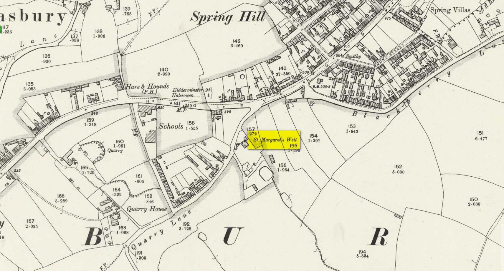
Holy Well (destroyed?): OS Grid Reference – SO 9609 8284
Archaeology & History
The site on the 1904 map
Shown on the 1904 OS-map, beneath the aptly-named St Margaret’s Hill on its northern side, we can see where the holy well of St Margaret used to be, not too long ago. Although it seems to have fallen pray to industrial destruction, there are a number of old references to the site, mainly gathered together in Jeremy Harte’s (2008) magnum opus on the subject. It was also mentioned in a survey by the British Geological Society (Richardson 1930) where we were told that it was,
“in the private grounds of a house recently erected, and is a spring issuing from the Halesowen Sandstone at the junction of two faults (shown west of the ‘H’ of Hasbury on the new series Geological Map, Sheet 168) about 100 yds SW of the point where Blackberry Lane joins Hagley Road. It is referred to, as a well of good cold unmineralised water, by T. Nash in 1781.”
And it was Mr Nash who gave us the earliest description of the place, saying:
“In the hamlet or township of Hasbury is an ancient holy well, called St Margaret’s Well, which formerly had much good stonework about it; but that was wholly removed in the year 1747. One of these stones contained some curious sculpture, the figure of a man in a posture of hasty walking, and in the next compartment that of another man leaning on crutches… This place is called Margaret’s Hill and the water of the well supplies a small brook, which runs below the Grange, and falls into a piece of water at the end of the town, called Cornbow Pool.”
It’s more than probable that the old carvings he described—of one man on crutches and the other of a figure walking speedily—represents one of the main curative allegations that these waters possessed. Cases of people walking on crutches to sacred wells, drinking the waters, then walking away without them (and in many cases leaving their crutches at the well-side as testament to its properties) are commonplace. And, aptly enough, the curative elements of this ancient site has been maintained in modern times with the medical centre of St Margaret’s Well Surgery being built by this very spot!
Holy Well (destroyed): OS Grid Reference – SK 589 789
Also Known as:
Prior Well
Archaeology & History
Once to be seen in the ancient landscape immediately northwest of Worksop Priory by the old Mill Pond, this sacred well has sadly been built over, but memory of it is still retained in Priorswell street-name and, previously, the Priorwell Brewery. Not much has been written about it, but thankfully the historian John Holland (1826) gave us a short account, saying:
“There is a spring, now enclosed, called the “Priorwell,” and a meadow, of four acres, denominated from the same; and from which, it might be presumed, that the canons would draw their supplies of water, was it not for the convenient proximity of the river, which they must have had to ford for that purpose. It was “formerly”, says Parkyns, in his Monastic and Baronial Remains, “celebrated for miraculous cures; but since monastic deceptions have unveiled themselves, votaries no longer offer, and consequently cures are no longer performed.” This may have been the case: more recently the well has been resorted to by persons having sore eyes, in the cure of which, it is said to be efficacious, and has probably the common virtue of fresh cool spring-water.”
References:
Holland, John, The History, Antiquities and Description of the Town and Parish of Worksop, J. Blackwell: Sheffield 1826.
Parkyns, George I., Monastic and Baronial Remains – volume 1, Longmans Hurst: London 1816.
White, Robert, Worksop, The Dukery and Sherwood Forest, Simpkin Marshall: London 1875.
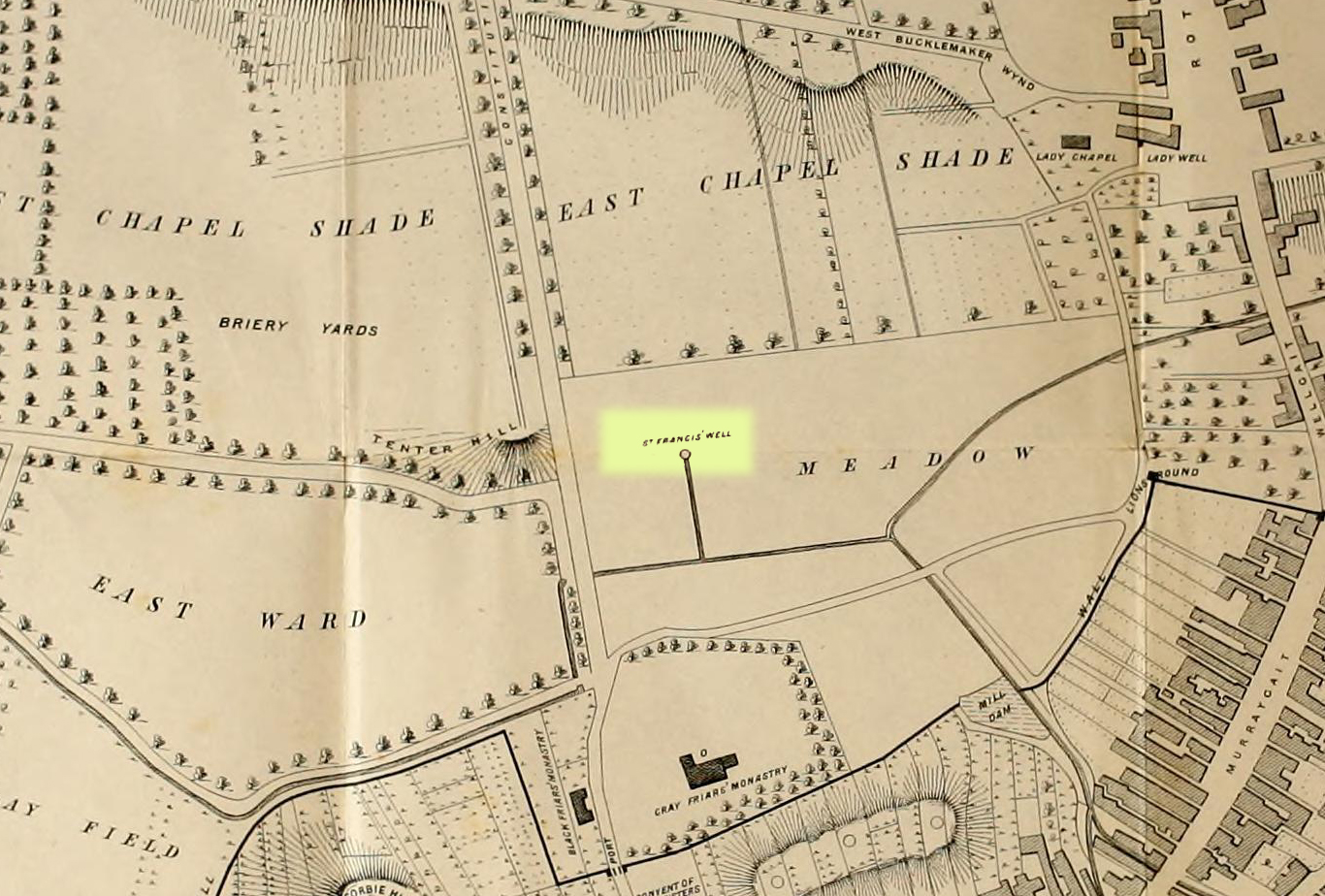
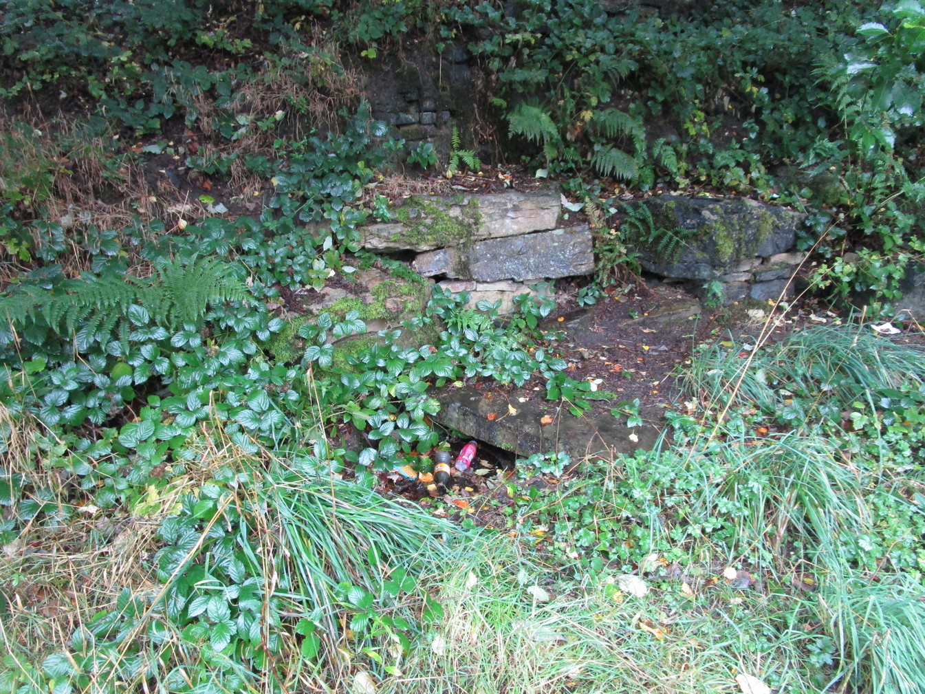
Holy Well (destroyed): OS Grid Reference – NO 4007 3046
Also Known as:
Grey Friar’s Well
Archaeology & History
Site shown on 1776 map
This is another one of Dundee’s lost holy wells (see also the Lady Well, the Nine Wells, St Clement’s Well, St Mary’s Well and Sinavey Well), around which the town was first built. Its cold fresh waters were located less than a hundred yards north of the old Houff graveyard in the middle of town, or where Alex Maxwell (1884) described as upon “the sunny slopes of the Gray Friars’ meadows.”
Maxwell told us that this sacred site was the most favoured of the the holy wells in the area, having been dedicated to St Francis of Assisi by the monks who built the medieval Grey Friars monastery, whose ruins lie beneath the Houff graveyard. After the destruction of the priory in the 16th century, the holy well and surrounding meadows came under the ownership of the local council. The well had become ruinous and so was repaired back to its old condition, but a few decades later had become very neglected again and was ordered to be closed. It was mentioned in several early land rental documents, including this from 1630 which told,
“That haugh or meadow lying on the south side of the Tentour Hill, and on the east side of the meadow called Monorgan’s croft, togidder with the lands lying about St. Francis’ well, were set for the yearly penny mail of fifty-ane pounds.”
The most extensive description of it came from Alex Maxwell’s own pen, and I reproduce it here in full. He began by speaking of the other holy wells of Our Lady and St. Clement’s in Dundee, but told us that,
“The most important of them was the Gray Friars’ well, which came out of the rising ground westward from where the High School is built, and had been dedicated to the honour of St. Francis, the founder of the order — a man of exalted character, whom Dean Milman calls “most blameless and gentle.” The water, which ran perennially and was of singular purity, had no doubt been highly venerated in the days of the old Church, and it continued to be much esteemed, and even to maintain somewhat of its traditional sanctity, long after the memory of the good man whose name it bore had become forgotten.
“When the Friars’ house was in ruins, and the gardens laid waste, St. Francis’ well did not escape unharmed. One austere iconoclast—James Patrie was his name—had probably been offended at its sculptural reminiscences of the old faith, and he cast it down. When arraigned to answer for this,
“he confest and grantit that he took down the common well callit the Friar well, quhilk servit the haill town with guid and wholesome water, and referrit him in the Bailies’ and Council’s will thereanent; and they being advisit with his offence, declarit that he sail pay for the reparation of the said well and common warks the soum of ten pounds; always, gif he big and repair the well as Weill as it wes of before with lime mortar, or Pasch next, this pain to be remitted; otherwise, the day past and the well nocht biggit, to pay the said soum but favour.”
James, however, proved contumacious; the day did pass, and the well still lay in ruins. But he got further time, for the Council not yet having possession of the monastic lands, had not chosen to act arbitrarily, and
“James Patrie was ordained to repair the Friar well conform to the last act, under the pain contenit thereintil, betwix the date hereof and Whitsunday;”
and he probably then proceeded to restore it into good condition, as we do not find any other ordinance on the matter. He had not, however, erected it very substantially; for, before thirty years had elapsed, the structure was again ruinous, and the Council resolved
“that St. Francis’ well be of new biggit and made close, so that na common access be had thereto.”
“The meadow land of the Gray Friars which lay around the well, formed a pleasant open space for the use of the old burgh, and it was always held in much regard. Early in last century, the water from the Lady well was impounded and conveyed in pipes for supplying other cisterns throughout the town ; but St. Francis’ spring, which was softer and purer, was left undisturbed to flow down the grassy slope in its natural course ; and when the place became appropriated for homely purposes, and upon
“Its verdant braes,
The lasses used to wash and spread their claes,”
“the gossiping naiads made the meadow very lively as they plashed in the brimming basins of the Friars’ old well, or filled their pitchers at the fresh fountain, or sprinkled the water in crystal showers over their snowy linen. About the time that the ground was sacrificed for the erection of buildings, a dyer in the neighbourhood sank a well which evidently reached the source of the spring and drained it off. Years afterwards, when the place had been overbuilt, he ceased to use his well, and the stream, returning to its old course, found access into the lower part of a church which now covers the site of the fountain, much to the dismay of the deacons. The water was then carried off elsewhere, and will be seen no more ; and the remembrance of those virtues which belonged to the once famous well will soon have passed away.”
In Christian lore, St Francis’ festival day was October 4.
There are various ways to find this. When we came here, we started from the Barton and Crosland Moor side, parking up on Ivy Street and walking to the fields at the end of the road. From here, walk along the track to your left and just over 100 yards on there’s a small footpath on your right that veers down the slope. Walk on here for another 100 yards, keeping your eyes peeled for another path on your right that almost doubles-back on you, heading into the trees. Another fifty yards along and you’ll see some tell-tale stonework!
Archaeology & History
An earlier, adjacent water trough?
Highlighted on the 1854 OS-map, the site has seen better days. Although the waters today emerge from a blasted rock face and collect into a relatively modern round stone trough, there is a larger square stone structure just a few yards away that seems to have been where water was previously collected. According to local antiquarian Andy H, this was known to be a local Wishing Well in bygone times, but apart from this there are no literary accounts about the place. The area was decimated by 19th century Industrialists who, as is well known, destroyed much of our indigenous histories and sites—and the Huddersfield district was particularly hard hit by them.
On a recent visit to the site—in superb pouring rain!—the waters were choked with modern trash and bottles, making it unsafe to drink. This is surely a good case for restoration, then stuck on some local tourist route to ensure better, more appreciative attention.