Holy Well (destroyed): OS Grid Reference – TA 026 223
Archaeology & History
This curiously-named, lost holy well was to be found somewhere between the old terrace at West Field and the old road of West Acridge, but even when Henry Ball (1856) wrote about it, the site had passed into history. He told that,
“In the old enclosures to the west of the town was a spring of clear water called St. Trunnion’s well, and in a field in the West Acridge a very old thorn tree called St, Trunnion’s tree, which was standing in 1736; but who St. Trunnion was is not known…”
The close proximity of the tree with the well is highly likely. Throughout the British Isles there are many relationships where sacred trees and wells of the same name are next to each other and we have little reason to doubt this was the case here. However, unless local historians can uncover some old field-name maps, the exact location of the site seems to have been lost. It was named as St Tronians in 1665; with his sacred tree mentioned in early enclosure awards dated 1681 and 1697 respectively.
The enigmatic saint ‘Trunnion’ is thought to derive, not from some old hermit or heathen holy dood, but from the corruption of an early word: “a perversion of Trin-union or Tri-union, used as an asservation or oath”; although another option cited by Cameron (1991) is that it derives from “trinune, trin-une, referring to the Trinity”—which would explain the sanctification of the waters.
Holy Well (destroyed): OS Grid Reference – TA 032 222
Archaeology & History
Not far from the middle of this small town there lived, many centuries ago, a sacred spring of water dedicated to St. Catharine. Described in local field-names from 1697 (as St. Catherin’s Well), all trace of it has long since vanished. Indeed, even when Henry Ball (1856) wrote about it, local knowledge of it had already fallen into obscurity. He could merely tell us that,
“At the end of Newport, in what was called “the Colony,” was St. Catharine’s Well, and the road from thence to Finkle lane was named Catharine street.”
Folklore
St Catharine’s festival date—known as Cattern Day in some parts of England—is November 25.
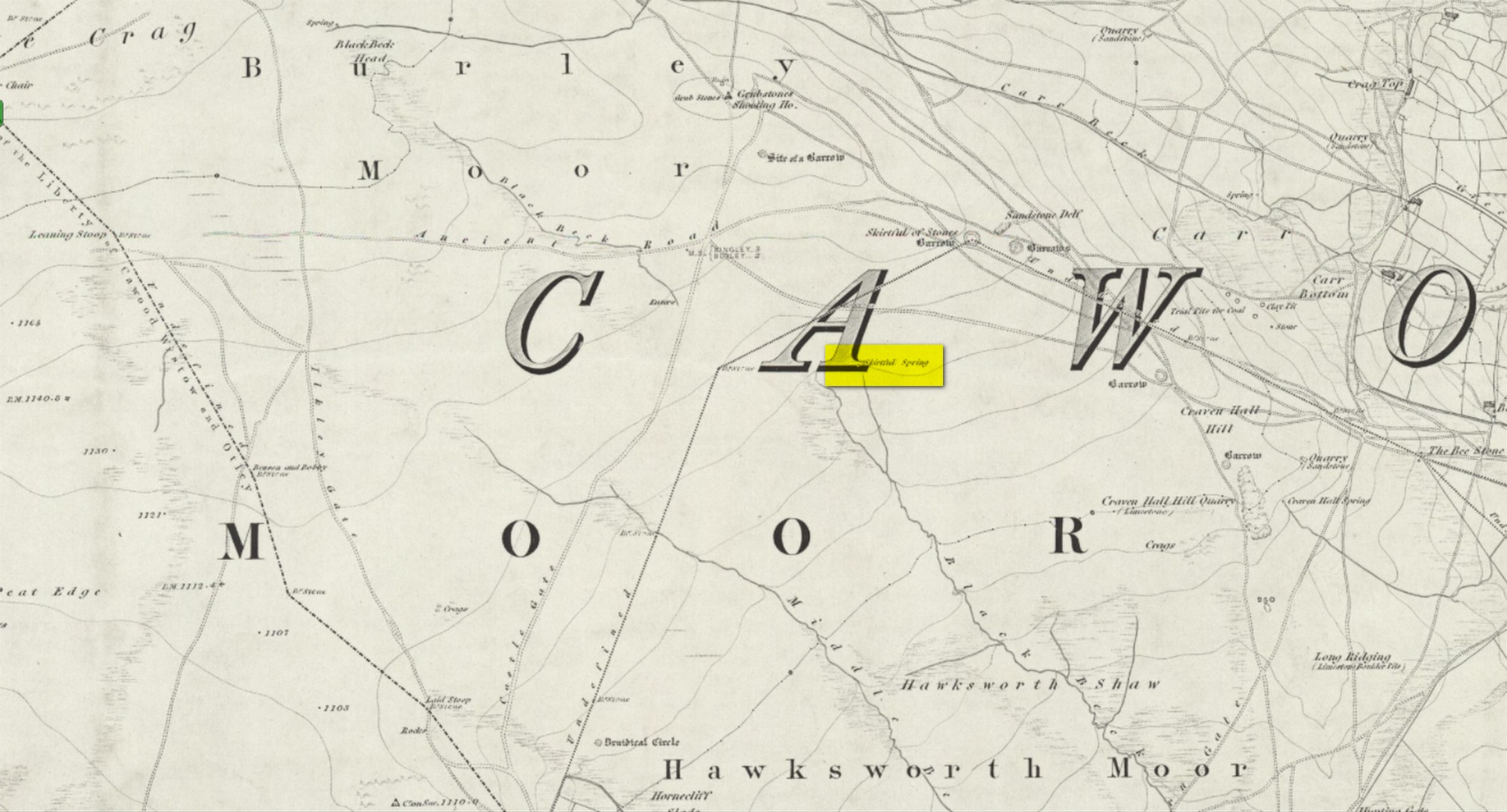
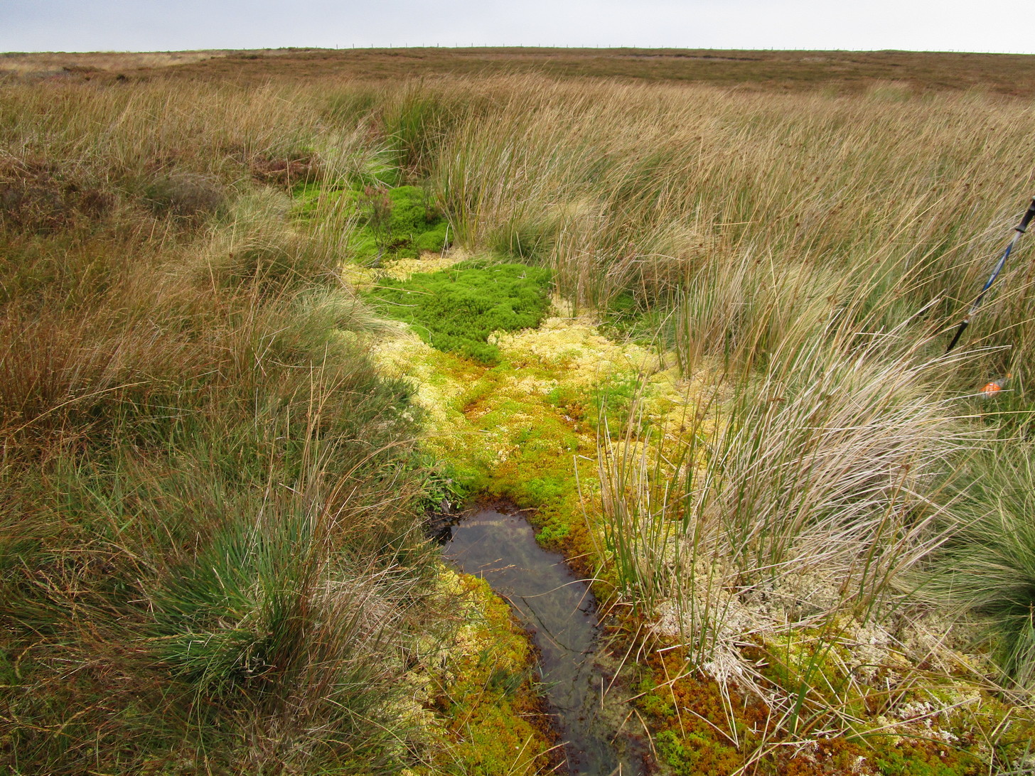
Easiest way to find this is from the Great Skirtful of Stones. From here, follow the line of the fence 250 yards south, then climb over and walk dead straight south onto Hawksworth Moor for 150 yards. You can clearly see the mass of reeds and marshy ground way before you reach it; just be very careful not to walk straight into the reeds or you’ll get sucked down into the waters—and it’s pretty dodgy if you walk into the wrong spot, with good old Jenny Greenteeth lurking beneath the surface!
Archaeology & History
The Skirtful Spring
Highlighted on the 1851 OS-map of the area, this all-but-forgotten clear spring emerges a short distance south of the Great Skirtful of Stones and adjacent to the Hawksworth Moor cairnfield—a proximity that was probably not without meaning in prehistoric times. Curious though it may sound, in traditional cultures across the world, water is as much an important ingredient in the cosmologies of the dead as it is in the land of the living. In earlier centuries this water-source was much more fast-flowing and wider than it is today and it would obviously have been vital for our prehistoric ancestors. Its virtues and folklore have long since been forgotten.
Holy Well (destroyed): OS Grid Reference – NT 2523 4045
Archaeology & History
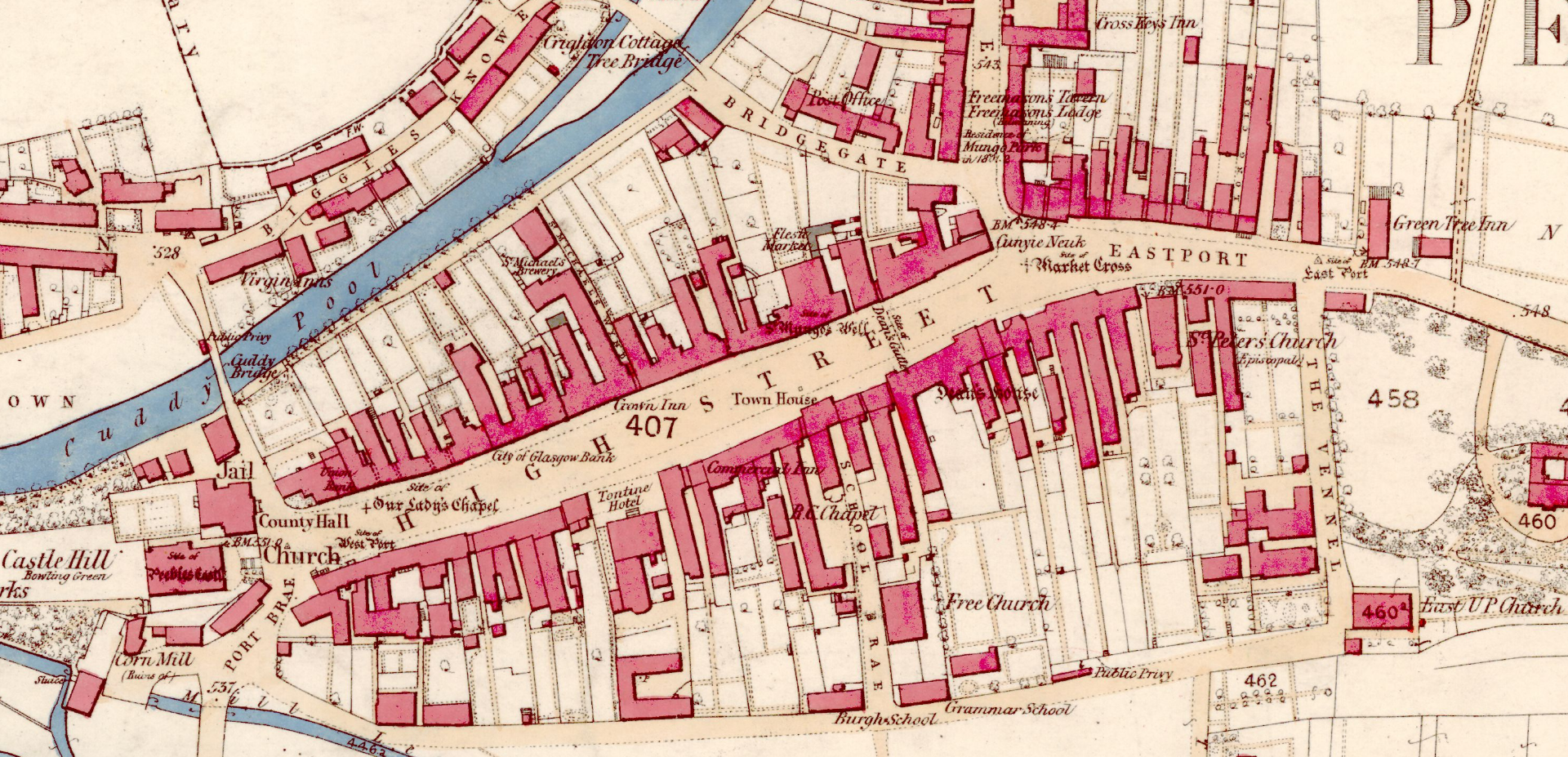
St Mungo’s Well, 1858 map
Highlighted on the 1858 OS-map, two-thirds the way up the High Street, this long forgotten sacred well was described by the Ordnance Survey lads in their Name Book (1856) as “an excellent spring”—and no doubt an ever-flowing one, even in the greatest of droughts. But it had already been destroyed when they came here. It was mentioned in passing by William Chambers’ (1856), who described it as a “public fountain” dedicated to old Mungo, a.k.a. St Kentigern. But its position in the High Street wasn’t where it originally emerged. Local tradition told it was once on the slopes of Venlaw immediately north of the town, possibly making it into the folklore category of “Wells that Move”—usually because the spirit of the place has been offended.
But in truth, little is known about its mythic history. Its origin seems, as with so many ancient sites, entangled in what Dr Gunn (1908) in his definitive work on the history of Peebles church explained, the heathen “superstitious regard for fountains”, pre-dating the christian dedications. St Mungo himself, said Gunn,
“is remembered in Peebles to-day by his holy well upon the slopes of Venlaw, hallowed by its use in the Sacrament of Baptism.”
It’s profane history tells simply that, in 1728, its waters were piped into the trough on High Street for public use. It became damaged sometime in the early 19th century, but some remains of the stonework were found when roadworks were done here in 1845. It would be good if we could recover further information about this important holy well.
References:
Chambers, William, A History of Peeblesshire, W. & R. Chambers: Edinburgh 1864.
Holy Well (destroyed): OS Grid Reference – NT 4598 4454
Archaeology & History
At the edge of the ruins known as the Bishop’s Palace, up the slope behind the ruined church in Stow, could once be seen the waters of the Bishop’s Well which, wrote Thomas Wilson (1924), fed the palace hereby and was used by the clergy. Apart from a barely discernible circular depression at the edge of the old manse ruins, no trace of this site remains.
References:
Royal Commission Ancient & Historical Monuments, Scotland, Inventory of Monuments and Constructions in the Counties of Midlothian and West Lothian, HMSO: Edinburgh 1929.
Wilson, Thomas, The Stow of Wedale, Aberdeen Newspapers 1924.
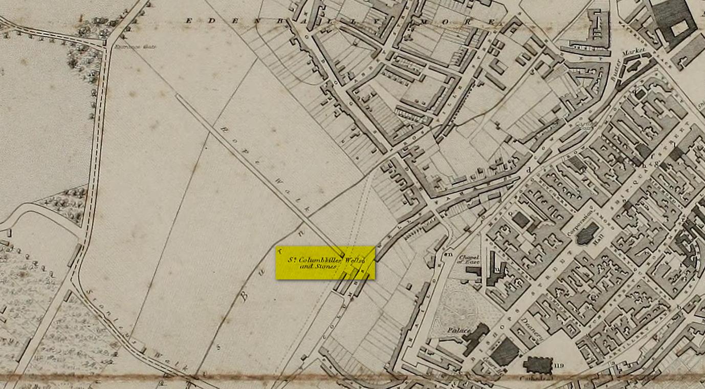
Holy Well (destroyed): OS Grid Reference – C 43117 16615
Archaeology & History
Long since gone, there are very few references to this once sacred site, which seemed to comprise of three sacred wells next to each other, each with its own formal dedication. This would have made it one fuck of an important place in early- and pre-christian times. But even when Thomas Colby (1837) and his mates surveyed the area, it seems like it was on its last legs. He told that:
Site on Colby’s 1837 map
“As connected with the ancient history of Derry the sacred springs, called St. Columb’s Wells, claim some notice in this place. They are, or rather were, three in number — for one has been dried up, or diverted from its original locality — and are situated near the Roman Catholic chapel, outside the wall. It appears from the Irish annals that each of these wells had its peculiar name, one being called Tobar Adamnam, another Tobar Martain, and the third Tobar Colum — but the two former names are now quite forgotten, and the springs are popularly called St. Columb’s Wells. They are regarded with much superstitious veneration by the Roman Catholic peasantry, but no celebration of St. Columb’s festival is now held at them.”
The wells were found very close to St. Columba’s bullaun stone, which possessed its own healing abilities. The two sites had symbiotic ceremonial relationships with each other, doubtless performed in bygone centuries on St. Columba’s old festival date of June 9.
References:
Colby, Thomas, Ordnance Survey of the County of Londonderry, HMG: Dublin 1837.
Doherty, William, Derry Columbkille, Brown & Nolan: Dublin 1899.
Not to be confused with the other St. Columba’s Stone at Shantallow, 1¾ miles to the north of here, this legendary rock was found in very close association—barely ten yards away—with one of St. Columba’s holy wells (in fact there were three holy wells hereby, but the others were dedicated to saints Adamnan and Martin). The two sites were inextricably related to each other, both in terms of their proximity and, more importantly, in terms of the symbiotic traditions the two of them had. And despite the relationship they had under the guise of one “St. Columba”, it’s pretty obvious that this was a thoroughly unchristian place to begin with.
St Columba’s Stone in 1837
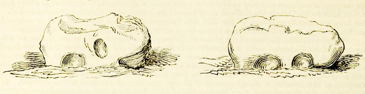
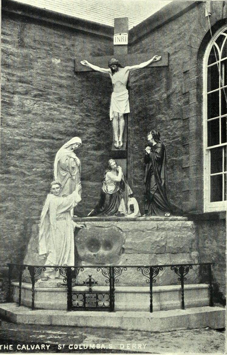
As with many bullauns, it’s a relatively small stone with two deep hollows on either side. We don’t know for certain when the stone was placed here, but tradition tells us it was sanctified at this spot in the 6th century; and so it remained until June 9, 1897 when, deemed as being an “obstruction” on the roadway, it was uprooted and moved some 300 yards south where, a year later, it was incorporated into the base of a cross outside the Long Tower Church of St Columba, where it remains to this day (at grid-reference C 4303 1635).
The stone was still in situ when Thomas Colby (1837) and his mates were doing their work for the Irish Ordnance Survey, at a period when many an Irish antiquity was still frequented by local folks for ceremonies, both personal and social. Colby wrote:
The stone set beneath the cross
“In the centre of St. Columb’s Lane, adjacent to the Wells, there is a remarkable stone, called St. Columb’s Stone, which is popularly regarded with a still higher veneration by the aboriginal Irish of the district. It is of an irregular form, about three feet long, and ten inches wide: the height above ground is one foot and a half, and it has two oval hollows on each side, artificially formed. Many foolish legends are current among the peasantry respecting the origin of these hollows, which, it is supposed, are the impressions made by the saint’s knees when he leaped from the nail of the city. It may, however, be worth observing, that stones of this description are found in the vicinity of most of the Irish churches, and usually bear the name of the founder, or patron saint: they are always held sacred, and the rain-water, deposited in their hollows, is believed to possess a miraculous power in curing various diseases.”
William Doherty (1899) told how parts of the bullaun holes had been made “by pious pilgrims trying to remove chips as relics”, who then wore them as amulets for curative properties and good fortune; then later, “it was utilized as a Holy Water Font, to prevent further mutilation.”
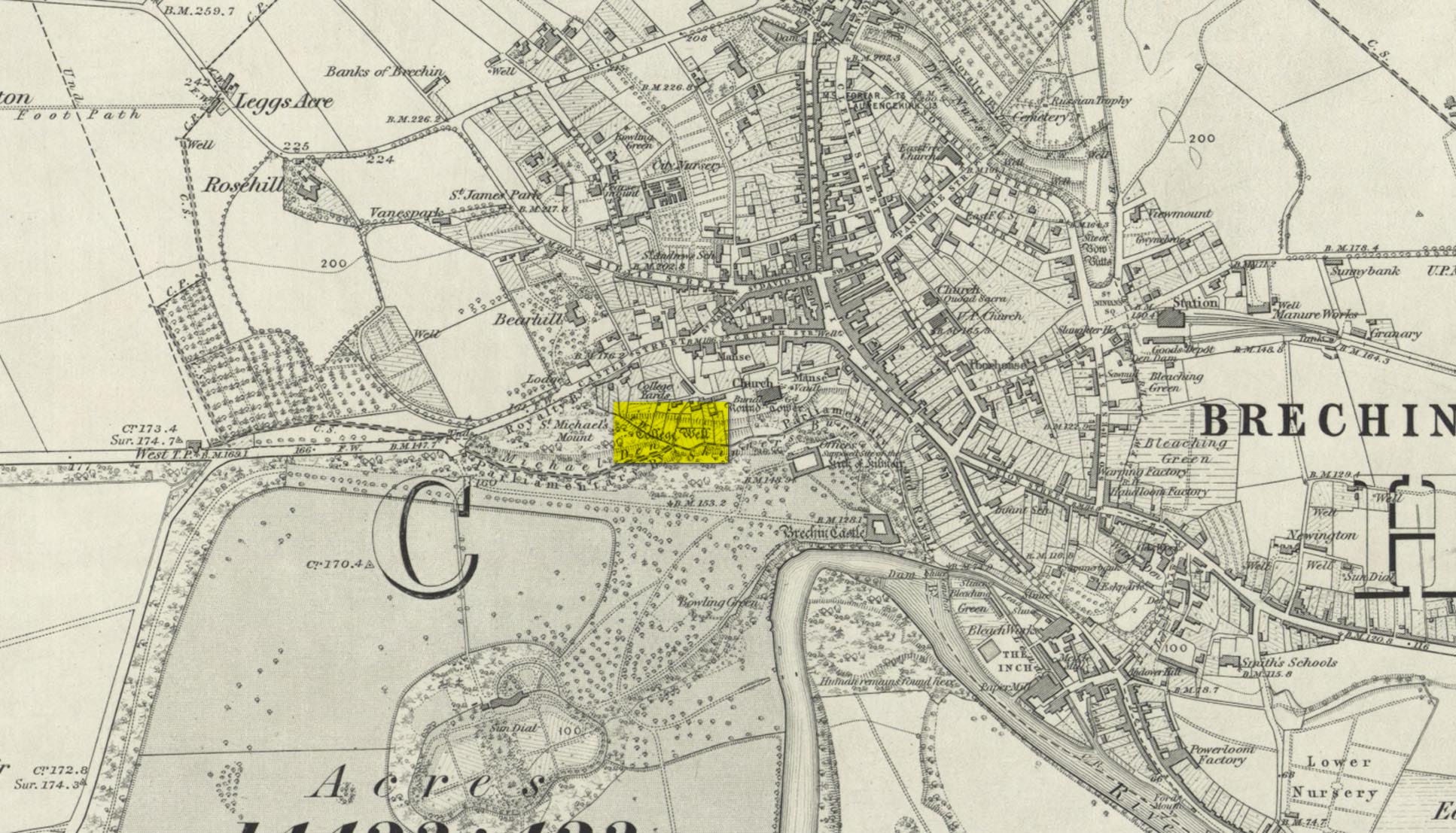
Highlighted on the 1865 OS-map, this lost water source was located between the Brechin cathedral/round tower and the curiously-named St. Michael’s Mount, whose history seems to be lost. It would seem to be the well which Ruth & Frank Morris (1981) name as the ‘Ancient Well’ in their survey.
Folklore
The reason behind this site being classified as a sacred (or holy) well is based on the tradition that the Culdees had a religious convent here in the 12th century and, according to David Black (1839),
“This convent is believed to have stood a little to the west of the present parish church, in the gardens now belonging to the kirk-session, still called “the College Yards.” A small well of delightfully pure water in these gardens receives the name of the College Well, and is reported, by tradition, to have been the well of the Culdee convent.”
On the issue of St. Michael, students of folklore will know that, in the christian cult, he was an early dragon-slayer. His annual commemoration day is September 29. One of his shamanistic functions “relates to the very old tradition of Michael as the receiver of the souls of the dead.” (Attwater 1965)
References:
Black, David D., The History of Brechin, Alexander Black: Brechin 1839.
Gibson, Colin, Folklore of Tayside, Dundee Museum c.1968.
Acknowledgements: Huge thanks for use of the 1st edition OS-map in this site profile, Reproduced with the kind permission of the National Library of Scotland.
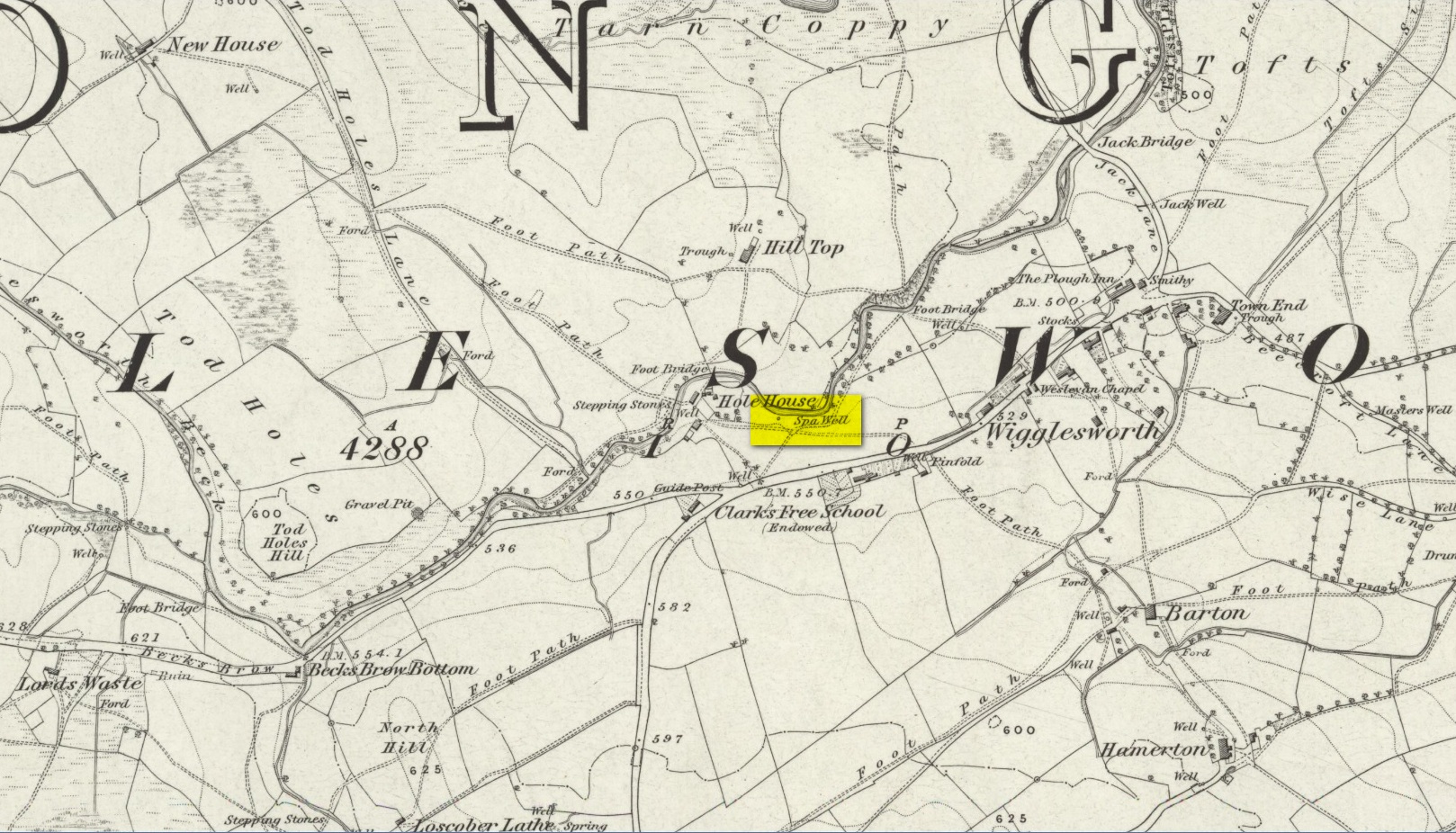
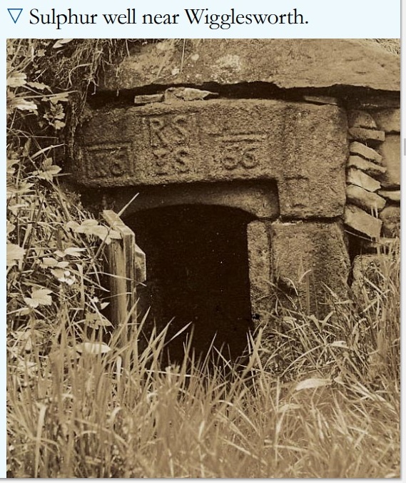
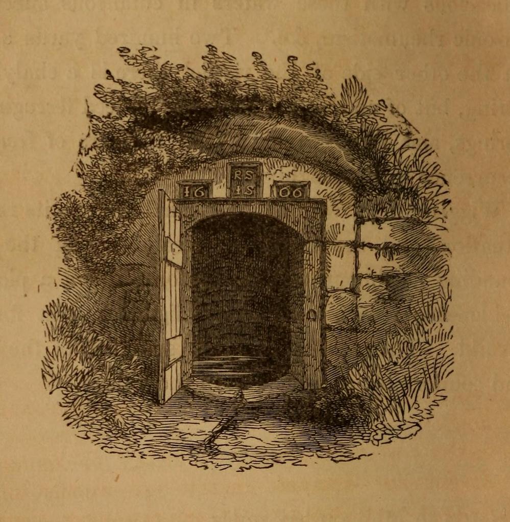
In William Addison’s (1951) standard work on the history and development of Spa Wells, he told us that “the spas began as holy wells”; yet in spite of him listing the Wigglesworth Spa in his work, such “holiness” wasn’t a feature found here and, sadly, we have no written records that tell of any. But that doesn’t mean to say it had no sense of importance or animistic sacrality to local people. The earliest written record we have of this Sulphur Well is to be seen on the stone-work at the top of the small well-house, where the year “1666” was carved, marking the year when the structure was built under the directions of a local rich dood. But earlier knowledge of these healing waters would have been passed to the land-owner by local people, as indicated in Thomas Short’s (1765) words where he told that “it has been used time out of mind.”
Mr Short (1724) makes mention of this Sulphur Well in his gigantic early work, but only in its similarity in both taste and smell to the Sulphur Well at Harrogate and letting us know that, “I have tried carefully” the waters of the two sites. We had to wait another forty years before he gave us a more detailed account of the medicinal properties here. He wrote,
“Now come we to a sulphur water of a very peculiar nature, such as I never met with or heard of in England besides, and deserves to be much more strictly examined and enquired into, viz. Wigglefworth Spaw, near Settle, in the parish of Long-Preston. It has been used time out of mind, and more formerly than at present, because it is little known; rains and drought affect it not. Country people drink four or five pints of it in a morning to vomit them, and six or seven pints to purge them. The water is very black, smells strong of sulphur, has a very small stream, but stagnates not, bubbles not, but springs up; it is always covered with a white scum, (and) dies all in its course white. It rises out of a great stone soil, near much lime-stone, at the foot of a hill. It tastes salt, yet curdles not soap, and boils with milk. A phial glass, one third part full of it, well corked, and tied down with a bladder, and set in the cold water to be evaporated; when the water began to boil, it was taken out and poured a little of it on solution of silver, which turned black and curdled. The phial was corked again, and set half an hour longer in the boiling water, it still turned solution of silver black. It was corked a third time, and set half an hour longer in the boiling water, then tried, but was not so black as before, and caused little curdling. This last stood all night, next day its precipitation was blackish; the water was clear above. This is the only blackish sulphur water I have met with (as Rippon is a greenish yellow) and retains its sulphur the longest, from its contained oil.”
Consistent with other writers of his time, Mr Short then wrote at length on how the Wigglesworth waters reacted to various chemical tests, many of which were done in order to indicate the veracity, or otherwise, of any medical qualities. He also made comparative studies between this and the sulphur wells at Harrogate and elsewhere, and concluded that the Wigglesworth Spa would successfully deal with the following ailments or conditions:
“Sloth, idleness, too violent slavish exercise or labour, too great affluence, or plenty of nourishing rich high foods, spices, forced meats, acrid, stimulant and aromatic viands; the earthy viscid dregs of fermented liquors, or the parching, drying, shriveling spirits of wine, sugar, fruits, grain, or fermented liquors, as well as poverty and unwholesome diet, irregular hours, etc, are the parents of many diseases, whose cure lies in relieving oppressed nature from the unwieldy load (brought upon her by indolence, gratifying the vitiated taste, intemperance and debaucheries) by cleansing and rousing the vessels, restoring the juices to a healthy state; rectifying and establishing the secretions and excretions of the body, and restoring vigour and activity to the fibres, vessels and solids. To the above causes of diseases, we may add pride, luxury, sensuality, inverting the natural course of time, turning day to night, and night to day. These give birth to many chronic diseases, as well as acute, from acidities, crudities, viscidities in the stomach, communicated thence to the bowels, and so to the whole habit; hence are vitiated juices, great obstructions, and a long train of diseases affecting sundry parts of the body, and therein the whole nervous system, with hypo, hysterics, melancholy, costiveness, or looseness, suppression of natural necessary discharges, etc., which require thinning, relaxing, resolving, opening, or invigorating remedies.”
Photo of the well, c.2008Howson’s 1850 sketch
For about two centuries this well had a very favourable reputation. It’s therefore slightly curious as to why the great spa-writer, A.B. Granville, in his visit to this part of Ribblesdale to seek out some of the medicinal springs in the 1830s (including a petrifying well), made no mention of our Sulphur Well. Whether this was due to his patronizing attitude towards local people isn’t known, but it certainly wouldn’t have helped him in Yorkshire! One might suggest it was due to the fact that the spa had fallen into disuse, but this wasn’t the case because, subsequent to Granville’s visit, the local writer William Howson (1850) later told us that,
“In the woody dingle to the north of the village is a sulphurous spring, protected by a neat and antique stone canopy bearing the date 1666, and the initials of Sir Richard Sherburne and Isabella his wife, a daughter of John Ingleby of Lawkland Hall. Of this well, Dr (John) Murray the well-known analytical chemist says, ” It is a most valuable and unusually strong sulphuretted water, and as far as I have examined mineral waters, second to none.” From his analysis and that of Dr. Garnett it appears that a gallon of the water contains seventeen cubic inches of sulphuretted hydrogen, four of azote, and a small portion of carbonic acid, sulphate of magnesia in the proportion of seventy five grains to a gallon, a considerable quantity of muriate of soda, and a minute proportion of carbonate of lime.”
(The aforementioned Dr Garnett was a renowned 18th century authority on medicinal wells in Yorkshire, best known for his works on the spa wells of Halifax (1791) and Harrogate (1791, 1792), along with some in Scotland.)
Messrs Short (1765) and Howson (1850) mentioned other medicinal springs very close by, including the Chalybeate Well in the field immediately north on the other side of the stream.
References:
Addison, William, English Spas, Batsford: London 1951.
Brown, G.H., Walks, Drives and Excursions around Settle, Craven Printing: Settle 1880.
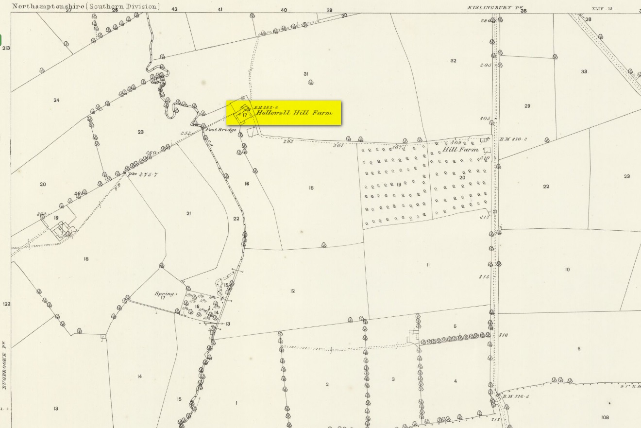
A mile south of Kislingbury village, just by the roadside is the old Hill Farm. In times gone by—as the early OS-maps show—a trackway led from here, westwards, for just a few hundred yards, until it reached the old farm of Hollowell Hill, all trace of which has long since gone. The farm owed its name to the existence of a holy well mentioned briefly in 14th century records in the Cartulary of St. Andrews, Northampton, where it was described as Halywellhille, or the Holy Well on a hill. All trace of it seems to have been lost. A ‘Spring’ that is shown on the 1885 map, a few hundred yards south of the old farm, seems to be the closest contender, but it seems more likely that the well was adjacent to, or beneath the farm-building.
References:
Gover, J.E.B., Mawer, A. & Stenton, F.M., The Place-Names of Northamptonshire, Cambridge University Press 1975.