Morphing Stone, Dacre, North Yorkshire

Cup-and-Ring Stone:  OS Grid Reference – SE 18559 61795

Also known as:

  1. Snoopy Stone
  2. Eastwoods Rough Carving
  3. IAG 638a (Boughey)

Getting Here

Mr Stroud's drawing of the stone
Mr Stroud’s drawing of the stone

Various ways to get here.  I s’ppose the easiest is from Dacre village.  If you go just past Sunny House, take the footpath on your right & walk along it, roughly straight across a number of fields, until you hit the footpath known as the Nidderdale Way.  The field you’re now in should be scattered with numerous rocks all over the place (if it aint, you’re in the wrong place), reaching down towards the trees.  Walk straight towards the trees for another 100 yards and the carving is somewhere hereabouts under your nose!  You’re very close! If, however, you decide to walk up the Nidderdale Way from Dacre Banks, the field you need is the one immediately to your right just before you reach the Monk Ing Road trackway.  The Tadpole Stone (or Eastwoods Rough II carving) is in the same field, close to the Nidderdale Way path — check that out aswell!

Archaeology & History

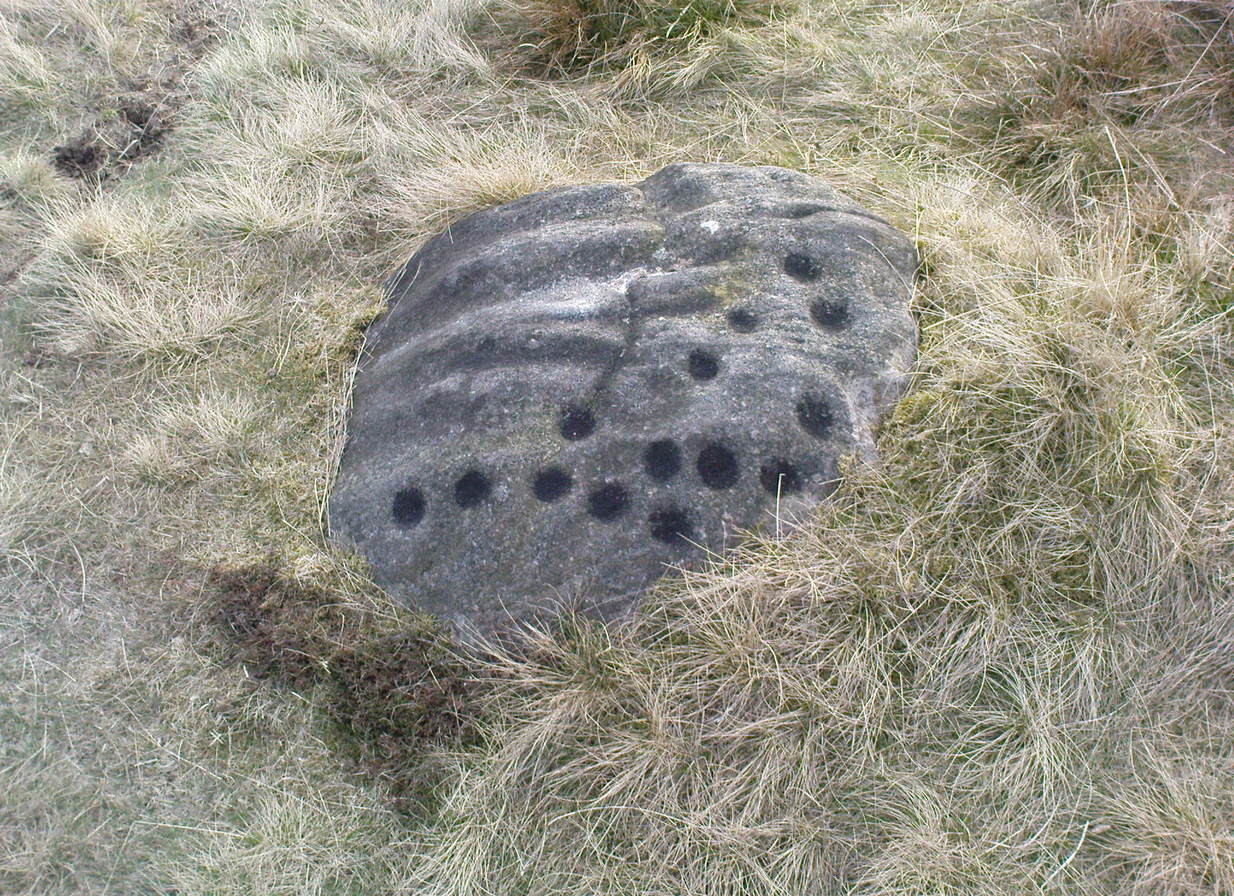
This is a large carving I found in April, 2006, in the company of rock-art student Richard Stroud (who sent us the pictures).  Twas in the midst of a fine day wandering about checking some of the ‘known’ sites in the area, when we happened across two or three previously unknown sites — and as the day wore on, just before we were gonna head for home, this little beauty poked the edge of its head out of the turf!  It had the pair of us in near rapture, with numerous “Wow’s” and excitable expletives coming from our mouths! We’re easily pleased us rock-art doods — but then it is a beauty when you first see it.

Morphing Stone carving (photo © Richard Stroud)
Morphing Stone, Dacre (photo © Richard Stroud)

We came here several times in the weeks following its initial discovery, and it seemed that on each visit, we found an additional aspect to the carving.  It seemed to keep changing each time we came here — hence the name ‘Morphing Stone’!

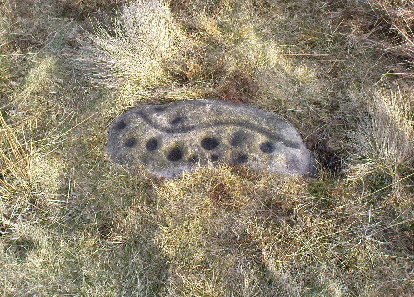
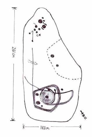
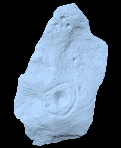
The prime feature in the carving is the very large oval-shaped ‘ring’ with huge carved bowl in the middle and several outlying cups-markings around it.  Although it’s not plain to see in the photos, there’s a large tongue-shaped protuberance jutting out from one side of the main ringed feature.  You can also see a small cluster of cup-marks on the top-right of the rock: from here — though it isn’t easy to see in the photo — a long straight line links up with the edge of the major central ring.  Other lines run off on the top of the main feature and there are several other cup-markings on different parts of the stone.  It’s obviously best to see the carving “in the flesh”, so to speak, to get a good impression of what it actually looks like.  And, to those of you who might wanna venture up here, there are several others nearby.

A year or two after rediscovering the carving, rock art student Keith Boughey (2007) described the stone, saying:

“Measuring 2.61m from N-S and 1.88m from W-E at its greatest extent, the carved surface carries quite a complex design… At its N end is a large cup/basin with an approximate diameter of 25-30cm, surrounded by a ring that may or may not be complete: 2 cups have been incorporated into the ring on its N and W side. W of this ring a groove leads off S to a further possible cup. On the E side of the large central cup are 3 further cups of varying size. These motifs are all enclosed within a wide groove, which forms almost a dome pattern. Out of the ring, a further groove runs NW out of the design, bisecting the enclosing groove, curving round to form a handle shape before running back in towards the large central cup. The groove shows signs of continuing E towards the edge of the stone. Just outside the W edge of the enclosing dome is one well-defined cup. S of this, in a slight depression, are 2 further cups of differing size. A straight groove appears to run SW out of the enclosing dome shape on its E side towards further motifs on the stone’s S side. The groove may run into an area of cup marks, but there appears to be a break before it continues. When exposed, the carvings looked quite fresh and sharp, suggesting that they had remained covered for some considerable time – possible since antiquity or at least from a time in the prehistoric past when cup-and-ring-markings had begun to lose their significance and were no longer required to be visible in the landscape.”

To those of you who like the new computer images of cup-and-rings, the three below are samples from a number of such images done after the stone had been discovered.  Intriguingly, the long line running between the cluster of cups to the large cup-and-ring doesn’t show up too well; but the barely perceptible line running out, zigzag-fashion, from the large central cup-and-ring, shows up much clearer than when looking with the naked eye.

                          Morphing Stone Nikon Morphing4
References:

  1. Boughey, K., “Prehistoric Rock Art: Four New Discoveries in Nidderdale,” in Prehistoric Research Section Bulletin, no.44, Yorkshire Archaeological Society 2007.

© Paul Bennett, The Northern Antiquarian


Weecher Stone Circle, Faweather, Baildon, West Yorkshire

Stone Circle (destroyed):  OS Grid Reference – SE 1372 4196

Getting Here

Although destroyed, to those who wanna check the locale, from Bingley take the Eldwick road and keep going all the way up to Dick Hudson’s public house, right on the edge of the moor.  From here, go left (east) on the road for less than a mile until you reach the reservoir/lake on your right.  Take the dirt-track down here for 100 yards and stop!  It was somewhere here!

Archaeology & History

I first went looking for this site when I was a kid (about 13 years old), but soon discovered that it had been destroyed.  The first person to write about it was lucky enough to see it when it was still there.  Harry Speight came here around 1890 and described,

“descending (from Pennythorn Hill) towards Faweather we enter (by permission) a field at Birch Close Farm, and here we find evidence of an extensive stone circle, some of the large unhewn stones having been built into an adjoining wall. In the next field is a rock sculpture with…cup and ring marks.”

This cup-marked stone still exists at Faweather, though has now been enclosed by a garden. The occupiers are quite friendly and are willing to let you look at the stone if you ask kindly.  Anyway…..by the time Butler Wood wrote about the place in 1905, he was telling that “the finest stone circle in the Rombald’s Moor area was demolished some years ago.”

The local historian W.E. Preston, marking an old map of the region with an “X,” wrote:

“NOTE! The circle was destroyed here during construction of the Baildon Waterworks, 1892. Diameter 25 yards. It consisted of a wall of rubble with upright stones at frequent intervals.”

Subsequent descriptions of the site in 1905, 1929 and 1946, cited Weecher to be 27 yards across.  My last search for any remains of this circle was in 1990 when I explored every wall in the region, hoping to find one or two of the old uprights, but they had all gone. Sadly, there appear to be no drawings or illustrations of the site either…

Folklore

This stone circle was one of at least four circles that played a part in one of the most impressive leys I have seen! Starting at the circle in Hirst Woods, Saltaire, the alignment goes north, crossing the Brackenhall circle, a few other Bronze Age sites, across the site of Weecher, and finally terminates at the Great Skirtful giant tomb a short distance north of here.

References:

  1. Bennett, Paul, The Old Stones of Elmet, Capall Bann: Milverton 2001.
  2. Cowling, E.T., Rombald’s Way, William Walker: Otley 1946.
  3. Gray, Johnnie, Through Airedale from Goole to Malham, Walker & Laycock: Leeds 1891.
  4. Raistrick, Arthur, ‘The Bronze Age in West Yorkshire,’ in YAJ 1929.
  5. Wood, Butler, ‘Prehistoric Antiquities of the Bradford District,’ in Bradford Antiquary, 2, 1905.

© Paul Bennett, The Northern Antiquarian


Middleton Moor Carving (454), North Yorkshire

Cup-Marked Stone:  OS Grid Reference – SE 10980 51284

Archaeology & History

Carving no. 454

About 10 yards north of the old boundary stone on the Middle Ridge heading to the western end of Dryas Dike and about 10-15 yards east of the Middleton 453 carving, is this small rounded rock with between 12 and 15 cup-markings on its north and north-eastern sides.  Several curious deep ridges run down across the rock which some ascribe as being man-made – but to me they’re Nature’s fine handiwork, although I may be wrong…

References:

  1. Boughey, Keith & Vickerman, E.A., Prehistoric Rock Art of the West Riding, WYAS 2003.

© Paul BennettThe Northern Antiquarian

Middleton Moor Carving (453), North Yorkshire

Cup-and-Line Stone:  OS Grid Reference – SE 10968 51279

Archaeology & History

Carving no. 453

Named boringly after the catalogue number given it in Boughey & Vickerman’s (2003) survey, this is another of the many small cup-marked stones clustered at the western end of the ridge between Delves Beck and Dryas Dike, below the moorland slope up to the Old Pike and Beamsley Beacon.  It’s one of the more impressive of the carvings in this locale, albeit when it’s highlighted, as in the photos shown here (apparently done by one of the photographers in the Ilkley rock art group, I was told).  It’s perhaps better seen when the sun is low and the stone’s been wet, which shows the shallow undulations of the cup-marks and wavy line that seems to split the main group of twelve cup-marks  at the top northern side of the stone, from the two on its south side.  There seems to be another wavy line carved above the main cluster, but this is difficult to make out.

References:

  1. Boughey, Keith & Vickerman, E.A., Prehistoric Rock Art of the West Riding, WYAS 2003.

© Paul BennettThe Northern Antiquarian

Middleton Moor Carving (440), North Yorkshire

Cup-Marked Stone:  OS Grid Reference – SE 10875 51390

Getting Here

Middleton Moor CR-440

From the old T-junction in the hamlet of Langbar (where some doods have stuck up one of those ‘Private Road’ signs, typical of those Southern-types who bring their weird private land notions up here), go along the ‘private road’, keeping to the left until the road runs out. Then follow the small footpath above the house onto the moor, following the lines of walling along, crossing boggy streams, up the small hill and, once over the top and dropping down, keep your eyes peeled for the large boulder to the left of footpath, and a small scattered cairn on your right.  It just a few yards past the cairn material!

Archaeology & History

Just 20-30 yards up the slope on the north side of Dryas Dike stream, to the left of the footpath, is a small, rounded flat stone with perhaps as many as eight cup-markings on it.   Six seems more believable — though some of ’em on here (if not all) don’t look to have the air of authenticity that some of the other carvings hereabouts possess.  One of the cups has a small ‘tail’ protruding from it.  It’s a rather cute little thing!  A small, unexcavated cairn lies in ruin about 10 yards east of the crude carving.

…and from another angle

On the other side of the footpath from here is that “large boulder” I mentioned above, which is reported by Boughey & Vickerman (2003) to have “one clear cup” marking etched upon it.  They also report that archaeologists from “English Heritage report two cups and a possible short groove” on this rock. However none of the carvings reported here by either authority are man-made.  All marks on the rock are completely natural and it needs omitting from any future archaeological survey.

References:

  1. Boughey, Keith & Vickerman, E.A., Prehistoric Rock Art of the West Riding, WYAS 2003.

© Paul Bennett, The Northern Antiquarian


Middleton Moor Carving (003), North Yorkshire

Cup-and-Ring Stone:  OS Grid Reference – SE 11288 51542

Getting Here

In the middle of the moors, with no footpaths close by.  Unless you’re a rock-art freak I guess there aint gonna be too many people searching for it!  From the Ilkley-to-Langbar road, take the track (Parks Lane) onto the moor where the road bends right.  Follow it up for about a mile (though it doesn’t seem that far) and where the cup-marked stone at the edge of the wall where the spring appears (Middleton Moor carving 483), walk west (left) into the heather for a coupla hundred yards below Foldshaw Ridge.  Look around!

Archaeology & History

Little-known cup-marked stone on Middleton Moor (photo courtesy Richard Stroud)
Cup-marked stone, Middleton Moor (photo © Richard Stroud)

This is one of a small cluster of carvings Richard Stroud found on a few average-sized stones prettty close to each other in April 2005 — and one which the West Yorkshire Archaeology Service told him couldn’t be there cos the region had already been surveyed.  Hmmm…

Crap drawing!

Well, my first impression of this when I saw it was a absolute thumbs-up! Simple to look at, I know – but a bloody good little carving.  It’s primary characteristic is that most of the ten or eleven cups occur on the vertical and near-vertical face, which aint too common.  In traditional societies (though not all) where carvings occur on vertical faces, they’re deemed to be ‘male’ in nature (those on rounded smooth surfaces, female).  The carving is well worth checking out — especially as there’s probably more to be found up here, hiding beneath ages of peat and heather.

© Paul Bennett, The Northern Antiquarian


Middleton Moor Carving 002, North Yorkshire

Cup-and-Ring Stone:  OS Grid Reference – SE 1154 5202


Photo by Richard Stroud

Getting Here

To find this, follow exactly the same directions as that of the Middleton Moor Carving 001, which is just a few yards away. Both of these stones may take some finding when the heather’s deep — but when we first discovered them, the heather had recently been burnt back.

Archaeology & History

This small rounded stone had a covering of vegetation on it when Richard Stroud and I first discovered it in April 2005, with just a couple of cups visible, but once the heather’d been carefully rolled back, another fine carving greeted our keen-eyed petroglyphic senses!

Drawing of the carving
…and again!

At least eight cups seem apparent here, though once Richard had the photos processed there appeared to be a couple of things on the stone which we hadn’t noticed when in the field (a common cup&ring dilemma). One of the most curious parts of the stone seems to be the winding line near the bottom of the stone. Make of it what you will!

Just a couple of yards east of this carving we find the rounded remains of a single burial cairn, probably for just one person, just like as with Middleton Moor 001.  This site could do with excavating, as we may have a small neolithic or Bronze-Age cemetery hiding under the heath.

© Paul Bennett, The Northern Antiquarian


Middleton Moor 001, North Yorkshire

Cup-and-Ring Stone:  OS Grid Reference – SE 11545 52017

Photo by Richard Stroud

Getting Here

Go up the long winding Ilkley-Langbar country moorland road.  A coupla miles along there’s a sharp bend in the road, left, with a dirt-track here that takes you onto the moors.  Walk up here to the shooting house just east of Black Hill in the Middleton Moor enclosure and, once there, walk up the steepish slope to the left (west). Once on the level, head to the wall and about halfway along, look around.  If the heather’s long and deep you’ll be lucky to find it.  Good luck!

Archaeology & History

Photo by Richard Stroud
Sketch of the carving

The carving was first discovered by Richard Stroud and I in April, 2005, amidst one of several exploratory outings to records known sites and, aswell, to keep our eyes peeled in the hope that we might find some new ones!  This was the first we came across; but when we found it, just one faint cup seemed noticeable on the southern edge of the small rounded stone; but after fifteen minutes of carefully rolling back the vegetation, this very well-preserved carving was eventually unveiled before us.  It’s in quite excellent condition!  The most notable part of the design are the two deep cup-markings, with the topmost cup looking half-surrounded by smaller cups on its southern edge.

There is also a well-preserved, though overgrown burial cairn (probably for one person) just a few yards west of this stone.  This is just about impossible to see unless the heather’s been burnt back.

© Paul Bennett, The Northern Antiquarian


Black Hill Long Cairn, Low Bradley, Skipton, North Yorkshire

Cairn:  OS Grid Reference – SE 0092 4756

Also Known as:

  1. Black Hill Long Barrow
  2. Bradley Moor Long Barrow
  3. Bradley Moor Long Cairn
  4. King’s Cairn

Getting Here

Follow the same directions for getting to the Black Hill Round Cairn.  It’s less than 100 yards away – you can’t miss it!

Archaeology & History

This is a superb archaeological site — and it’s bloody huge! It’s big and it’s long and it sticks out a bit – which is pretty unique in this part of the Pennines, as most other giant cairns tend to be of the large round variety.  Although the site was originally defined by Arthur Raistrick (1931) as a long barrow, J.J. Keighley (1981) told how, “it was found to be a round cairn imposed on a long cairn.”  And it’s an old one aswell…

Near the SE end of the giant cairn
Close-up of the main cist

More than 220 feet long and 80 feet in diameter at its widest southeastern end, as we walk along the length of the cairn to its northwestern edge, its main body averages (only!) 45 feet in diameter.  Made up of tens of thousands of rocks and reported by Butterfield (1939) to have had an upright stone along its major axis, the “height varies from 4-8ft, but the cairn has been much despoiled and disturbed,” said Cowling in 1946. He also told how,

“Excavation revealed that almost in the centre of the mound were the remains of a cist made of roughly dressed stone flags and dry walling, covered by a large stone. Under a stone slab, laid on the floor of the cist, were fragments of (burnt and unburnt) bone and a small flint chipping.”

This is a very impressive site and deserving of more modern analysis. The alignment of the tomb, SE-NW, was of obvious importance to the builders, believed to be late-neolithic in character.  The tomb aligns to two large hills in the far distance in the Forest of Bowland which we were unable to identity for certain.  If anyone knows their names, please let us know!

Folklore

The older folk of Bradley village below here, tell of the danger of disturbing this old tomb. In a tale well-known to folklorists, it was said that when the first people went up to open this tomb for the very first time, it was a lovely day. But despite being warned, as the archaeologists began their dig, a great storm of thunder, lightning and hailstones erupted from a previously peaceful sky and disturbed them that much that they took off and left the old tomb alone. (I must check this up in the archaeo-records to see if owt’s mentioned about it.)

References:

  1. Ashbee, Paul, The Earthen Long Barrow in Britain, Geo Books: Norwick 1984.
  2. Butterfield, A., ‘Structural Details of a Long Barrow on Black Hill, Bradley Moor,’ in YAJ 34, 1939.
  3. Cowling, E.T., Rombald’s Way, William Walker: Otley 1946.
  4. Keighley, J.J., ‘The Prehistoric Period,’ in Faull & Moorhouse’s West Yorkshire: An Archaeological Survey, I, WYMCC: Wakefield 1981.
  5. Raistrick, Arthur, ‘Prehistoric Burials at Waddington and Bradley,’ in YAJ 30, 1931.

© Paul Bennett, The Northern Antiquarian


Black Hill Round Cairn, Low Bradley Moor, Skipton, North Yorkshire

Cairn:  OS Grid Reference – SE 0087 4753

Also Known as:

  1. Black Hill Cairn
  2. Bradley Moor Round Cairn
  3. Queen’s Cairn
The Black Hill Round Cairn, Bradley Moor - looking north
The Black Hill Round Cairn, Bradley Moor – looking north

Getting Here

Various ways here.  Best is probably taking the footpath onto Farnhill Moor a few hundred yards east of Kildwick Hall.  Head for the cross-bearing Jubilee Tower (supposedly built upon an ancient cairn), NW, keep going past it uphill until you reach the walling 350 yards north, where a seat let’s you have a rest.  Climb over the wall! Alternatively, walk eastwards and up through the steep but gorgeous birch-wooded slopes of Farnhill Wood; and as the moortop opens up before you, the great pile of rocks surmounts the skyline ahead. You can’t miss it! (NB: the spot cited on the OS-map as the cairn is in fact another site, 100 yards NW)

Archaeology & History

Its an awesome place in an awesome setting. You can see 360-degrees all round from this giant mass of rocks — something which was of obvious importance to the people who built it. If it had been placed 20-30 yards either side of here, that characteristic would not occur. Indeed, this is the only place anywhere on these moors where such a great view was possible. Important geomancy, as they say (or whatever modern term they give it these days).

Bradley Moor Cairn - looking down to the Long Cairn
Bradley Moor Cairn – looking down to the Long Cairn
Small section of the old cairn

Although the tomb is still of considerable size (at least 100 feet across) and made up of thousands of stones, it has been severely robbed of stone in years passed, for walling and other building materials.  A number of other small cairns scatter the heathlands a few hundred yards roundabout this central giant (though are hard to find in the deep heather); and there is a distinct cairn circle about 100 yards to the northwest, which has yet to be excavated.  This cairn circle can be made out quite easily if you stand on the ridge about 30 yards west of here, looking down the slope.  An then of course we have the equally huge  Black Hill Long Cairn, less than 100 away, aligned northwest-southeast, which obviously had an important archaeological relationship with this giant round cairn.  Also around this and the adjacent long cairn, numerous flints and scrapers have been found, showing humans have been here since at least the early neolithic period.  And recently, what seems to be a fallen standing stone has been found laying in the heather, 168 yards to the north.

This site in particular gives me the distinct impression that it was the most important of the various sites upon these moors. It’s got a distinctly female flavour to it – and it’s old name of the Queen’s Cairn seems just right.  Maybe it’s the fact that when I first visited the place, a great thunderstorm broke through the previously perfect skies, scattering lightning bolts all round for perhaps thirty minutes — so I stripped myself naked and reached my arms out-stretched, cruciform, screaming to the skies in the pouring rain!  Thereafter, no clouds appeared in the skies for the rest of the day.  It was a brilliant welcome to the place!

References:

  1. Cowling, E.T., Rombald’s Way, William Walker: Otley 1946.
  2. Keighley, J.J., ‘The Prehistoric Period,’ in Faull & Moorhouse’s West Yorkshire: An Archaeological Survey, I, WYMCC: Wakefield 1981.
  3. Raistrick, Arthur, ‘Prehistoric Burials at Waddington and Bradley,’ in YAJ 119, 1936.

© Paul Bennett, The Northern Antiquarian